

Franklin0529
-
Posts
1,621 -
Joined
-
Last visited
Content Type
Profiles
Blogs
Forums
American Weather
Media Demo
Store
Gallery
Everything posted by Franklin0529
-
Extreme Cold, Snow & Sleet: SECS 1/24 - 1/26
Franklin0529 replied to TriPol's topic in New York City Metro
I have a hard time buying the CMC progression with that cold dome overhead. Ukie smashes us with a foot Plus all snow -
Extreme Cold, Snow & Sleet: SECS 1/24 - 1/26
Franklin0529 replied to TriPol's topic in New York City Metro
Same -
Extreme Cold, Snow & Sleet: SECS 1/24 - 1/26
Franklin0529 replied to TriPol's topic in New York City Metro
-
Extreme Cold, Snow & Sleet: SECS 1/24 - 1/26
Franklin0529 replied to TriPol's topic in New York City Metro
If you're optimistic. I'm all in -
Extreme Cold, Snow & Sleet: SECS 1/24 - 1/26
Franklin0529 replied to TriPol's topic in New York City Metro
Yea nobody would be upset with a foot that ends with a little sleet -
Extreme Cold, Snow & Sleet: SECS 1/24 - 1/26
Franklin0529 replied to TriPol's topic in New York City Metro
January 96 an pd2 did -
January 25-26 Winter Storm Potential
Franklin0529 replied to Ralph Wiggum's topic in Philadelphia Region
Not much further then what's being shown. The primary will die off an pop a coastal -
Extreme Cold, Snow & Sleet: SECS 1/24 - 1/26
Franklin0529 replied to TriPol's topic in New York City Metro
Yea. All big storms always usually do mix at some point around here -
Extreme Cold, Snow & Sleet: SECS 1/24 - 1/26
Franklin0529 replied to TriPol's topic in New York City Metro
Really amped. Mixing issues Brooklyn? -
Extreme Cold, Snow & Sleet: SECS 1/24 - 1/26
Franklin0529 replied to TriPol's topic in New York City Metro
Euro gonna be more amped this time. I don't think ukie or CMC like though -
Extreme Cold, Snow & Sleet: SECS 1/24 - 1/26
Franklin0529 replied to TriPol's topic in New York City Metro
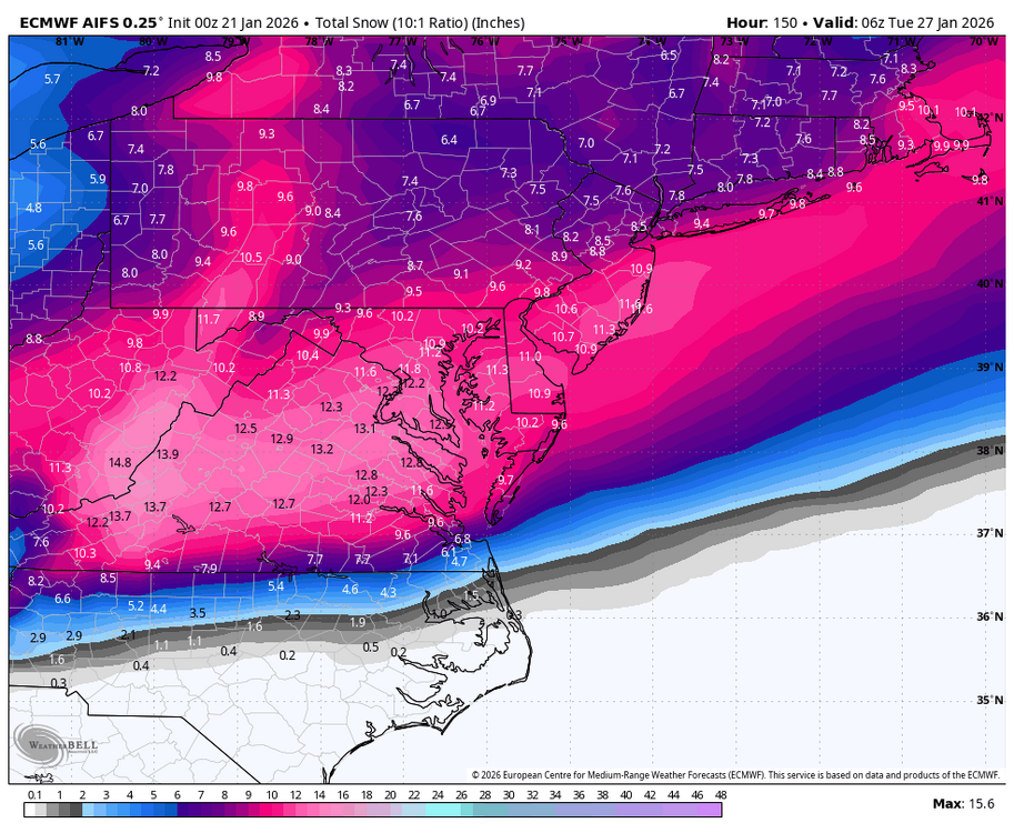
Euro AI is beautiful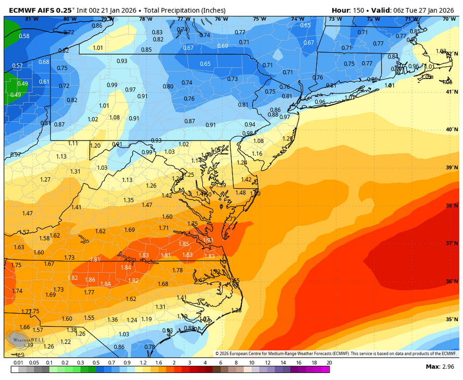
-
Extreme Cold, Snow & Sleet: SECS 1/24 - 1/26
Franklin0529 replied to TriPol's topic in New York City Metro
Can't see that happening -
Extreme Cold, Snow & Sleet: SECS 1/24 - 1/26
Franklin0529 replied to TriPol's topic in New York City Metro
Yup looks like 18" -
Extreme Cold, Snow & Sleet: SECS 1/24 - 1/26
Franklin0529 replied to TriPol's topic in New York City Metro
Ukie looking really amped too -
Extreme Cold, Snow & Sleet: SECS 1/24 - 1/26
Franklin0529 replied to TriPol's topic in New York City Metro
Wow that CMC run was extreme. -
Extreme Cold, Snow & Sleet: SECS 1/24 - 1/26
Franklin0529 replied to TriPol's topic in New York City Metro
Yea Icon is beautiful -
Extreme Cold, Snow & Sleet: SECS 1/24 - 1/26
Franklin0529 replied to TriPol's topic in New York City Metro
They do it down in the mid Atlantic forum -
Extreme Cold, Snow & Sleet: SECS 1/24 - 1/26
Franklin0529 replied to TriPol's topic in New York City Metro
Models tend to overdue the strength of HP. If it's weaker it'll come north like it's been trending. Get this to 0z Thursday an we'll be in business -
Extreme Cold, Snow & Sleet: SECS 1/24 - 1/26
Franklin0529 replied to TriPol's topic in New York City Metro
All good brother!! Lfg an bring this bad boy home!! -
Extreme Cold, Snow & Sleet: SECS 1/24 - 1/26
Franklin0529 replied to TriPol's topic in New York City Metro
Can't wait to see some of the outrageous solutions the same gonna start pumping out Tommorow an Thursday -
Extreme Cold, Snow & Sleet: SECS 1/24 - 1/26
Franklin0529 replied to TriPol's topic in New York City Metro
Setting our goalpost. Gfs about as low as we probably go. Euro highest -
Extreme Cold, Snow & Sleet: SECS 1/24 - 1/26
Franklin0529 replied to TriPol's topic in New York City Metro
Gonna wait till Thursday to make the decision to head down to family place in Ocean City Maryland. I've done a few chases down there it's great -
Extreme Cold, Snow & Sleet: SECS 1/24 - 1/26
Franklin0529 replied to TriPol's topic in New York City Metro
Good to see GFS coming around. -
Extreme Cold, Snow & Sleet: SECS 1/24 - 1/26
Franklin0529 replied to TriPol's topic in New York City Metro
GFS AI way north -
Extreme Cold, Snow & Sleet: SECS 1/24 - 1/26
Franklin0529 replied to TriPol's topic in New York City Metro
Yea the icon would've been a foot Plus. Gfs looking much better early on also


