

Franklin0529
-
Posts
1,621 -
Joined
-
Last visited
Content Type
Profiles
Blogs
Forums
American Weather
Media Demo
Store
Gallery
Everything posted by Franklin0529
-
Storm potential January 17th-18th
Franklin0529 replied to WeatherGeek2025's topic in New York City Metro
Coastal areas might be the place to be Sunday. -
Storm potential January 17th-18th
Franklin0529 replied to WeatherGeek2025's topic in New York City Metro
Nothing big but a 2-4" storm would make many happy. Plus the fun starts tracking wise next week with multiple chances -
Storm potential January 17th-18th
Franklin0529 replied to WeatherGeek2025's topic in New York City Metro
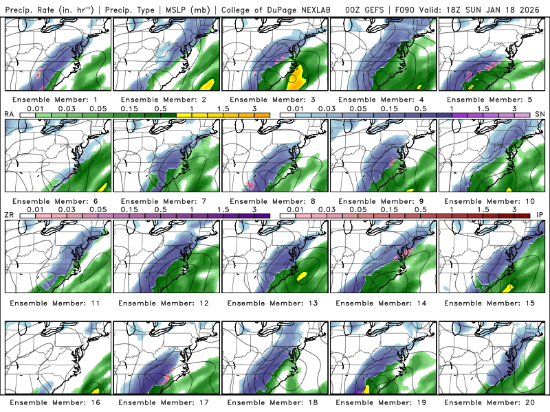
Euro coming west. Pretty close to the GFS now -
Storm potential January 17th-18th
Franklin0529 replied to WeatherGeek2025's topic in New York City Metro
Take into consideration these models tonight an Tommorow will have full data samples from the West Coast for the first time -
Storm potential January 17th-18th
Franklin0529 replied to WeatherGeek2025's topic in New York City Metro
Looks weak AF -
Storm potential January 17th-18th
Franklin0529 replied to WeatherGeek2025's topic in New York City Metro
Shocker -
Storm potential January 17th-18th
Franklin0529 replied to WeatherGeek2025's topic in New York City Metro
I give you props, you always go down with the sinking ship -
Storm potential January 17th-18th
Franklin0529 replied to WeatherGeek2025's topic in New York City Metro
This threat is done. Icon is wayyy east. I want what the rgem is smoking -
Storm potential January 17th-18th
Franklin0529 replied to WeatherGeek2025's topic in New York City Metro
The kicker in the Great lakes is mucking it all up -
Storm potential January 17th-18th
Franklin0529 replied to WeatherGeek2025's topic in New York City Metro
Same. I'm totally ok with a couple inches. Was never expecting anything big. Hopefully can pull something off -
Storm potential January 17th-18th
Franklin0529 replied to WeatherGeek2025's topic in New York City Metro
Nope -
Storm potential January 17th-18th
Franklin0529 replied to WeatherGeek2025's topic in New York City Metro
I don't need a blizzard. Give me 4-8" snow falling during the football game an I'll be a happy camper -
Storm potential January 17th-18th
Franklin0529 replied to WeatherGeek2025's topic in New York City Metro
Ukie was close but just offshore. Definitely a move towards the GFS though -
Storm potential January 17th-18th
Franklin0529 replied to WeatherGeek2025's topic in New York City Metro
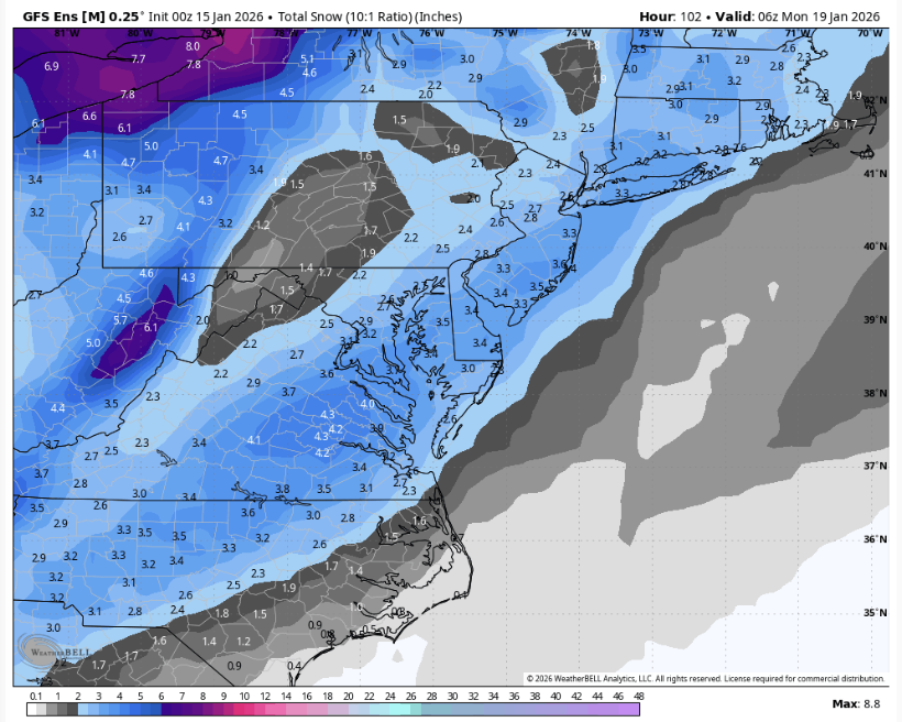
-
Storm potential January 17th-18th
Franklin0529 replied to WeatherGeek2025's topic in New York City Metro
-
Storm potential January 17th-18th
Franklin0529 replied to WeatherGeek2025's topic in New York City Metro
Yes!! Some really strong members. -
Storm potential January 17th-18th
Franklin0529 replied to WeatherGeek2025's topic in New York City Metro
Looks like it gets here. -
Storm potential January 17th-18th
Franklin0529 replied to WeatherGeek2025's topic in New York City Metro
It took a pretty good size jump west. You do realize the storm is still 4 days away right? Every model has been trending west. Not saying a GFS blizzard is on the table. But a few Inches certainly isn't out of the question -
Storm potential January 17th-18th
Franklin0529 replied to WeatherGeek2025's topic in New York City Metro
You'll buy what the nam is selling at 100hrs but not the GFS? Are you sure you an weenie man I mean snowman 19 aren't the same people -
I'm from the NYC sub. But I enjoy y'all pbp an talk in here much more. Looks like the name gonna be good
-
Storm potential January 17th-18th
Franklin0529 replied to WeatherGeek2025's topic in New York City Metro
Not shocking coming from you. I wouldn't be surprised to see a 2-4" -
euro says what storm?
-
Gets going to late. More of NE storm.
-
It's under 120 hrs. I wouldn't call that long range
-
Yup I was just coming to say. That Sunday deal came north about 300 miles since yesterday


