
BBasile
-
Posts
2,292 -
Joined
-
Last visited
Content Type
Profiles
Blogs
Forums
American Weather
Media Demo
Store
Gallery
Everything posted by BBasile
-
Coming down nicely still. Up to 1.9".
-
Have about 0.9"of fluff here. 27F
-
First flakes. 30.5F
-
We've got virga. 30F, RH 78%
-

E PA/NJ/DE Winter 2023-2024 OBS/Discussion
BBasile replied to The Iceman's topic in Philadelphia Region
Low this morning was 12.9F. Lowest temp since December 2022. Currently 13.4. -
E PA/NJ/DE Winter 2023-2024 OBS/Discussion
BBasile replied to The Iceman's topic in Philadelphia Region
The trees are sparkling this morning. 13.9F -
E PA/NJ/DE Winter 2023-2024 OBS/Discussion
BBasile replied to The Iceman's topic in Philadelphia Region
RadarOmega is also nice for mobile. RadarScope has a program for Windows and Mac, as well. Best bet for the price. I have GR3, GR2A, and RS for Windows. More than half of the time, I just open RS. And it's less than 10% of the price of the other two combined. lol -
E PA/NJ/DE Winter 2023-2024 OBS/Discussion
BBasile replied to The Iceman's topic in Philadelphia Region
Finally got a proper aerial snow cover photo. Just need one where the streets are covered as well. -
Back to pingers. 27.5F
-
All this freezing rain....no es bueno.
-
Precip has stopped for now, but everything is white. All that matters!
-
2.3" of snow/sleet. 25.7F
-
I'm guessing between .5 and .75". Already more than all of last winter. Good to see everything covered!
-
It's starting to turn white!
-
Surprised this isn't virga. RH is 70. Edit: I'm a parrot, apparently. ↑
-
We've got micro flakes. 27.3F
-
E PA/NJ/DE Winter 2023-2024 OBS/Discussion
BBasile replied to The Iceman's topic in Philadelphia Region
Had a sunlit city this morning before the clouds moved in. Hoping this view has a bit more white in it tomorrow morning. -
E PA/NJ/DE Winter 2023-2024 OBS/Discussion
BBasile replied to The Iceman's topic in Philadelphia Region
At 5+ days, too? Good signs, hopefully. Haven't had a snowfall that high since 2016. -
E PA/NJ/DE Winter 2023-2024 OBS/Discussion
BBasile replied to The Iceman's topic in Philadelphia Region
In a flizzard here. Winds are gusting to 35 MPH. Temp dropped 10F to 36. Tried to grab some photos, but the wind got too nuts. -
E PA/NJ/DE Winter 2023-2024 OBS/Discussion
BBasile replied to The Iceman's topic in Philadelphia Region
Ended up with 1.43" of rain. Have 4.03" on the month now. -
E PA/NJ/DE Winter 2023-2024 OBS/Discussion
BBasile replied to The Iceman's topic in Philadelphia Region
The European hates us, the American loves us, and the Canadian is hot and wet...like usual. -
1.03" of rain. 52 MPH gust. 57.1F Less rain than I thought, but higher winds than I was expecting.
-
Finally in the rope. Highest rates of the day, over 2"/hour. Lasted about 30 milliseconds.
-
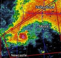
Follow the yellow brick road?
-
I totally didn't just make that up. It's an official term. The AMS knows all about it.....


