

PivotPoint
-
Posts
714 -
Joined
-
Last visited
Content Type
Profiles
Blogs
Forums
American Weather
Media Demo
Store
Gallery
Posts posted by PivotPoint
-
-
1 minute ago, Always in Zugzwang said:
Oh, hello there, pot!!
I have never moved a post (don’t have the capability). So your reference makes no sense lol.. confused face
-
49 minutes ago, mappy said:
You’re more than welcome to go enjoy this threat somewhere else.
Already moved? Why don’t you move your banter???
-
-
 1
1
-
-
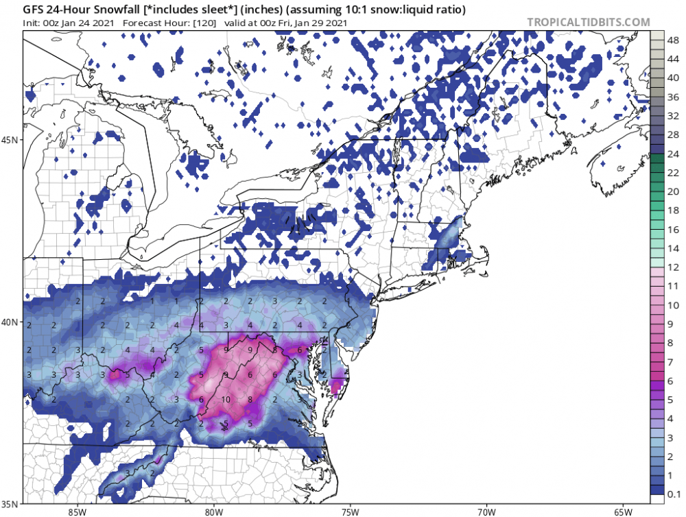
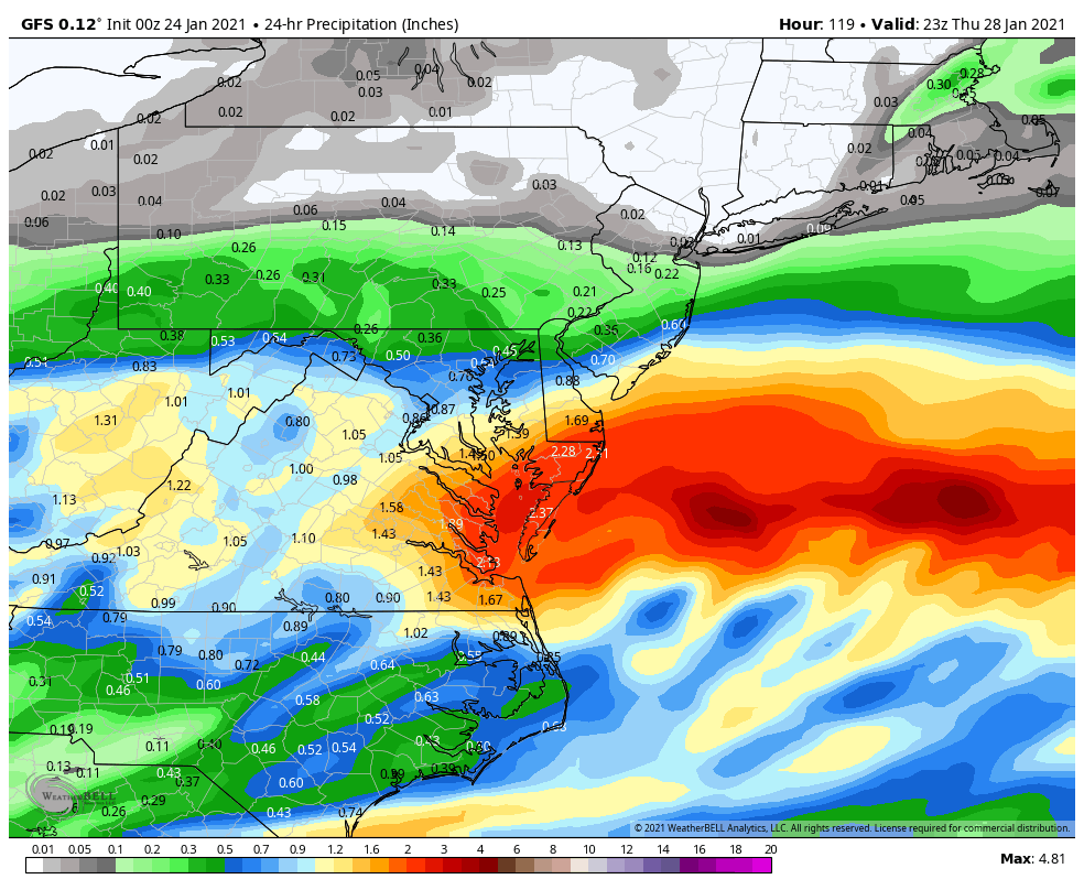
Looking at the latest nams tonight I see dc region getting another 2-3” from this tomorrow.
700mb has improved and the easterlies tomorrow are now more on par with how we receive our ccb snows from a pivoting lp. There’s also good water vapor transport and ample moisture to our west and nw, suggesting when the ccb consolidates we could be on the tail end of banding that sits for awhile
-
1
-
 2
2
-
-
31 minutes ago, clskinsfan said:
Addition.
Doesnt
It does actually. 1pm on so cut that in half
-
 1
1
-
-
1 hour ago, Bob Chill said:
I'm def busting your chops but only because it's going down the bad way. I read a fraction of the analysis posts last week but on Tues I was surprised how different you and I were thinkng when I tuned in to lurk. I kept looking at the setup and thinking congrats pa/nj/nyc and consoling my yard's feelings. I remember looking at a euro run (dont remember what day) and there was literally no snow in the areas I figured the jackpot was headed for. It intrigued me very much but at the same time I was still pretty sure that the crush zone would gravitate to where it always does.
Your analysis is always sound and solid like 100% of the time. I just didnt believe for a second that NMD/PA/NJ were going to get fringed. Opposing forces always seem to let up in the short range. I was really hoping we'd get to the short range with CPA still north of the super heavies that pump eastward off the ocean NW of the low center. The second the drift towards that idea started I dropped the idea of 12+ for my yard and set the win bar at 6" (ignoring my mental hard drove of memories). 6" is a solid # for any nina hybrid in DC metro. Especially when the multi year struggle is real. It just another example of how climo is often more powerful than NWP supercomputers
It’s funny you say this, I actually felt very similar 4-5 days ago. You articulate one of my concerns very well — which was the typical Jackpot spots were underperforming and that the variance between model runs wasn’t waffling in a way that screamed dc-nova-md banding. I personally thought the manner in which the transfer happens and the low positioned itself seemed to lend itself to later (hence more NW) development and the ccb would be to our NW/NE.
However, it’s touch and go around these parts now. If you naysay snow too much around here you get axed. Is what it is. But I like the ridge building my out west through the period and recycling of some of our blocking to the north. Our cold source is much better than 4-6 weeks ago. I say we definitely see some good model runs coming in the intermediate, perhaps
-
4 minutes ago, MillvilleWx said:
Not saying much. If the NAM is remotely right, it will be a pretty large fail with the rest of numerical guidance. Hopefully it's not on to something for everyone's sake. It's pretty crap until almost the PA turnpike
Well at least we have history on our side, in that the when the nam is solo it usually flips. I like at @Bob Chill comment on the transfer possibly being an issue for meso’s to handle such a complicated transfer. Either before or after that is good for frontogenisis and banding, but the middle of this process sometimes leaves them bewildered. I mean, one meso (rgem) has 30+” and the other has 11”, lol. Someone’s not right
-
1
-
-
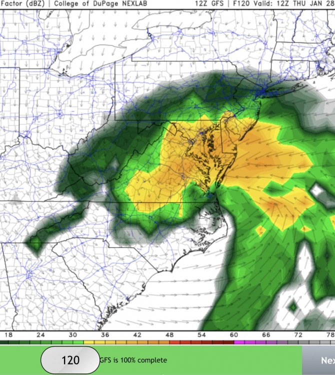
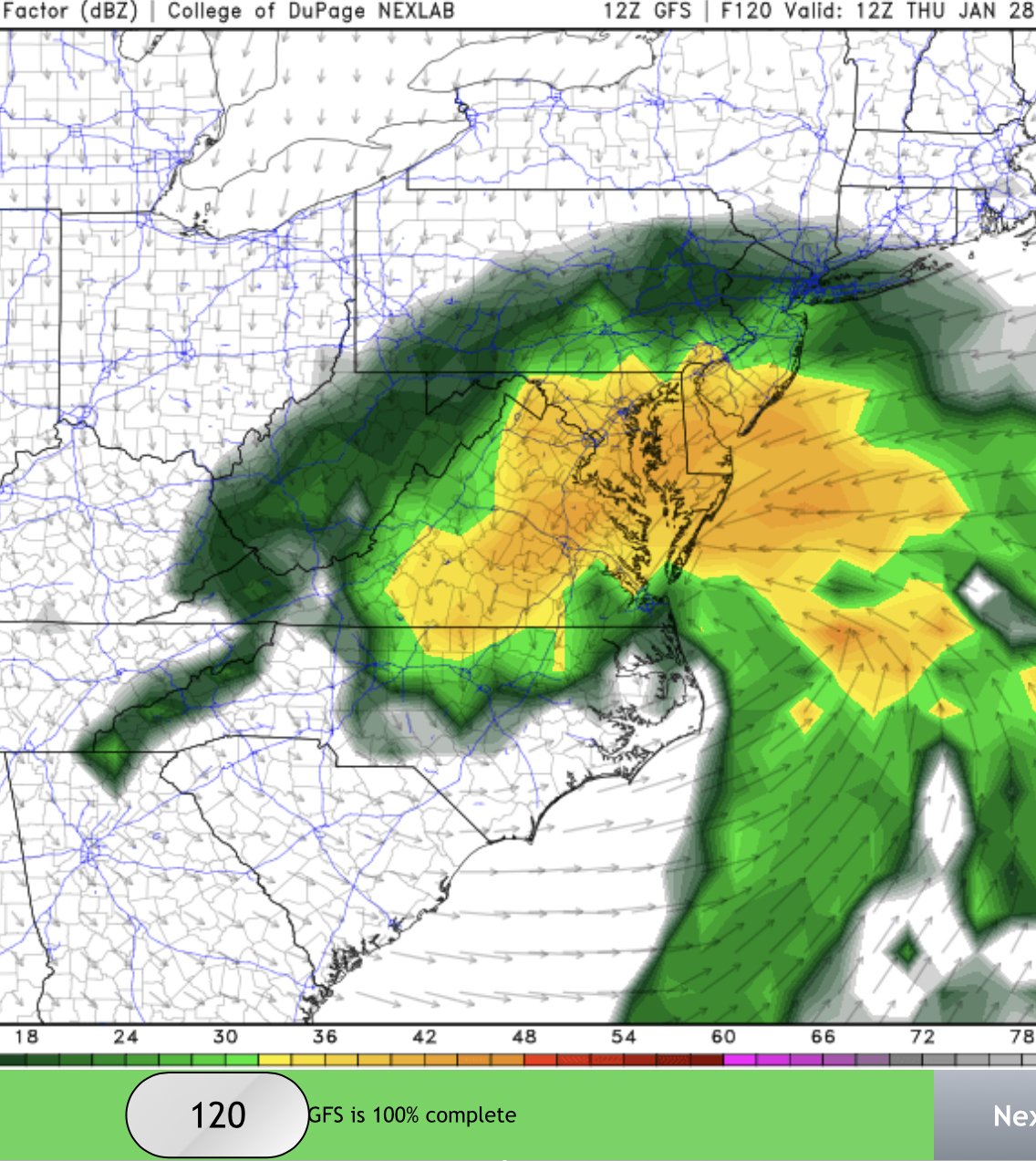
Just now, JakkelWx said:
.png.c903734ca7116b2dcebe3401f5a92cb3.png)
Hello 2-3” per hour rates. Hope you guys get crushed. Good to see chill. He’s the man @bobchill
-
3
-
1
-
-
5 hours ago, Wentzadelphia said:
It’s because the h7 low keeps trending N imo.
It’s also the trough taking its sweet time to tilt negative. If it ticks earlier or quicker the best lift will reorganize a little father SW and we’re in business on the tail end of the CCB.
Unfortunately (like many times) just north of Baltimore and and Phillies area seem to be the sweet spot for deepening and cyclogenisis.
I was also a little disappointed over past 2 days on the WAA thump. Those can really deliver here and can hold on sometimes longer than anticipated. That’s not as robust as it was 48 hours ago.
For me though.. I’m all good. Sitting on plane at the moment in bound to Jackson Hole. It always snows back in dc when I leave during the winter. 09/10 was a direct result of my 6 week absence. So you’re welcome
-
1
-
-
4 hours ago, psuhoffman said:
I would say the EPS supports the op...more then I expected


Seriously the south trend can stop RIGHT THERE!!!!!
That’s a great mean this far out. Need some consistency over next two days but having euro woofing for us is no small feat!
-
I think some possible good news rolling forward is the cross polar flow I’m seeing on the mid-long range gfs. Our blocking breaks down a bit and trough drops in out west. However, I look at the timing of a lack of Greenland blocking coinciding with a -PNA as possibly a good thing. If we can indeed recycle a block, it’s just a matter of time before we get a transient +PNA. With a colder source region and (hopefully) higher heights in the NAO domain, with shorter wave lengths approaching maybe we get the SS to become more active. I’m liking finally getting cold on this side of the northern hemisphere as we approach February and March which can be dynamic and moist.
-
4 hours ago, psuhoffman said:
I don’t think that tpv is the issue. It’s behind the trough axis. It’s close but so long as it’s behind it’s not compressing that much. It’s not helping unless it dives in behind and phases though. But the bigger issue is the spacing (or lack of) between the waves off the coast and Thursday’s storm. The ridge to the west is too close also.
Yea, I agree but it’s still discouraging. I mean, yes the ridge axis out west isn’t ideal and yes, there’s some interaction with the departing storm (not ideal). But I feel like we had enough ingredients that a moderate event was possible if we got the right track. That’s the annoying thing, it’s not an awful evolution but the result is a miss.
I do think though that if the TPV isn’t phasing or helping to sharpen the back side of the trough, then it’s hurting.. not helping, imo
-
1 hour ago, psuhoffman said:
I took issue with your reason not the prediction. The high location was a result of other drivers not a cause. The compressed flow in front in the Atlantic and the amplitude of the wave are the real issues. The wave needed to be stronger or the flow more relaxed in front. Some combo. 2 days ago for a bit those things were trending our way across guidance. Since they have gone the other way.
My rationale two days was either a) storm is more progressive (weaker) and we Chet light snow but perhaps better temp profile (maybe) or b) it’s wound up and we get more dynamics and qpf. The reason we’re failing is confluence to the north created by TPV. I mentioned too much confluence and we get no development and southern track. Pretty sure that’s close to what’s happening. I dunno
-
I think it’s probably ok for me to say it’s likely this will slide south of us. Two days ago when I said it I was chastised big time but unfortunately my fears have come true. I hate that euro is usually right, ugh
-
7 hours ago, LP08 said:
 7 hours ago, PivotPoint said:
Why is it that TT looks like this... WB is way better. Must be the algo it uses. Huh
 7 hours ago, Cobalt said:
GFS is not gonna get a handle on the snow maps even with Kuchera.. using a precip map shows that yeah its pretty juicy for many.

Yea, but what I was getting at was why does the snow map on the 24hr WB look different than the snow map on TT? DC on WB is completely different. So it has to use a different algorithm
See maps above yours
-
7 minutes ago, LP08 said:
Why is it that TT looks like this... WB is way better. Must be the algo it uses. Huh
-
1 hour ago, Weather Will said:
WB Can snow maps 12Z v 0z, again going wrong direction.


If this adjust back south I wouldn't be surprised, but if it also did its usual NW jog inside 72 that wouldn't surprise me either. I think this whole setup is mainly predicated off of what strength and timing of confluence we'll have as the SW digs. Too much confluence and track is south but temp layers are better. Too little and we get ptype issues. Very tedious setup
43 minutes ago, MN Transplant said:I know I’m late to this as we wait in the euro, but that precip shield, that wind direction, that low location, the date, and then you drop that it is 37/36 at DCA. Unreal.
I was thinking the same exact thing today. I guess its a combo of warming background state and the main driver this season (Nina) leading to PAC air intrusion to our cold source. That's my simpleton guess I suppose
11 minutes ago, psuhoffman said:The h5 track is perfect. And i would say it got half way to what we need wrt amplitude to get a nice snow event from this. The h5 dives from Chicago through Ohio and across VA it just doesn’t close off in time for us.

Doesn't that H5 track seem a little flat to you? I would think we'd want the base of that trough rounding a little quicker and titling negative a little earlier to allow for dynamics to take over given our moderate airmass. I know its a tight rope -- if it tilts negative too quickly we have track issues. But I feel like we need excellent dynamics to deal with our ptype issues. I fear if this is not geared up we all fail, vs. rain to dynamic rates with good back side ccb.
-
 2
2
-
-
4 hours ago, Weather Will said:
WB OZ Euro, GFS Can 7am Th


If you blend all three were in good shape.
-
1 hour ago, JakkelWx said:
12z EPS.. yeah it doesn't look good. Too far south. The model with the overamped bias is the furthest south. Lemme tell ya folks, I hate to say it, but this probably isn't gonna end up how we want it.
Didn’t you just give me flack for saying this, like, 6 hours ago lol.. come on man
-
24 minutes ago, psuhoffman said:
@PivotPoint I am sorry I was harsh with you earlier. Something happened that has nothing to do with weather and I took my frustration out on you. You didn't deserve that and I am sorry. I should have explained my meteorological points without the unwarranted personal attack. IMO the representation of the high is an effect of the amplitude and latitude of the trough not a cause.
No worries -- and I appreciate you saying that. I consider you one of the best (if not the best) poster on here so I was a little like "???". But it's all good.
Oh, and gfs looks much better with a little better heights for our ridge out west and better high position/strength -- does wonders for our storm chances. Here's hoping that my southern track idea is crap, and well get hammered with 12+ and rates -- I love me some good rates.
-
1
-
-
1 hour ago, JakkelWx said:
I mean you should probably check his post history.
I mean, go ahead. Not sure what you're referring too? I have woofed for a good period twice and been a naysayer for three individual threats that didn't materialize. In truth, I think I've done pretty well this winter. I try not to weenie-out like many in here. Sorry about that
-
1
-
-
49 minutes ago, psuhoffman said:
weren't you complaining there was no high like that for the last storm...and now this one that is the reason it wont hit. Guess you are consistent with your character at least.
Not sure what you problem is, however, having a high or not having a isn't a binary choice -- as you know. Its not that I prefer to have a high or know high. I just think the location and strengthing in its intensity and placement hurts the amplification. Sorry, I'm not wish casting -- I know that's what gets rewarded in here.
-
This one is going south. 1045 banana high strengthening with each op run. The ensembles look ok but still mostly signal northern va/md as the top of the precip shield. The trend this winter has also been, imo, for waves to trend a little weaker than modeled in 5-7 day time frame. This one will unfortunately probably do the same and with little amplification and a strong wrap around high to our north... this ain’t the one
-
1
-
 4
4
-
-
14 minutes ago, PhineasC said:
It's not that big of a deal. Get a grip.
The Mid Atlantic mods tried the heavy handed approach by banning all banter. The stuff just starts appearing in the weather threads instead. This thread is like a crazy house to keep all the nutty thoughts contained. No one is forced to read it.
Yea, I'm in the Atlantic forum and it sucks. I follow this forum because I ski in Vermont -- so I follow PF and others reports in the NNE winter thread.
The mods in the mid-atlantic sub are so high strung. If you even barely whisper something the don't like you get points or something to your username. It's over the top. The new England forum has always been (for years) way better and also a place where you can go a little off topic, and it's funny to read sometimes. Like I think Damage of Tolland is hilarious. He's the new England "Ji"
-
2
-
1
-
1
-


February Banter 2021
in Mid Atlantic
Posted
Lol. Coming from ravensrule.. talk about a pot