Cold January with Notable Lack of Major Snowfall Poised to Continue
Frigid Arctic Chill to Arrive on the Heels of Slight Snow Chance Sunday Night
Although the month of January has evolved somewhat colder than anticipated thus far, the chilly temperatures have not translated to much in the way of snowfall.
This was not entirely unexpected given that the Eastern Mass Weather Winter Outlook called for most of the above average monthly allotment of snowfall to come between January 21 and February 4th, however, there is a considerable amount of doubt as to whether that will in fact be the case.
Frigid Onset to Second Half of January Largely Unaccompanied by Snowfall
The latter half of January looks to begin in much the same manner that the first half evolved, with the exception of the fact that the airmass early next week will be the coldest of the season thus far. The combination of west coast ridging and blocking within the NAO domain will send the polar vortex on yet another journey southward during the coming weekend as it descends out of James bay and into southeast Canada. At the same time, a weak wave of low pressure will pass offshore on Sunday night out ahead of the leading edge of the arctic airmass.
While the bulk of the precipitation will remain offshore, it is not out of the realm of possibility that an inch or two of snowfall, perhaps up to 3" in some localized areas, could fall over especially the southeastern third of the region before it moves away and the arctic siege begins on Monday.
Thereafter, the cold will moderate thoroughot the latter half of the week as the vortex begins to lift away over the Canadian maratimes.
Then the final third of the month will represent a period of transition, as the polar blocking relinquishes its grip and the Pacific blocking reasserts itself. This will present an opportunity for a more significant storm system, as is the case with any period of mass flux.
High Latitude Realignment to be Accompanied by Latter January Storm Possibility
The expectation last fall was for the month of January to predominately feature plenty of high latitude blocking on the Pacific side that would be accompanied by a strong polar vortex, and thus a dearth of blocking over the arctic. However, while the polar vortex has in fact been appreciably strong, it has remained fairly uncoupled with the troposphere, which has allowed blocking within the NAO domain to remain rather prevalent, regardless.
This may ultimately prove to be a case of delayed rather than denied, as there are signs that the appreciably strong polar vortex will begin to grow more coupled from the stratosphere down through the troposphere. What this will entail is a reconfiguration of the pattern in that the arctic will begin to neutralize (rising AO & NAO), while the greater heights reconfigure from the Atlantic to the Pacific side (descending EPO/WPO, ascending PNA). A hemispheric realignment of this magnitude will represent the type of mass flux and teleconnection modularity that will enhance the likelihood of the development of a major winter storm. This is evident on the Atlantic side.
And the Pacific side between approximately January 23-25.
While this is in accordance with the January 21-February 3 window identified last fall for a heightened risk of a major winter storm, ensemble support continues to be relatively meager, and a track out to sea remains the most likely outcome.
Thereafter, the pattern moderates somewhat over the final third of the month, while also ostensibly becoming more conducive to increased snowfall throughout the forecast area.
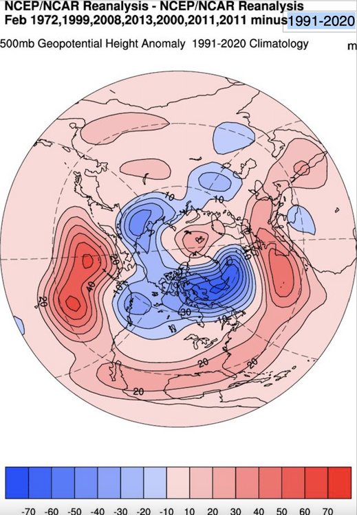
However, this does not appear to be a favorable pattern for major east coast snowstorms, and the similarities of the pattern thus far to some seasons that have managed to largely avoid snowfall across the area with surgical precision can not be denied.


 This event appears to have a CJ/CF aspect to it, which is why you see the subtle screw wedge in the MRV area. I buy that.