Bob Chill
-
Posts
36,402 -
Joined
3 Followers


About Bob Chill

- Birthday July 15
Recent Profile Visitors
23,306 profile views





-
Agree and very excited for it. I am soooooo sick of drenching humidity when working outside. This has been the worst summer for that in my life. Last summer the first half was just brutal but things switched up by August and the second half was very reasonable. This year was door to door unrelenting down here. I'll have to check anom maps but my area has to be +5 or something like that. We had a ton of lows in the low 70s and thats not normal. Usually we get into the 60s even when it's 90-95. The relentless humidity made tough to get pleasant nights after a 90+ day. It seems like this current storm sets things in motion in the upper levels to get some amplified deep continental cold fronts with blocking above to lock HP to the north down. And it could have some staying power where strings of AN days are brief and beautiful fall weather dominates overall. Time will tell but I feel pretty optimistic that's where we're heading. ETA: I checked temp anomaly plots and it's only +2-3 for summer. Seemed a lot worse. Must be the high humidity making it feel terrible day after day after day lol
-
Can't remember how long the Siberian snow thing has been around but its been at least 12-14 years now. Iirc, Cohen has busted on winter forecasts a good bit more than got it right. Based on that statistic, his latest post is actually a net positive for winter snowfall chances.
-
Bad miss down here too. My only measurable rain was an hour shower 5-6pm yesterday. Nothing since. Next couple days look more promising but being wedged in will keep a lid on anything convective. 2-3" is prob off the table. Lakes remain thirsty and very low
-
So we're (over)due then. Boom!
-
It is kinda uncanny in the MA around Christmas. It can be cold AF the week before and it still find a way to be warm during at least part of the holiday week. Especially xmas eve or day... lol. Christmas 2009 was the least memorable and kinda sad white Christmas I've had. Watching a 24" snowstorm just 7 days prior get literally nuked with fog and rain was a little depressing. And we rarely get a white chistmas. Like I cant even remember the last legit region wide one. But I can sure remember a lot of unseasonably warm ones haha. The WDI index has been screaming for a white Christmas for years but for some reason.... we never even get close. Often not even a frosty morning that you can squint and pretend.
-
Idk man, isnt that the most typical outcome here? 80s and 90s were no different in that department. Plenty of punting in the majority of those winters. If anything, the best 10-15 year stretch in my lifetime was 02-03 thru 2015-16 and there was plenty of stench mixed in between the truly good years. Feast or famine and lots of boring stretches is the MA base state for as long as I've been alive lol. Even the 70s werent mind blowing in the snow dept. Deep cold at times was the big story. Not prolific snowstorms. 2013-2016 was the best 3 year stretch in MA history since the 60s imo.
-
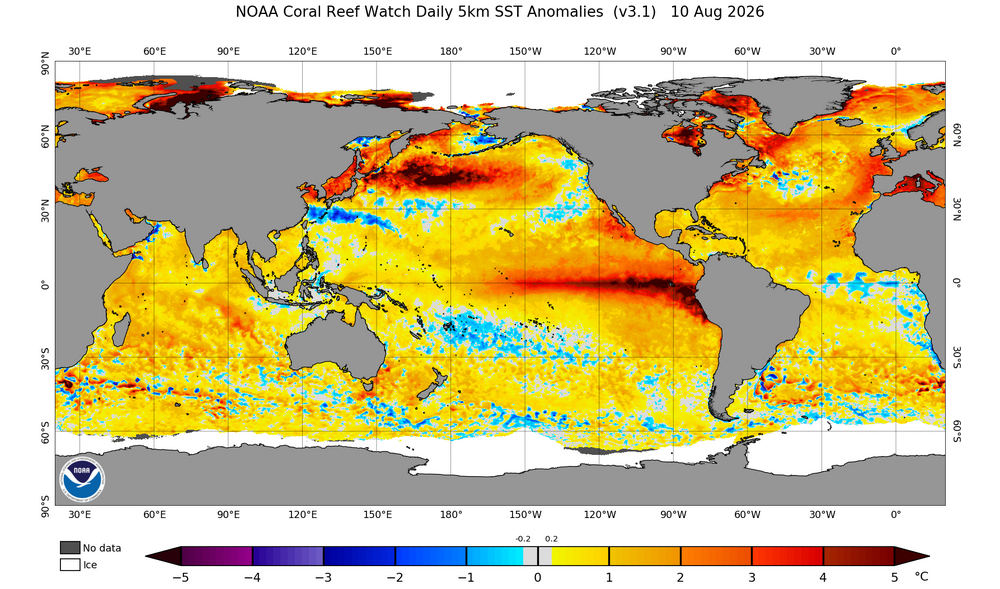
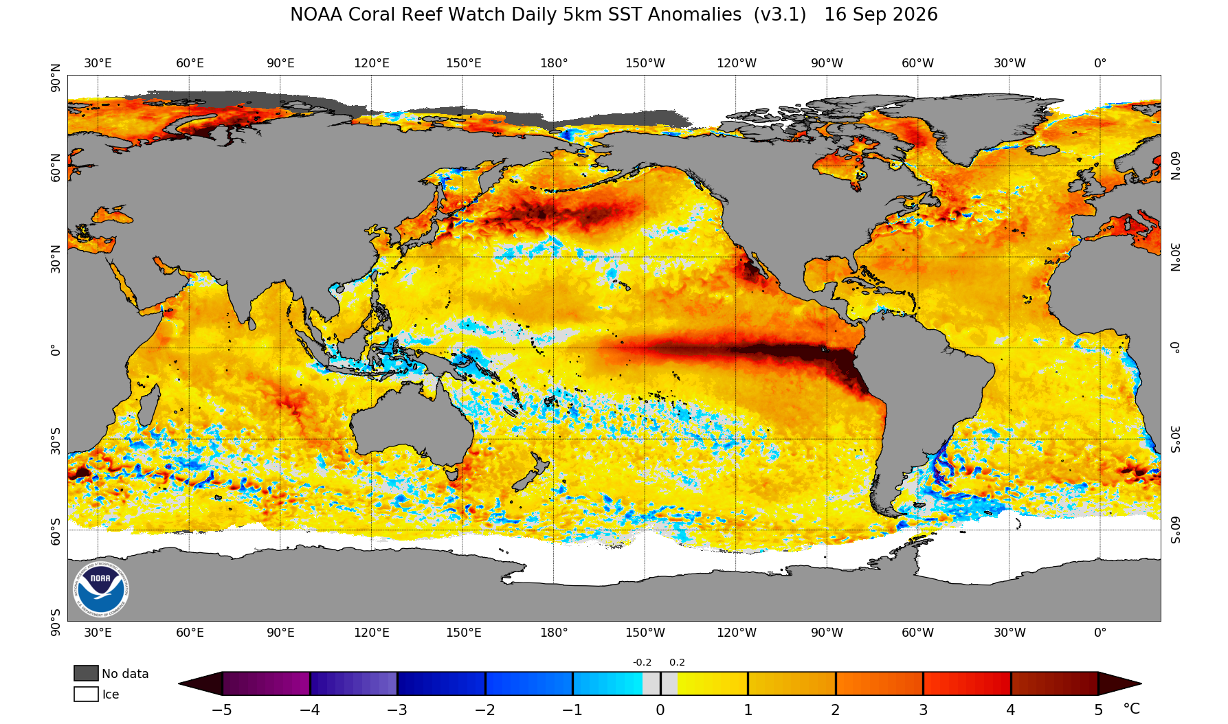
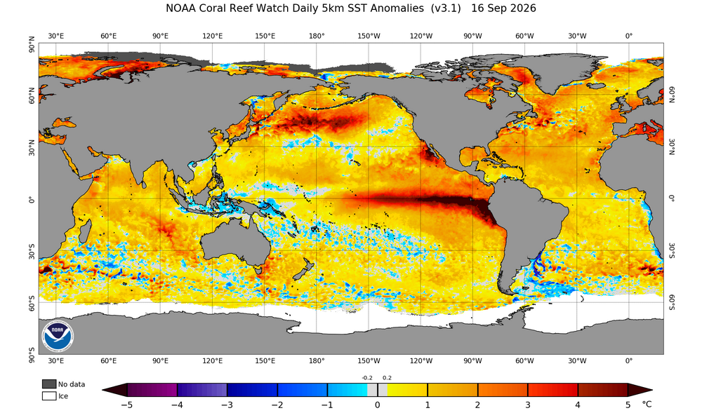
Just looking at the real time Pac ssta plots makes it really hard (for me) to make a case for a remotely cold December. PDO index #s have trended less hostile but thats only a numerical index.... the visual of the Pac is quite hostile still and it's a long ways away from what we consider a favorable enso/pdo combo.... There's a lot of rippin deep red where we want anything but lol As fall progresses it should continue to cool and reconfigure towards at least a semi normal Npac during a Nino but its hard to ignore how ugly the Npac is right now. Its hard to imagine a favorable pac pattern setting in quick for the Eastern conus. This is one of the main reasons I think the Dec CFS idea makes sense.
-
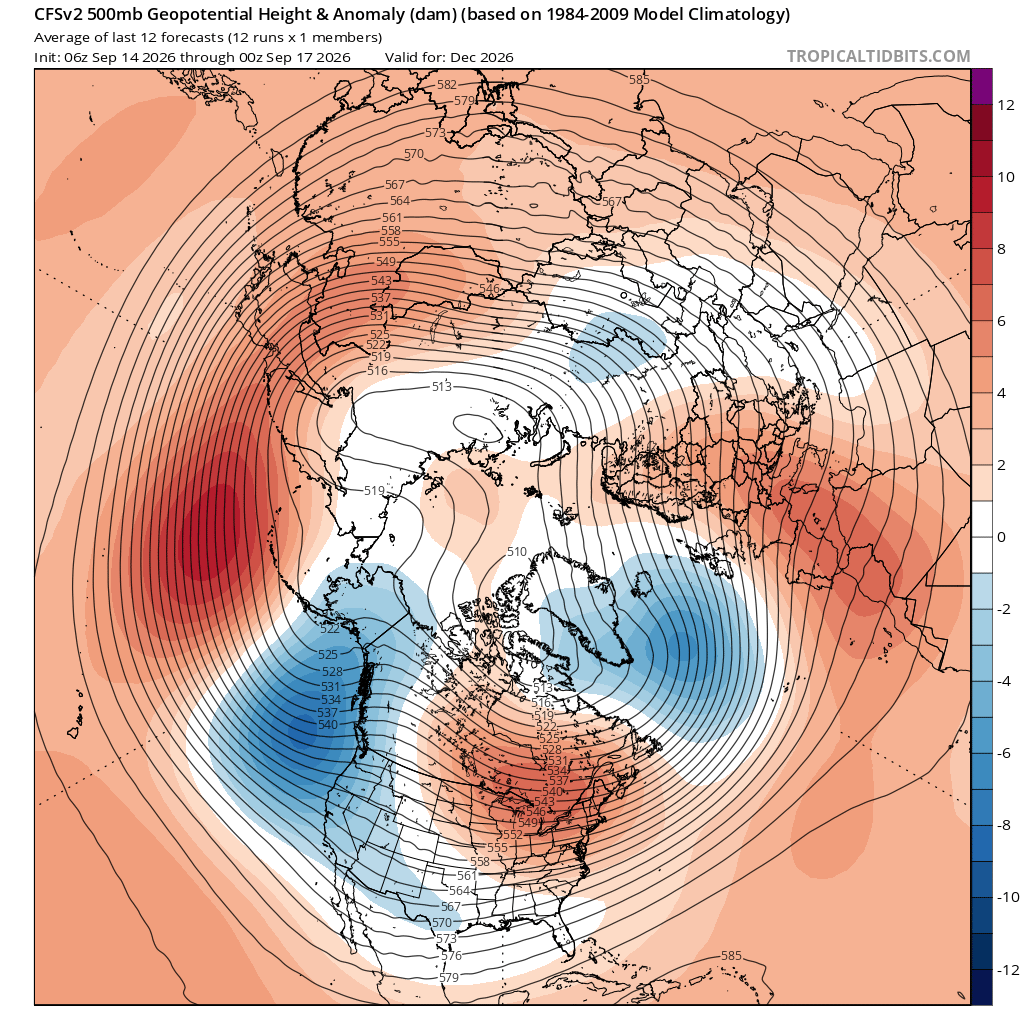
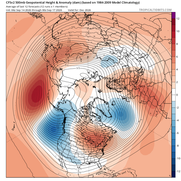
Latest CFS December won't make many friends in the east but this type of configuration makes sense to me as winter gets underway. Imho, a fast start is unlikely no matter how the hemisphere plays out in real time. A deep trough off the west coast and Pac overwhelm in the east is a very real possibility as the winter season gets started. I'm not sold on this look or anything the CFS puts out in general lol but I also wouldn't be surprised if some version of this is how Dec looks.
-
100%. Strong ninos tend to run on the mild side but they also favor decent qpf makers and good storm tracks for our specific region. A good track can't do it by itself though so now we're drilled down into a level a detail that can only be wildly guessed at and not predicted until much further down the road. East based and basin wide ninos don't "eliminate" cold air in the east when it matters and there is no reason to assume warmth will completely overwhelm at this stage. I feel pretty confident that the AO will not be hostile and is more likely to be favorable than the opposite. December is important there. Even if it doesn't help during December, a solid -AO in December often translates into a -AO in Jan and/or Feb. NAO? Beats me. Fickle beast... lol I don't see anyone around here banging a big snow drum in the MA region. Cautiously optimistic until proven otherwise is a fair take imho. The only thing I feel pretty certain about is this winter will not be as cold and dry as last winter. Easy call there.
- 829 replies
-
- 17
-

-

-
Yea, cpc uses 1000mb surface pressure patterns for its numerical index calc which throws me off at times too because we always look at 500mb height progs. Surface pressure does correlate to 500mb but things get muddy in that dept. Some of which is due to domain space size. I dont worry too much about the numerical index when 500mb looks tasty lol
-
It's really hard to guess specifics but I look at it as an indication that the longwave pattern might not be typical. The large scale ridge/troughs may not park where they normally do on average. A key feature with ninos is a deep trough south of the Aleutians and a downstream ridge that blocks strong pac maritime flow into the conus. That's half of the split flow we look forward to with ninos. Screw that all up and things dont look as tasty. I'd sure feel better seeing a more typical +PDO ssta configuration given the strength of the nino. Not saying i expect disaster. Just not crazy bullish on the Pac as a whole.
-
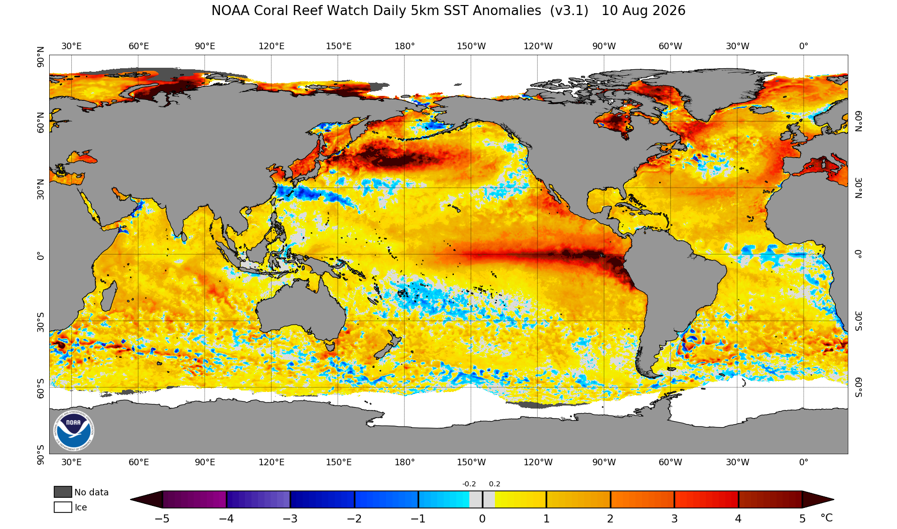
It's an "easy" enso setup to make some decent predictions if you just look at the Nino regions. Where I'm getting hung up is the Npac. There is so much warmth throughout the pac basin that it makes me far less confident predicting standard strong nino conditions. But given the strength of the nino, its hard to bet against a wet southern stream. Its still only August but if the Npac/pdo regions continue to be the opposite of what we really want to see, my gut says this winter will do some weird things that few expect/predict. The pessimistic side of me thinks the pac will overwhelm north America and it will be warm and wet with few chances at good snowfall even to our north and west. The optimistic side of me says we're in a long term HL blocking period and even the EPO will punch cold to very cold air into the conus with a suppressed/favorable southern stream. Meaning the winter could be unusually cold east of the Rockies for a strong nino. I would be pretty funny if its a dry winter though. Maybe the southern stream cuts well west of us or stays south of the gulf coast lol
-
Mushrooms are going nutz down here too. Recent rain and consistent high humidity are the cause. Especially the high humidity. It's been stupid humid down here for weeks. Looking so forward to the first legit Canadian front. It's been a tuff summer working outside
-
Lol. Down here, any equipment owner/operator is making well over 6 figures. Going rate is $800-1200/day depending on complexity. Forest mulchers are $1,500+ but that kind of work is dangerous and hard on equipment. Fun to watch though haha
-
Basically both. This is pretty wild for August. PDO region is a literal dumpster fire. You could cook ramen by the square mile. I dont have many concrete thoughts about winter. Seasonal guidance is basically default enso climo but the Pacific overall is anything but normal or default. But it's only August and much will change. If seasonal guidance has the right idea with the AO/NAO, winter will probably produce but the anomalous nature of enso will prob produce anomalous patterns. When and what is above my pay grade