Search the Community
Showing results for tags 'severe storms'.
Found 11 results
-
Since nobody else hasn't started a thread on this potential event across the Gulf States, Mid-South, and western portion of the Southeast started today through early Sunday.
-
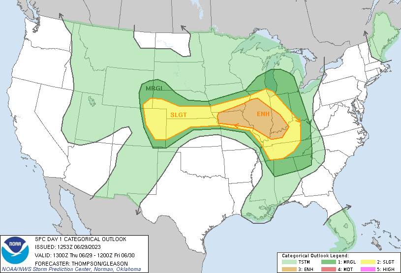
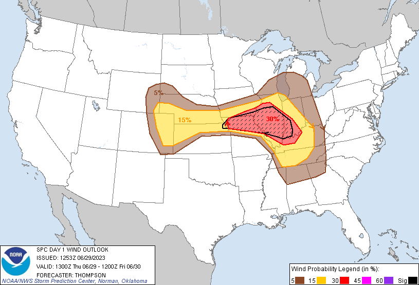
SPC has introduced a 30% hatched area for wind across N MO, Central IL and SE IN. There are already watches out in Missouri. Destructive MCS/possible derecho becoming increasingly likely today.
-
 Still looks to me as posted by SPC yesterday..most gusts under 40 knots but per their slight risk area, added this thread. HRRR suggests greatest threat of SVR that crosses into our subforum should be I84 northward. Please follow SPC outlooks/watches and NWS statements/discussions/warnings/reports.
 -
123PM Tuesday (7th): Raised iso max amount to 3.5". This thread will serve as OBS for this event as well. 528A Tuesday (7th): added possible iso SVR to the tags. This per some of the guidance with CAPE & decent wind aloft plus the newly added SPC MARGINAL risk across our area. No other changes at this update issuance. Added some information graphics from the NWS issued prior to dawn this Labor Day 2021. The Marginal risk for Wednesday-ear;ly Thursday and it's discussion, plus the Mid Atlantic River Forecast Center 6 hour Flash Flood Guidance (use legend for 6 hour amounts needed to begin flooding). Have checked the available River Stage ensembles and they do not seem to respond with rises, but undoubtedly a few small streams will respond with uncertain to predict rises. 00z/6 EPS rainfall is higher (almost twice) than the GEFS. The EPS does not go into the automated River Stage ensemble response guidance. NWS modifies this guidance for their official river stage forecasts, which generally officially publish daily around 10A-11A. Periods of showers Wednesday into Thursday, with an uncertain timing end to the showers and uncertain location of the max rainfall axis, which could reach 2". Just too uncertain at this issuance time to confidently narrow the range. Intensity will determine amount and runoff response. This WPC discussion from predawn Labor Day was added below. ...Northeast... The progressive shortwave trough and its attendant surface low and associated fronts mentioned in the day 2 period will be tracking through the Great lakes and Ohio Valley region into the Northeast. Additionally, there will be a warm front lifting through the Mid-Atlantic states. PW values will be increasing from as the front approaches from the West, reaching 1.25 inches (+1 standard deviation from the mean) by 06/12Z on the 8th. Much of the Northeast will be in an area with broad forcing for ascent. Initially, low-level winds will be westerly near 15-20 kts but will then become southwesterly, increasing to 35 to 45 kts by 6/12Z as the cold front approaches the region. A fairly narrow axis of QPF is expected to align along/ahead of the cold front from West Virginia to Maine, over a large portion of the region that was hit hard by torrential rains from Ida within the past week. These areas are still recovering therefore any measurable rainfall will have the potential to aggravate ongoing flooding. A Marginal Risk area for excessive rainfall and flash flooding was raised, spanning from eastern Pennsylvania/northern New Jersey to north-central Vermont.
- 50 replies
-
- 2
-

-
- flash flooding
- river flooding
- (and 1 more)
-
Nowcasting the the frontal boundary period of strong thunderstorms w heavy rain, lightnng strikes, hail, mainly along and south of I80 this evening. NYC seems to be on the north fringe but worthy of monitoring. There may be a second batch after 1AM Tuesday?
-
Featuring Severe storms this thread though with wet ground cannot rule out isolated FF where excesses have occurred recently, especially ne NJ...but PW max around 1.4" and a bit faster moving, especially Wednesday, limit the FF potential. Follow modeled (FV3, NAM3K, HRRR, SPC HREF), NWS-SPC outlooks/warnings/stmts and your own takes, obs. TT up into the lower 50s tonight and Wednesday early afternoon. Wind fields a little on the lighter side today so believe svr risk from a dying line of esewd moving sct heavy convection is NYS/CT, maybe with a remnant thunderstorm down to I80-NYC around or after midnight. Should have a refire Wednesday afternoon but where does it grow large enough to be SVR? Probably I95 corridor eastward. NJ coast may end up the most favored area on Wednesday. Check for any changes in the SPC day 1 and 2 outlooks which at 6am has marginal upstate NY today, and then our area Wed.
-
Please follow NWS (SPC/local offices) for additional information on the late Thursday afternoon-evening SVR threat. Confidence on SVR late today is less than a CAA wind event for late Friday. Used HRRR/EC/3KNAM for main guidance, Richardson # projects strongest wind transfer of a descending jet Friday evening, after sunset. Whether that occurs? However lapse rates do increase substantially with the arrival of the cold pool aloft allowing opportunity for damaging wind gusts late Fri-Fri eve. No time for graphics-please follow up as you think best. This thread should serve as the thread for any damage reports.
-
Topic posted as a cover for the possibilities but this, as of 611AM Tuesday does not look like w widespread SVR or FF event. Please see SPC D1 Marginal Risk and followup's, as well as local NWS discussions, statements and any warnings plus our own American Weather interpretations and observations of any significant storms. Enough CAPE/KI/marginal wind aloft for a couple of clusters of strong storms. Don't like the 850 westerly flow for lots of svr, and the trough appears too close for too much SVR organization. Best chance for se NYS-nw NJ, 1P-7P. Best for s CT/LI/NYC, ne NJ and s of I80 later...3P-9P, then again midnight-5AM. This secondary late night increase is when it may be most favorable for an outbreak of heavy convection and several hours of training with embedded isolated SVR/FF and estimating best location IF this is to occur, would be anywhere on Long Island overnight. (noting several models with much increased convections overnight but mostly s NJ eastward. Could be more interesting up here on LI near the leftover boundary). I wont be updating anything on this topic between 8A-330P. Hope this produces something of interest.
-
Modeling looks terribly slow and ineffective for two bands of convection this evening in NYS/PA. Running much faster. If this is true... parts of our NYC forum, at least se NYS and nw NJ are going to experience a brief heavy shower or gusty thunderstorm between 815PM and midnight and possibly again near 2AM Monday. That leaves us with what for Monday afternoon? I think a pretty ripe environment for big storms maybe even up just N of I80...with interestingly large mid level lapse rates, especially I78 south. Not promising big stuff near NYC but it seems to me modeling (not SPC - check their Marginal D2) is missing potential svr/ff, especially southern part of our forum Monday afternoon 2P-7P. Will rereview how things are going Monday morning around 7A, but for now... it looks like big heat has generated big storms Sunday evening just west of the forum and I think very poorly modeled. If someone has seen a model that is performing admirably in PA/NYS to the Poconos and Catskills, please let us know. 735P/19
-
Good Wednesday morning everyone, Unsure whether this will happen but mass field signals seem to me to flag potential for one or two bands of svr storms racing east in strong low level WAA (and moist too-CAPE, and KI modeled going way up). Early max gust signal of 40+ knot in the EC for 5 consecutive cycles upstate NY and far northwest PA toward 00z/Sunday the 27th. So, I'll just wait this out... see what happens (see if EC is too robust?). 00z/24 GEFS and EPS similar on wind fields 850, 500mb. You're welcome to add on and I'll post the SPC SVR reports image, Sunday the 27th, after 12z. It's possible the heat here on Saturday (90-95F non marine influenced) could be minimized if the storms arrive too soon, but my guess, per modeling seen early this Wednesday June 24, is that the SVR event would occur (IF??) in our area between 6P Saturday and 4A Sunday. If you wish to see any graphics I've referenced, let me know. I may not reply immediately.


