Search the Community
Showing results for tags 'flooding rains'.
Found 6 results
-
 The modeled next powerful storm into the Great Lakes region should add around another inch of rain in 6-12 hours Friday night, possibly causing renewed urban, basement and small stream flooding and probably extending on-going mainstem flooding in the NYCsubforum through the weekend. Maximum south-southeast coastal gusts possibly capped around 50 MPH along the shore Friday night but when the storm gets into Canada, backside westerly gusts might hit 50 MPH anywhere in the NYC subforum for brief periods of time later Saturday into Sunday. So some power outages are possible. Coastal flooding does not appear to be a large threat. Snow-sleet-freezing rain is anticipated at the start Friday afternoon-evening along the I84 corridor bordering the northwest portion of NYC subforum with "possible" short duration amounts generally 1/2-2" mainly in the high terrain above roughly 1000 feet. I84 corridor valleys, probably little or no accumulation. Max rainfall from this storm maybe ~2'? This thread will also serve as the OBS thread for this anticipated event.
- 90 replies
-
- 5
-

-
- flooding rains
- damaging wind? squalls?
- (and 2 more)
-
Another significant weather event is headed our way, about 7-8 days after the last. By the time the first day of winter officially starts, we may see a little snow or ice for the interior and substantial rainfall that could prompt flood and coastal flood statements for our area. Sunday-Thursday "potential pair" of wet events that could eventually change to ice or wet snow, especially I84 elevations Tuesday-Wednesday. Substantial rainfall is outlooked... probably at least an inch for virtually the entire NYC subforum and possibly """isolated 6"""" worst case. Not saying 6" will occur but it's in some of the advance modeling and it could end up over the fish. Persistent northeast winds for possibly up to 4-5 days could be a coastal flood problem. A disturbance in the southwest USA today-Wednesday 12/13 migrates east, ingesting short waves from the northern stream and a juicy one out of the Gulf of Mexico. Then it apparently plods northeast along the east coast. How close the upper low comes up here before fading east is with the traditional uncertainty and TBD, but it will be interesting to monitor. There could be a significant banding signal well to the northwest of the upper low and if that upper low holds together longer and eventually makes it up to the south of LI by the start of winter., it will have produced quite bit of impact here. That is still very uncertain and not a lock. Modeling seen through 06z/13: EC-EPS is basically one and done by late Tuesday, but it even flags interior snowfall, the GEFS is most robust for wintry weather and the CMCE, a slightly warmer model, also has some wintry stuff a little further north of I84. All ensembles agree on accumulations Adirondacks. This is another El Niño event, that is particularly juicy (see FL coast pressure intensity), and has a noticeable RRQ of the upper jet near the Canadian Maritimes (southern-northern stream merge) to assist upward motion. Will there be two events next week? or just one centered on Monday? Title update 6AM Saturday from the original that follows: added Damaging gusts LI/CT. A single or pair of nor'easters Noon Sun Dec 17, 2023 - Thu evening Dec 21. Potential: flooding rain I95 corridor, persistent gusty ne wind driven tidal flooding episodes next week, change to ice or snow interior elevations by Tue morning.
- 489 replies
-
- 11
-
-

-
- flooding rains
- coastal flooding
- (and 4 more)
-
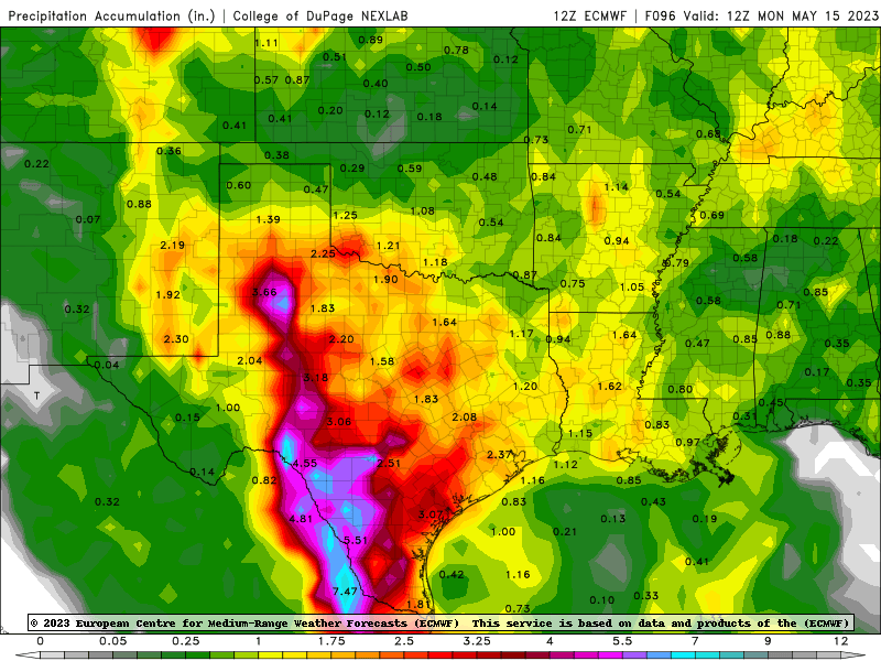
 Some differences in models, but widespread 5 inches along the Rio Grande from the Big Bend to the coast threatens major flood in South Texas and Coahuila and Tamaulipas.
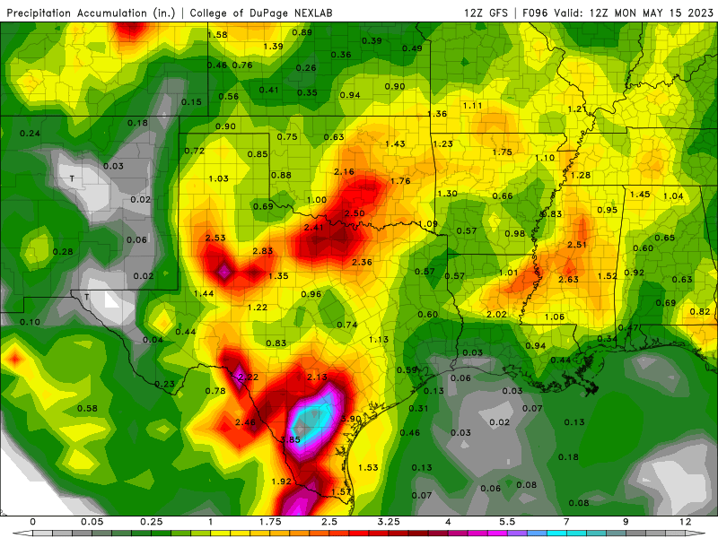
-
The gusty east winds of 45-60 MPH along the NJ and Li coasts early tonight will ease from south to north by sunrise Saturday as the bands of heavy showers and embedded thunderstorms sweep north through the NYC subforum with generally 3/4-2" amounts. Depending on amounts ne NJ might end up with flooding overnight, while streams and rivers that were receding start rising again during the night through Saturday. There should be a lull in the showery weather Saturday morning-midday, but drizzle may occur in some areas. Another burst of showery rains, should develop across the subforum mid Saturday afternoon, except maybe missing to the east of PA. This is associated with low pressure and the approaching sharp but weakening 500MB trough heading east-northeast through the mid Atlantic states. There are questions on how much rain can occur with this second system, the HRRR and 3KNAM tending to be furthest west. It's possible thunder will occur with system as well as instability approaches 0C during the evening.
-
504AM update on Friday (24 hours after initial issuance). Withdrew from the title INDIRECT. --- 333PM Friday about 33 hours after issuance. Changed title to Moderate - MAJOR impacts, tags changed from tropical weather to hurricane gusts, heavy rain changed to flooding rains, RC and CF remain as they were It is becoming more apparent via modeling through the 12z/20 cycle, tho follow NHC, that this storm wants to turn northwest and make landfall anywhere between Block Island to Sandy Hook. Where and intensity? IFFFF Henri still passes east of Montauk, that will be fortunate for LI/CT. Follow NHC, and updated collaborated models and experienced statistical output of Tropical verification. Strongest gusts and largest waves & storm surge should be east of the center on the Atlantic side of the the storm, but beware all the east and northeast facing inlets LI Sound. RC obviously dangerous, and possibly even for experienced surfers. SHOULD BE ZERO casualties due to RC and high Surf. There is enough info out there now that asks us be smart about living safely. Wind: potential from a combination of squall gusts 40 (to possibly ~ 65kt) and preceding heavy rains near and east of the center track, to uproot and snap fully leaved trees, with 'potential' for long duration power outages. Therefore east of the center track, charge your phones, have fuel ready for generators (outdoor exhaust only) and maybe rent a couple of movies since along and east of the center internet connectivity may be lost. TOR (s): maybe? mainly northeast quad of Henri Sunday morning. Rainfall: Looks like 3" near and west of the center of passage, but pockets of surprise amounts elsewhere in the interior? Max by Tuesday in the lingering weakened remnant state??? Maybe isolated 10" somewhere??? Coastal Flooding: dependent on timing with the high of the tide cycles this weekend. This will be a pretty big storm, with varying impacts. Worthy of monitoring updates and being cautious about outdoor activity late Saturday-Sunday. ---- Below from Thursday 5AMish 8/19/21 Follow NHC and NWS collaborated guidance on the path and impacts of Henri upon our NYC subforum. Astronomiically higher than normal tides combined with some onshore flow and building seas should result in pockets of significant coastal coastal flooding this weekend. Presuming the direct path of Henri remains e of LI, we are probably spared a tide cycle of major coastal flooding. Vulnerable regions to typical minor coastal flooding should monitor NWS statements for an event that may be larger than the typical minor events encountered through the year Rip Current: Appears to me difficult to avoid the risk of dangerous rip currents this weekend. What might be good for surfers as exposed Atlantic shores coastal waves build to 6 feet, will be life threatening for most, if not all swimmers. Follow NWS and local official guidance including that of life guards. Heavy rain: The combination of a trough(s) extending northwest of Henri and PWAT nearing 2" again, may develop pockets of intense slow moving showers well northwest of Henri's passage. There could be isolated 3" amounts in our NYC subforum. Henri winds: 34 KT gusts probably remain east of our subforum but follow NHC guidance. 19/457AM
- 1,603 replies
-
- 1
-
-
- hurricane gusts
- flooding rains
- (and 2 more)
-
OBS and NOWCAST as this storm unfolds. Power outages may limit some of our participants from adding data. Be prepared for losing the internet, even if you own a generator.
- 242 replies
-
- 2
-
-
- damaging wind
- flooding rains
- (and 1 more)