

ILoveWinter
-
Posts
1,319 -
Joined
-
Last visited
Content Type
Profiles
Blogs
Forums
American Weather
Media Demo
Store
Gallery
Posts posted by ILoveWinter
-
-
9 minutes ago, kat5hurricane said:
NYC averages 25-30 inches a year. This isn't Atlanta. What we've seen the last few winters is NOT the normal outcome.
True but I think a component of our average is due to above average winters where we get a KU (or two in some cases). Without those, we get these nickel and dime events such as this past Sunday / Monday's event.
-
6 minutes ago, Allsnow said:
Everyone at 2 except the park
lol was just about to comment on that, though maybe they have not yet updated after this morning?
-
 1
1
-
-
6 minutes ago, Bxstormwatcher360 said:
Some gd bursts incoming for the metro per current radar.
Yea this last burst may just get CPK above 1 if not there already
-
1
-
 1
1
-
-
2 minutes ago, the_other_guy said:
it wasn’t a bust at all
Just a bunch of guys talking themselves into a frenzy on a 1-3 inch snowstorm
this was a perfectly modeled, perfectly forecasted, 1 to 3 inch snowstorm.
And as myself and several other posters tried to say yesterday, if you set your expectations for a light snowfall you were going to be happy. And if you set your expectations on a fabricated 6 inch snowfall, you weren’t going to be happy.
It was sort of a bust for many in the sense that most of the models kept on bumping totals up even up to game time. Not an epic bust or anything.
-
2
-
-
Just now, MJO812 said:
I think 0.8
lol wow streak may continue if that holds
-
 1
1
-
-
6 minutes ago, donsutherland1 said:
The 12z HREF 24 hour snowfall for the period ending 1/17 0z:
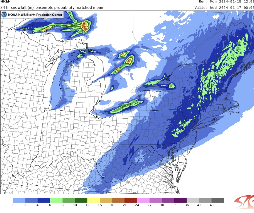
Rare storm where all of the big cities from DC to Boston are in line for similar totals
-
2
-
-
49 minutes ago, jm1220 said:
Don’t be surprised if this trends to crap again for the city east since we normally have these storms trend NW at the end and the SE ridge isn’t modeled too well and often gets stronger closer into the event. And the cold air is really for after this event, not going into it. If we get prolonged easterly wind again near the coast we’re screwed.
Isn't it dropping into the lower 20s and may not break freezing in the city tomorrow?
-
This much pessimism after a bad run by one model at 18z 4 days out from the event? Way too early for that! (or being overly optimistic for that matter)
-
2
-
-
10 minutes ago, Typhoon Tip said:
Lol... certainly no shortage of adventure - if not 'entertainment'...
Yea tracking all the different model runs ahead of a potential snow storm is 50% of why I enjoy them lol. Though living in NYC, it usually ends in disappointment!
-
5 minutes ago, NEG NAO said:
who is even mentioning 4 - 8 ??? Walt says 1 -3 " right now which is being generous IMO
Yea was just responding to a previous comment!
-
1
-
-
17 minutes ago, WIN said:
It's funny how perspectives have changed over the last 20 years or so. In the 80s and most of the 90s, 4 to 8 was considered a heavy snowstorm.
4-8 in the immediate NYC metro would be amazing considering the garbage we've experience in the past few years but yes in the wider context I agree.
-
1
-
-
16 minutes ago, jr461 said:
Many had been saying (but seemed to have stopped) that until this weekend's cutter goes through the models wouldn't really have a credible grasp on how things may play out. Is this still the case?
I'm no expert but I wouldn't say the models are not credible now, only that both the passage of time and tonights storm will of course make things clearer.
-
3 minutes ago, cleetussnow said:
word has it the EPS still has it
Yea we really should only be looking at ensemble means at this early juncture. No use getting overly excited or upset over Ops runs 5-6 days out, especially as we wait for the friday night storm to clear out before we get a better picture of the finer details.
-
1
-
-
18 minutes ago, NEG NAO said:
need the EURO to back off on the amped up solution and still have to consider all of the ensembles - this cold air on the way means business !
How did EPS look? Prob better to look at ensembles vs any op run at this juncture
-
Light to moderate snow in the UWS
-
Moderate snow in the UWS but mostly wet and not white on surfaces
-
-
I'm still waiting for the inevitable "storm looks to be forming further east / colder than modeled!" posts lol
-
 1
1
-
-
2 minutes ago, CPcantmeasuresnow said:
The record is kind of a joke anyway since LGA and JFK both have had 1.0 in that time frame, and so has the Park, they just haven't recorded it, the 0.9 the perfect example.
I'm sure whoever is not doing their job measuring today and tomorrow at the Park will insure the record stays intact. It's a 150+ year track record of ineptness that they wear proudly.
Agreed and as I've posted before, I live near the Park and recorded around 1.5 in multiple locations during one of the storms last year. Issue was that it didn't last long so they may have missed it.
-
1
-
-
Clearly things not looking good for the immediate Metro though I still hold out the possibility of a strong hour or two front end thump that could lead to an inch or so at the Park.
-
1 minute ago, Allsnow said:
Euro has been deadly accurate with that storm so far from 7-8 days out
Of course, it's a rain event lol
-
2
-
-
42 minutes ago, lee59 said:
This is kind of a ridiculous stat for NYC. I believe the streak at Kennedy, La Gaurdia and Newark is about half Central Park. They should use the 2 inch and under which is more realistic. Apparently about the only place in the NY metro area that didn't get an inch of snow was Central Park.
And it's wrong, I live near the Park and I measured 1.5-1.75 (multiple locations) during one of the storms last year.
-
1
-
-
5 minutes ago, HeadInTheClouds said:
Most models have BL temps in mid 30's in NYC metro and Long Island. It's going to be difficult to get significant accums in those areas. Those 10:1 maps are bogus.
Agree. After experiencing many winters in the City, BL temps just don't cut it here - unless there are strong dynamics / rates.
-
2
-
-
Good trends today - especially for those north and west but within the City itself, borderline temps will not cut it for anything but wet roads and some slushy accumulation on grass. Hopefully the trend continues.
Taking this NAM run with a grain of salt though it's definitely pretty to look at!
Snow Friday 1/19/24: is it a period of light snow (less than 2"), or is there a chance of a 5" swath in part of the NYC subforum? Event OBS.
in New York City Metro
Posted
Yes even in the UWS, still a very wintry scene.
Edit: Especially now with light snow falling