

ILoveWinter
-
Posts
1,134 -
Joined
-
Last visited
Content Type
Profiles
Blogs
Forums
American Weather
Media Demo
Store
Gallery
Posts posted by ILoveWinter
-
-
5 minutes ago, HVSnowLover said:
HRRR says a lot of mixing in the city until 1 pm and then things dry up, still not feeling great about this near the coast but we'll see......
it's been all snow in the UWS for almost 30 mins now though not yet accumulating.
-
 1
1
-
-
All snow and coming down nicely in the UWS
-
1
-
-
-
3 minutes ago, MJO812 said:
Euro fail
It would be a fail if the changeover happens after 11 in the city no?
-
Anyone know what the latest HRRR shows?
-
I'm not expecting more than 2 here in Manhattan but i'll be happy as long as there is a period of heavy snow.
-
 1
1
-
-
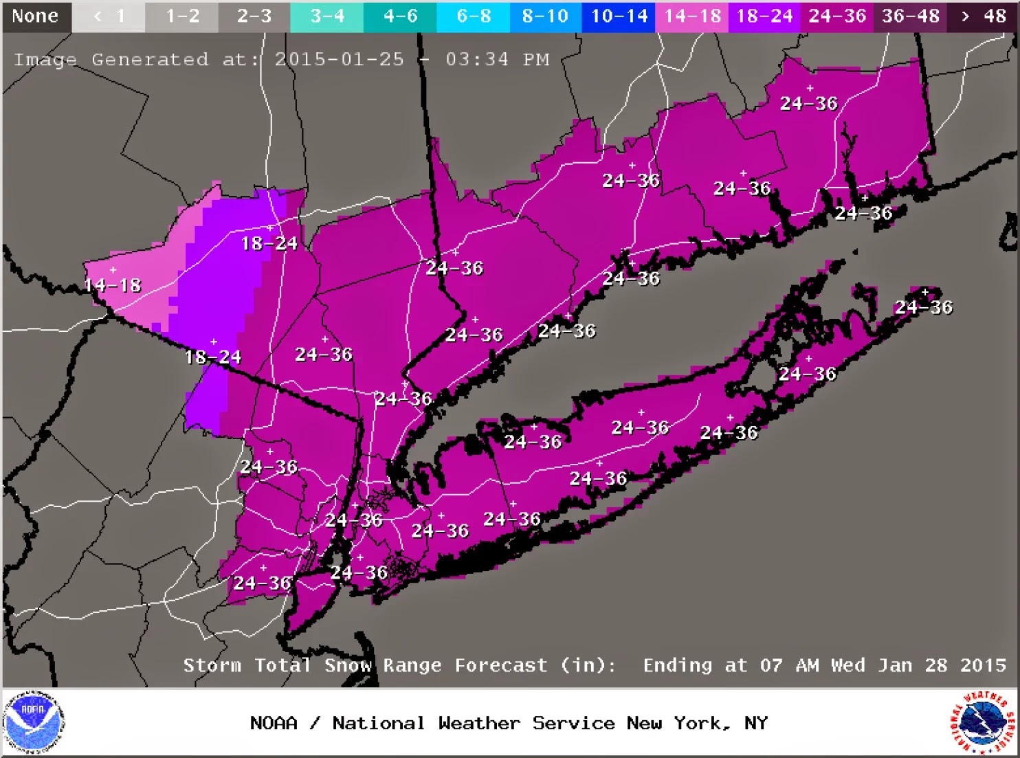
6 minutes ago, HeadInTheClouds said:
RGEM refuses to give in to bigger totals
.thumb.png.96612059547bc6a21ddd7bfc2fa4c493.png)
The RGEM just seems like a weaker/less snowier storm in general. Far less pink hues overall.
-
 1
1
-
-
4 minutes ago, snowman19 said:
Funny how you’re spiking the football already, 24 hours out, it’s going to be funny tomorrow when you get less than an inch to total in NYC lol Watch the models back way off at 0Z tonight. The RGEM and CMC are the closet to reality IMO
It's true that this may not amount to much snow wise in the immediate metro but it wouldn't be because you were right. It's much easier to be a warm weenie and claim a forecast victory in this area as things more often than not don't work out for us in the snow department, espec in March.
-
1
-
1
-
-
National Weather Service still not biting for much of a snow threat in the immediate NYC metro, in fact you've got to get to Orange County before you find an Advisory. Expected accumulation in CPK is 0.6 and the high end amount is 2.
-
4 minutes ago, SnoSki14 said:
I highly doubt it'll be as pleasant and picturesque as he thinks. I see a lot of dangerous weather this spring & summer.
Also late March & April/May will likely have some crappy stretches with easterly flow guaranteed to cause misery.
Yea those back doors can be a rude awakening after a few nice days in a row. The worst is when the front stalls out 50 miles south so that Philly and DC are basking while we shiver!
-
Heavier burst of precip in the UWS so all snow. More of a mix when it's lighter.
-
-
As for us that live near the urban core: from experience, with borderline temps in March (espec if this is during the day) it REALLY needs to come down in order for snow to accumulate.
-
1
-
-
5 minutes ago, LibertyBell said:
No it's not luck, it's urbanization being a huge factor. I've often seen areas south of us have higher totals in late season events.
Yea I'd agree as living in Manhattan for the past 8 years or so, temps cannot be marginal in order for the snow to sufficiently stick (outside of grassy areas though even there this is true to a point). Ideally, CPK should be at 30 or below.
-
1
-
-
1 hour ago, CPcantmeasuresnow said:
For the most part yes. Even Central Park received almost 3 inches despite reporting 1.6, but that's par for the course as they revert back this year to the old days of under measuring.
I can confirm this as I live pretty close to the park and I measured 3
-
1
-
-
10 minutes ago, snowman19 said:
And how do you know that the MJO isn’t being rushed like what just happened this month? How do you know it’s not changing the pattern too fast…..again? Remember when everything had early February torching because they were too fast with the MJO?
Did you ask yourself these questions when you were harping on the early Feb torch due to the MJO forecast? The models have been rushing pattern changes for a while now...
-
5
-
1
-
 2
2
-
1
-
-
3 minutes ago, BxSnowWx37 said:
Nyc is getting a mighty fine band currently. It's prob snowing hard over the 5 boros rn.
I can attest to that here in the UWS
-
10 minutes ago, bluewave said:
One of our biggest temperature differences between NYC and the Bronx with 56° in NYC and 37° In the Bronx.
Regional Weather Roundup
National Weather Service New York NY
700 AM EST FRI FEB 04 2022

Note: "FAIR" indicates few or no clouds below 12,000 feet with no
significant weather and/or obstructions to visibility.

NYZ071-072-176-178-NJZ106-104-041300-
New York City Metro Area

CITY           SKY/WX    TMP DP  RH WIND       PRES   REMARKS
Central Park   LGT RAIN  56  53  90 MISG      29.84F
World Trd Ctr  NOT AVBL
Bronx Lehman C   N/A     37  36  93 N9          N/A  WCI  31
LaGuardia Arpt LGT RAIN  52  48  86 S7        29.82S
Queens College   N/A     48  46  93 S14         N/A
Kennedy Intl   LGT RAIN  48  47  96 S21       29.84F
Breezy Point     N/A     45 N/A N/A S12         N/A
Brooklyn Coll    N/A     52  50  93 SE8         N/A
Staten Island    N/A     57  55  94 S7          N/A
Newark/Liberty CLOUDY    55  55 100 S10       29.81F
Teterboro      LGT RAIN  39  38  96 N10       29.84R FOG     WCI  32
That's pretty remarkable, not too common to see such a gradient over a short distance.
-
8 minutes ago, forkyfork said:
lol
Lol, that's midtown manhattan level of snowmelt
-
32 minutes ago, eduggs said:
I think even Islip had more rain than snow (liquid) last month. Most everywhere else got much more rain than snow.
I mean this area averages around 4-5 inches liquid of precip each month (incl Jan) so in most winter months we would typically expect more rain than snow anyway unless it was pretty anomalously snowy month (like perhaps Islip).
-
1
-
-
Just now, bluewave said:
Yes - this is quite rare and to me is the most interesting element of this storm
-
2
-
-
1 minute ago, forkyfork said:
this was worse for me personally
This was awful. Always remember being teased by that nice band that came in during the early afternoon to get us all excited but was instead followed by the epic fail later on that night.
-
Currently in Cancun with the fam which is of course great but bummed I'm missing this! Even with the event less than 24h away, this still has potential for something huge in NYC metro, hope you guys get clobbered!
-
1
-
-
2 hours ago, wdrag said:
MOS guidance is warm...16F so I don't spend a lot of timing deciding what it will be. But to have MOS off by more than 6F on the cold side of a CAA situation seems a little much so that is why I decline to be confidence of below 10. You need a snow cover in CP... unsure if more than 1/2"???
There's little if anything at CP (maybe a trace fell this morning)
-
2
-
.png.fabdce2f2a8bc4cf0aad4c64d43e32cf.png)
March 2022
in New York City Metro
Posted
How about somewhere in the Tug Hill such as Redfield? That area can get creamed!