

tim123
-
Posts
6,682 -
Joined
-
Last visited
Content Type
Profiles
Blogs
Forums
American Weather
Media Demo
Store
Gallery
Posts posted by tim123
-
-
1 minute ago, rochesterdave said:
Pretty quiet in here. We’ve had times where a 8-12” would have us swinging from the rafters. BufWX must’ve found a new hobby?
Think he is skiing.
-
3 minutes ago, rochesterdave said:
I believe it’s based off the same software as the GFS. Just with better resolution. So as good as it gets.
Is it good. Honestly don't know.
-
1 minute ago, vortmax said:
How good is the HRW FV3?
No idea honestly. From what I have seen its usually conservative on lake snow.
-
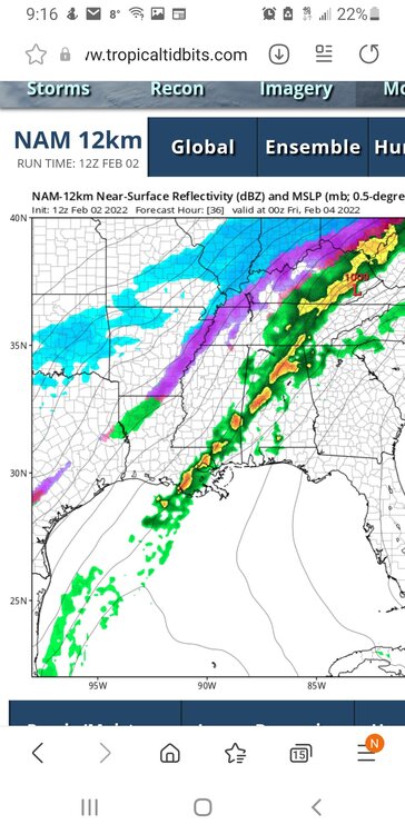
3rd weak wave still on icon. Lol
-
Thats you Dave and vort.
-
 2
2
-
-
1 minute ago, BGM Blizzard said:
Nam 10:1 non-sleet and precip type outputs
.thumb.png.d13743b8823b8a86221658664a1009d1.png)
.thumb.png.657063cea8906db4202f0f220b51006a.png)
Thanks for these maps.
-
1
-
-
Just now, The Iceman said:
Don't worry, he'll run off and start his own upstate NY/Central PA weather board soon enough if things aren't to his liking around here. Pretty funny to see him scurry back to AMWX though after he moved out of the Philly area.
Oh he has a history.
-
1
-
 1
1
-
-
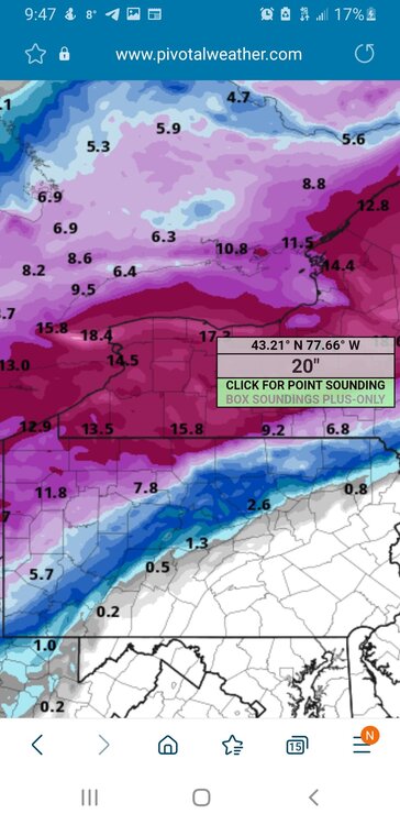
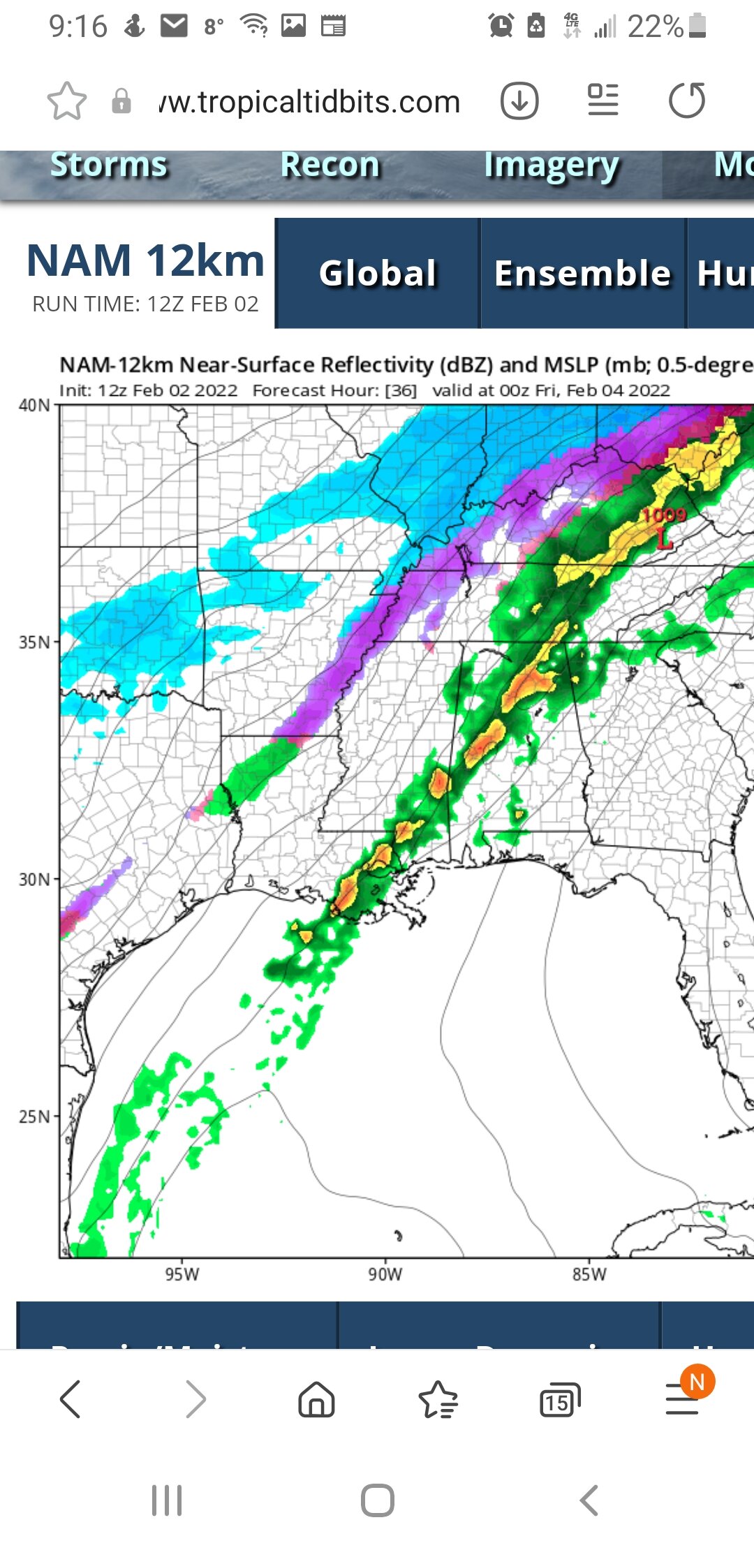
Hi rez gfs goin to drop close to 20 inches on south shore
-
1
-
-
Just now, tombo82685 said:
Noted, Will do. Maybe this isn’t the best community then for me. Sorry for causing such a stir
Tombo we enjoy the input you have. Just dial back the comments.
-
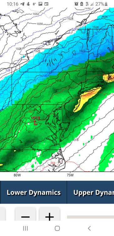
Wave 3 is with piece of energy left behind in Oklahoma i think.
-
First wave was always west need that to pass to get cold in. Sets the stage for 2 and maybe 3
-
Just now, vortmax said:
Not digging 12z NAM as it delays the initial cold air push for the first wave. Seems only NIA get in on frozen overnight.
Forecast was for a inch or less overnight.
-
5 minutes ago, CNY_WX said:
I would say 4:1 is basically sleet. I don’t know know if we ever have snow at 4:1.
Yeah that 4 to 1 is total bs. 6 to 1 yeah I can see for a few hours.
-
1 minute ago, tim123 said:
Can see on hrrr that subtle 3 wave develop in texas.
-
Can see on hrrr that subtle 3 wave develop in texas.
-
3 minutes ago, tombo82685 said:
wise man, srefs are usually to amped up with everything due to the ARW family. I believe nam is involved in them but like yourself don't look at them
Arw does well in these lake enhanced set ups. They may inflate sometimes but gives you the idea.
-
 1
1
-
-
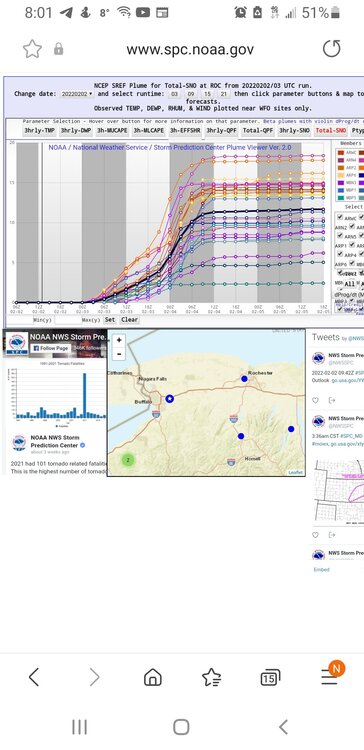
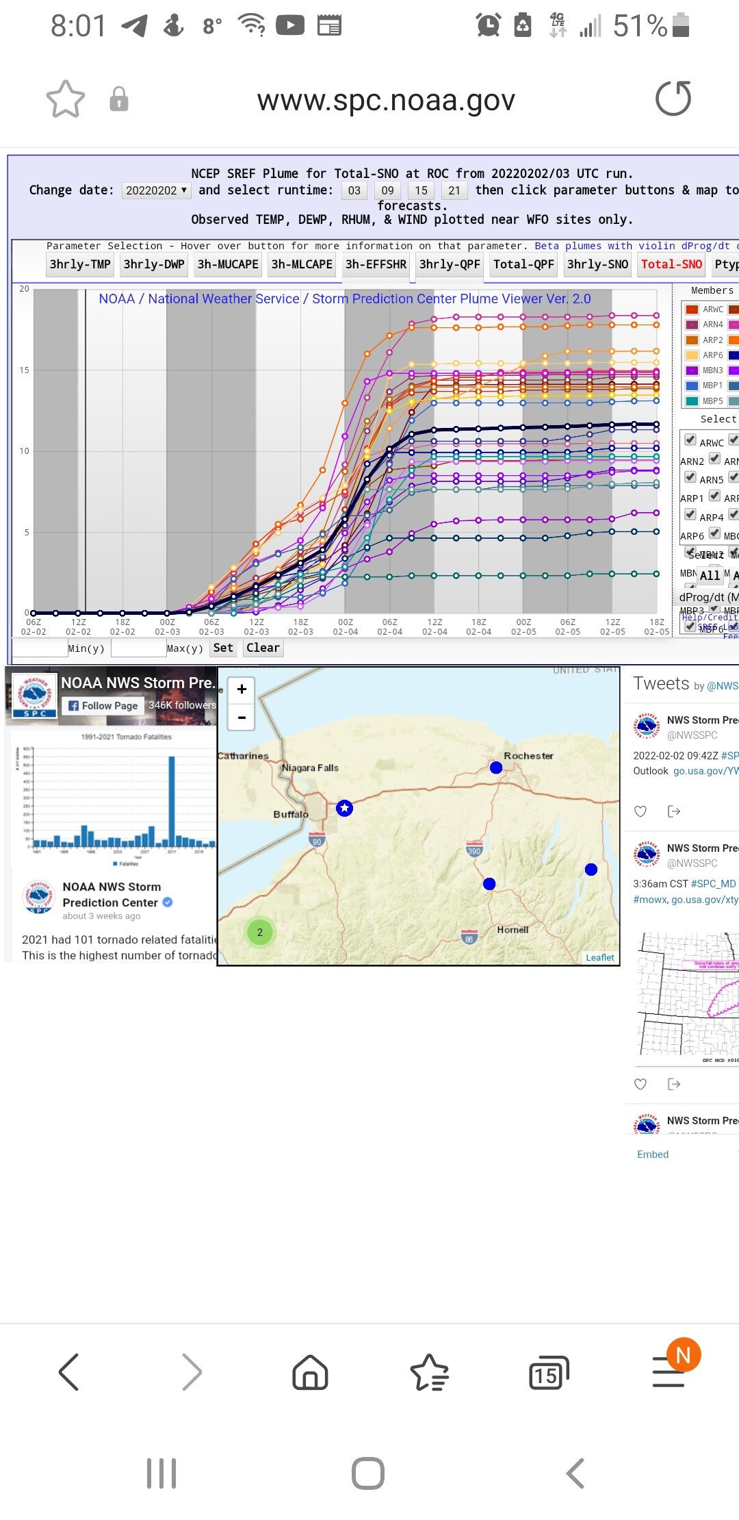
I don't know sref plumes I found tend to do well with lake enhanced storms. They run a whole bunch of diffrent models and runs. But generally I take em with a grain of salt. I believe its a bunch of mesoscale models
-
1
-
-
Bgm do srefs do a standard 10 to 1 on the snow plumes or are ratios factored in?
1 minute ago, BGM Blizzard said:Yeah about 5-10 miles. It's the only mainly snow solution for down here. Not holding my breath given where the rest of the models stand right now.
-
Goin deep pulling out the sref plumes.
-
1
-
2
-
-
3 minutes ago, BGM Blizzard said:
6z Euro
.thumb.png.0e2ac0337d1651858cf09151b191810d.png)
Ticked nw.
-
Its always winter until March 21. Lol
-
Just now, rochesterdave said:
Yep. Enhancement is the wildcard. Could bump Rochester to Buffalo up a few ticks.
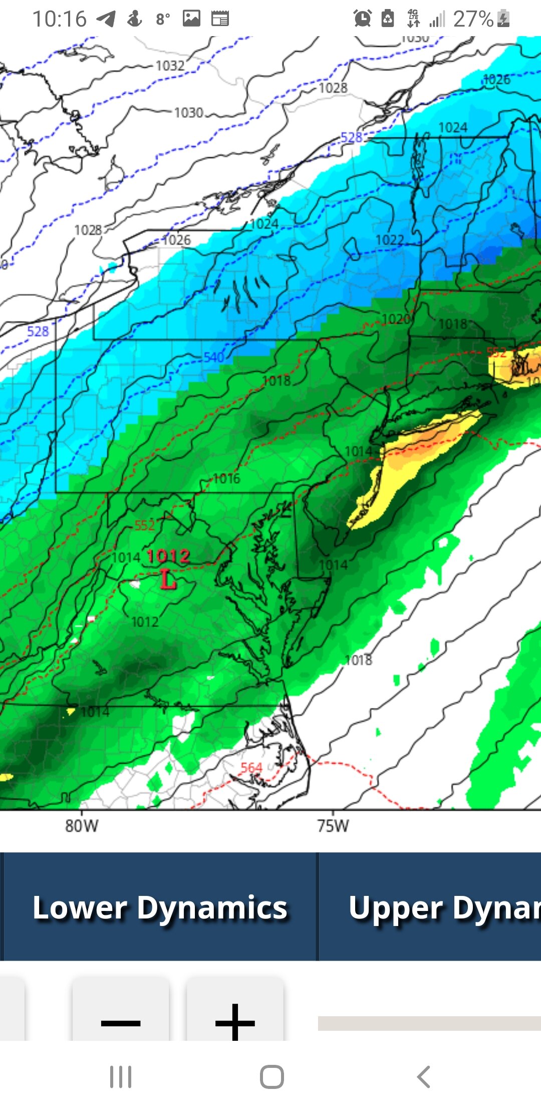
Friday. Based on previous guidance was all set to rush this system
east of the area pretty quickly on Friday. However, trends now
showing up that there could be yet another low-level wave lifting
through to keep snow going through midday while larger scale lift
ramps up again as northern stream trough advances across the Great
Lakes. While this occurs northeast to northerly winds will be
flowing across Lake Ontario with temps at top of inversion
sufficient for lake enhancement. All in all, increased QPF and snow
a bit compared to any larger scale blends and previous forecast. If
the more amplified ECMWF and Canadian-Regional are right on this
trend (supported more now by 06z NAM), then could see even more snow
on Friday especially from lake enhancement. Still cannot rule out
some blowing snow especially in open areas near Lake Ontario. Coord
with near term forecaster on headlines with the system and opted to
go to 15z for end time of warning over far western NY and to 18z for
rest of the area. System finally pulls east late Friday, leaving
persistent but light lake effect off Lake Ontario in a more
northwest flow by that point. Temps chilly on Friday with readings
in the upper teens to near 20F not rising much from overnight lows
Thursday night. Wind chills will be as cold as the single digits
below zero east of Lake Ontario to the single digits above zero
-
3 minutes ago, rochesterdave said:
Not all of us get up at the crack boys. But I knew things were looking up when I saw 50 new posts!!! I knew I liked this one.
Morning Dave. Lake enhancement looks really nice with this one. Some of em have it snowing for 40 hours lol
-
1
-
-
Unusually dead in here this morning.
-
1
-

.png.b62fee1bfa77b7eb8c874a1c0a091e72.png)
.png.fcbfd8938afee73bde4a5847d76dce0a.png)
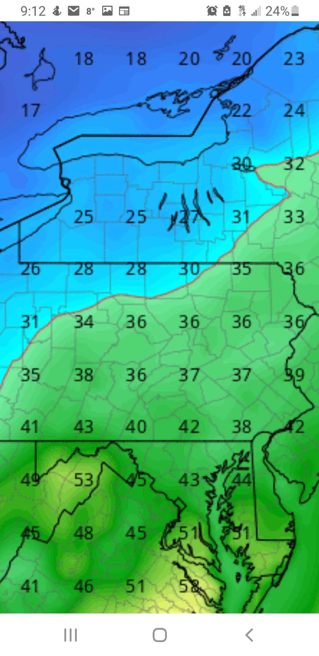

.png.5735212c16f247b19170642b1574c8f7.png)
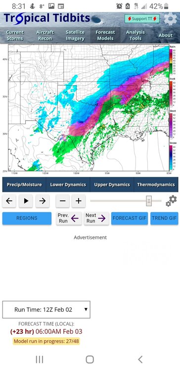
Model Mayhem Snowstorm! 2/2-2/4
in Upstate New York/Pennsylvania
Posted
Definitely has 3rd wave