

tim123
-
Posts
6,682 -
Joined
-
Last visited
Content Type
Profiles
Blogs
Forums
American Weather
Media Demo
Store
Gallery
Posts posted by tim123
-
-
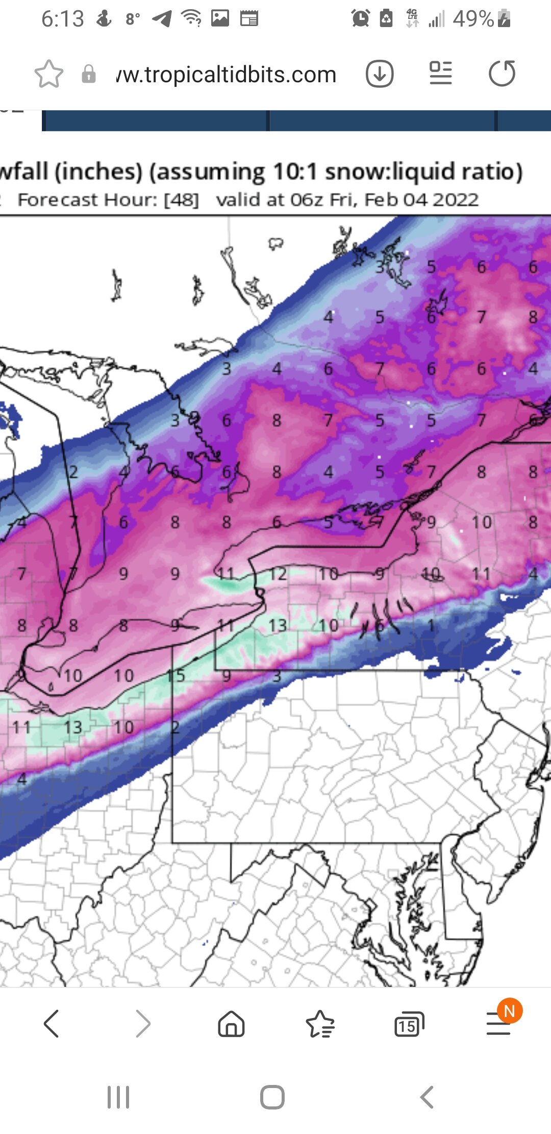
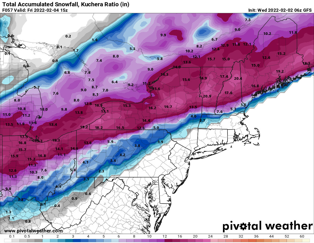
Hi rez canadian to hour 48 at 10 to 1.

-
1 minute ago, tim123 said:
Friday. Based on previous guidance was all set to rush this system
east of the area pretty quickly on Friday. However, trends now
showing up that there could be yet another low-level wave lifting
through to keep snow going through midday while larger scale lift
ramps up again as northern stream trough advances across the Great
Lakes. While this occurs northeast to northerly winds will be
flowing across Lake Ontario with temps at top of inversion
sufficient for lake enhancement. All in all, increased QPF and snow
a bit compared to any larger scale blends and previous forecast. If
the more amplified ECMWF and Canadian-Regional are right on this
trend (supported more now by 06z NAM), then could see even more snow
on Friday especially from lake enhancement. Still cannot rule out
some blowing snow especially in open areas near Lake Ontario. Coord
with near term forecaster on headlines with the system and opted to
go to 15z for end time of warning over far western NY and to 18z for
rest of the area. System finally pulls east late Friday, leaving
persistent but light lake effect off Lake Ontario in a more
northwest flow by that point. Temps chilly on Friday with readings
in the upper teens to near 20F not rising much from overnight lows
Thursday night. Wind chills will be as cold as the single digits
below zero east of Lake Ontario to the single digits above
Buffalo hitting the lake enhancement but not in their snow totals yet until a bit more confident.
-
 1
1
-
-
Friday. Based on previous guidance was all set to rush this system east of the area pretty quickly on Friday. However, trends now showing up that there could be yet another low-level wave lifting through to keep snow going through midday while larger scale lift ramps up again as northern stream trough advances across the Great Lakes. While this occurs northeast to northerly winds will be flowing across Lake Ontario with temps at top of inversion sufficient for lake enhancement. All in all, increased QPF and snow a bit compared to any larger scale blends and previous forecast. If the more amplified ECMWF and Canadian-Regional are right on this trend (supported more now by 06z NAM), then could see even more snow on Friday especially from lake enhancement. Still cannot rule out some blowing snow especially in open areas near Lake Ontario. Coord with near term forecaster on headlines with the system and opted to go to 15z for end time of warning over far western NY and to 18z for rest of the area. System finally pulls east late Friday, leaving persistent but light lake effect off Lake Ontario in a more northwest flow by that point. Temps chilly on Friday with readings in the upper teens to near 20F not rising much from overnight lows Thursday night. Wind chills will be as cold as the single digits below zero east of Lake Ontario to the single digits above zero -
Any power outages down that way and could be a real disaster.

-
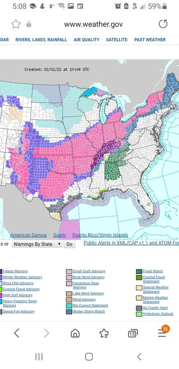
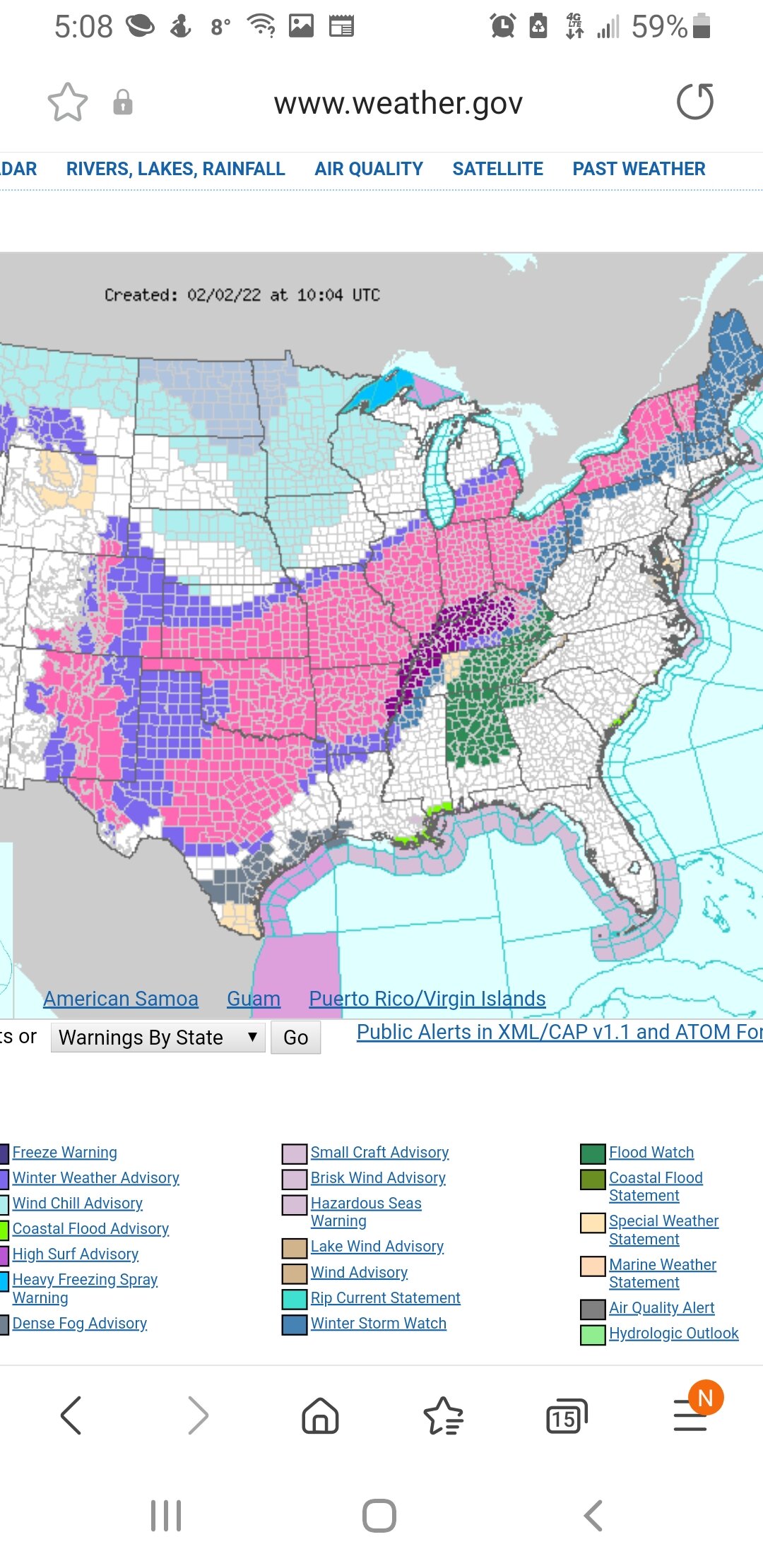
Big ice storm over a huge area in Ohio and Mississippi Valley areas.
-
2 minutes ago, 96blizz said:
Thanks man - means a lot.
It’s been a long road. Many of you guys may remember what I was going through last February. Y’all were so helpful and understanding. My Mom had her heart attack on February 4th and fought hard for a couple of weeks. She’d be so, so proud of what I’ve done since if she were still here.And no f*cking doubt she’d be dropping Kuchera maps too. She was Uber positive!
Absolutely shed be proud. She is proud looking down on ya.
-
 1
1
-
-
2 minutes ago, TugHillMatt said:
He has been a bit grumpier this week. That's the "Philly edginess" coming out on lack of sleep due to overnight model check-ins.
The guy thinks I am a idiot for saying 12 to 13 to one ratios when its clear as day. 10 to 1 is like the only ratio he knows cause he is from Philadelphia. Lol
-
1 minute ago, 96blizz said:
Good for you bro. I’ve always read you as a great dude. Maybe a little disgruntled at times - but a guy that would go the lengths for people he cares about.
The back and forth is fun as shit - and totally harmless. I always say this about my best friends from middle school, “If we aren’t busting your balls, you can assume we don’t like you anymore.”
Congrats on your personal achievements for you and the family.
-
4
-
-
Just now, 96blizz said:
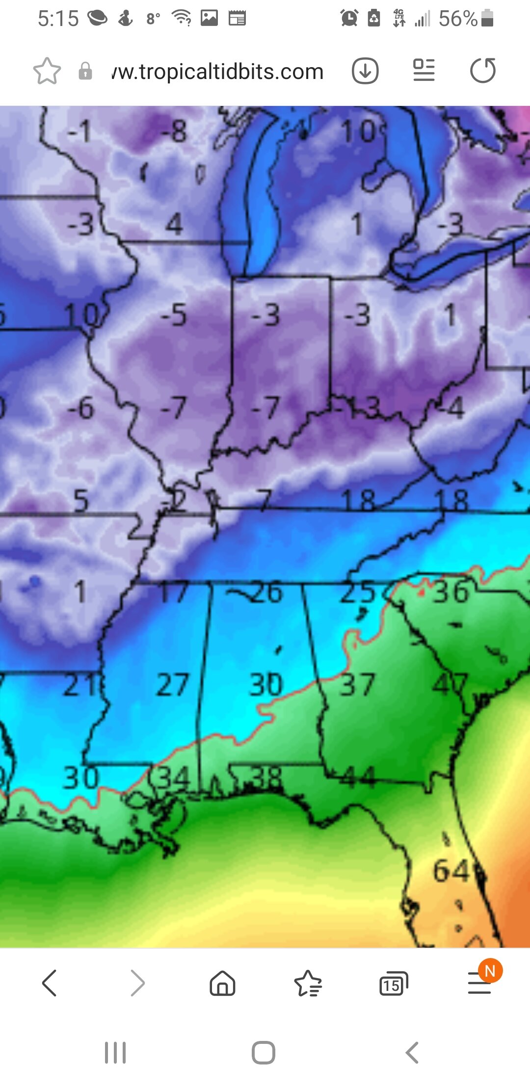
6z GFS. Boner.

And this doesn't really factor in any enhancement. Or atleast a accurate representation.
-
6 minutes ago, TugHillMatt said:
What are you talking about? The only weather talk I ever get annoyed with coming from others is Buffwx and Max talking about swimming pool-worthy thaws in the dead of winter. Ain't nobody got time for that.
Not pointing any one out but that dam stupid snowman avatar really is a pisser.
-
 1
1
-
-
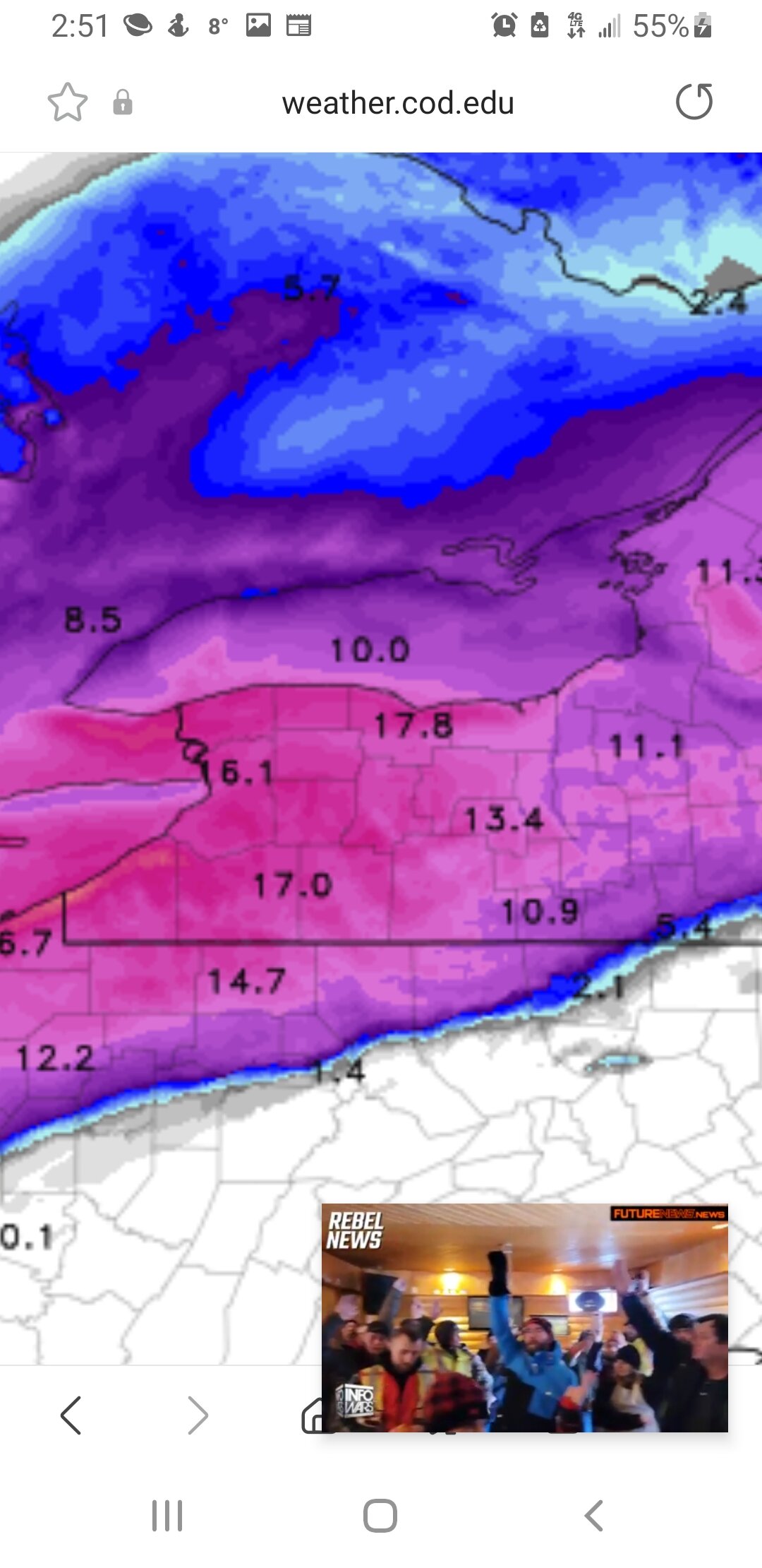
96 blizzard woke up to get himself a kuchie map and he thought somebody was barbecuing. He said oh lord Jesus its 10 to 1. Ain't nobody got time for that.
-
1
-
-
1 minute ago, 96blizz said:1 minute ago, 96blizz said:
Jerks.
Dude its a weather forum and they get annoyed when you talk weather. Smh. Baffles me too.
-
 2
2
-
-
Fwiw icon came nw some more.
-
Can almost bet meso models will have close to 2 feet totals areas south of ontario.
-
No one is talking about it but someone in se ny is looking at big ice. Catskills area?
-
Buffalo issued warnings as well. 8 to 12. Definitely feel areas from sodus to Hamilton ontario will have 12 to 16.
-
1
-
-
Also of note models now seem to wanna extend steady snow thru Friday morning and in lake enhanced areas all day Friday into Friday eve
-
Pretty neat as you go toward ny pa border up to Central ny the map with ratios shows much lower totals do too 6 to 8 to 1 ratios. Up north of 5 and 20 looks like 12 13 to 1
-
Hrrr goin balls out. Still snowing.

-
 3
3
-
-
19 minutes ago, BGM Blizzard said:
Pivotal has maps anyway, looks similar to 18z but maybe not as dry on the northern side at first glance.

Hey bmg. You got high rez canadian?
-
Just now, tim123 said:
Output looks almost same. Oddly enough its the farthest south model now. Lol.
Playing catchup? I mean all the models have been south north south north for 2 days now. Hard to figure out where axis goes.
-
1
-
-
Output looks almost same. Oddly enough its the farthest south model now. Lol.
-
1
-
-
2 minutes ago, Rd9108 said:
figured I was the only crazy bastard still awake. Looks about as good as I think this can.
Its on its own.
-
18 minutes ago, tombo82685 said:
nope, the 15dbz echo over monroe co
I have no problem believing that avatar is really what you look like.
-
2
-

Model Mayhem Snowstorm! 2/2-2/4
in Upstate New York/Pennsylvania
Posted
If nam is correct its goin to snow into sat morning.