BoulderWX
-
Posts
1,260 -
Joined
-
Last visited
Content Type
Profiles
Blogs
Forums
American Weather
Media Demo
Store
Gallery
Everything posted by BoulderWX
-
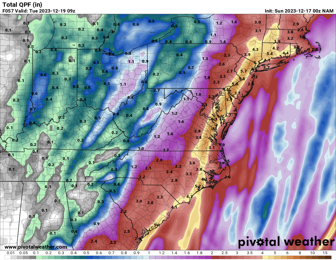
Two Mdt to high impact events NYC subforum; wknd Jan 6-7 Incl OBS, and mid week Jan 9-10 (incl OBS). Total water equiv by 00z/11 general 2", possibly 6" includes snow-ice mainly interior. RVR flood potential increases Jan 10 and beyond. Damaging wind.
BoulderWX replied to wdrag's topic in New York City Metro
Storm on the table. No worrying about semantics now. Will check back wednesday or Thursday- 3,610 replies
-
- 1
-

-
- snow
- heavy rain
- (and 5 more)
-
Two Mdt to high impact events NYC subforum; wknd Jan 6-7 Incl OBS, and mid week Jan 9-10 (incl OBS). Total water equiv by 00z/11 general 2", possibly 6" includes snow-ice mainly interior. RVR flood potential increases Jan 10 and beyond. Damaging wind.
BoulderWX replied to wdrag's topic in New York City Metro
I’d take that in a second. Road trip weekend. -
Two Mdt to high impact events NYC subforum; wknd Jan 6-7 Incl OBS, and mid week Jan 9-10 (incl OBS). Total water equiv by 00z/11 general 2", possibly 6" includes snow-ice mainly interior. RVR flood potential increases Jan 10 and beyond. Damaging wind.
BoulderWX replied to wdrag's topic in New York City Metro
Take a model run series off and come back to exactly your prediction. Supression depression. I know we’re a week off but overwhelming guidance shows a souther slidern. Some seas will see flakes but this is definitely not a snow storms lol for NY metro -
GFS remains relatively consistent at 00z and 06z. Consistency doesn’t mean accuracy but nice to see a storm several runs in a row.
-
Two Mdt to high impact events NYC subforum; wknd Jan 6-7 Incl OBS, and mid week Jan 9-10 (incl OBS). Total water equiv by 00z/11 general 2", possibly 6" includes snow-ice mainly interior. RVR flood potential increases Jan 10 and beyond. Damaging wind.
BoulderWX replied to wdrag's topic in New York City Metro
Some decent runs today from the GFS. Honestly would have taken any of them, but this one would make up for a lot a of disappointment the past two years. still putting chances of over 3” snowfall at 15% this far out but I’ll take the potential as something to track -
Ahhh if only…
-
Never said there won’t be storms to track, if you’re going to talk about me not knowing what I’m talking about and talking in absolutes it would probably be best if you were accurate in your depiction of what I posted. Literally said I was glad he was finally accepting that there won’t be a major pattern change the first half of this month and that in order to get a cold storm along 95, everything would have to line up exactly right and there is nothing to support that scenario. That’s all.
-
Welcome back to reality! First step is acceptance and good to see you’ve checked that box!
-
Nothing at all to worry about. Looking at about .50 - 1.00”
-
If you want any real chances of a snowstorm before February all bets point to the Rockies. Anything on the east coast including NE will be a thread the needle through timing situation. I think we have a few chances in February but I will go on record as saying I don’t see enough of a pattern shift to produce any meaningful snow along the east coast, particularly the 95 corridor until the last week of January into February. would love to be wrong and wilL admit if I am, but not seeing anything that gets me excited about a colD and snowy January
-
Moderate-High Impact Storm Noon Sun Dec 17, 2023 - 4PM Mon Dec 18. Flooding rain I95 corridor northwestward, coastal tidal flooding, brief periods of damaging 50 MPH+ wind gusts LI/CT Monday, ends as a little wet snow interior elevations Tue morning.
BoulderWX replied to wdrag's topic in New York City Metro
Up to 4.25” as back edge pulls through with heavy downpours. Only one gust of wind recorded, topping out around 15mph -
Moderate-High Impact Storm Noon Sun Dec 17, 2023 - 4PM Mon Dec 18. Flooding rain I95 corridor northwestward, coastal tidal flooding, brief periods of damaging 50 MPH+ wind gusts LI/CT Monday, ends as a little wet snow interior elevations Tue morning.
BoulderWX replied to wdrag's topic in New York City Metro
Just topped 4” for the event. Luckily winds haven’t been bad IMBY or we’d be having some major issues -
Moderate-High Impact Storm Noon Sun Dec 17, 2023 - 4PM Mon Dec 18. Flooding rain I95 corridor northwestward, coastal tidal flooding, brief periods of damaging 50 MPH+ wind gusts LI/CT Monday, ends as a little wet snow interior elevations Tue morning.
BoulderWX replied to wdrag's topic in New York City Metro
Up to 2.75” of rain but little to no wind. Not even breezy. -
Moderate-High Impact Storm Noon Sun Dec 17, 2023 - 4PM Mon Dec 18. Flooding rain I95 corridor northwestward, coastal tidal flooding, brief periods of damaging 50 MPH+ wind gusts LI/CT Monday, ends as a little wet snow interior elevations Tue morning.
BoulderWX replied to wdrag's topic in New York City Metro
What areas? -
Moderate-High Impact Storm Noon Sun Dec 17, 2023 - 4PM Mon Dec 18. Flooding rain I95 corridor northwestward, coastal tidal flooding, brief periods of damaging 50 MPH+ wind gusts LI/CT Monday, ends as a little wet snow interior elevations Tue morning.
BoulderWX replied to wdrag's topic in New York City Metro
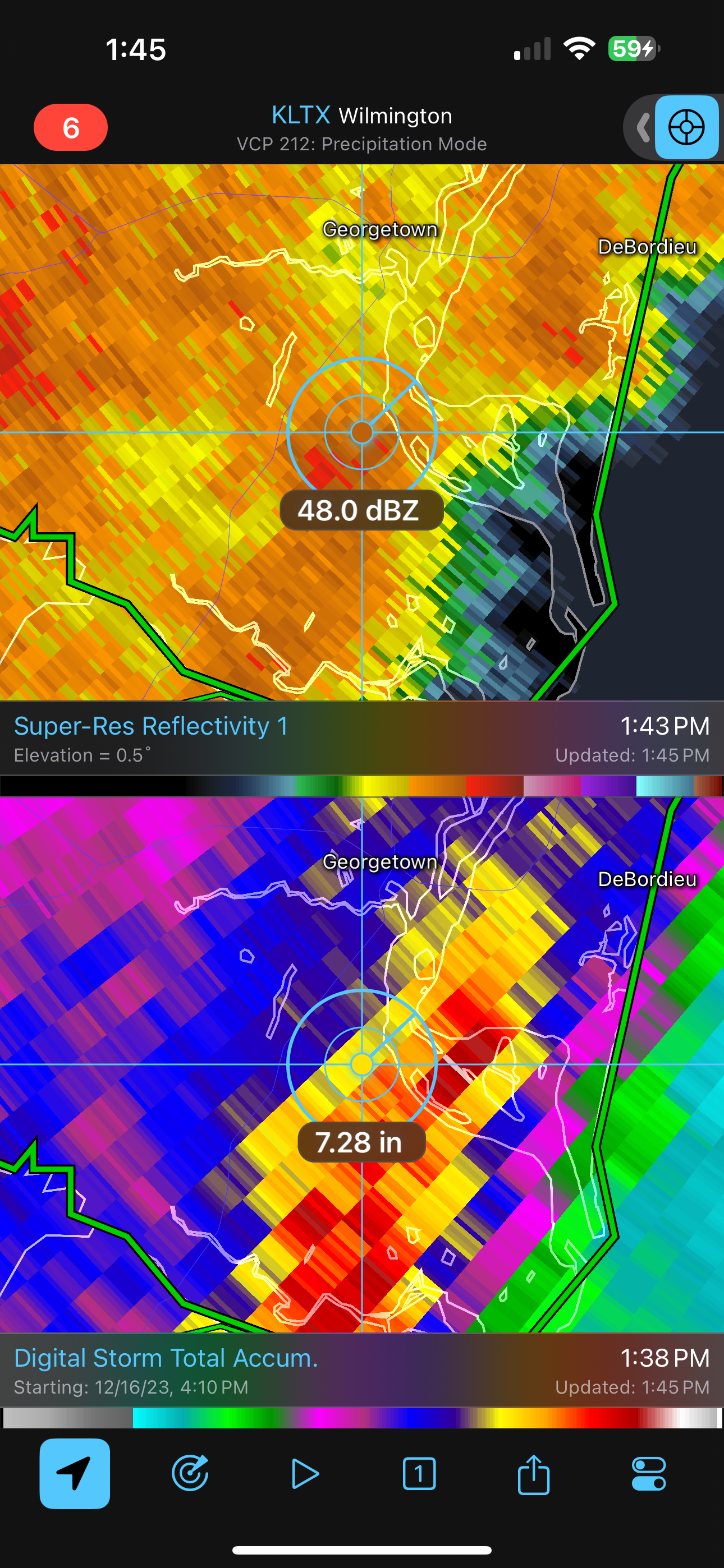
Lowest I saw was 992 of SC coast. NAM still going with 5” imby. Should be an interesting night. -
Moderate-High Impact Storm Noon Sun Dec 17, 2023 - 4PM Mon Dec 18. Flooding rain I95 corridor northwestward, coastal tidal flooding, brief periods of damaging 50 MPH+ wind gusts LI/CT Monday, ends as a little wet snow interior elevations Tue morning.
BoulderWX replied to wdrag's topic in New York City Metro
Fair to say the 12”+ prediction from a few hours ago will come to fruition.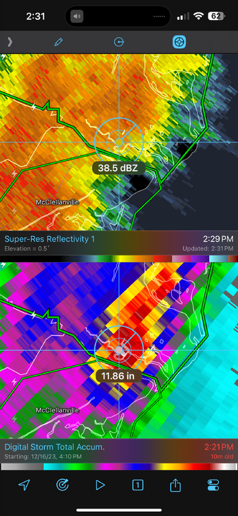
- 489 replies
-
- 1
-
-
- flooding rains
- coastal flooding
- (and 4 more)
-
Moderate-High Impact Storm Noon Sun Dec 17, 2023 - 4PM Mon Dec 18. Flooding rain I95 corridor northwestward, coastal tidal flooding, brief periods of damaging 50 MPH+ wind gusts LI/CT Monday, ends as a little wet snow interior elevations Tue morning.
BoulderWX replied to wdrag's topic in New York City Metro
Always looking downstream with events like these
- 489 replies
-
- 1
-
-
- flooding rains
- coastal flooding
- (and 4 more)
-
Moderate-High Impact Storm Noon Sun Dec 17, 2023 - 4PM Mon Dec 18. Flooding rain I95 corridor northwestward, coastal tidal flooding, brief periods of damaging 50 MPH+ wind gusts LI/CT Monday, ends as a little wet snow interior elevations Tue morning.
BoulderWX replied to wdrag's topic in New York City Metro
To be clear I meant somewhere along the east coast as a whole. I do think someone in the mount Holly and upton area could see 6+- 489 replies
-
- 1
-
-
- flooding rains
- coastal flooding
- (and 4 more)
-
Moderate-High Impact Storm Noon Sun Dec 17, 2023 - 4PM Mon Dec 18. Flooding rain I95 corridor northwestward, coastal tidal flooding, brief periods of damaging 50 MPH+ wind gusts LI/CT Monday, ends as a little wet snow interior elevations Tue morning.
BoulderWX replied to wdrag's topic in New York City Metro
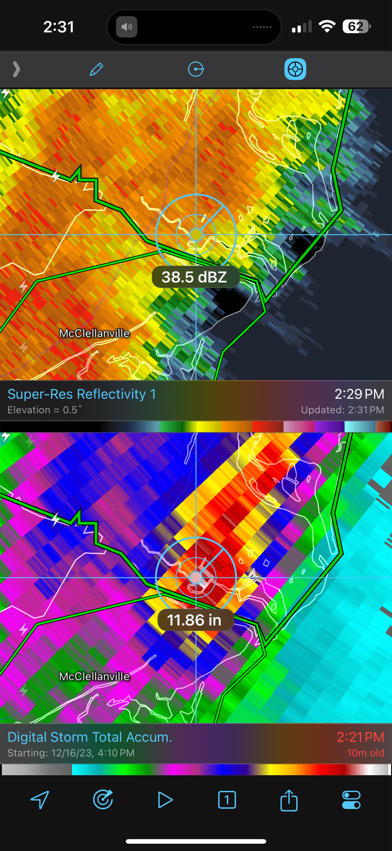
Already seeing 4-5” areas in SC under training 40/50 Dbz Bands. Wouldn’t be surprised if someone sees a foot from this storm- 489 replies
-
- 2
-
-
- flooding rains
- coastal flooding
- (and 4 more)
-
Anyone have a favorite radar showing larger picture?
-
Moderate-High Impact Storm Noon Sun Dec 17, 2023 - 4PM Mon Dec 18. Flooding rain I95 corridor northwestward, coastal tidal flooding, brief periods of damaging 50 MPH+ wind gusts LI/CT Monday, ends as a little wet snow interior elevations Tue morning.
BoulderWX replied to wdrag's topic in New York City Metro
First time I can ever remember modeling being so consistent for 3-5” of rain imby. Hoping no winds over 35 for the power outage element. -
Moderate-High Impact Storm Noon Sun Dec 17, 2023 - 4PM Mon Dec 18. Flooding rain I95 corridor northwestward, coastal tidal flooding, brief periods of damaging 50 MPH+ wind gusts LI/CT Monday, ends as a little wet snow interior elevations Tue morning.
BoulderWX replied to wdrag's topic in New York City Metro
All things pointing to 2-4” here in central and northern nj. Winds could gust past 40. Should be a nice little storm. Wish it was white and not wet but provides something interesting to track on a Sunday afternoon and should make some of the games more fun to watch- 489 replies
-
- 2
-
-
- flooding rains
- coastal flooding
- (and 4 more)
-
Moderate-High Impact Storm Noon Sun Dec 17, 2023 - 4PM Mon Dec 18. Flooding rain I95 corridor northwestward, coastal tidal flooding, brief periods of damaging 50 MPH+ wind gusts LI/CT Monday, ends as a little wet snow interior elevations Tue morning.
BoulderWX replied to wdrag's topic in New York City Metro
4-6 verbatim between the two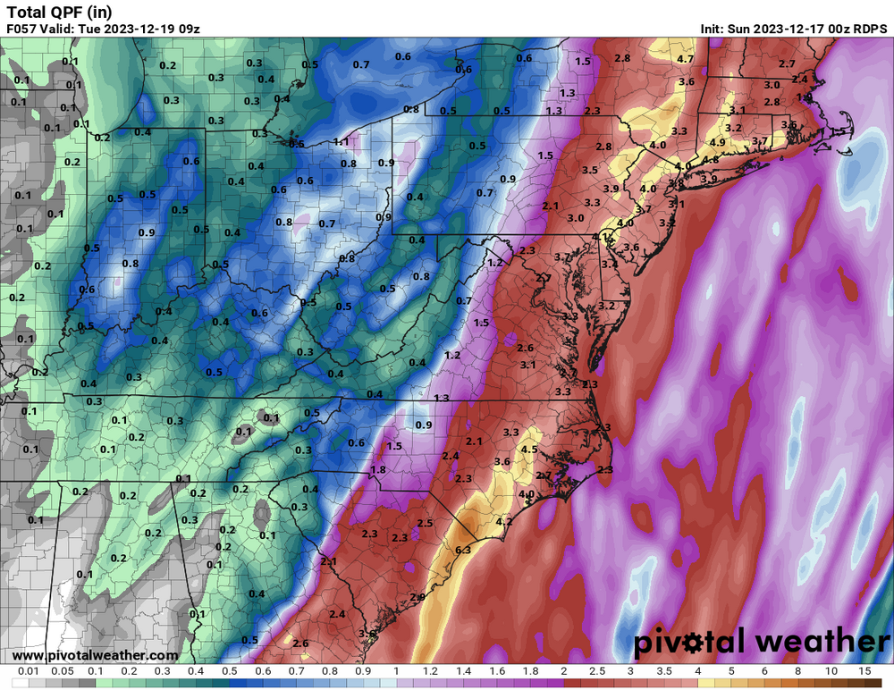

- 489 replies
-
- 1
-
-
- flooding rains
- coastal flooding
- (and 4 more)
-
Moderate-High Impact Storm Noon Sun Dec 17, 2023 - 4PM Mon Dec 18. Flooding rain I95 corridor northwestward, coastal tidal flooding, brief periods of damaging 50 MPH+ wind gusts LI/CT Monday, ends as a little wet snow interior elevations Tue morning.
BoulderWX replied to wdrag's topic in New York City Metro
Ok not too terrible. Appreciate the quick response! -
Moderate-High Impact Storm Noon Sun Dec 17, 2023 - 4PM Mon Dec 18. Flooding rain I95 corridor northwestward, coastal tidal flooding, brief periods of damaging 50 MPH+ wind gusts LI/CT Monday, ends as a little wet snow interior elevations Tue morning.
BoulderWX replied to wdrag's topic in New York City Metro
Horrible with interpreting wind maps and hate to be the IMBY guy. But what would north central NJ be looking at for winds with this roughly. I live in morris county so not too close to the coast but only about 30 miles west of NYC- 489 replies
-
- 1
-
-
- flooding rains
- coastal flooding
- (and 4 more)