

poolz1
-
Posts
2,764 -
Joined
-
Last visited
Content Type
Profiles
Blogs
Forums
American Weather
Media Demo
Store
Gallery
Posts posted by poolz1
-
-
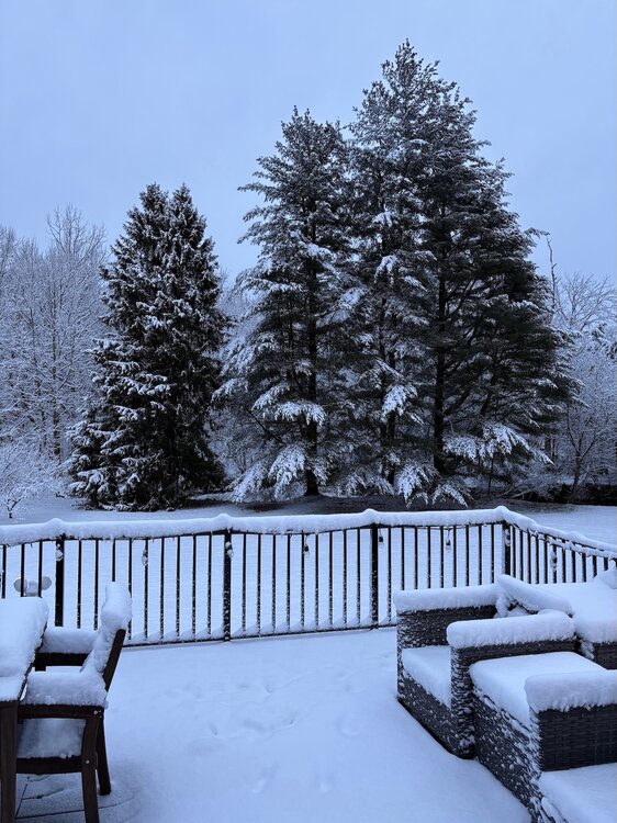
29/27. 5" otg with some light snow falling.
-
 5
5
-
-
31/29 mod snow even under lighter returns. Measured 4" at 1045.
-
mod snow. just measured 1.5" on the board. Driveway and roads covered. 32.8/31
-
5
-
-
5 minutes ago, Chris78 said:
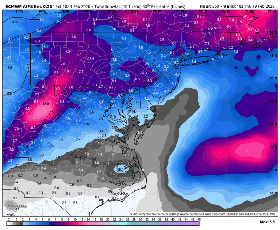
He'll yes. Most of the 12z models want to get us good with the IVT
Our best shot at this thing. I hope we are puking dendrites for several hours tomorrow night.
-
1
-
-
Traffic cams show light snow falling just west of HGR.
-
3
-
-
Already some snow showers moving into the western areas. Temp at the house is 16 and cloudy. Should be no problem with road stickage
-
2
-
-
16 minutes ago, Mrs.J said:
So something happened this week that I need to put in writing I am so mad.
So the oldest Ms. J is in her last semester. And is looking everyday and applying for jobs in this shitty market. Fast forward this week, Monday to be exact. She finally gets an interview for an internship. But on the same day she got contacted for another job that would be exactly what she would like to have. Local DC communications company, would be remote and good benefits and pay. With all the jobs she has replied to lately she did not remember applying to this one. An interview is set up over Microsoft Teams. It is one of those interviews where you are sent questions and then you have to record yourself with a 1 minute answer. Weird but I have seen interviews like these used to narrow down candidates. She is told that she would hear something back the following day. She gets contacted again through Microsoft Teams and asked if she is available to talk over the phone at a certain time on Tuesday. Let me just say here that Mr. J was already kind of surprised that someone who would be fresh out of school would even be considered for this job but we are all kind of caught up in the excitement. Anyways she lets us know she is offered the job and with an after graduation start date. Perfect right?? Well that is where the red flags started to pop up. She had class into the night and then one of her club meetings after so we had not had the time to talk with her. She asked should she cancel the interview for the internship and Mr. J said until you have a signed contract no. So we asked her about the contract. 2 pages, only 2 pages and what was on those 2 pages made the Spidy sense of Mr. J go off. He started digging. Mind you Ms. J had already checked into the name of the person who originally sent the first contact. He was an employee. But the person who called her was someone calling from an AZ phone number and had a thick accent. And his email to send the “contract” to ended not with a .com. In said “contract” it listed the job posting again and all the benefits, which mind you was what was exactly on the companies website. The second page was asking for proof of rent, ID, SS, passport and bank info for “direct deposit” At the bottom was a line for the start date and it was left blank even though she had given a start date. She was to fill out the paperwork and send it back by the end of business on Wednesday. We told her to send us what she had gotten and started to try to connect the dots. Told her to hold off sending anything until we dug a bit more. As a victim of ID theft back in the day I started to get that sick feeling in my gut. She was contacted one more time Tuesday evening saying that she can send the info that night. She did not even have anything printed out and replied she would the next day. Between that and the digging that Mr. J was doing we told her to not send anything at all. That is was looking more and more like a phishing scheme that we had never seen before. What set off his concern was the salary that was being given to someone with her qualifications. Mr. J immediately found an email to the company that was being spoofed asking if in fact she had been given a job offer. We have yet to hear back from them but were 100% sure that she should not send off any sensitive information.
You guys… this world sucks! This kid has been busting her ass to not only finish college but has been stressing over not being a burden on us. Which she will never be and was told as such. She is working 2 jobs and making contacts. And wants a job she wants to be self sufficient. I feel absolutely gutted for her. She still has her interview for the internship but after what just happened she went back in to check if she even applied for this. And cross reference the contact with the actual company. This one checks out and will actually be a face to face interview. She will now be keeping a spread sheet of what she applies for on top of the email trail. We are glad that she still feels close enough to us to keep us in the loop. Because had she not this could have ended very badly. Sorry for this being so long but I needed to put my thoughts out in words with people not connected directly.
Everyone enjoy this sunny day.
Thank you for posting this. I am sorry your daughter went through this BS. I have a daughter who is in her second year at UMD, working her butt off. I will be relaying this information to her and my wife. Never knew of or even imagined this method of scamming!
-
1
-
-
7 minutes ago, psuhoffman said:
The median increased also!
yea, but the real question is what is your 3 model average?
-
 2
2
-
-
Euro has the front runner that knocks down heights. H5 looks like a decent passage south of us shortly after. Don't know what the surface looks like but a slight moral booster on today's runs.
-
Perfect radiational cooling conditions right now especially in low lying areas. Currently 8 degrees
-
1
-
-
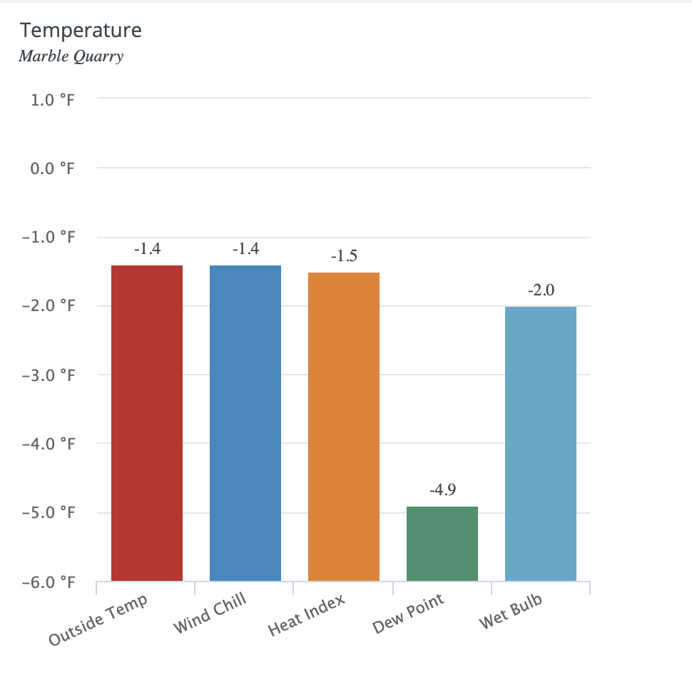
Still below 0 at 9am. Impressive.

-
37 minutes ago, MN Transplant said:
The temperature differences across the regions are getting wilder as we get later into the week.
Airports: DCA 13, IAD 6, BWI 8. Mine was 9.1 and most of northern VA looks to be in the 6-12 range. But MD is...cold.
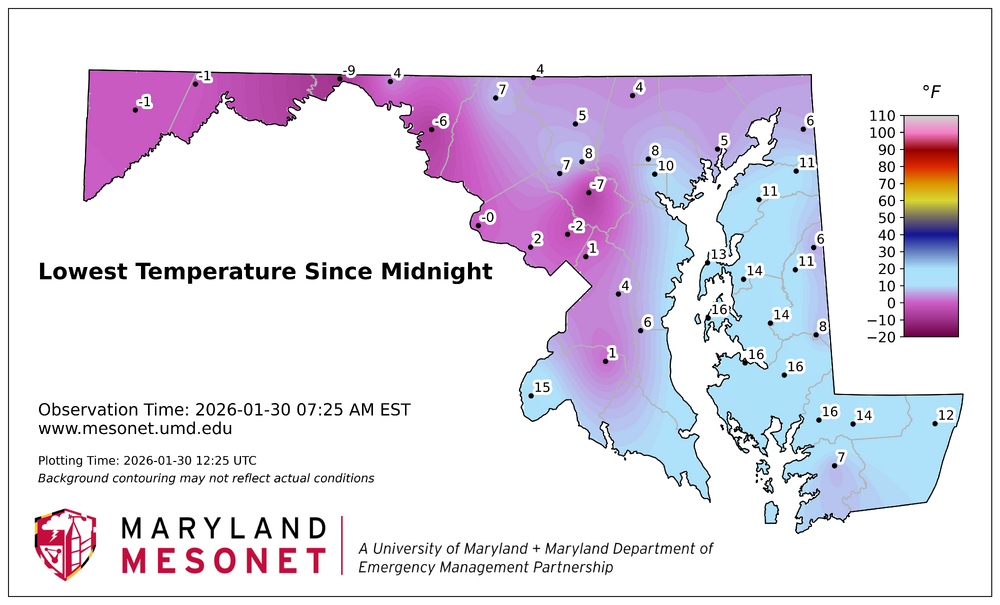
I am about 2 miles SE of the -6 reading in Wash Co. Can confirm a -6 reading at the house this morning before leaving for work. .7 degrees shy of the record low imby of -6.7 in February 2014.
-
2
-
-
Temp has really fallen right before sunrise. 7 when I got up this morning at 530 and has fallen to 3 currently. Nose hair freezing cold!
-
1
-
-
13 hours ago, Chris78 said:
What did you all end up with?
I had just under 7" prior to the switch over and atleast 1.5" of sleet. Maybe a little more
Thinking I'm going with 8.5
Very similar. Just difficult to measure. Had around 6" snow and 2"-2.25" sleet. I was going to go with 8" total. Some of the worst stuff to shovel.
-
Didn't separate sleet from snow qpf just due to so much mixing. 1.58" total. 7" otg.
-
Temp back down to 13 after a high of 16. Mod sleet currently.
-
Just hit 2" of sleet for the day. 6.5" otg 7.5" total frozen and temp is falling. Lost 2 degrees in the past hour or so.
-
Just measured 1.25" sleet/pixie dust since the transition took place. Around 7" total frozen for the day. 16 with steady sleet.
-
Lighter returns were a mix but back to heavy snow with better rates. 5.5" 12/9
-
2
-
-
2 minutes ago, WVclimo said:
Might take a bit longer this morning. Facebookers saying WV I-81 is a mess and "hasn't been touched." I'll have a hot pot going all day though.

Radar is really blossoming heavier returns to the SW of this area. Should really start to crank here soon.
-
3
-
-
Measured just shy of 3". 12/8
-
1
-
-
It's perfect outside but brutal. Mod snow 13/7 Maybe a half inch so far but starting to really come down now.
-
Currently 1039.6mb and continuing to creep up. Pretty rare with a storm approaching especially with a high the is entrenched and not flying off the coast of Maine.
-
1
-
-
Every 7 days. That block is relentless. Sure, an op out at range but it actually is a plausible scenario based on its own LR ens. I would weenie my own post if I could.

-
2
-
 5
5
-


June Discobs 2026
in Mid Atlantic
Posted
mmmmm Lucky Corner!
Peak gust 39mph .22"
Nice for the garden.