

WxWatcher007
-
Posts
35,872 -
Joined
-
Last visited
Content Type
Profiles
Blogs
Forums
American Weather
Media Demo
Store
Gallery
Everything posted by WxWatcher007
-
Any time you have a front draped like that during this boring time of year it’s worth a little attention, but the signal is weak at best right now. We’re about 3-4 weeks away from the pattern becoming much more favorable for TC genesis if the guidance is to be believed. The homebrew regions are warm, a niña seems a lock for the peak of the season, and the WAM is active which should mean plenty of good waves during CV season.
-
This—a pretty rare phenomenon in itself but it’s basically unheard of for a system to jump basins and then become a major hurricane.
-
Massive and razor sharp chunks of ice leveling structures and smiting nonbelievers?
-

2022 Atlantic Hurricane Season Tracking Thread
WxWatcher007 replied to WxWatcher007's topic in Mid Atlantic
Yeah unless things pop along a front, I think we’re quiet for a few weeks. Get your sleep now. -
2022 Atlantic Hurricane season
WxWatcher007 replied to StormchaserChuck!'s topic in Tropical Headquarters
Good stuff. Setting aside activity, on balance the biggest CONUS event was Ida by a mile, which doesn’t really denote a memorable season in terms of lasting impact outside of the devastation in Louisiana and NJ/NY. The best way to look at it is this: Nobody talks about the 1992 Atlantic hurricane season—a below average season itself—they talk about the storm, Andrew. The same holds true for 1999, which was very active in terms of major hurricanes, and while one of those made landfall in the CONUS, it’s the category two hurricane, Floyd, that’s memorable in terms of impact. Those storms were the season. Surely severe in impact, but not reflective of the season on balance. On the opposite end, people know of years where there are multiple severe to catastrophic events across a region or multiple regions. 1954 (Carol, Hazel, Edna) 2004 (Charley, Frances, Ivan, Jeanne) 2005 (Too many to name) 2017 (Harvey, Irma, Maria, Nate—for Central America) 2020 (another obvious one IMO) Here, the seasons themselves are known. They are known not necessarily for an individual storm, but the number and ferocity of impacts. We’ll see what happens this season. Agree with 40/70 on New England. A lot of impacts which is statistically anomalous for sure, but outside of Ida in parts of CT and historic river flooding in some locations, nothing truly memorable. The October system was a beast though. That was my best chase all season. That was basically a category one hurricane impact for much of coastal Mass and the damage, while localized, was substantial. -
I found this to be absolutely hilarious.
-
For posterity. Hurricane Bonnie Discussion Number 32 NWS National Hurricane Center Miami FL EP042022 1000 AM CDT Tue Jul 05 2022 Earlier microwave images reveal a well-developed inner core structure with a 10-nm-wide eye, and impressive curved band features in the west and south parts of the cyclone. The surrounding cloud tops have cooled quite a bit during the past few hours, but the eye temperature hasn't warmed that much. The initial intensity is increased to 100 kt for this advisory and is supported by a blend of the Dvorak satellite intensity estimates from TAFB and SAB. It appears as though modest northeasterly shear has begun to restrict the outflow some in the north portion of the cyclone, and this shear is expected to persist during the next 24 hours. Consequently, some fluctuations in strength are possible during the period and the NHC forecast shows a slight increase in intensity in 12 hours in deference to the recent inner core improvement. Afterward, the inhibiting shear should decrease, however,the GFS and ECMWF SHIPS intensity models show the cyclone traversing cooler oceanic surface temperatures and moving into a less favorable thermodynamic surrounding environment. A combination of these negative intensity contributions should cause Bonnie to slowly weaken through the remainder of the period and the official forecast follows suit. Bonnie's initial motion is estimated to be westward, or 280/12 kt. A mid-tropospheric ridge anchored to the north of the cyclone should keep it on a west to west-northwest heading through the entire forecast period. Around mid-period, however, a weakness in the ridge is forecast to develop over the Baja California peninsula, which should temporarily slow Bonnie's forward speed. The track forecast is a little faster than the previous one beyond day 3 and is based on the TVCE multi-model consensus aid. Although the core of Bonnie is expected to remain well south of Mexico, rough surf and the potential for rip currents will continue to affect southwestern Mexico for another day or two. FORECAST POSITIONS AND MAX WINDS INIT 05/1500Z 15.3N 104.3W 100 KT 115 MPH 12H 06/0000Z 15.6N 106.2W 105 KT 120 MPH 24H 06/1200Z 16.0N 108.3W 95 KT 110 MPH 36H 07/0000Z 16.3N 110.4W 90 KT 105 MPH 48H 07/1200Z 16.8N 112.7W 85 KT 100 MPH 60H 08/0000Z 17.4N 115.3W 80 KT 90 MPH 72H 08/1200Z 18.2N 118.4W 75 KT 85 MPH 96H 09/1200Z 19.5N 125.1W 60 KT 70 MPH 120H 10/1200Z 20.4N 131.3W 45 KT 50 MPH $$ Forecaster Roberts
-
It’s my birthday! Now shower me with praise and wishes of successfully chasing a strong category two hurricane with a tractor tire eye!
-
This is my first dreary birthday in recent memory, though last year I was on my way to Florida to chase Elsa.
-
Definitely maximizing its potential out in the EPAC.
-
2022 Atlantic Hurricane Season Tracking Thread
WxWatcher007 replied to WxWatcher007's topic in Mid Atlantic
-
Long may it wave. Happy 4th, everyone.
-
Did you call into work today? I hope you had a great fourth!
-
Spectacular day.
-
As boring as it is, it’s nice. Keep the trough for now while Atlantic climo is meh and then flip to a ridge over the top and Great Lakes trough in August and September when tropical season kicks into high gear.
-
2022 Mid-Atlantic Severe Wx Thread (General Discussion Etc)
WxWatcher007 replied to Kmlwx's topic in Mid Atlantic
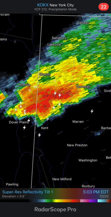
Outstanding photograph -
That cell NE of Springfield is looking nice too now
-
Indeed. Of course the best storms of the season are likely with me out of state for the weekend. Good luck.
-
Idk if that one’s for you, Wiz. I’ve seen this too many times in my location.
-
-
That cell in NW CT is nice.
-
A very boring summer
-
Tropical Storm Bonnie Discussion Number 20...Corrected NWS National Hurricane Center Miami FL EP042022 1000 AM CDT Sat Jul 02 2022 Corrected advisory number Radar data from the Nicaraguan Weather Service in Las Nubes indicate that Bonnie has moved offshore from extreme southern Nicaragua and becomes one of the rare tropical cyclones to cross from the Atlantic Basin into the eastern Pacific Basin. The center of circulation remains well-defined after crossing southern Nicaragua last night, and satellite data during the last several hours indicate that deep convection remains active near the center of the storm. Given the robust structure apparent on radar and satellite, the initial intensity is held steady at 35 kt for this advisory, despite the land interactions during the past 12 hours or so. Bonnie is moving due west at 270/14 kt. The primary steering influence throughout the forecast period is a deep-layer ridge located north of the storm, which is expected to cause Bonnie to track west-northwestward and remain offshore and roughly parallel to the coast of Central America and Mexico. Track guidance is in good agreement throughout the forecast period, and the official forecast is very similar to the consensus track aids and the prior forecast. Although the strongest winds are expected to remain offshore, interests in coastal El Salvador, Guatemala, and southwestern Mexico should continue to monitor Bonnie's track for the next few days, as any northward track adjustments could require tropical storm watches for portions of this coastline. While the well-defined structure indicates that some strengthening is possible in the next day or so, sea surface temperatures (SSTs) are only marginally conducive for intensification and confined to a relatively shallow depth. For this reason, intensification is forecast to occur slowly for the next 24 hours until Bonnie reaches warmer waters in about 36 hours, after which the rate of intensification is forecast to increase. Similar to the previous forecast, Bonnie is expected to reach hurricane strength in about three days, and the intensity forecast is near the center of the guidance envelope. In association with Bonnie crossing into the eastern Pacific, product headers for Bonnie have changed to eastern Pacific headers beginning with this advisory, with the ATCF identifier changing from AL022022 to EP042022. KEY MESSAGES: 1. Heavy rainfall across portions of Nicaragua and Costa Rica will continue today. Life-threatening flash flooding and mudslides are expected. 2. Tropical storm conditions are expected along the Pacific coasts of Costa Rica and Nicaragua within the Tropical Storm Warning areas for the next several hours. FORECAST POSITIONS AND MAX WINDS INIT 02/1500Z 11.2N 86.4W 35 KT 40 MPH 12H 03/0000Z 11.3N 88.3W 35 KT 40 MPH 24H 03/1200Z 11.7N 90.7W 40 KT 45 MPH 36H 04/0000Z 12.5N 93.6W 45 KT 50 MPH 48H 04/1200Z 13.4N 96.6W 55 KT 65 MPH 60H 05/0000Z 14.3N 99.6W 60 KT 70 MPH 72H 05/1200Z 15.1N 102.5W 65 KT 75 MPH 96H 06/1200Z 16.0N 107.5W 70 KT 80 MPH 120H 07/1200Z 16.6N 111.7W 75 KT 85 MPH $$ Forecaster Hogsett
-
-
2022 Atlantic Hurricane Season Tracking Thread
WxWatcher007 replied to WxWatcher007's topic in Mid Atlantic
Watching tropical cyclone genesis is always so neat. 96L was persistent. Now let’s see what happens with Bonnie as it achieves the rare crossover. Although it has underperformed for most of its time in the Atlantic, it has overperformed in the last day. Look at this structure.


