

bristolri_wx
-
Posts
1,482 -
Joined
-
Last visited
Content Type
Profiles
Blogs
Forums
American Weather
Media Demo
Store
Gallery
Posts posted by bristolri_wx
-
-
LOL… gotta love those storms just dying at the RI border every time. It’s like they don’t want to pay those tolls!


-
 1
1
-
-
4 hours ago, WxWatcher007 said:
Is there a place where I can get detailed historical SST plots for the region? This is OT from the heat/humidity/drought, but 26C seems much further north than usual, though there's no depth under that.
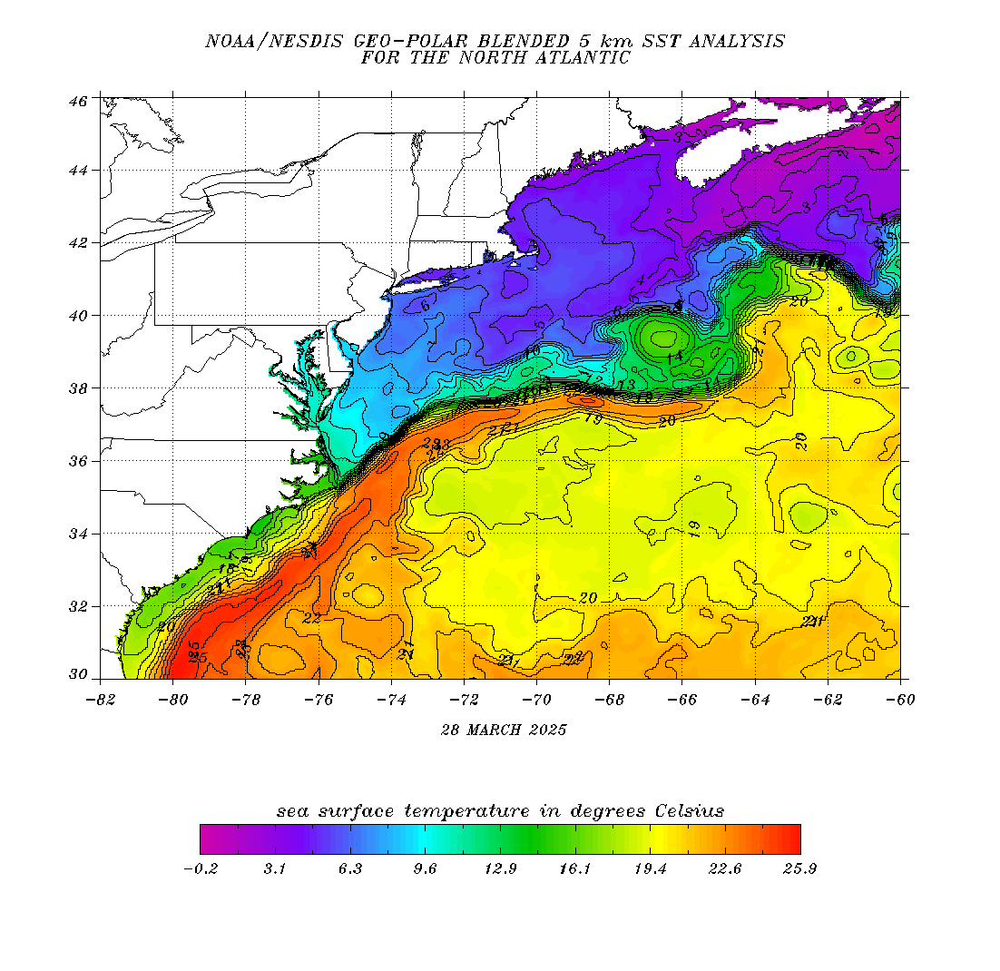
not sure if this is what you are looking for…
-
Not a drop…
-
-
Terrible… and HRRR was no better until about 2 hours until heavier precip was supposed to move in.

-
1 minute ago, Typhoon Tip said:
haha... Heat? In New England, straight through October -
That's never happened because Earth can't do that here. Maybe in the late Paleocene-Eocene Epoch that happened...but then again, that long ago... this region had yet to come out of Plate Tectonics.
We can have hot summers that go into warm falls ..sure... but there are always breaks.
I know, I know... I was being sarcastic there... based on some historical posts in this months thread. That being said, I do remember some one or two week streaks of the HHH's, even if the temps weren't always maxing. This summer has been providing us with noticeable breaks, which is nice, at least IMO.
-
1
-
-
13 minutes ago, dendrite said:
But yeah, the point stands...likely a hot stretch returning. Even though those maps are way overdone.
Yes the ensembles are pointing in that direction as well. One thing to consider that the models haven't been picking up in the extended long range are the "breaks" like today with slightly cooler temps and dew points between the HHH's. Still don't see a "straight through to October" scenario coming as some may have been hoping. Every time you see that unfold on the models in the long range it disappears into some moderating frontal passages in the medium-short range.
-
Well that sucked. Just totally hit a wall and completely dissipated… dang…
-
8 minutes ago, CoastalWx said:
Lol you poor souls wanting storms around here.
Hey I just want some measurable rain
 . Is that too much to ask for lol?
-
4 minutes ago, weatherwiz said:
Can severe rains be a thing and count as severe?
I would gladly take severe rain since I have a hayfield in most of my yard at the moment. It ain’t pretty… reservoirs could use a good drink too.
-
1
-
-
It’s like they are reading this thread at BOX…

645 PM Update: Activity has certainly been less than impressive so far, but we are still seeing scattered thunderstorms across interior SNE tonight with some additional activity trying to get going across RI. Environment remains favorable for thunderstorms tonight with plenty of instability, effective shear, and marginal mid level lapse rates. So why the lack of storms? We think it may be related to the storms that tracked through NYC and Long Island earlier today, which effectively robbed the moisture that was available to feed the storms in our area. That, plus some low and mid level drying behind pre-frontal trough, were probably the main reasons. Going forward, we still expect to see scattered showers/storms tonight ahead of cold front, especially since environmental parameters remain favorable. Some storms could briefly pulse up and become severe, or we may also see small bows or line segments with potential for localized wind damage. Otherwise, wind shift to the NW behind the front which should usher in MUCH drier air for the late-evening/overnight period. Dewpoints upper 50s to lower 60s should be more common in the interior and coastal plain, with lower to mid 60s across the south coast, Cape and Islands by daybreak. Lows to range from the mid 50s to lower 60s north and west of I-95, to the mid to upper 60s across southeast New England.
-
Heard the rumbles of thunder as the storms passed by 15 miles to the north. Sun is out at the moment so maybe some brief heat up of the atmosphere can let that last line move though here with at least some rain!
-
A glimmer of hope still...
Quote.NEAR TERM /UNTIL 6 AM TUESDAY MORNING/... 409 PM Update: Severe Thunderstorm Watch 502 remains in effect until 800 PM, and on the waters/beaches, both high surf advisories in effect for the south coast and small craft advisories. Have cancelled the Heat Advisory, though. While still very humid, limited heating has tempered heat indices to the point where oppressive heat indices are no longer expected. Earlier isolated thunderstorms mainly north of the Mass Pike have shifted offshore in the Gulf of Maine. Additional convection associated with the actual cold front is now making its way into far western Franklin County MA SW into portions of eastern NY. Additional storms were developing in SW CT. These storms remain in a favorable parameter space for severe weather with MLCAPEs in the 1500-2000 J/kg range and effective shear values between 45-55 kt. While storms have been slow to deepen, perhaps a consequence of earlier cloudiness and intervals of light showers and the lack of steeper lapse rates between 850-500 mb, 18z HRRR seems to want to fill this cold frontal convection into a more solid line in the mid to late afternoon as it moves into the I-91 corridor/central MA before moving ESE through the Hartford- Providence-Boston areas closer to sundown. The 12z NAM-3km also wants to do something similar with these storms. Will also have to monitor the widely scattered storms near coastal southern CT for potential thunder risks to the south coast and potentially into Cape Cod. Given the parameter space, stil think we`re not out of the woods as of yet, so have maintained the Watch and the enhanced wording. Still think the bulk of the severe weather risk is through 8 PM, though some of the guidance simulates continued t-storms near the southern coast until late this evening. While not imminent yet, if severe weather evolves the way the HRRR thinks it will into a later period of time, we could consider a local extension of the Watch in time. Will reassess this later.
We shall see...
-
2
-
-
Quote
130 PM Update:

Update to issue Severe Thunderstorm Watch 502 until 800 PM for
all of SNE and upgraded thunderstorm attributes to severe
(damaging winds and large hail).

Shield of mid-level cloud cover across areas south of the Mass
Pike, with most active convection mainly along the NH/MA border.
Recent composite radar imagery however shows some shallow
convective towers getting going in western Worcester County.
Despite the cloud cover, due to high dewpoints in the mid 70s
MLCAPEs are still in the 2000 J/kg range with little to nil
MLCIN to inhibit convection. Steering flow/storm motions is
still from the WSW which should keep active convection in
southern NH to that area for the time being. While these
isolated storms in central MA will continue to move NE into the
Merrimack Valley, as 850-500 mb flow begins to veer to the W,
expect storms to develop and/or shift southeast during the later
afternoon to the mid-evening hours, with guidance indicating
storms making it all the way to the South Coast and even Cape
Cod into early tonight. Damaging winds and heavy rain are the
main risks. A brief tornado is possible, but as flow veers to
the W later this afternoon, that reduces the length of the low-
level hodograph and reduces 0-1km SRH.
Not feeling confident this is going to happen but we still have a few hours for some surprises to occur.
-
1 minute ago, Torch Tiger said:
Looks terrible here, but that was the forecast.
Yup... the radar looked promising this morning with the line of convection associated with the front looking pretty robust in PA and NY... but it hit a wall in southern New England so far.... some cells here and there but overall more
. Not sure what the fuss was about from the various forecasting agencies... maybe I'll reverse jinx myself with this post.
-
1
-
-
HRRR says between 6pm to 1am to get some activity in RI/SE MA. Let's see if that happens. I would just be happy with heavy rain at this point, it's quite parched here, we've missed on almost every rain chance this month except for a couple.
-
1
-
-
Part 2...

-
30 days of high heat in the midwest according to the 30 day GEFS... not as much for us...

-
1
-
 1
1
-
-
I appreciate and love the photos that members post here. Unfortunately in most cases they have been shrunk down to a size that makes them not look great if you want to use them for a wallpaper/desktop picture on a computer, tablet, or phone. I thought it might be a good idea to create a shared Google Drive as a repository to post the full size versions of the photos we're seeing here, for those willing to share. I've already set it up (you get 15GB of storage for free from Google), but wanted to see how others in the forum felt about this.
Here's the link to the shared folder on Google Drive:
https://drive.google.com/drive/folders/1fn4cL9VTB1viOiTYA2-BlsTsxZEzeHIJ?usp=sharingIf members decide that they want to participate, maybe we can create a thread dedicated to photos, or something like that. What I'm looking forward to is being able to use some of these beautiful photos on my desktop as I stare all day at my computer 6 days a week, and hopefully share some of my own as well.
Thoughts?
-
Taking this quick research a step further - going back to 2000, by the last week of September, at least 2/3 of the years have moderate drought or greater conditions covering large geographic areas of New England. So to summarize over the last 22 years:
- Drought isn't unusual in New England in July.
- Droughts lasting large parts of the summer also aren't unusual.
- Droughts usually end in the Fall and Winter for New England.
Not sure where to pull data for time periods for time periods before the year 2000, but heck, it's been dry, but eventually the pattern will change at some point, and it's not anything new.
-
4
-
Been going back through the drought monitor records. I'm not sure why there's so much hyperbole in terms of the dry weather we're encountering. It's not necessarily unusual for the region to be in some sort of drought this time of the year. Seems to be based more on the oscillation of the patterns than anything else. Going back 10 years, about half of them have had large parts of the region encountering drought conditions in mid July.
Their map archive goes back through the year 2000. There was a period between 2001 - 2004 also featured drought conditions in mid July.


-
 3
3
-
-
2 hours ago, ineedsnow said:
temps dropping sun angle starting to lower.. were getting there
Hmm I was not prepared to play the “sun angle” drinking game today. Usually I only have the bottle nearby in February and March!
-
Been watching distant lightning and hearing occasional rumbles of thunder for over an hour now. Northern RI getting the goods tonight. Doubt anything holds together here. Dry as a bone.
-
1
-
-
29 minutes ago, Damage In Tolland said:
Looks furnace and dewy all next week

Isn’t climo for this time of year for Hartford 85/65? +/- 5 degrees doesn’t seem like a “Furnace”… though it’s probably a tick above what I has been on a few of those days.
Lets see if it verifies… you have been posting these almost daily. Looks like a high percentage of Euro input on the extended forecast, which hasn’t been working out too well as of late.
-
3
-


August Discussion/Obs
in New England
Posted
Finally something got through! Came right through town had down ours for 30-45 minutes. Probably around .50”.
EDIT: All stations around me are reporting between 1.25” and 1.50”. Just what we needed!