

Winter Wizard
-
Posts
629 -
Joined
-
Last visited
Content Type
Profiles
Blogs
Forums
American Weather
Media Demo
Store
Gallery
Posts posted by Winter Wizard
-
-
3 minutes ago, jm1220 said:
Nice!! The State College webcams look amazing today.
Yup, it's gorgeous out. It's been way too long since central PA has been a jackpot zone for a Nor'easter. If only this could have happened when I was a student...
-
1 minute ago, WEATHER53 said:
I think Binghamton go 11” in 3-4 hoursbut do t know their total?
Some reports of over 40 inches in that area!
https://forecast.weather.gov/product.php?site=NWS&product=PNS&issuedby=BGM
...SNOWFALL REPORTS...

Location                     Amount    Time/Date       Provider

...New York...

...Broome County...
2 SW Nws Binghamton          42.0 in   1028 AM 12/17
1 SSW Port Crane             41.0 in   0945 AM 12/17   Public
Endwell                      41.0 in   0859 AM 12/17   Trained Spotter
2 E Vestal                   41.0 in   0830 AM 12/17   NWS Employee
2 S Binghamton               41.0 in   0800 AM 12/17   Public
Endicott                     40.5 in   0550 AM 12/17   Trained Spotter
Nws Binghamton               40.0 in   0100 PM 12/17   Official NWS Obs
2 SW Vestal Center           40.0 in   0730 AM 12/17   NWS Employee
-
Anyone down to go golfing today? Jk
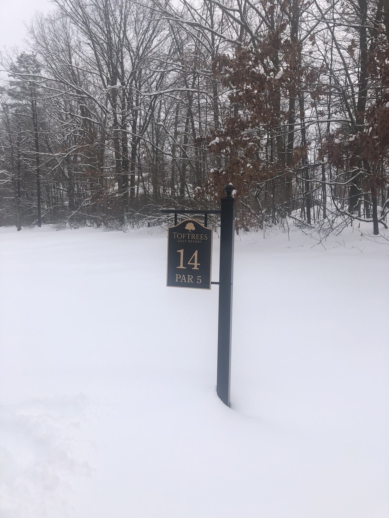
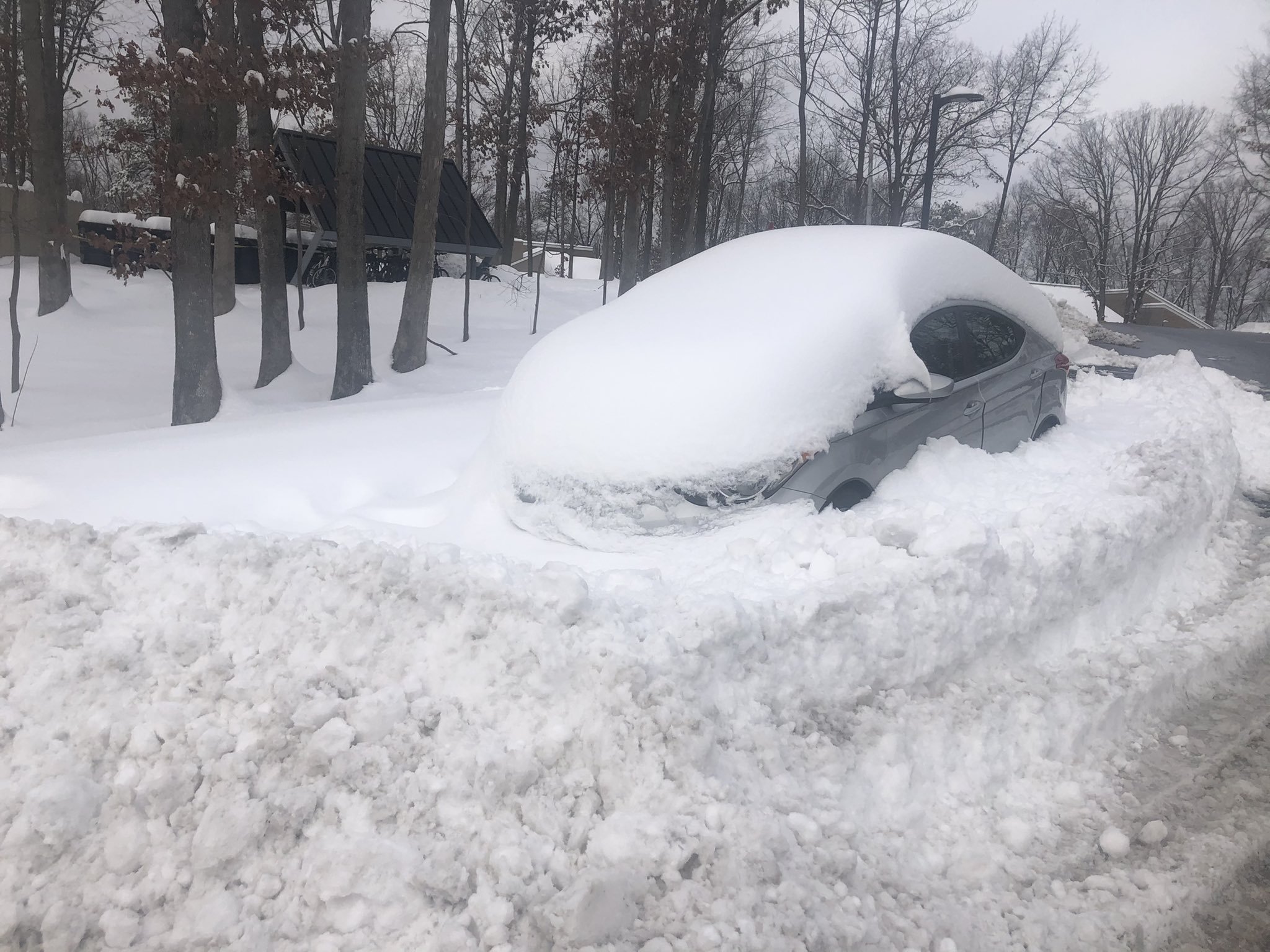
I estimate the final total was between 17 and 18 inches just north of State College- unfortunately my ruler is buried underneath somewhere so can't give an exact total.
A storm for the books for many, hope you guys enjoyed! Well worth the trek back to Happy Valley.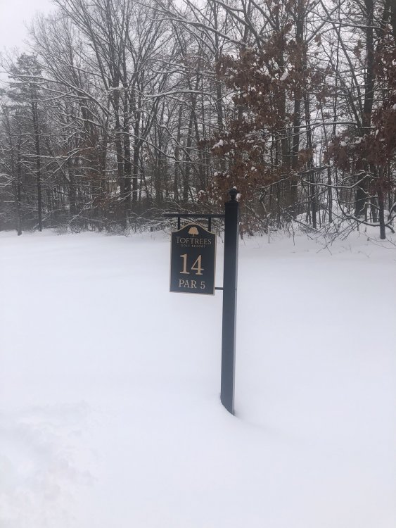
-
 1
1
-
-
Well I ended up making the trek back to State College for this one and it did not disappoint. We weren't quite Binghamton, but I estimate we got around 17-18" of powder. Going to be bittersweet heading back home to Maryland, but after missing out on the Blizzard of 2016, I am quite content.
Hope y'all that still cashed in enjoyed and hopefully we'll have more chances in the coming weeks.
-
9
-
-
Last measurement in State College was 14.5” around 12:30. Still moderate snow falling.
-
1
-
-
Calling it a foot in State College as of 9:30.
-
2
-
-
Close to 5" as of 5:00 and even heavier rates than before.
-
2:30 update:
+SN, 2.5" on the ground in State College. Visibility under 1/2 mile with the best rates of the day.
-
1
-
-
2:30 update:
+SN, 2.5" on the ground. Best rates of the day so far.
-
2
-
-
0.8" in State College as of 12:40.
-
The initial snow band means business, solidly -SN and already have light accumulations on all surfaces.
-
Snow has commenced in State College. Earlier than expected.
-
Had to make the trip back to Happy Valley for this storm! Looks like for the first time in a long time, this entire subforum will be the jackpot zone, hope you all enjoy.
-
4
-
 1
1
-
-
I'm not sure if this was ever mentioned in this forum, but this always struck me as a red flag that there would be an adjustment northwest. Goes to show you how subtle changes to features in the atmosphere could have significant implications downstream.
-
2
-
-
1 minute ago, clskinsfan said:
It has been an incredible drought for them out there. Looks like a great spot for this one though.
Yup, they haven't had over a foot of snow since February 2010 - always stuck too far northwest for the Nor'easters that crushed I-95. But climo had to win out eventually.
You should be in a pretty good spot out in Winchester too.3 minutes ago, Cobalt said:Didn't they fare rather well in the March 2017 storm? This storm feels like it has an uncanny resemblance to that one. In fact our airmass is probably way worse, but of course that's a March storm rather than mid December.
We got 10.1". Solid but pales in comparison to NEPA. November 2018 was better with 11.5".
-
2
-
-
41/22 in Annapolis.
Decided I'm going to head back to State College for this storm - hoping they finally get crushed after being fringed so many times this decade.-
1
-
-
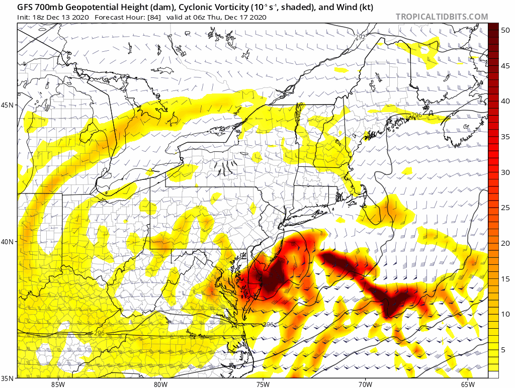
GFS is slightly warmer in the mid-levels otherwise there isn’t really a discernible difference from 12z.
That being said, won’t do anything to reduce the tension in this thread lol.
-
4
-
 2
2
-
-
Quite a SE shift on the H7 track...this would make just about all of the forum, including those near I-95, very happy.
-
5
-
-
The PNA is slightly more amplified out west through 60 hours compared to 18z. No significant changes in the east.
-
1
-
-
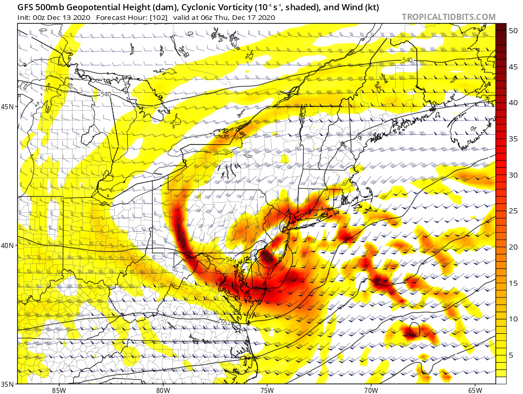
This H5 look at hour 102 is absolutely classic. If it can close off slightly sooner and/or farther south, I think just about everyone in this forum will be very happy. The deformation zone would be pretty sweet verbatim.
I think it’s pretty clear the 18z GFS that caused weenie suicides was just a blip; the GEFS suite being east was a red flag. What’s encouraging is seeing the vort pass through sooner, which prevented higher heights from building in the Atlantic. This is key for allowing the system to take an offshore track rather than move too close to the coast, as well as not completely torching the mid-layers. Hopefully the Euro and it’s ensembles can follow suit.

-
7
-
-
Lots of west leaning members here, tread carefully.
-
1
-
-
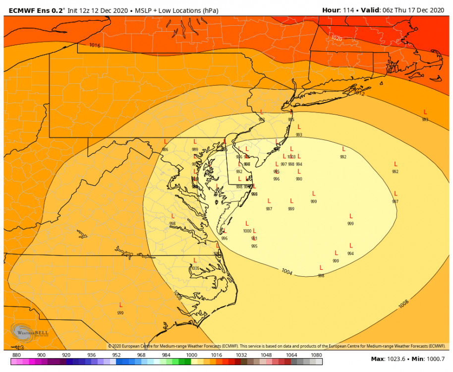
Not sure if I’m allowed to post, but the EPS is clustered farther west than the operational.
-
1
-
-
5 minutes ago, psuhoffman said:
I looked at the EPS members. There is a relationship.
I identified the 7 most amplified members for Monday and 6 of them had the most south/cold solution for Wednesday. Those 6 had the axis of heaviest snow south of DC. Some were a total miss south. The 7th had a weird all NS solution with not much of a storm anywhere.
Inversely the 11 members that I pulled as being flat and weak Monday had the warmest north solutions Wednesday. 9/11 were north of the mean Wednesday. And the 2 most suppressed Monday members were by far the most extremely north members Wed.
Obviously this isn’t scientific but it seems on the Eps anyways a more amplified system Monday leads to a colder solution Wednesday. Less obvious is any correlation to the amplitude or organization of the Wed storm. There were amplified but qpf producers in both camps. Some weaker in both. But the warm/cold correlation was like 90%
Thanks for checking on that, seems to be in line with my hypothesis. The closer the timing between the two systems, the more of a relationship there will be.
-
2
-
-
4 minutes ago, WxUSAF said:
@psuhoffman I know you said yesterday the outcomes for Monday and Wednesday seemed unrelated. But seeing guidance move in lockstep for both storms today has me wondering...
If there is any relation, I would maybe think a weaker, flatter system Monday would allow for a stronger Atlantic ridge to build ahead of wave 2. Would need to take a closer look and see if there's an impact.


December Banter 2020
in Mid Atlantic
Posted
January 2000 is the ultimate example of a positive bust in our area. The storm was predicted to go out to sea but instead continued northward and dumped over a foot of snow across much of the area. As @MillvilleWx alluded to, NWP models have substantially increased in accuracy since then, so such a large-scale bust likely won't happen again. November 1987 I imagine was a similar type of positive bust.
November 2018 is also a good recent example: the storm ended up colder than expected, so areas along I-95 and north and west got quite a bit more than forecast.
December 2013 is a different case since that was the result of a mesoscale band in an area of strong convergence. - those types of busts can still happen as models have still have difficulty pinpointing the magnitude and location of those bands. Just ask Binghamton, for example. In February 2009, there was an inverted trough that set up near Philly and dropped a surprise 8 inches over the city.