

Winter Wizard
-
Posts
629 -
Joined
-
Last visited
Content Type
Profiles
Blogs
Forums
American Weather
Media Demo
Store
Gallery
Posts posted by Winter Wizard
-
-
6 minutes ago, Ginx snewx said:
Coastal.is developing at 989 off Delaware, late? That's classic here
Primary is still nuking over Lake Ontario at that point.
-
Cut that Kuchera map down by at least half, front end is going to be paste. Back end, sure, you'd see 12-15:1 ratios most likely. Even though it's a very nice run for the Pike region, I don't think it does much to quell concerns: you get a quick front end thump and then you're banking on fickle IVT snows from a late developing coastal. Flow is still very progressive.
-
 2
2
-
-
34 minutes ago, ORH_wxman said:
06z eps looking good. Maybe a little north of 00z
Looks like the east leaning members converged back to the west. Going to introduce p-type issues near the coast if that holds.
-
 1
1
-
-
Yesterday's runs were Goldilocks solutions and I don't think it's surprising at all that if you adjust the timing and positioning of certain features, all of a sudden the ceiling becomes much lower. Not saying this is a similar progression as what we saw in mid-late December, but it's a good reminder that the setup can be textbook but if certain pieces are misaligned, then it won't come together. All in all, with how this winter has gone, I don't think you can complain about a 6"+ mean with this lead time.
-
3
-
-
I would be much more concerned about a whiff north than missing south. The primary decays a bit too late for me to feel comfortable and the tendency this season has been to weaken confluence over Canada.
-
3
-
-
It's a pretty bizarre evolution and IMO the primary decays a bit too late for my liking. Having the -NAO and pivoting 50/50 Low certainly does raise the bar for if/where this develops.
-
37 minutes ago, SnoSki14 said:
We're definitely not seeing that type of blocking. At best it'll be an east based -NAO.
Heights look very low over and around Hudson bay & southern Canada because that's where a portion of the TPV will hang.
Agreed, this does not look close to December in terms of magnitude of the blocking. NAO is much more meaningful for Europe than the US anyway. Certainly strong agreement that Canada will be chillier than normal but not sure how much of that will seep into the US besides the Upper Midwest and the Rockies.
-
2
-
-
Just now, snowman19 said:
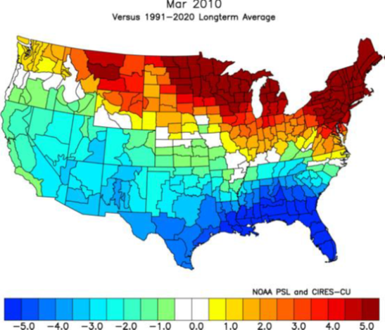
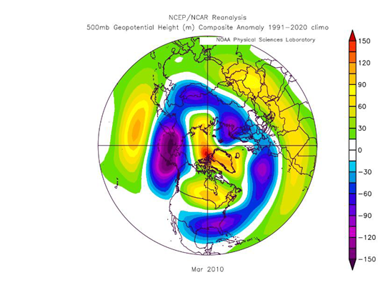
If we are going to see a turnaround in March the blocking has to show up come the 1st week, and I mean legit blocking in the NAO and AO domains because the PAC is still going to suck then. Then we start racing against the clock. If the blocking starts getting delayed beyond the 1st week of March, I think we’re done. I consider 3/15 the cutoff for anything other than a freak event at our latitude, there’s too much working against us cold and snow wise at that point and beyondMarch 2010 is a great example of how a -NAO block in March far from guarantees a cold pattern developing. If you look at the other cold/snowy March cases recently that had NAO/AO blocking, it was because there was help in the Pacific domain. Currently I'm hard pressed to see the Pacific working in the East Coast's favor for the foreseeable future.
-
4
-
-
The 2/23 threat definitely has legs in New England, IMO. Key difference from December is now we'll have the 50/50 this time in addition to the -EPO and an east-based NAO block. You can certainly thread the needle with that depiction but the timing is delicate: if it comes in too soon, then this will be sheared and suppressed, but too late and this is another cutter.

-
2
-
-
For reference, at this time on 2/13/16, BOS was 12 degrees
https://www.wunderground.com/history/daily/us/ma/east-boston/KBOS/date/2016-2-13-
1
-
-
I feel decently confident in saying that with the delayed movement in the front, BOS will go below -10 tonight.
-
3
-
-
5 minutes ago, snowman19 said:
I doubt we score in the 2/1-2/7 time frame. No -NAO or 50/50 low. I think whatever happens is an inland runner. This winter is on life supportYou can still score a decent overrunning event if things align correctly, but those usually favor New England. Does not scream KU though without those features.
-
2
-
 2
2
-
-
The upcoming pattern certainly seems like December deja vu. EPO block rivaling December's (which has trended stronger every day since 0z Thursday) will dump the extreme cold into the N Rockies and Plains but will struggle to make it to the East Coast until probably the end of next week thanks to the SE ridge. Then there will be a few days below average, but as blocking retreats, we return to the canonical Nina pattern and I think the Northeast torches yet again while the West is cool and stormy. If things align, I think there could be a good opportunity to score something in the 2/2-2/7 timeframe as the Metro rides the boundary between polar cold to N and W and the lingering SE ridge, but after that, I don't see much to be enthused about.
-
3
-
3
-
-
At first glance, I could see this playing out similarly to the Super Bowl storm last year, which clocked the South Shore, in a high end scenario. Certainly have a pronounced FGEN signal but soundings show a good amount of dry air in the mid-levels.
-
2 hours ago, snowman19 said:
The models have backed off the extent of the cold 1/21 on. Canada is going to be completely full of Pacific Martine air and it is going to take quite awhile to build arctic cold back up again without cross polar flow. It looks like NYC is going to make it to 1/20 without its 1st inch of snow. That has only happened a total of 15 times in the entire weather record keeping history of the cityIMO the cold period, if it does happen, wouldn't be until the 28th or so. I suspect the back end of January follows a similar progression to December where the West cools down first once the Asian-Pac jet relaxes, likely around 1/20, then slowly progresses eastward. After that, Nina climo generally favors a return to a -PNA pattern and strong SE ridge for February. It isn't pretty.
-
4
-
-
Pretty clear differences between the EPS and GEFS evolution...EPS has a notably stronger -PNA signal which enhances the SE ridge and takes the mean storm track farther N while the GEFS is neutral to slightly positive. You would want that parent low to decay sooner, closer to OH/KY border rather than MI to get any appreciable frozen precip into the Mid-Atlantic. Even then, it would favor the typical climo areas - at the current depiction, it's difficult for me to get enthused if I lived near the coast.


-
2
-
-
2 hours ago, H2O said:
Based on the last two weeks of incessant model posts of things 240+ hours away my thoughts have been this
12/5-12/10: pattern starts changing from mild to seasonal or BN
12/12-12/17: storm chances increase, too early to know precip type
12/20-12/31: pattern stable or RELOAD?
If I’m wrong someone let me know. If it wants to snow after the -AO/NAO sets in then great but D+7 models won’t know until mid month
I'd probably push the first two windows back a few days, otherwise this seems pretty solid to me. Models have had a very tough time handling the Pacific so far this Fall and have been too quick to erode the -PNA again. I'm optimistic that we'll at the very least go neutral by 12/20 while EPO turns back to the negative phase and blocking retrogrades to the Hudson Bay. That's a pretty good look for some potential late month fireworks but no doubt there will be more meltdowns before then.
-
2
-
-
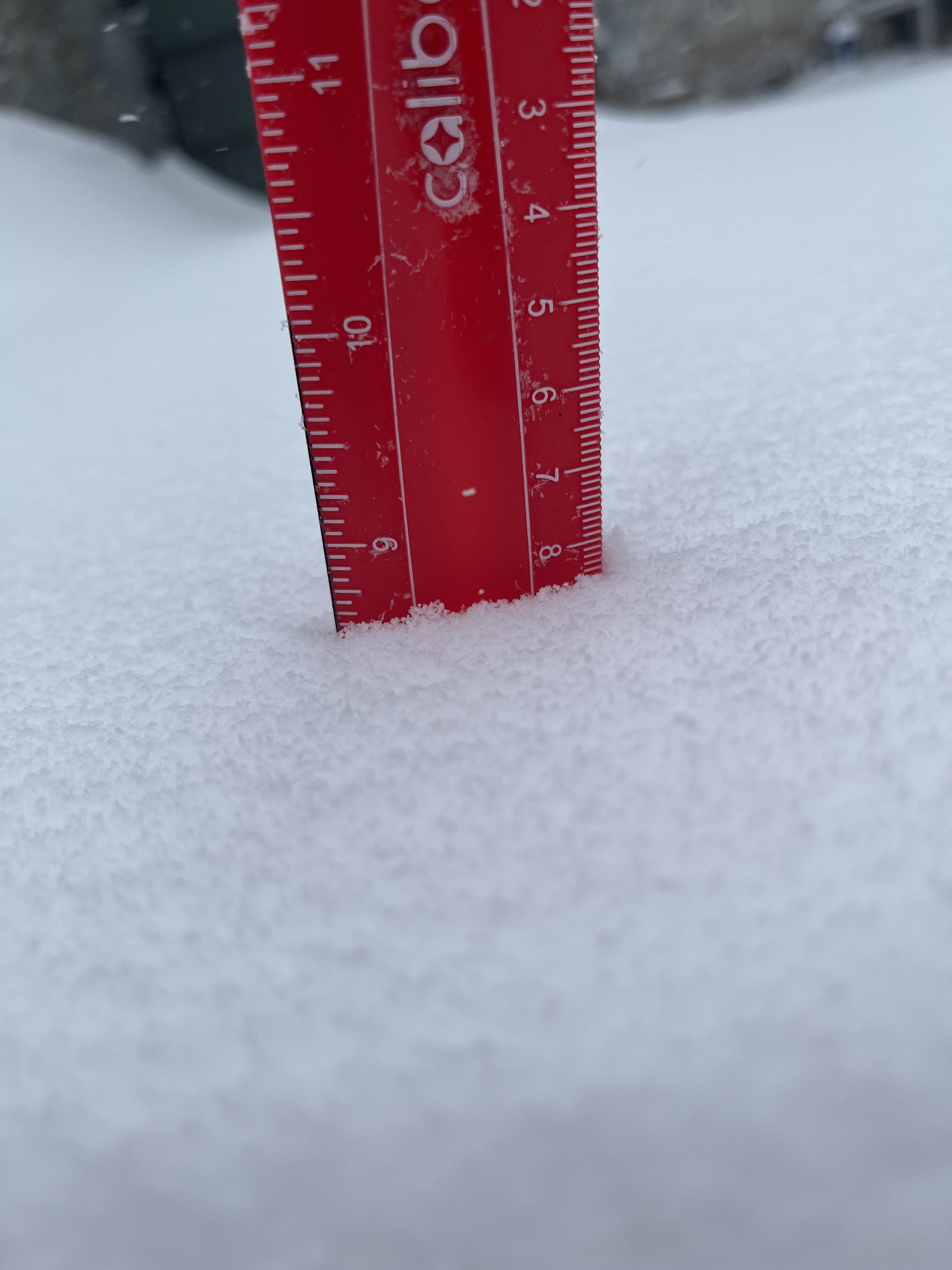
Right around 2” here in West Somerville, maybe a bit more. Slow start but ended up exceeding expectations.
-
Stuck in the screw zone here in downtown Boston.
-
Surprised to see so little discussion about Wednesday. Easily could be a moderate event for southern regions.
-
Unless we tack on a few tenths this should be the final total. Solid storm.

-
1
-
-
The CF is pretty solid here in Somerville. Probably above 8” at this point.
-

Hi-res guidance is pretty insistent on some OES this afternoon and evening. Maybe we squeak out another inch or two along the eastern MA coastline? -
7.3", sleet.


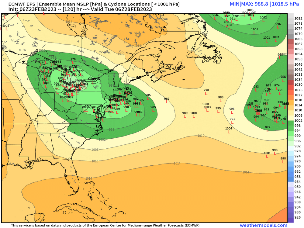
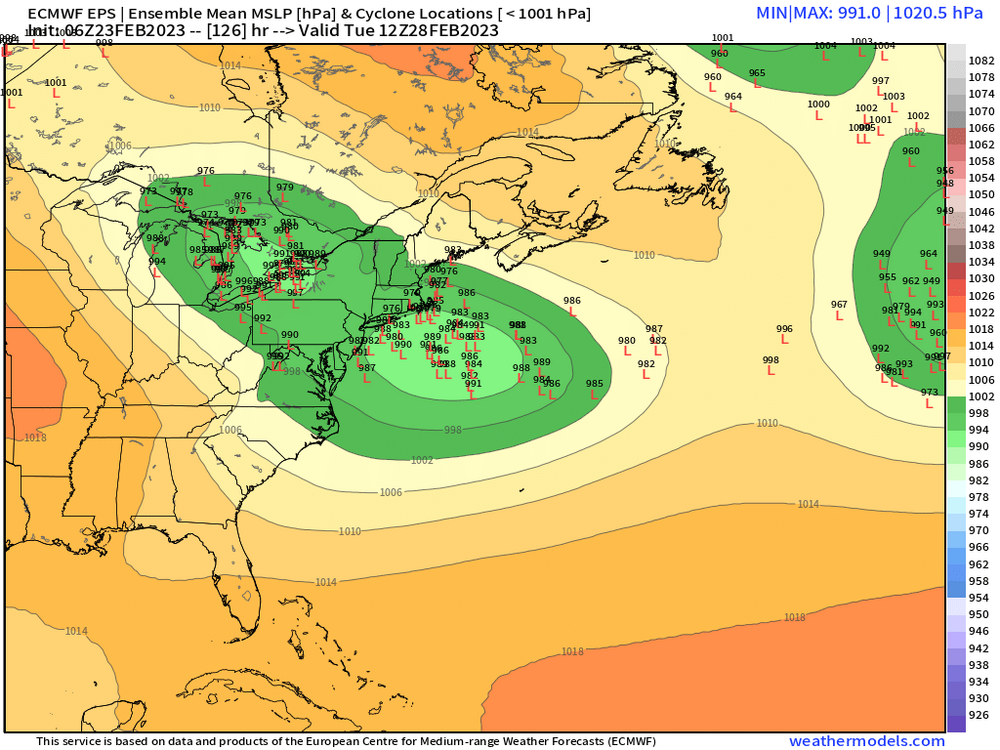
Feb 28th-March 1st long duration Miller B threat
in New England
Posted
I don’t have reanalysis handy, but how does this setup compare to 2/9/15?