

Winter Wizard
-
Posts
629 -
Joined
-
Last visited
Content Type
Profiles
Blogs
Forums
American Weather
Media Demo
Store
Gallery
Posts posted by Winter Wizard
-
-
Confluence is a bit weaker this run, I expect a tick back to the north. Also a little stronger.
-
 1
1
-
-
2 minutes ago, Franklin0529 said:
A weaker storm isn't going to cut it I don't think
Nope. The low center is 2 mb weaker and a bit east, but the rain-snow line is more N and W. I reiterate what the other mets have said that this is very much thread the needle between conflicting variables. You need to simultaneously balance being amplified enough to send in the best dynamics and not be squashed by confluence, but also not torching the mid levels with strong easterly flow. Extremely difficult to pull off in this setup. Interior is a different story, this should be nice for the Poconos, NWNJ, and I-84 corridor in NY.
-
5
-
-
OH Valley primary low looks weaker and north and Canadian high retreating a bit sooner. Hour 102.
-
OH Valley primary low looks weaker and north and Canadian high retreating a bit sooner. Hour 102.
-
1
-
-
8 minutes ago, CoastalWx said:
Definitely notable on the confluence. Probably helped drive that s/w north.
Agreed and at a certain point we have to be careful what we wish for. Unless there's a windshield wiper back, I think it's totally plausible for this to keep moving north and west to the point where perhaps BOS, PVD, and HFD are in danger of mixing. Curious to see what the ensembles and the Euro suite show, but I've been more concerned about an inland runner vs. suppression.
-
2
-
-
Two notable trends here: notably less confluence over Atlantic Canada and a less amplified western US trough.
-
1
-
-
Euro looks like deja vu from this week but with an even stronger storm. Deluge to heavy wet snow is certainly a plausible idea for the interior depending how the low occludes.
-
1
-
-
Don't think anyone on the outside is missing much. Marginal temperatures and snow growth looks poor. I think any accumulations on the South Shore would be pretty localized.
-
1
-
-
Sunday-Monday storm looks pretty solid for the ski resorts IMO. Would also watch late week for one of those sneaky waves to come down the leeside of the trough and bring some light snow to spots.
-
Looks like a brief window for a bit of early season fun from just after Thanksgiving into the first couple days of December. Obviously a lot needs to line up, but with a -EPO and now a +PNA (which was a big reversal yesterday), we may get some BN anomalies for a time coupled with the active STJ. The driver of this is a major reversal in global wind to the negative phase, which will actually put us in a La Nina esque regime for a time, similar to what we saw around Halloween. My hunch is this is temporary, maybe a few days then we return to a torch pattern through the middle of the month.
-
1
-
-
1 minute ago, Eskimo Joe said:
The downside to this event is that we need the higher end potential to be realized. It's been hyped so much now that for this to bust would erode public trust.
It's an overblown concern IMO, people say that after every storm.
-
5
-
 1
1
-
-
I think all systems are a go for one of the most significant severe weather outbreaks in our region the past few years. Skies are clearing so CIN is quickly eroding and our atmosphere is destabilizing, we’ll see if any crapvection fires out ahead - that’s probably the main limiting factor at this point. Kinematics still look quite favorable for some discrete cells to pop off the Appalachians this afternoon and I do think the tornado potential is legitimate especially those of you outside the Beltways. Linear storm modes are favored by the time you get inside the Beltway and east and we’ll be looking at a widespread damaging wind event. I am concerned about the potential for tens if not hundreds of thousands of power outages once this moves through. Hope everybody is safe, this is looking more and more like one for the books.
-
13
-
-
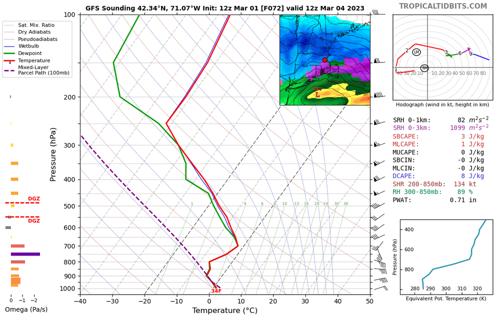
This is one of the better tornado setups I can recall in recent year in SNE. I think the weak lapse rates, and discontinuity between best shear and instability will limit the spatial coverage but there should be a few pretty potent storms. Clearing looks to be happening as expected below Concord, NH.
My hunch is SPC is too far north with the tor risk, this screams CT to western MA jackpot to me.
-
1
-
2
-
-
2 hours ago, Ginx snewx said:
The volcano fuked us. Research showing correlation with neg PNA is out.
Do you have a link to this? Would like to take a look.
-
1
-
-
NAM 3K is definitely coming west.
-
Haven’t had time to look at anything since, but this is my first call map from this morning. Should be a fun one for most of you!

-
7
-
-
Way too bearish IMO. Big storm incoming.
-
3
-
1
-
-
You basically have the full repertoire of outcomes on the table here...I suspect we're seeing the classic progressive GFS bias and Euro overamped bias at play here. Way too early to have any confidence in a call, but need to closely watch the interaction between the two streams: if the northern stream comes racing ahead then this will be a late bloomer scenario. If the southern stream races away then you get a much stronger storm initially and inland runner is on the table. Both scenarios seem equally plausible at this point, in my opinion.
-
3
-
-
6 minutes ago, UnitedWx said:
Looks fine to me over here, but this isn't done wobbling one way or the other
Even out there I see concerns with snow growth on the soundings. Certainly will continue to see wobbles in either direction, and I'm not saying that's the apt solution, but it shows just how quickly this threat can fall apart by only a slight margin of error.
-
1
-
-
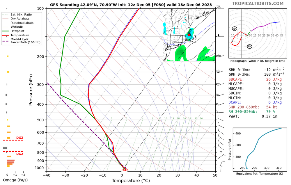
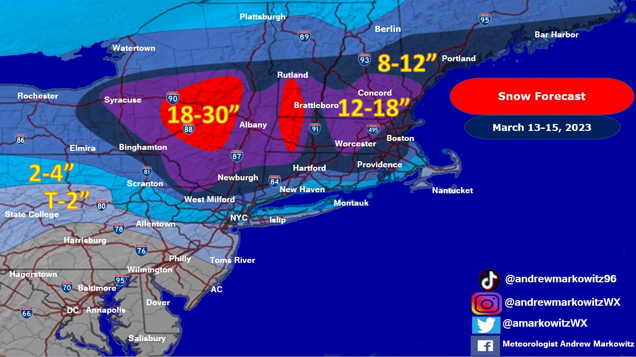
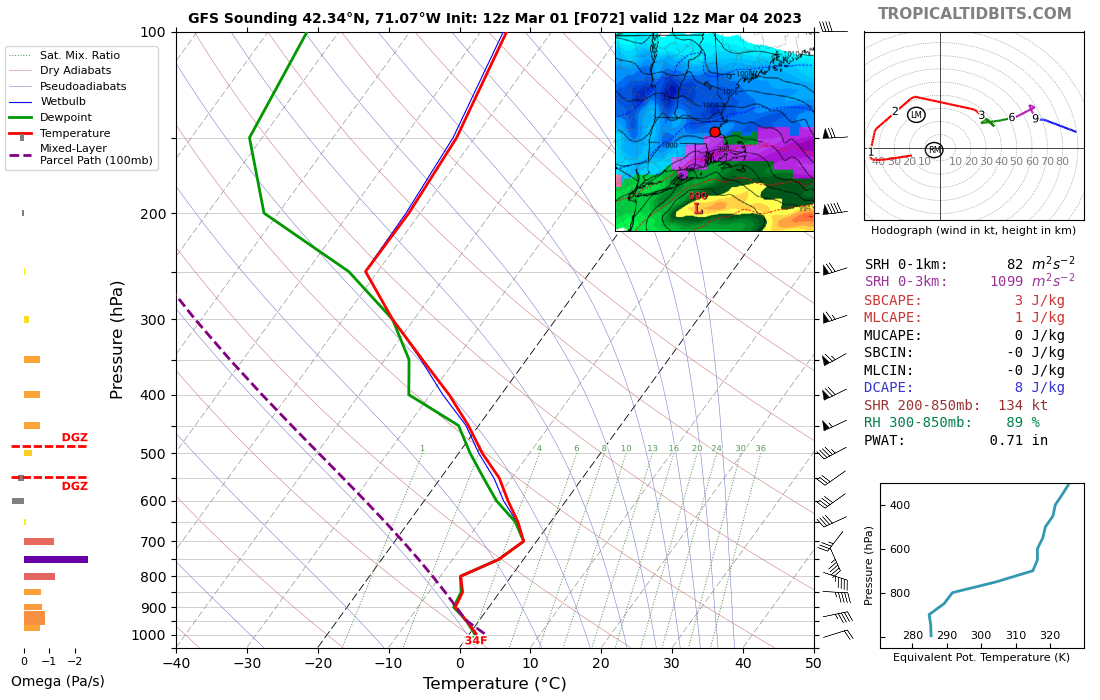
Gotta say this sounding isn't doing very much for me...not only do you have the warm nose within a margin of error, degree wise and temperature wise, but snow growth is unimpressive after an initial front end burst. Would exercise caution about using the Kuchera map here, as usual.
-
2
-
-
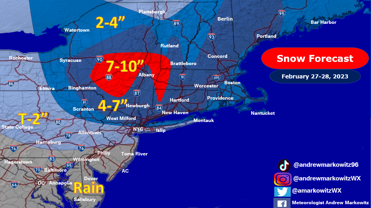
This was my map from this AM, no major changes after looking over today's guidance. If anything, would trim eastern Mass some (T-2 for the immediate coast and the Cape).

-
9
-
-
Lol you kind of get the worst of both worlds on that Euro, most of the region misses out on the WAA thump then the confluence shunts the coastal low to the southeast. NNE is smoking cirrrus.
-
I actually thought the GFS was an improvement, farther N and W with the primary low and then weaker confluence to the north provides a bit more coastal enhancement. That's still good for a widespread 6-12", in this winter I certainly would be happy with it. Would be a quick mover though without any mechanism to slow it down, unlike those wild solutions from yesterday.
-
2
-
-
A warning event is still very much on the table for most of the forum and would be a huge victory with how the winter has gone. There have been clear modes of failure with this one to prevent it from becoming a big dog.
-
3
-

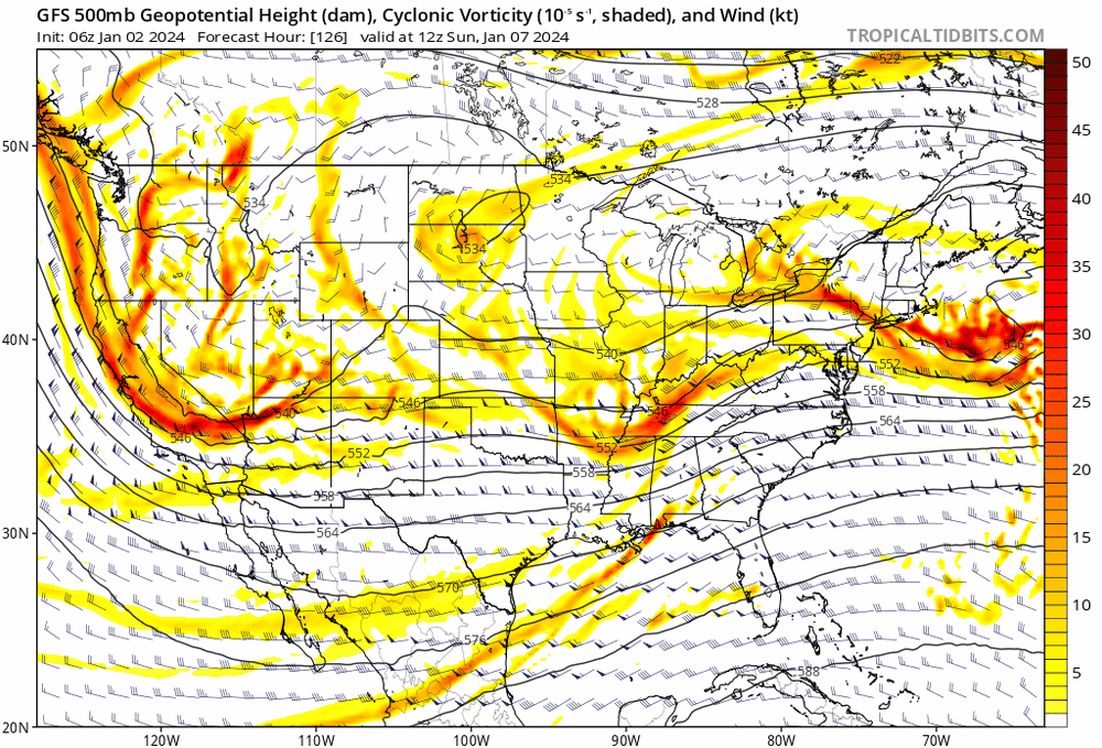
Monitoring first regional significant winter impact event. Magnitude likely tempered. At this time NE PA/SE NY and SNE primarily. Jan 7/8.
in New England
Posted
Yep, exactly, all of those pieces are working in tandem which makes this complex. Putting it together, I think these are subtle but noticeable improvements across the board for most in this subforum.