

hudsonvalley21
-
Posts
3,870 -
Joined
-
Last visited
Content Type
Profiles
Blogs
Forums
American Weather
Media Demo
Store
Gallery
Posts posted by hudsonvalley21
-
-
7 minutes ago, EMontpelierWhiteout said:
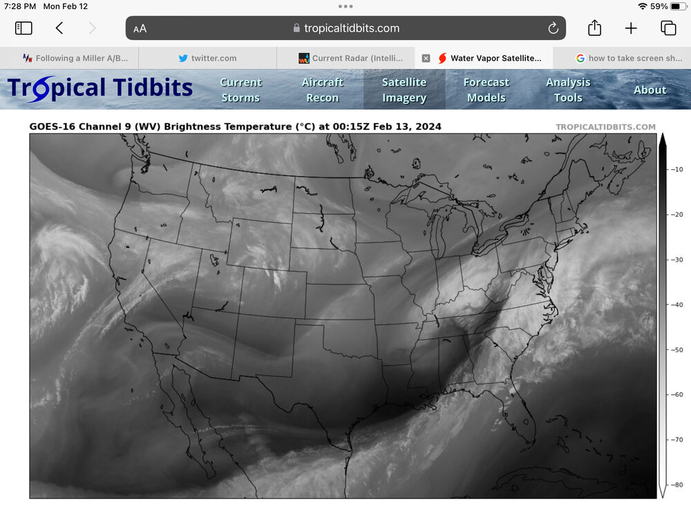
Also, center of circulation appears to be more in western third of Tennessee rather than eastern half depicted by 7:00 PM GFS and Euro modeling position.
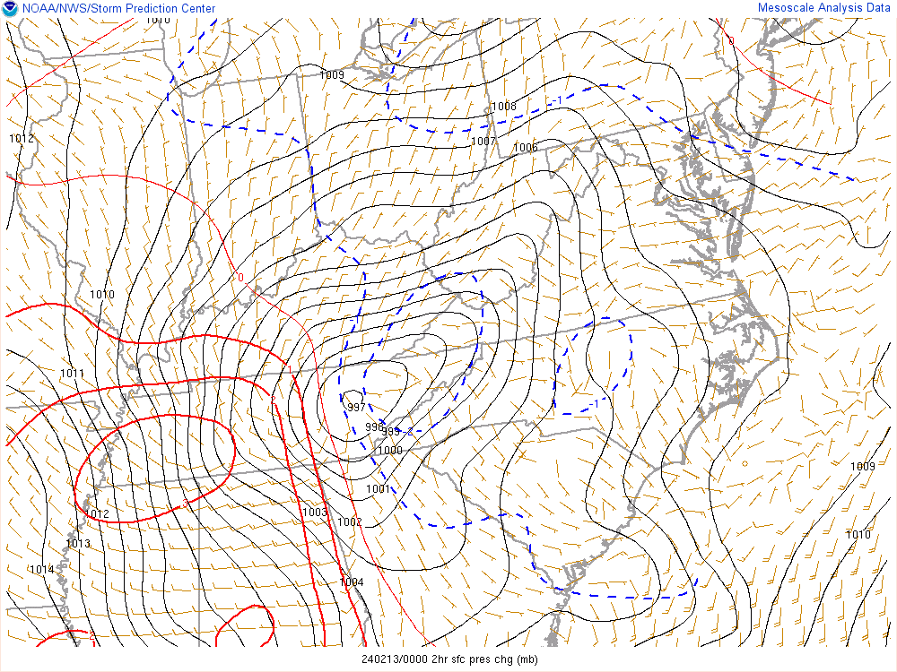
2hr pressure drop map
-
Just now, Yaz said:
I saw this also. So, I looked at the soundings over the suspiciously green areas and they indicate snow profiles, not rain.
Strange indeed. All other models are showing snow ptype
-
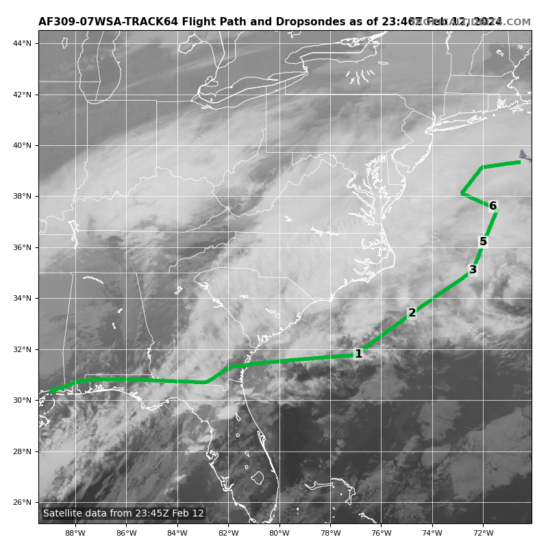
Interesting that they have a recon sampling in the open waters.

-
 1
1
-
-
2 minutes ago, weatherwiz said:
18z euro about to roll out soon, right? Going to set the toaster oven up next to the bathtub and fill it with just enough water to cover my scrawny little body

-
 5
5
-
-
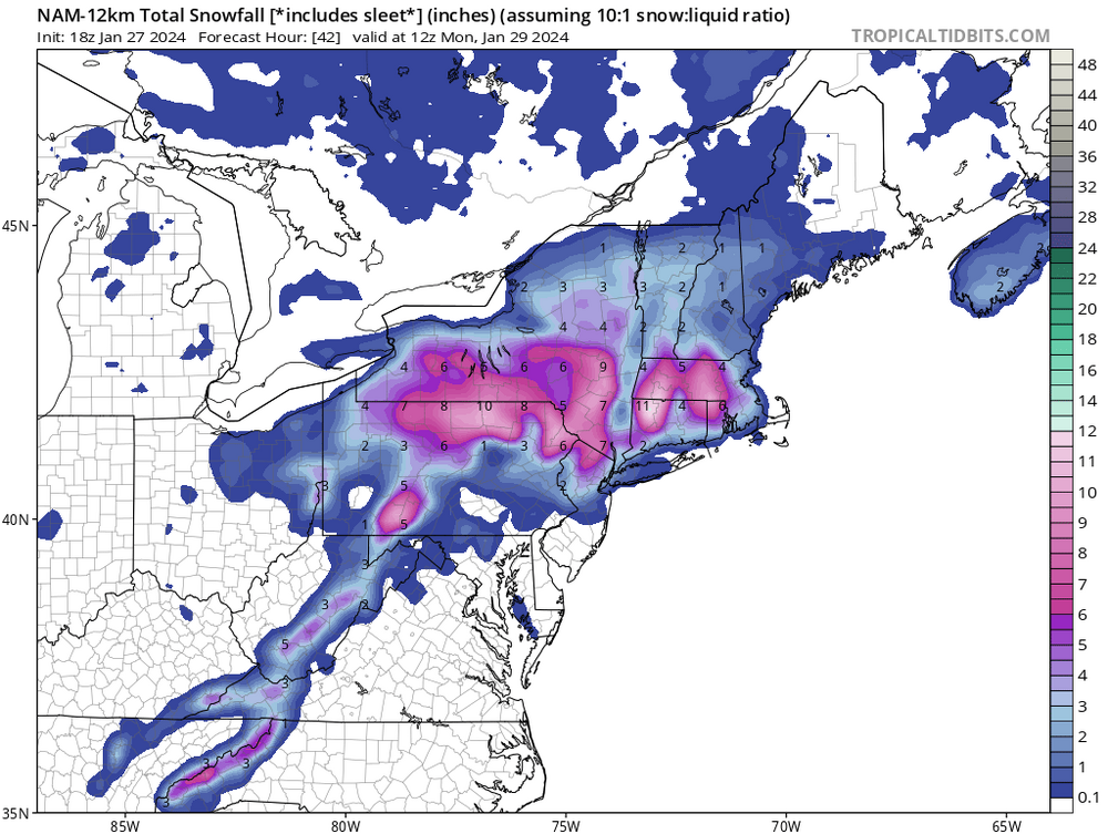
34 minutes ago, jm1220 said:
GFS is an absolute crushing from about dawn through noon. Wow.
Funny how it’s showing rain on the backside

-
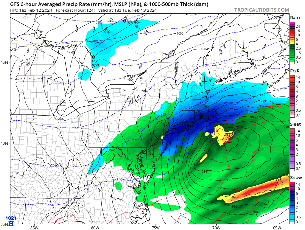
Borrowed from the New England thread,
-
1
-
-
Just now, donsutherland1 said:
12z was 4.1” at SWF.
Thanks Don
-
5 minutes ago, RU848789 said:
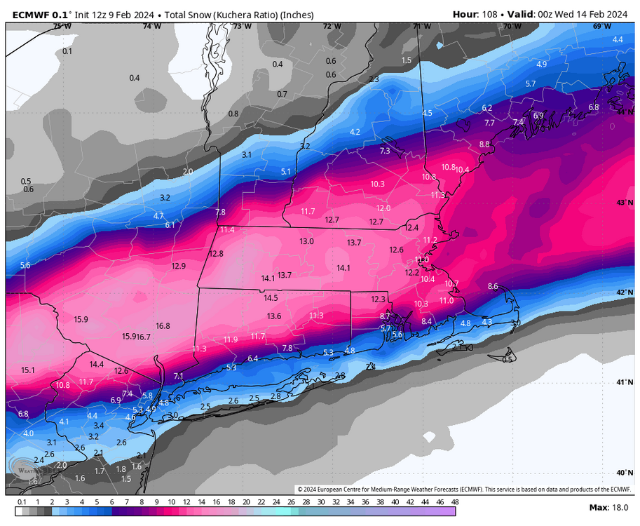
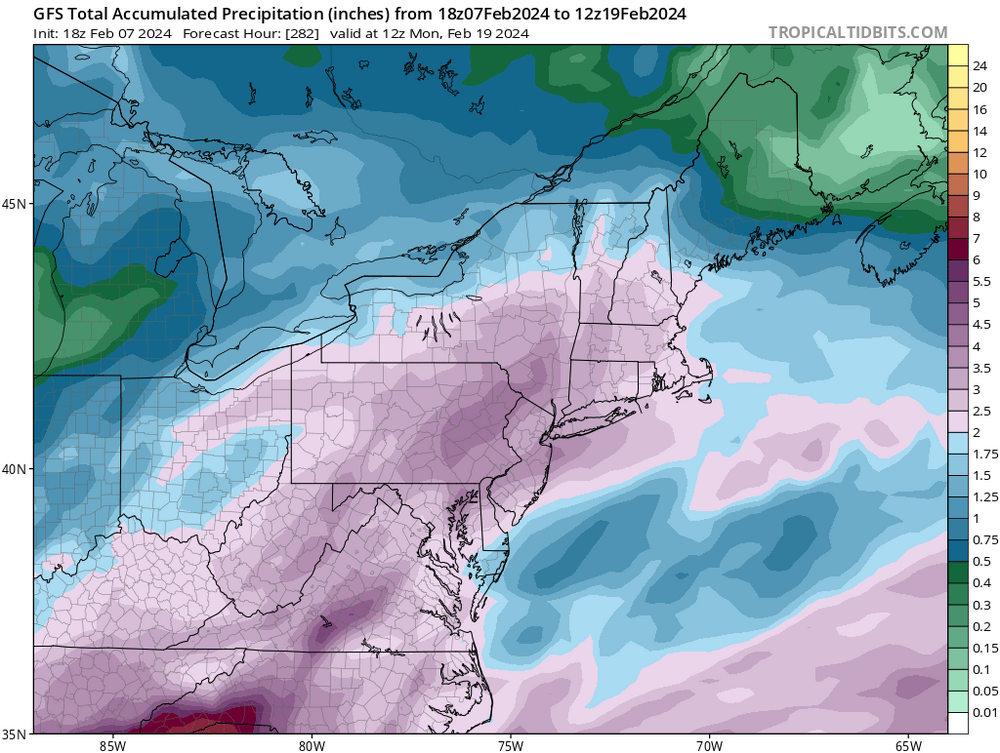
If the 6Z GFS is correct for Trenton to NYC along 95, for example (and we have no clue), it's showing 7-8" of 10:1 snow falling from the sky from 10 am to 4 pm with good looking DGZ snow crystal formation/growth, column temps well below 32F until very close to the surface and surface temps around 33F. Verbatim, that snow is ;likely going to accumulate easily at over 1" per hour rates and will likely do better than the Kuchera algorithm, which treats a 1500 foot deep 33F layer aloft the same as it does a shallow 300 foot 33F layer right at the surface (it only takes max column temp into consideration, not depth=time at that max temp) and those aren't the same, as less partial melting will occur in the latter case, meaning less compaction and loss of good ratios. If the GFS is correct.
Interestingly, the GEFS shows warmer surface temps of 35-37F during the event, but since it's showing a smoothed mean of many members, the ~6" of snow it shows falls over 9-12 hours, so at maybe 0.5" per hour, which is not nearly as dynamic and that could be why there is less cooling at the surface; at those temps during the day and at lower intensity, though, one would expect a fair amount less snow to accumulate. One would think the Op is more likely to show dynamics better than the ensemble mean, though.
Intensity is going to be so important for this storm if the GFS is close to right, especially during the day...
Nice write up. It will be interesting when the short range models such as the HRRR and HRDPS are in range.
-
1
-
-
1 hour ago, donsutherland1 said:
Recent NBE estimates for NYC:
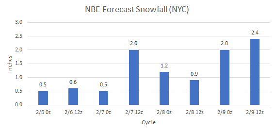
Don, does it have estimates for other locations inland such as KSWF?
-
1 hour ago, NEG NAO said:
18Z GFS clown map

And a general 2-3” of QPF thru 274 hours. And as we know this will flip flop like a fish out of water for the next runs. Some better sampling in the next few days will get a better read.
-
33 minutes ago, AstronomyEnjoyer said:
@Prismshine Productions Where are you? I need backup. Getting absolutely destroyed in here.

-
22 hours ago, IrishRob17 said:
Had a trace last night at some point, I saw remnants of it on the driveway where it goes over a culvert
Same here. Also heard that the speed was reduced on the Newburgh-Beacon bridge and it was treated for icy conditions.
-
1
-
-
DCA _ NYC _ BOS __ ORD _ ATL _ IAH __ DEN _ PHX _ SEA
1.5 1.2 1.4 1.4 0.3 2.1 1.6 1.1 -0.4
-
9 hours ago, IrishRob17 said:
I had nothing aside from a flurry here or there overnight, no new snow to report for me this morning.
1.26” was the total in the Davis for the event. A dusting of ice pellets this morning here. I see that up on Storm king at 700-1000’ it was snow covered. Not sure what was actually accumulated tho.
-
34 here with just plain light rain. Had a mixed bag about an hour ago during the heavier precipitation at 125’ of elevation. 1.01” in the Davis so far in precipitation.
-
1 hour ago, CPcantmeasuresnow said:
33.8 mixed snow and rain continues. 600 msl. Highland mills eastern Orange County.
34 here with just plain light rain. Had a mixed bag about an hour ago during the heavier precipitation at 125’ of elevation. 1.01” in the Davis so far in precipitation.
-
21 minutes ago, wdrag said:
I'm at 740'MSL. You'll know seeing my reports or those of nearby Vernon on mPing between 7and 9A in north central SC, whether our thinking will work I'm counting on 2" slushy snow here at this Wantage elevation and probably 4-5" total Vernon and High Point. This might be high per NBE? You're thinking it out well and so its too close to be certain except am pretty sue we'll whiten the ground for a while.
I see the 18z EPS and HRRR continure. If the 18z NAM loses it and the future HRRR too, then it wont happen. Decisions will need to be made for the 330PM advisories Pocs northeastward, and maybe a warning Catskills and possibly Litchfield Hills where power outages more likely (imo). Only my opinion.
18z NAM held ground from the 12z run
-
1
-
 1
1
-
-
2 hours ago, IrishRob17 said:
I still have one eye on it but I'm not optimistic at the moment for my yard.
I feel the same way. I’d be happy seeing white rain. The 12z NAM kicked up it’s totals. I’d wait a few more runs maybe by 18z tomorrow we’ll see how things are trending.
-
1
-
-
2 hours ago, wdrag said:
Everything posted at about 7AM looks pretty much in line with our new daytime modeling (12z/21 HRRR, RGEM and NAM). Think its going to get slippery pretty quick on Tuesday I84 corridor, especially afternoon-evening. Lets see if modeling holds onto the ONSET speed of sleet to snow during the daylight hours Tuesday. This may be threaded late today or tomorrow morning as it looks pretty good to get down to I80--- not quite 100% yet on I80 but am 80% sure. Thread pending updated 12z ensemble guidance.
Thanks Walt for the heads up. OKX mentions the possibility of the wintery mix for us folks inland in their AFD. A section of Upton’s is below.
Thermal profiles look just warm enough such that anything that falls
Tuesday morning is probably rain. After some wet-bulbing, precip
type gets tricky starting in the afternoon in addition to an
elevated warm layer pushing in from the SW. Further complicating the
forecast is a period of potential low level cold advection over the
eastern zones during the night as the stationary front sags south
and winds flip NE to E. Won`t go into details, but currently have
chances of freezing rain, sleet and snow for inland areas. Rain
elsewhere
-
1
-
-
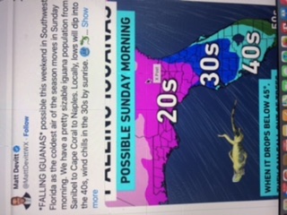
Maybe NWS can create a new advisory for those snowbirds down there.

-
1
-
-
15 minutes ago, snywx said:
15 here right now
14 here currently. Point and click forecast here is for low of 17.
-
1 hour ago, BxEngine said:
2”. Then a heavy .1 or so of freezing rain after fluffy cold snow. What a weird storm.
2.5” here. The low got going too late to throw back additional moisture. The radar this afternoon almost looked like we got dry slotted. Mostly all snow up this way. Currently 23/12
edit: dropped off to 19/9 in the last hour.
-
1
-
-
-
14 minutes ago, Allsnow said:
That’s colder than Mt. Washingtons low temperature.
-
1
-


Interior NW & NE Burbs 2024
in New York City Metro
Posted
9” OTG