

hudsonvalley21
-
Posts
3,870 -
Joined
-
Last visited
Content Type
Profiles
Blogs
Forums
American Weather
Media Demo
Store
Gallery
Posts posted by hudsonvalley21
-
-
2.53” in the Davis. Draining the pool again. No damage or power loss last night. I’m sure there are some not as lucky as me.

-
2.12” as of 11:00 pm
-
A section of Upton’s AFD
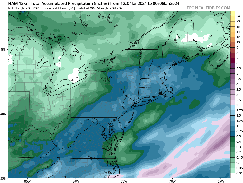
LONG TERM /TUESDAY THROUGH SUNDAY/...
*Key Points*

* A significant storm system will impact the region Tuesday
  night into Wednesday.

* Heavy rain, and river and coastal flooding are increasingly
  likely with this system. See hydrology section below.

* Strong winds with the potential for 45 to 60 mph gusts, highest
  along the coast, Tuesday night into early Wednesday are also
  possible.

A major storm system will impact the area Tuesday night into
Wednesday with heavy rain and both river and coastal flooding.
Models have been in good overall agreement for sometime now in
taking a strengthening low northward across the Midwest and
Great Lakes Tuesday into Tuesday night, sending a strong
frontal system into the region. Deep-layered lift with the
potential for record breaking PWAT values (1.25-1.40"), is
setting the stage for heavy rainfall to overspread the area
Tuesday afternoon and evening. Rainfall rates for about a 6-h
timeframe will be between 0.25 to 0.50 inches, with locally
higher rates possible. This will result in a widespread 2 to 4
inches of rainfall with locally higher amounts. A strong SE flow
will likely enhance orographic lift for areas west of NYC up
into portions of the Lower Hudson Valley and SW CT. NBM
probabilities for greater than 2 inches are near 100 percent
with much of the area greater than 50 percent for exceeding 3
inches. In addition, snowpack across portions of the area may
include up to an inch liquid equivalent. This combined with
saturated soils, high streamflow, and low FFG, points to the
greatest potential of widespread flooding across NE NJ and the
Lower Hudson Valley. WPC also has placed this area under a
Moderate Risk of exceeding flash flood guidance. Many of the
faster responding streams and rivers across this area will
likely go into flood with these forecast rainfall amounts.
Several river forecast points are also forecast to reach
moderate benchmarks. Thus, a Flood Watch is in effect for these
areas. There will likely be refinement and expansion of these
areas in coming days. The heaviest rains will then exit the area
by daybreak Wednesday with some lingering rain possible as the
upper low/trough move through the area.

Another potential hazard will be high winds, especially along
the coasts with SE gusts of 50 to 60 mph possible. A high wind
watch has been issued for LI and may very well need to be expanded
to the CT coast in later forecasts. Elsewhere, Wind Advisory
level winds are possible elsewhere. At this time, used a blend
of the NBM and NBMexp which seemed to best represent the wind
and gust potential based on model soundings.
-
 1
1
-
-
19 minutes ago, MJO812 said:
Nam has 70 mph gusts along the coast. Overdone ?
Interesting. Also the southeasterly winds moving up the Hudson River will be increased with the mountain areas such as West Point. Bridge travels across the river areas could be hazardous.
-
18 minutes ago, jm1220 said:
And yes I would definitely be concerned about major flooding N/W of the city where there was significant snow and now 2"+ rain with roaring southerly winds on Tue, with ground already saturated. That's why honestly it's a blessing in disguise for those of us that didn't get much snow. The SE winds will also upslope in some of those same areas, enhancing the rain amounts.
Had around 9” of snow that has compacted down to 5” so far. What also could cause an issue is the bottom of the snowpack is 2” inches of slush due to some melt and the water not being absorbed into the saturated ground. Low temperature in the teens Monday night will freeze the slush so that will also increase the runoff along with the heavy rain and rising temperatures melting the existing snow.
-
21 minutes ago, CPcantmeasuresnow said:
28.6° in moderate snow.
7.5 inches and I never got into the meat of the deathband and it was still impressive. What a show for those that were in the middle of it.
Same here. Starting to taper off now.
-
3 minutes ago, snywx said:
0z NAM shows 9-11" additional for this area. Interesting. I doubt it but nice to see
The 00z HRRR shows an additional 8”. Maybe another 2”-4” or 3”-5”?
-
1 minute ago, snywx said:
No way he has 9" right now. Maybe half that
Thinking that too. Especially it’s not 10:1 ratios.
-
 1
1
-
-
15 minutes ago, snywx said:
26 w/ heavy snow
2.8” otg
28/28 with heavy snow. 1.5” otg. Super wet snow that compacts to ice immediately when stepped on. Calcium chloride is key for a base.
-
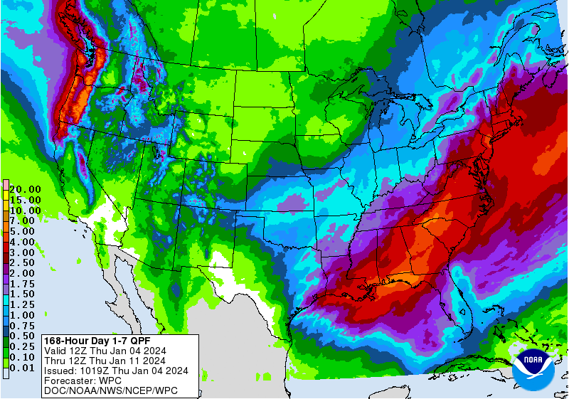
QPF is still concerning for the next week.
-
1
-
-
1 hour ago, Juliancolton said:
I'd really love to see a flake here at some point if it's not too much trouble, no worries if not
It basically just picked up in intensity about 15 minutes ago. Coating on all surfaces. 29/28.
-
1
-
-
29/28 moderate snow now. Coating on all surfaces.
-
2 minutes ago, NJwx85 said:
The totals increased on the GFS in areas that were already seeing all or mostly snow. Nothing has really changed. Locked in now.
It appears that the short range models have also bumped a little north in the 12z runs.
-
1 minute ago, snywx said:
Transfer to the bx or uptown
Most NYPD and FDNY that I know up this way work in the bx
-
1
-
-
3 minutes ago, NJwx85 said:
Almost all rain for NYC on the 12z GFS. Maybe an hour or two of slop.
Also a little more QPF
-
WPC still bullish with the QPF totals for the next 7days.
-
14 minutes ago, IrishRob17 said:
Flurries in the air again today so we should have four days in a row with snowflakes… be still my beating heart
Rest that heart , it will get a workout soon
")
-
1
-
-
6 minutes ago, IrishRob17 said:
So the latest Euro showing 3.5-4.5" of QPF for both storms by next Wednesday...
Hopefully we get enough snow from the 1st event to absorb the rain from the 2nd event to help lower the flooding risk.
-
3
-
-
1 hour ago, IrishRob17 said:
I think we'll see some snow at the start but that storm has cutter written all over it. We'll see what happens though. The 12z GFS got more interesting for this weekend, so we'll see if the other models start getting stronger as well of if it was a fluke GFS run.
Much more interesting the 12z vs. the 06z. Could be that more sampling has been added. We’ll see what the 18z shows.

-
1
-
-
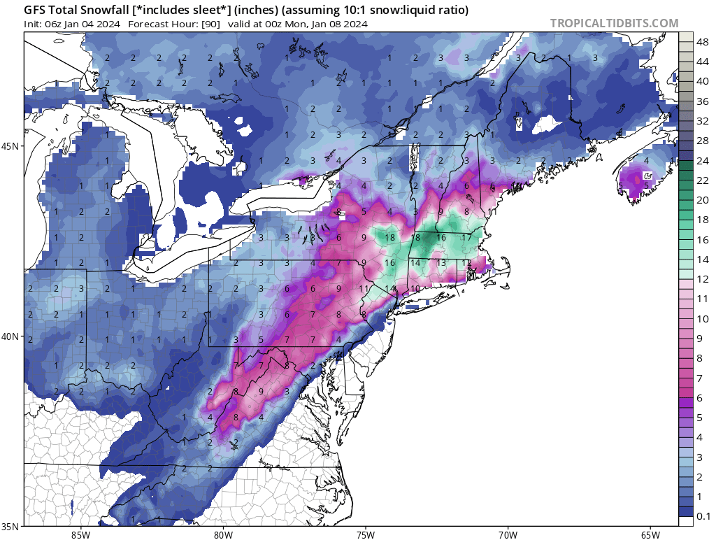
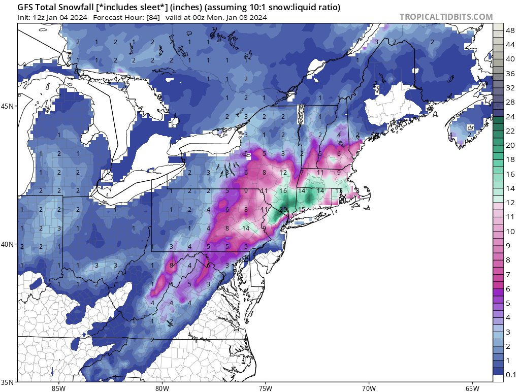
12z NAM has bumped up QPF totals around the NYC area vs. the 06 runs.

-
1 hour ago, the_other_guy said:
Why would they talk about next week when we have a board of experts and enthusiasts that cant really tell us what will happen 2 days from now. We have already established that models are pretty variable outside 72 hours.
Next week may not happen at all. Certainly no way to tell if we have threatening floods until we are 2-3 days out, right? No reason for unwarranted hysteria.
This board would do well with that advice too
We’ll see how it evolves. If it is looking like a major event then they will be mentioning it Saturday night and Sunday during the first event right?
-
9 minutes ago, Big Jims Videos said:
The sad thing about this is the fact tv stations who have not been overly hyping this, rather holding fort with the "stay tuned as the situation unfolds and we learn more information" messaging is lost by the fact that social media is plastered with the snowiest model runs starting last weekend by the fakes. Folks will once again say "where's my snow" without ever even listening to the on air mets, and instead say they were wrong again.
I know they are all focused on the first event and in this thread also. But another issue is the total QPF forecasted for the next week is concerning for the flooding potential from both events. They haven’t really touched base on that on the tv stations.
-
4
-
-
1 hour ago, North and West said:
My new sump pump backup battery arrives tomorrow.
.Good move.

-
1
-
-
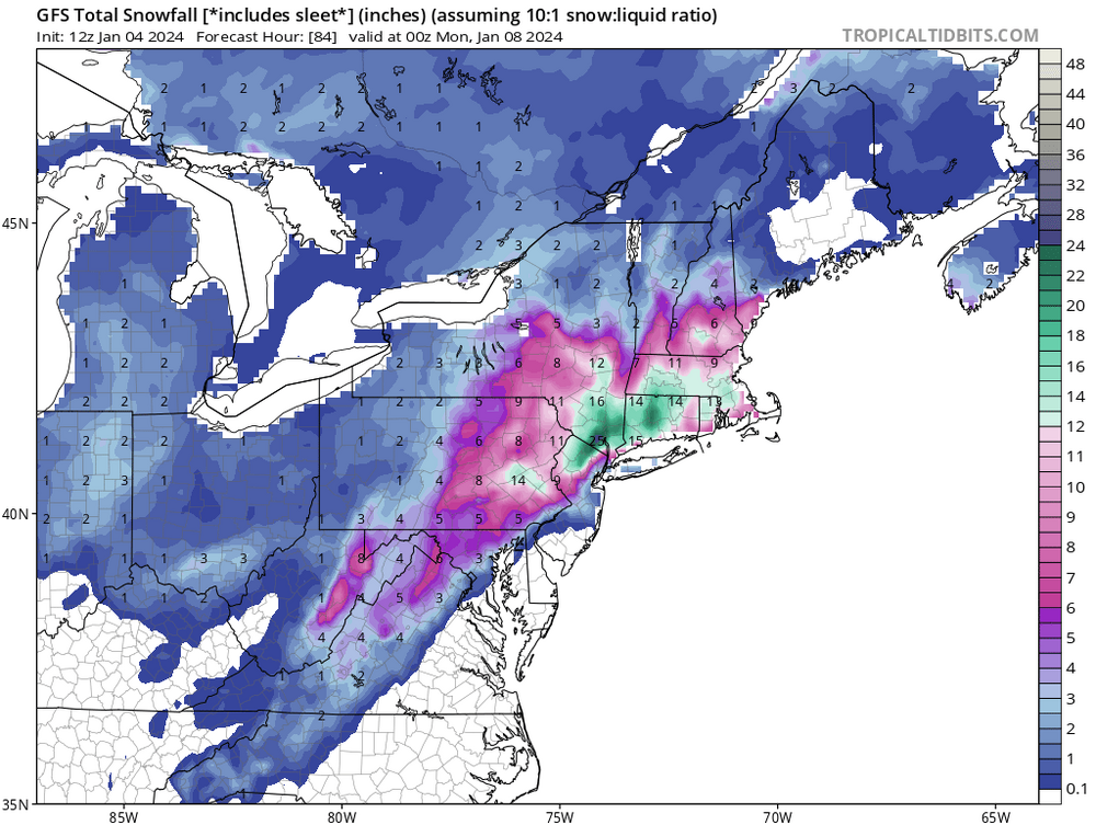
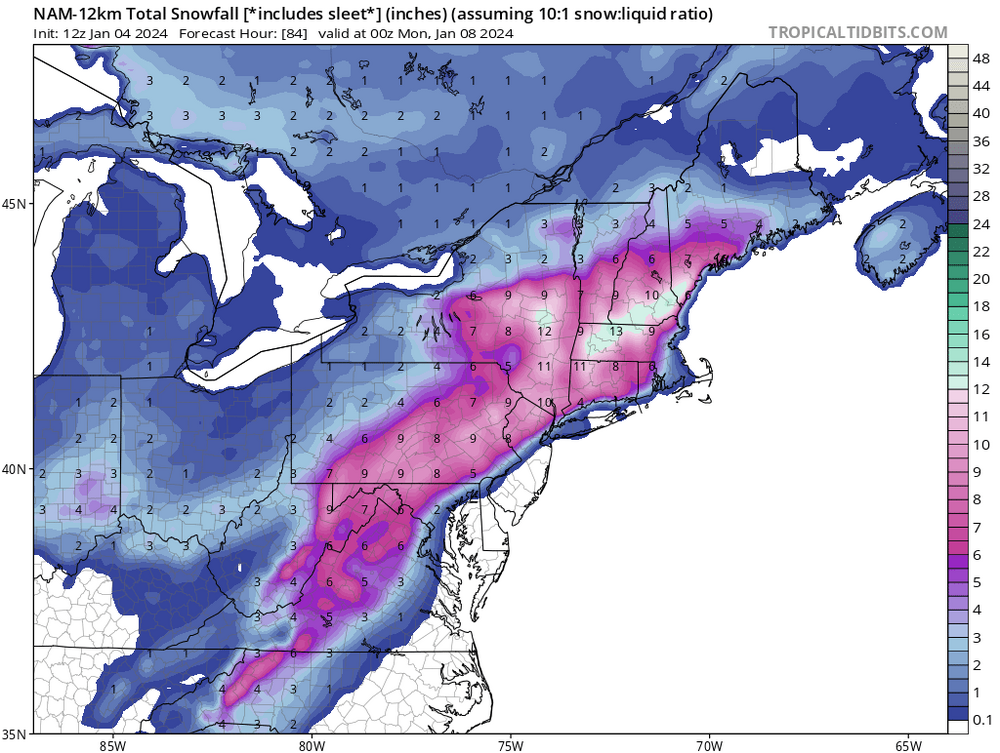
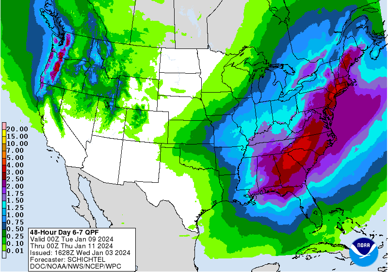
A good amount of QPF for the 2nd event from WPC’s thoughts.


Interior NW & NE Burbs 2024
in New York City Metro
Posted
There is some information and photos of calls on this Facebook account for Orange and Rockland fire.