

DTWXRISK
-
Posts
3,412 -
Joined
-
Last visited
Content Type
Profiles
Blogs
Forums
American Weather
Media Demo
Store
Gallery
Everything posted by DTWXRISK
-
before it turns mild ... there is this ' threat"
.thumb.png.a6ec880eb14cf187988cded946e55398.png)
-
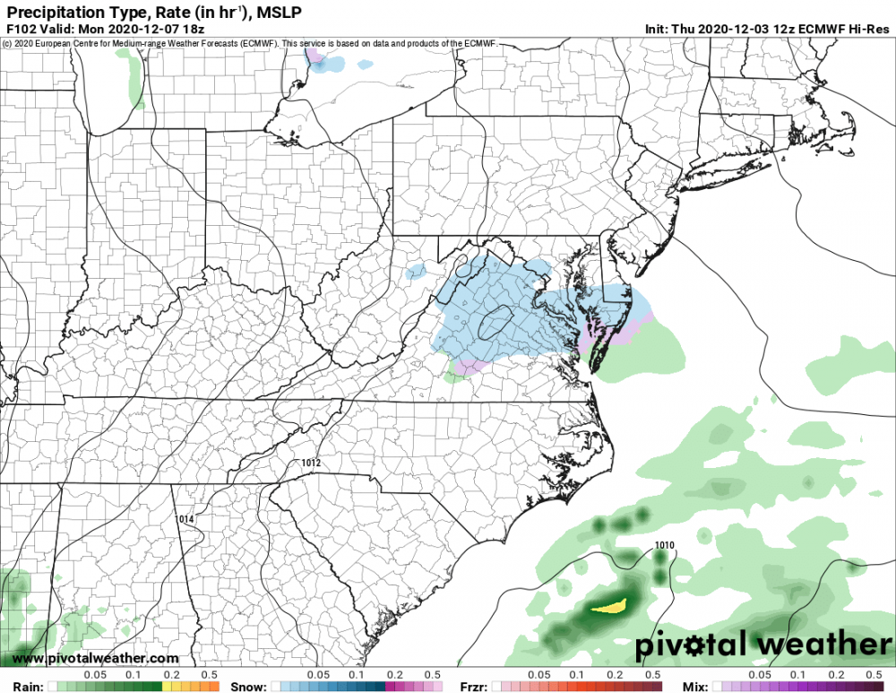
GOOD CHANCE OF 1ST LIGHT SNOW EVENT VA / nw NC/ MD DEL MONDAY DEC 7
DTWXRISK replied to DTWXRISK's topic in Mid Atlantic
consensus kills the overlooked event -
GOOD CHANCE OF 1ST LIGHT SNOW EVENT VA / nw NC/ MD DEL MONDAY DEC 7
DTWXRISK replied to DTWXRISK's topic in Mid Atlantic
it is stunnignto me hwo the GFS does this with every fooking east coast storm -
GOOD CHANCE OF 1ST LIGHT SNOW EVENT VA / nw NC/ MD DEL MONDAY DEC 7
DTWXRISK replied to DTWXRISK's topic in Mid Atlantic
yesterday when I was taking to him about this he thought I was to bullish on this.... -
GOOD CHANCE OF 1ST LIGHT SNOW EVENT VA / nw NC/ MD DEL MONDAY DEC 7
DTWXRISK replied to DTWXRISK's topic in Mid Atlantic
12z EPS IS WETTER with a large precip shield and the event last longer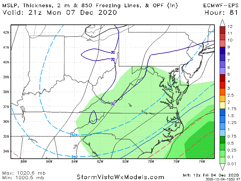
-
12Z eps IS wetter and a longer duration event
-
well technically it was NOT name calling it was DESCRIBING ( joke)
-
yeah but not as funny .... that which does not kill me makes me funnier
-
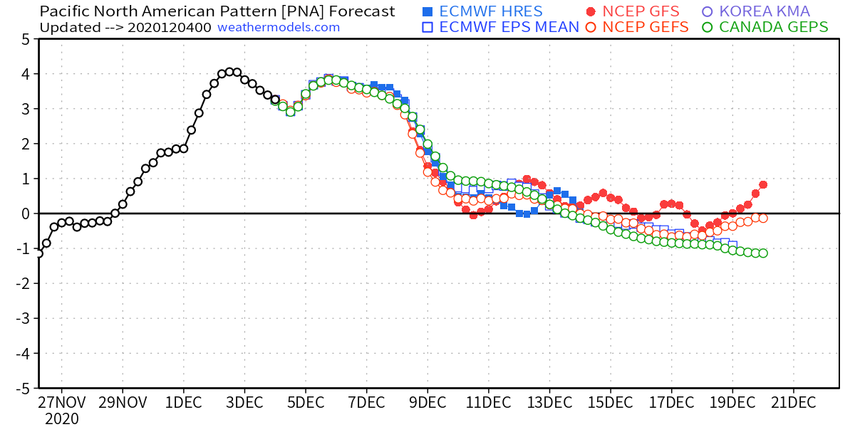
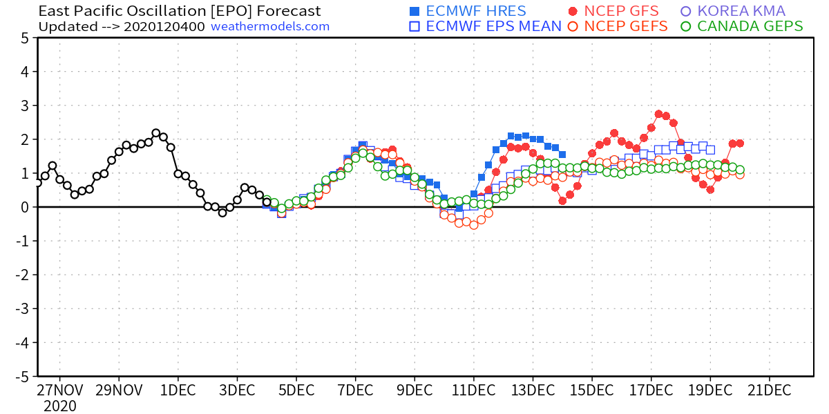
thats because the EPS is vastly different and none of the Teleconnection support this


-
i changed it ....
-
GOOD CHANCE OF 1ST LIGHT SNOW EVENT VA / nw NC/ MD DEL MONDAY DEC 7
DTWXRISK replied to DTWXRISK's topic in Mid Atlantic
good post/ analysis.... FWIW the GFS is mishandling the closed 500 low in Maine/ se Canada -
GOOD CHANCE OF 1ST LIGHT SNOW EVENT VA / nw NC/ MD DEL MONDAY DEC 7
DTWXRISK replied to DTWXRISK's topic in Mid Atlantic
GFS still is BAD with east coast winter storms past like 60 hrs.... and really bad past 72 hrs. Consider the northeast Noreaster about to develops... 3 days the Low was in WVA / far sw VA -
GOOD CHANCE OF 1ST LIGHT SNOW EVENT VA / nw NC/ MD DEL MONDAY DEC 7
DTWXRISK replied to DTWXRISK's topic in Mid Atlantic
why give up? -
GOOD CHANCE OF 1ST LIGHT SNOW EVENT VA / nw NC/ MD DEL MONDAY DEC 7
DTWXRISK replied to DTWXRISK's topic in Mid Atlantic
is that assertion based on anything close to like ya know ...science? -
.thumb.png.d2676c6da630dc0d12cd320b75ad58f2.png)
-
AND W E GOT OUR SELVES A MID ATLANTIC SNOWSWTORM
-
GOOD CHANCE OF 1ST LIGHT SNOW EVENT VA / nw NC/ MD DEL MONDAY DEC 7
DTWXRISK replied to DTWXRISK's topic in Mid Atlantic
TREND IS MY FRIEND -
BLIZZARD? this time of year ssta are too warm ... but if one area could get fookign slammed from a bombing out SE LOW ...its eastern NC
-
as we get closer to the event this dec 7 thing is getting bigger or more significant that is always a GOOD trend ... this threat is one of the threats I talked about on the NOV 29 newsletter
-
dont forget as a general GFS runs often dont handle STJ well
-
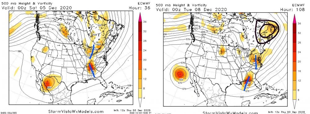
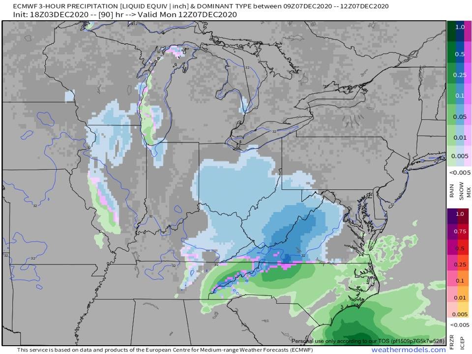
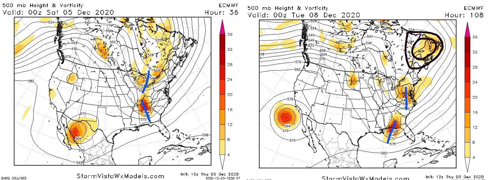
I don't want to make too much of this situation for Monday in this area and I'm not prepared to say that I am barking at this point but the Monday event does have the potential to be a bit of a surprise This image shows two 500 mb maps. The map on the left is the 12z Thursday European model valid at 36 hours or Friday night. The map on the right the upper air map from the same 12z Thursday operational European model VALID evening of DEC 7. IMO what is particularly striking about it is that if you compare the two will notice that the upper air patterns are s almost identical. But of course there are some key differences. Notice that on the Friday night we have no closed 500 low -- known as the 50/ 50 LOW in southeast Canada but we will have one according to the European model Monday night. Also note that on Friday night we have two short waves -one in the Northern Jet Stream over Michigan and the southern one in Tennessee and Georgia which is about to go negative. And that of course is going to trigger the coastal LOW and its rapid intensification. On Monday night DEC 7 we have a southern stream s/w which is further to the south which is still tilted slightly positive. The northern shortwave is closed off and this is located in Virginia and Pennsylvania. The end result is that because we have the closed 500 low in southeast Canada these two short waves are going to phase further to the South and east ….which means that the coastal LOW is going to form further to the South and probably off the coast. This is a timing problem. If the southern s/w were to come in more neutral or negatively tilted over Georgia then you would end up with a much stronger Coastal LOW and the potential for a surprise snowstorm in portions of Virginia and Maryland on Monday December 7. These two images show only light snow Monday morning in much of Virginia and temperatures are clearly cold enough. The 18z Euro is somewhat more aggressive with this burst of snow and this is supported by the 18z EPS. I think we will have to wait until after the Saturday system is gone before we will have a really good idea about what if anything is going to happen in the lower Middle Atlantic states on December 7th. Right now I think there is pretty good chance for light snow event lasting most of the morning / midday for a good portion of the Dominion and perhaps portions of Southern Maryland and Delaware. Maybe it will ll just be snow showers. Maybe it will end up being something a little more
.thumb.png.372b668b154a552f9efbc772ff42391c.png)

-
I don't want to make too much of this situation for Monday in this area and I'm not prepared to say that I am barking at this point but the Monday event does have the potential to be a bit of a surprise This image shows two 500 mb maps. The map on the left is the 12z Thursday European model valid at 36 hours or Friday night. The map on the right the upper air map from the same 12z Thursday operational European model VALID evening of DEC 7. IMO what is particularly striking about it is that if you compare the two will notice that the upper air patterns are s almost identical. But of course there are some key differences. Notice that on the Friday night we have no closed 500 low -- known as the 50/ 50 LOW in southeast Canada but we will have one according to the European model Monday night. Also note that on Friday night we have two short waves -one in the Northern Jet Stream over Michigan and the southern one in Tennessee and Georgia which is about to go negative. And that of course is going to trigger the coastal LOW and its rapid intensification. On Monday night DEC 7 we have a southern stream s/w which is further to the south which is still tilted slightly positive. The northern shortwave is closed off and this is located in Virginia and Pennsylvania. The end result is that because we have the closed 500 low in southeast Canada these two short waves are going to phase further to the South and east ….which means that the coastal LOW is going to form further to the South and probably off the coast. This is a timing problem. If the southern s/w were to come in more neutral or negatively tilted over Georgia then you would end up with a much stronger Coastal LOW and the potential for a surprise snowstorm in portions of Virginia and Maryland on Monday December 7. These two images show only light snow Monday morning in much of Virginia and temperatures are clearly cold enough. The 18z Euro is somewhat more aggressive with this burst of snow and this is supported by the 18z EPS. I think we will have to wait until after the Saturday system is gone before we will have a really good idea about what if anything is going to happen in the lower Middle Atlantic states on December 7th. Right now I think there is pretty good chance for light snow event lasting most of the morning / midday for a good portion of the Dominion and perhaps portions of Southern Maryland and Delaware. Maybe it will ll just be snow showers. Maybe it will end up being something a little more

.thumb.png.a9f599236ac113999db5a9f592fdf04b.png)

- 346 replies
-
- 10
-

-

-
December 2020 General Discussions & Observations Thread
DTWXRISK replied to bluewave's topic in New York City Metro
simon lee ...good met -
December 2020 General Discussions & Observations Thread
DTWXRISK replied to bluewave's topic in New York City Metro
-
.png.18ff57c602a223b6913684f62c156dd1.png)


.png.56aa8d7d9916f47fbac28d55dce53cbb.png)
.png.6cb60ac3ff4574f427ead380e86ba309.png)


.png.8a58dc245f43c8f09ac40c4d6d57ddf1.png)
