

FallsLake
-
Posts
6,317 -
Joined
-
Last visited
Content Type
Profiles
Blogs
Forums
American Weather
Media Demo
Store
Gallery
Posts posted by FallsLake
-
-
Rah still on board for a weekend cool down, but they are leaning towards the euro for the details.
<last two paragraphs of the extended discussion>
Thursday night into Friday the upper level low will rotate east towards Quebec with another shortwave diving southeast out of Ontario on the backside. The GFS is slightly more amplified with this secondary wave compared to the ECMWF, while the CMC wraps this secondary energy up and actually holds it back a bit. The GFS solution pushes a cold front into central North Carlina Friday afternoon and has the front clearing North Carolina Saturday. The ECMWF and CMC are not this optimistic. The ECMWF stalls the front over central North Carolina while the CMC washes the front out near the Coastal Plain. Looking at the GEFS also reveals that the deterministic run is optimistic compared to the GEFS mean regarding drying conditions. The overall trend for the forecast was towards the ECMWF/ CMC and GEFS mean. This means widespread coverage is likely starting late Friday evening into Saturday as a cold front oozes south through the area. PWATs ahead of the front are forecast to be around 2.1", or near max values for this time of year. Warm cloud depths are also forecast to be above 12.5 kft at times which will help to maximize warm rain processes. Saturday afternoon the ECMWF, EPS mean, CMC,and GEPS mean show continued widespread coverage. The GFS at this time is dry having the front down towards South Carolina. As mentioned above, have kept towards the CMC and ECMWF here and raised PoPs for Saturday. The other trend for Friday and Saturday has been to nudge temperatures down. Given widespread convection forecast and a cold front oozing south think temperatures will be below normal for this time of year. Sunday the CMC and ECMWF show continued widespread coverage as the front stall across southern North Carolina and multiple mid-level impulses ride east along the baroclinic zone. Temperatures Sunday into Monday will likely remain below normal with a potential weak CAD developing.
-
10 minutes ago, yotaman said:
That would be awesome so I highly doubt it would happen. Even with the rain this past Saturday we never got below the mid 70's.
Yep, the 12z GFS still shows the cool down but not as pronounced. RAH said the euro was also not as enthused.
-
Usually September sees the first big breaks in the heat. Many of us can open our windows and enjoy the cooler temps. But that doesn't happen all the time. Just look one year back and see how the heat can hang around longer then normal:
Lets hope for a different September this year...
-
7 minutes ago, Iceagewhereartthou said:
Well this weekend the upstate should see highs in the low 80s or even high 70s with clouds and some rain, but even after that the highs are all 80s; so no 90s. That's right on cue for our first fall "cool down" coming in late August. This past 10 days or so have gotten old quick!
This time of year is comparable to late February; whereas usually the heat/cold starts to get toned down, but the full force of the season can still present itself all the way into the first week of the following month.
-
I'm liking what the 6z GFS is showing in the LR. One nice cool down for this weekend and then another at the end of its run. **RAH states the euro doesn't agree
6z GFS for this midday Saturday (it would be drizzly, but would feel like Fall):

-
 2
2
-
-
ESNO-neutral is forecasted through winter this year:
https://www.cpc.ncep.noaa.gov/products/analysis_monitoring/enso_advisory/ensodisc.shtml
What could this mean (from Ian Cassette, Roanoke VA):
https://www.cpc.ncep.noaa.gov/products/analysis_monitoring/enso_advisory/ensodisc.shtml
-
3 hours ago, SN_Lover said:
Really neat! Do you mind sharing those python scripts?
I'll talk to our developer on Monday. I actually have an older Python Toolbox script that converts the rss feeds to a File Geodatabase and then published the data. But that has to be run manually to create one copy of the data at that particular time. I'll also send that to you.
-
1 hour ago, SN_Lover said:
You will only be able to display real-time data with arcgis geoevent licence which uses the spatial temporal big data store.
Yeah, when we start linking to the Here data (and other real-time data) we'll have to be in the cloud. Our IT Infrastructure folks are already talking about moving in that direction. NCDOT has some live data (TIMS - current road incidents) which is served out as Georss feeds. We (NCDIT) have Python scripts that convert the data every 3 minutes into SDE/SQL server, which is referenced to a published service. **This is not exactly live but close.
Here's our AGOL page:
http://ncdot.maps.arcgis.com/home/index.html
-
5 hours ago, SN_Lover said:
Are you using geoevent server? Should not be hard to get radar.
Just the services here for weather:
https://www.weather.gov/gis/WebServices
We are an Esri shop and display our services through ArcGIS Online. Dealing with the GeoEvent server, we are not (yet) using that cloud platform. (right now)We manage our own data on our own internal servers. We are looking into linking to real time data working through "Here" (..for congestion data). But again we're managing the backend data (our servers, not cloud (..yet)).
-
Got over 2" from the later afternoon storms. Started raining and it wouldn't stop.
-
1
-
-
Thanks Solak! My group is charge in organizing/providing GIS services and radar is one of the map services. Hopefully we can (directly) access any new outputs. **sometimes GIS services are only accessible through the website viewer.
-
12 hours ago, Upstate Tiger said:
Yes but with so much of the country AN to our north and west, it won’t make much difference for us unfortunately. Not a big deal really. We really don’t start seeing any relief in the SE until after mid month anyway
From all my years of memory, we usually (on average) get our first real Fall cool down after the first week of September. Of course sometimes we get a cool down as early as late August, but normally the heat of summer continues for at least all of August.
At this point, we want to start looking northwards into SW Canada. In the next couple of weeks we should start to see this area cool down. We could even see the first signs of mountain snows in Montana (Glacier, maybe even Yellowstone areas). It doesn't immediately help us but eventually that cool air will build and spread southwards.
-
2
-
-
1 hour ago, WinstonSalemArlington said:
While it’s not quite time to turn on the heat, there is no noteworthy heat in site. Mild to meh warmth ahead.
That's about as much as we can hope for this time of year. Looking at the LR GFS, it looks to continue pushing fronts/troughs towards the east coast. Hopefully the fronts will get through our area. Also, this should help steer tropical storms away from us.
-
One great thing about our area, we can get the big storm. We fall short more than we win, but ever so often...…...
-
1
-
-
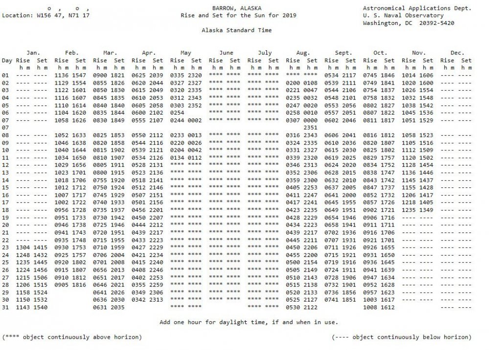
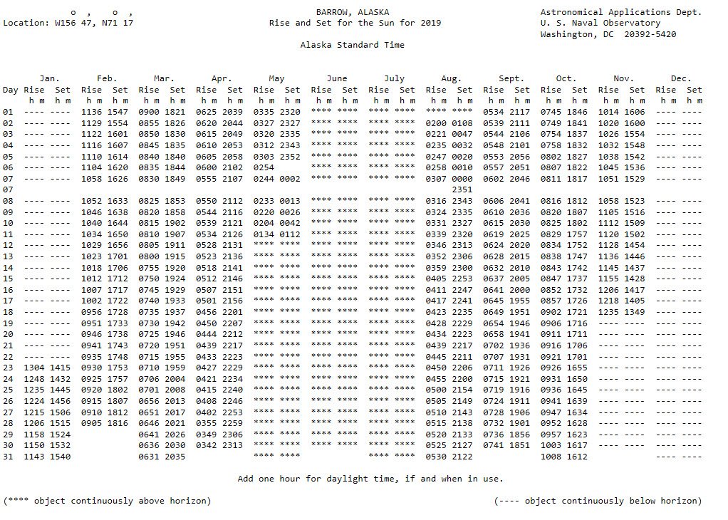
Here's something small to celebrate; the sun sets at Barrow Alaska tonight (first time since spring).
-
On 7/31/2019 at 10:06 AM, frazdaddy said:
Good read ,thanks' Falls. I remember that and Fischell talking about it.
Yeah even though it's very rare, it's something we can hope to see again in the future.
-
47 minutes ago, NorthHillsWx said:
The "Old" GFS has it too, albeit closer to the coast. I work for Duke Energy and am part of the storm response team so, trust me, I hope everything recurves this year! It's been a whirlwind for us last few years between Matthew, Nate, Irma, Florence, and Michael! I do enjoy tracking these storms, especially Cape Verde ones. I hope it's a busy season but only with fish storms!
I hear you. I work for NCDIT GIS (formally part of NCDOT). We're tasked with developing, gathering, and serving out transportation related datasets during emergency events. It was absolutely horrible last year. I think I went three weeks without a full day off.
-
3 hours ago, shaggy said:
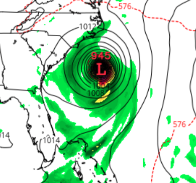
Yeah it is on a classic track in the models but turns north sharply along the Bahamas.
I'm hoping all storms turn away this year. My group was overwhelmed last year during/after the hurricanes. I want nothing to do with these storms again.
But the 12z GFS still shows the storm. It still recurves, but we all know that can change if the high to the east is closer or stronger.
Day 10:

-
2 hours ago, Typhoon Tip said:
Firstly, I'm not sure the social-media community in this particular web destination really IS of the 'wanting/wishing' ilk
") ... I'll just expand on that a little more... but it was really a 'just in caser'
... I'll just expand on that a little more... but it was really a 'just in caser'
Imho, should 2019 somehow by excruciating number crunching ( less than obviously ) fall short of 2012 ... was it really worth all the effort and writing...and annotated graphs and monitoring and ..well, basically obsession?
We are not "making sure that happens" - by plying that effort. I can understand statistical accuracy but I wonder if the real motivation for doing so lurks behind that excuse, because the bigger, longer term consequence of what the world faces is so dire right now that to do so ...could not be any more futile. If it falls short, nothing's different. Why then? The longer vision, we're still f*!&ed folks.
As far as that article... There's a lot of complexity that is not really discussed in that... In a general scope and concept it's not "un-clad" exactly ...But, there are ... synergistic effects that are 'emergent properties' and aren't really predictable... More over, those can have secondary ...tertiary spontaneities too...
The blocking idea can come from other sources:
First, ... extinguishing planetary wave/dispersion into higher altitudes. Think of it as where warm advection plumes go to die. The vagaries of R-wave undulations over time, can create episodes where/when warm fluxes cause/contribute to tropospheric blocking .. These are ephemeral in nature... If they persist ( causally ) it's the underpinning pattern that's supporting it.. The NAO domain is a good teleconnector to exemplify this.. It can fluctuate at intraweekly time scales because of this sort of transient phenomenon... And is why seasonal predictions for that teleconnector - heh... good luck.
Second ... blocking anywhere from that can happen in any era.
Third, ... it is not abundantly clear that GW would in fact promote more of that to happen, because ... it's all still based upon gradients. Without gradients...no air movement exists at all. From that very fundamental requirement of physics, working together with gravity over a curved surface... without the first initial requirement of changing PV=NRT from one point to another...not of this, in fact, this conversation, can happen.... Why is that important? Beyond the obvious ... the arctic also is said to be differentiating warmer/faster than everywhere else... Is that true in the middle troposphere? If so... than the gradient is not necessary increasing because of GW... but, I suspect it is anyway... The arctic is just trying to catch up ...and in the interim ...we are witnessing extraordinary jet speed anomalies and have been now over the recent decades. Flights between NY and London...also across the expanse of the Pacific have registered historically fast ground-based velocity speeds in that time. This is happening because the warmer equator/sub-tropical latitudes are storing more water vapor ( concomitant with the GW ...) and fiddling with the math ... that is keeping heights slightly elevated; pressing ( as it were) against seasonal nadirs in the winter. Even if they are warming...they are not warming fast enough to compensate for the ambient steepening of that gradient that exists between ~ 35N and the 60 N girdle around the hemisphere. This creates the hurried velocity saturation being observed...
Lastly ... folks are forgetting that we are still moving through the 11, 22 and 300 year temporal super-position of the Max(min) solar. Those times have been correlated strongly with -AO tendencies... That makes it incredible difficult to untangle 'how much' of blocking is a result of warming arctic ( as it relates to GW ) - vs how much was destined to take place as this solar expectation has arrived and we transpire through... I suspect like everything...there's shared forcing there...
** The gulf stream stuff and the AMOC - that's a whole 'nother ball of wax. The warming in the previous ... probably going back to the early 1980s is when it really started... has been adding fresh water to the surface of the Atlantic... That's been accelerating particularly in the latter half of that multi-decadal time span. At some critical threshold the specific gravity has changed too much...and the buoyancy gained in the acquiesce saline waters (at a given temperature).. slows and/or can stops the sinking water process... No sink = no drawing surface water N = break down of the Gulf Stream. This was theorized back then, too... We are ( more likely so ) now seeing this being measured in the environment...
Altering the transport of warm surface waters to higher latitudes certainly would effect circulation tendencies through the various meteorological circuitry over time...and time being a variable in climate - there we go...
It's a mind boggling array of countermanding forces and whatever is left after canceling out ...dictates the systemic character.
Thanks for the great response!! I'm actually coping this post for future reference.
Your probably right about the underlying reason for the article. And we very well could be f*!&ed.
But (if we want to very selfish and shortsighted), if the arctic is going to hell we might as well score some good winter storms.
-
16 minutes ago, Typhoon Tip said:
It seems there's an underpinning 'agenda' to keep this year elevated above 2012 ... I guess for the sake of records? I'm curious because I'm not sure why we are so preoccupied by finite distinctions and what those mean to specific records, when the specter of what's happening over the last 20 years is far more telling. I would certainly hope that no one is coveting or even abstractly taking comfort in a acre less melt if it comes to that...
In any case, last week I mentioned that the heat wave in western Europe was modeled to plausibly affect Greenland and now ..headlines to that effect are indeed foisted. Granted CNN,
https://www.cnn.com/2019/07/31/europe/greenland-heatwave-climate-crisis-intl/index.html ,
... tends to spin toward aggrandizing in any attempt toward ratings that turn the gears of their media-profit-machine ... we'll just have to see if corroboration surfaces ... I believe some acceleration is likely though.
The deep tropospheric heat anomaly effectively severed, formulated a high latitude blocking node ...and that feature has since been retrograding toward Greenland. Still carrying along with it actual warm thicknesses within the anomalously tall H500 isohypsotic surfaces - in other words...a balloon of warm rich ice-sheet melting air - I was wondering if this may enhance the seasonal melt rate. Seems to be at least according to CNN's dystopian formula -
The question is, if so ... does any of this also effect an acceleration of ice loss in the total arctic?
I'm definitely with you on truly wanting/wishing that the ice lose would reverse course; which it looks like it will not anytime soon.
But saying that, what do you think of the concept that as the Arctic warms, lower latitudes could cool (especially in winter).
https://news.nationalgeographic.com/2017/07/global-warming-arctic-colder-winters-climate-change-spd/
** I suppose this could also go along with the idea that the Gulf stream could slow or stop...
-
Here's a good discussion (..at the end it turns to a debate) on lake effect snows for central and eastern NC. There are some good example links for 2003 and 2009.
As a side note: While living in Wake Forest back in the 90s, we had a similar event whereas a cold front passed and a nearly stationary thin band of snow formed over northern Wake County. Ended up with ~1" of snow (nothing was forecasted).
-
36 minutes ago, shaggy said:
We went to the beach yesterday and the water had gotten downright chilly. Water temp at jennette's pier in nags head had dropped down to 64 degrees on the northeast winds and upwelling.
Same thing happened to me last week while in Kitty Hawk. Before the front came through, surface temps were in the 90s but the water temp dropped to 61 degrees. After the front came through, surface temps fell into the low 80s but then the water temp came up to tolerable levels. Crazy...
-
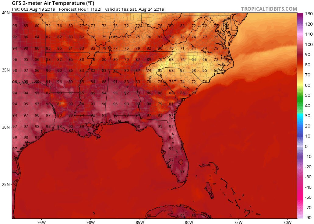
Currently at Kitty Hawk on vacation. Light rain and temps in the 60s. Wind makes it feel cooler. Next few days will be great beach weather with temps in the low 80s.
-
 1
1
-
-
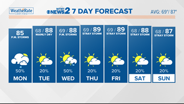
Got to the Outer Banks yesterday and man it's as hot here as the inland areas. Mid 90s yesterday and a repeat today. I'm guessing it's in the low 80s this morning. Waiting for the cool down on Tuesday.
Banter Thread
in Southeastern States
Posted
I've heard this winter we're going to get storm after storm that follows this path: