

FallsLake
-
Posts
6,317 -
Joined
-
Last visited
Content Type
Profiles
Blogs
Forums
American Weather
Media Demo
Store
Gallery
Posts posted by FallsLake
-
-
I keep thinking this is another GFS amped system (similar to the last event). I suppose it good the other models show the storm (..much weaker). As others have said, the euro is close.
RAH:
The forecast for next weekend remains uncertain as there have been inconsistencies from run to run of the ECMWF and GFS as well as their respective ensemble counterparts. GFS and GEFS solutions have been depicting a very deep upper trough and associated surface low moving through the Southeast. EC and ECENS have maintained a similar idea but much less intense. Today`s 00Z ECMWF is depicting an even weaker upper trough than before, but does continue the idea of weak coastal cyclogenesis off the South Carolina coast. This solution would bring some rain to the area Saturday and Sunday but nothing significant. NBM PoPs during this period are near climo and until a more clear consensus can be reached, sticking with its low impact forecast for next weekend with slight chances of rain and above freezing temperatures seems like the best approach.
-
 2
2
-
-
Of course I'll always wish for wintery precip over any other weather feature, but I would love to see an old fashion Siberian Express arctic airmass. We had the one a couple of years back but nothing really substantial last year. I love sunny days below freezing and seeing the lake freeze over.
-
3
-
-
Not sure about this one. I'll put my hopes on it, but not my money. It's going to take a perfect setup and strength of the low. One nice thing, if it strengthens as the GFS depicts (especially from 0z last night) there would be a good source of cold air to get pulled in. But that's the key, get pulled in; again we'll need this low to be perfectly placed (to our SE) and strong (..bombing off the coast).
-
1
-
-
29 minutes ago, Solak said:
RAH thoughts at this time...
Cyclogenesis will then occur from the GOM to the Sern and
middle Atlantic coast later Fri into the weekend. While
precipitation chances will consequently increase, the preceding
Arctic high will have retreated by that time, given an unfavorably
configured mid-upr flow pattern for maintaining a cold high for
wintry precipitation in cntl NC. As such, any p-type concerns would
be brief and limited to onset over the nw Piedmont early Fri, if at
all.

It should be noted that the 06Z and 12Z deterministic GFS solutions
that depict a much stronger, lead srn stream perturbation --and
cyclogenesis off the sern US coast centered around Thu-Thu night--
has little deterministic or ensemble support and is consequently
considered an outlier/low probability solution at this time. Such a
solution, however, would be an icy one owing to the maximized
presence of Arctic high pressure that will otherwise be in place
during that time.
Yeah Solak, I read this two different ways. One RAH is telling us the GFS is an outlier (for good reasons); but two they're thinking it could happen. (so)Low odds but they need to cover their butts. We need to hope they keep mentioning the possibility in tonight's discussion,
I will say I have grown to really respect the mets at RAH over the years.
-
2
-
-
1 hour ago, ILMRoss said:
Not to be a buzzkill but I have been around this forum long enough to play the “maybe the Baja shortwave will change and work in our favor this model suite” game. It doesn’t work out a lot. Seems like we’re going to be stuck in this cold/active pattern for a while; my advice is to take the energy focused on this storm and instead direct that energy in completing your holiday shopping this weekend, so that you can track models and speculate on forums stress-free by the end of December

Great advice! Right now there's nothing to specifically focus on except (as you said) for the overall pattern configuration. We need to get one of these (10/12 day) fantasy storms to within 6/7 days, and then have support from other models before we truly bit on a potential storm.
It might be frustrating to see these storms pop up and then disappear, but it is a function of being in a cold/active pattern; whereas the models will spit out potential winter storms because the pattern does support the potential.
-
3
-
-
Man, the CFS says we could be in for a wild ride the next few weeks.
Start from beginning and go to the end. Lots of potential storms (especially for central NC northward).
-
1 hour ago, Fantom X said:
Having been here in the SE for a year now, and used to a good amount of snow over the past decade, I have had to make my piece that I will never see snowfall total's like this again (except 2011-2012)
YEAR YEAR Oct Nov Dec Jan Feb Mar Apr Total 2009 2010 0 0 26.3 12.7 28.4 0.4 0 67.8 2010 2011 0 0 19.8 35.7 4.7 1.3 0 61.5 2011 2012 0 0 0 5.5 0 0 0 5.5 2012 2013 0 1.1 1.4 4.7 35.8 8.8 0 51.8 2013 2014 0 0.2 5.4 24.8 23.9 3.2 0 57.5 2014 2015 0 0 0.3 22.8 15.2 23.9 0 62.2 2015 2016 0 0 Trace 18.8 14.3 2.7 0.1 35.9 2016 2017 0 0 4.1 14.3 15.8 7.9 0 42.1 2017 2018 0 0 7.4 21.2 1.3 21 4.3 55.2 If you look at our odds of a big year for each individual year, it's low. But we do live in a region where big snows can happen. So even though I would say don't expect much, you can hope/dream that we get one of those rare years.
https://www.webberweather.com/about.html
-
 1
1
-
-
1 hour ago, Tacoma said:
Well from whats happened in the past I wouldn't want a big snowstorm in December because I swear every time we have a big snowstorm in December I think we're going to have a great winter and then the rest of the winter we end up without another nice storm at all. So I'll take my chances with the big snows holding off until January so maybe we can get a couple of nice storms.

I understand your reasoning, but I've learned over the years get what you can, any time of the year (..we're the SE). We could have a warm December and then keep getting warmth straight through spring.
-
2 hours ago, mackerel_sky said:
Based on models! I don’t see any cold snaps, I mean I get down to 28 one day out of the next 15 . I mean if you’re here to track normal temps and occasional rains , by all means, go for it!
Yeah Mack, I don't see any big pushes of arctic air the next couple of weeks. No torches, but as you stated very normal (continental air masses). I wouldn't mind seeing an arctic front (Siberian Express) come trough; even if it just produced a dry outcome. Seems like it's been sometime since we've seen this in December.
-
1
-
-
Cold rainy day (again). Temp has stayed in the 40s all day and to this point received .46" of rain. I guess I can't complain, at least we're not getting a torch pattern.
-
Ended up with .23". Better than expected.
-
1 hour ago, calculus1 said:
Bit of an over-performer today in the rainmaker department. Yesterday, my P&C forecast was for less than a tenth of an inch. This morning, the P&C said between a tenth and a quarter of an inch. As of 9:20 AM, I sit at 0.53 inch in the rain gauge. Maybe a sign of things to come for winter? Regular over-performers? One can hope...
Same thing over this way. Sitting at .18" and it's still coming down. Might end up with ~.25" before the line comes through. Wasn't supposed to get anything but a light shower or two.
-
Funny/interesting what RAH said in their Short Term discussion last night:
.SHORT TERM /THURSDAY AND THURSDAY NIGHT/... As of 215 AM Wednesday... 1035+ mb surface high pressure is expected to build across the eastern states from Ontario and the Great Lakes states Thursday and Thursday night. CAA will send the temperatures below normal for Thursday and Thursday night. Expect highs 5-10 degrees below normal with highs most likely skewed toward the colder MET/EC statistical guidance. The GFS appears too warm. Expect mostly mid to upper 50s north and lower 60s south with mostly sunny skies. Expect mainly clear and cold conditions Thursday night with lows in the upper 20s to mid 30s. Throw out the GFS MOS! It is too warm, again. &&
-
1
-
-
^^Yeah not sure how everything's going to evolve. For Thanksgiving day, the GFS and euro would have below normal temps over a good portion of the SE; owing mainly to a CAD. The Canadian doesn't see this and is showing 60s/70s.
-
2 hours ago, FLweather said:
12z and 18z nam show very brief zr chances with Friday/Saturday system. Mainly north and along I85/I77. Upstate SC and NC.
Before temps rise to the lovely 33-34 cold rain.
We're really good at getting 33 and rain. But honestly, for this time of year a cool rainy forecast is fine.
-
3
-
-
17 minutes ago, jjwxman said:
This is definitely intriguing. Particularly since the global models tend to underestimate the CAD at times. This has the makings of a sneaky little system.
As always, it will be close. I think many of us will just get a very cold rain; which if you think about it fits well with the time of year (Thanksgiving --> cool, overcast, rainy).
But who knows....
-
1
-
-
7 minutes ago, HKY_WX said:
Looks like LES off of Kerr lake
RAN stated the possibility this morning. Fascinating that can occur in our part of the world with the smaller water bodies.
-
Ended up with a nice rain event (the liquid over performed..). As of 2:51 RDU received .93".
-
Getting a little sleet mix here at the office (US1/US401) for the past 15 minutes.
-
Wife said it was sleeting in east Durham County near Wake County boarder about ten minutes ago. It's a race...
-
Many of us are hoping to see a few snow flakes (including me), but I'm also happy with the rain showing up on radar. Be nice to get a 1" of rain and then a few flakes...
-
As Mr ROSS stated above, any snow flakes in November is a win. From RAH:
Non-liquid precip chances: As models converge on an agreed-upon common timing of precip and vertical thermal structure, confidence is fairly high that the northern Piedmont and northern Coastal Plain (roughly along and N of Hwy 64) will see some wet flakes and/or sleet pellets mixing in with the rain on the back edge of the precip. But based on how the strongest and deepest lift (including fgen and that aforementioned strengthening upper divergence) is lining up vertically and temporally with the arrival of the cold air and within the DGZ, I have some concerns that we`ll see a short period of sufficiently high precip rates to switch us over to mostly snow and sleet for a brief time, although likely no more than an hour. While the ground should be warm enough to prevent accumulation there (NC State Climate Office agnet stations confirm this), heavy enough rates may produce a light coating on elevated surfaces. Confidence in this scenario is not high enough to warrant any mention of accumulation at this time. But this is certainly something to be watched closely this morning.
-
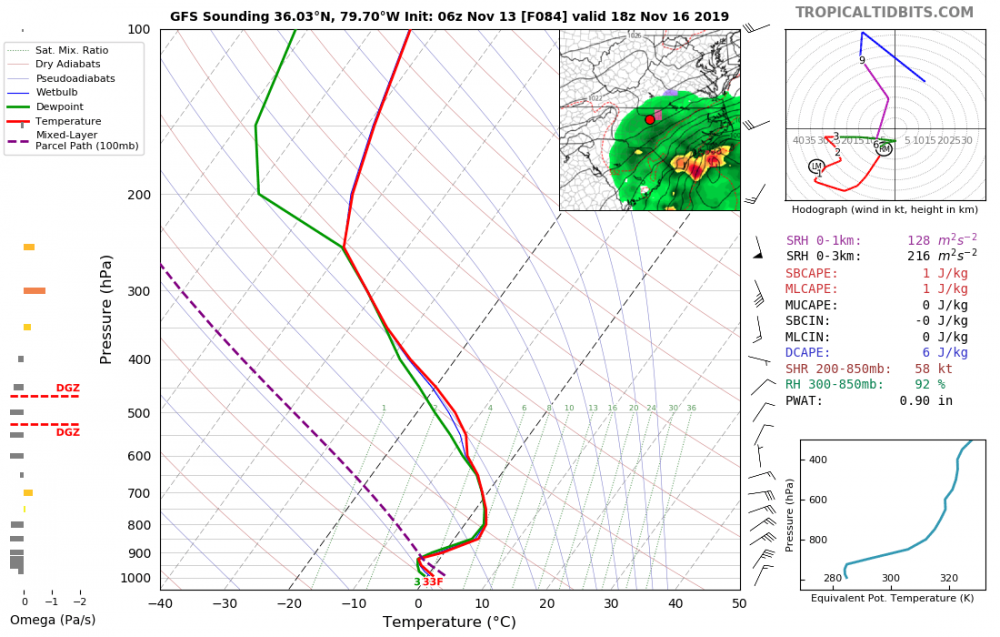
The 6z GFS continues to show the potential wintery event. I think it's possible, but (of course) there are many factors not in the favor of a good winter storm. One key thing to tract in the coming days (if we're tracking), is how fast we can get the lower dew points to push into the CAD regions. Right now, I don't think it's enough. Dew points in the teens get into N VA but only get down into the upper 20s (at best) down into N NC. My thoughts, if this was to materialize as shown on the GFS we would probably get some mixed snow/sleet with the rain. And then if it did switch over it would really have a hard time accumulating. **it would be a typical (rare) November winter event outside the mountains.
-
59 minutes ago, yotaman said:
That would be pretty epic for November so I doubt it will verify.
It will probably get cold. Add 10 degrees to the 18z GFS and we'd still be talking record temps. I would think 40s highs with lows in the 20s would be a great guess at this point. **folks have been talking about the GFS cold bias in the LR.

December Observations
in Southeastern States
Posted
Cold morning at my location. 23 degrees. Nice to still get some cold mornings while we wait (….how long???) for a good cold pattern.