

FallsLake
-
Posts
6,317 -
Joined
-
Last visited
Content Type
Profiles
Blogs
Forums
American Weather
Media Demo
Store
Gallery
Posts posted by FallsLake
-
-
Just now, HKY_WX said:
Def think some supercell tornadoes are possible along I40 this evening. Sunshine breaking out today has made things volatile in the Piedmont of NC.
Just hoping they hold off until after 8pm. WRAL is concerned about pop-up storms before the main band.
-
Just now, Solak said:
84 with HI of 89. Halloween candy is melting!!!
Yeah, it feels like when I was a kid living in Florida. But we didn't care. We still went for the candy.
-
1 hour ago, NorthHillsWx said:
Currently 65 degrees with Light Rain. Actually have over-performed here as we're sitting at .50" already with rain continuing. Heavy mist has actually been fairly efficient in accumulating. Saw the airport has less than half as much. Had some moderate rain for about 2 hours with a patch that developed right over here. I'll take it. Maybe we can crack an inch between today and tomorrow. Good soaking rain, again
I appreciate any rain, but man I could use a good heavy rain for run-off purposes. Ponds around the house are still very low.
-
16 hours ago, Solak said:
Please Stay weather Aware Thursday. This strong front & the ingredients are coming together for severe storms in the late evening hours #Halloween. The STP or significant tornado parameter is enhanced right around Charlotte as it appears a small meso low forms on the front. Timing is everything so stay up on the weather the next 48 hrs. #cltwx #ncwx #scwx

Unfortunately, somebody is going to get the strong storms during the prime trick or treating time. Being selfish for the RDU area, it looks like we may be good with the main band coming in closer to mid-night (per current models and what B.Panovich stated above). WRAL also seems to think this will be the scenario, but RAH is much more vague and even has "Likely" precip starting at ~6pm for my grid location.
-
2 hours ago, NorthHillsWx said:
Looks "spooky" dry from Triangle east through the end of all model runs. Quite the difference from the western half of the Carolinas to the eastern side in terms of modeled precip
So far it looks good (model wise). Most show heaviest precip starting ~ or after mid-night. (but)RAH has "Likely" category for precip starting at 8pm for my grid location.
My two youngest kids still trick or treat so I'm really hoping it holds off as the models currently show.
-
Ended up with .45". That's about twice more than I originally hoped from earlier today.
-
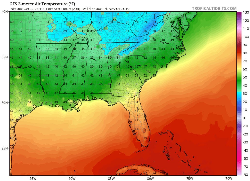
Halloween is getting closer (within reasonable model range). Looking like the kids will be wearing coats over the costumes.
6z GFS at ~ Trick or Treating time (next morning many areas below freezing):

-
 3
3
-
-
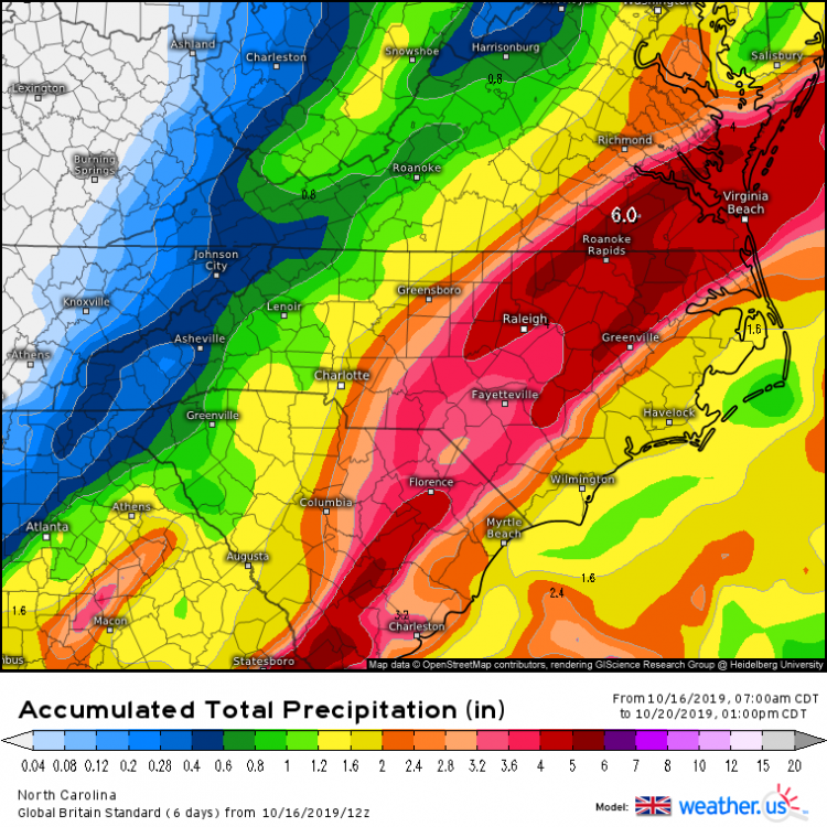
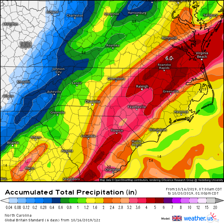
6z NAM continues to show some nice rains over the SE. The 6z GFS has joined the party and has shifted its precip shield farther west to give many in Ga, SC, and NC good amounts (~1" from Atlanta - Greenville - Charlotte - RDU) . Sharp cutoffs going into S.VA.
-
36 minutes ago, NC_hailstorm said:
12z Ukie is bringing the hammer Sunday for eastern parts of NC/SC.Gulf low right up the coast.
I'm grateful for the rain we got today, but we need a good soaker to fill some of these ponds...
-
 1
1
-
-
RAH used the frost word. They're highlighting "normally colder locations"; which I'm not. But maybe places in central/eastern NC like Sanford, Roxboro, and even Rocky Mount could see something.
.LONG TERM /Thursday through Tuesday/... As of 224 PM Tuesday... Quiet, cooler weather in store for central NC Thursday through Saturday, and even dry weather most of Sunday. The main weather story during this time will be temperatures, with a cold Canadian high settling over the Carolinas by Friday morning. While Thursday morning will see lows in the lower 40s, it will be even chillier Friday morning with lows in the upper 30s possible, and even a few patches of frost possible in the normally colder locations. Otherwise, look for gradually moderating trend over the weekend as the high moves off to our east. The next noteworthy wx system will be a plume of tropical moisture progged to lift NE out of the GOM and cross the Carolinas early Monday morning through the day Monday. That will provide the first of two rain opportunities early next week. The second rain opportunity will be associated with a cold front progged to cross the area on Tuesday.
-
25 minutes ago, Orangeburgwx said:
GFS WHAT ARE YOU ON FOR HALLOWEEN?!?!


Sent from my SM-S327VL using Tapatalk
That wouldn't be surprising for the higher elevations, but for Kentucky that would be a little early.
The nice thing is we're in a totally different world from two weeks back.
-
1
-
-
4 hours ago, gman said:
Looks promising.
Personally I would love this outcome. But man that is a skinny strip of precip. One shift south or north and I'm crying the blues while others are celebrating. **wish it was more widespread...
-
3
-
-
2 minutes ago, Lookout said:
Expecting my 3rd in a row 100 degree high temp...was 101 yesterday. I cant believe this is October... Beyond ridiculous..wildlife and trees are probably confused as hell too lol. Just letting back to normal temps will be a shock to the system. And the dust...ugh...I really really hate drought.
It's coming. The pattern is breaking and most folks across the SE will be cool(er) from now into LR. We might actually be looking at some cold air in 10 days or so; whereas we could be talking frost.
The thing I really hate about this heat wave is it took some prime weather away from us; meaning I enjoy opening windows and not having to use AC or heat. We could be looking at a year where we go, within a couple of weeks, from AC to heat.
-
1
-
-
11 hours ago, cbmclean said:
Is it too early to start looking for a fantasy -NAO? From the CPC 8 - 14 day forecast.
One feature being closely monitored is the potential for ridge development over the North Atlantic south of Greenland (shown by the GEFS and ECMWF ensembles). Should this feature develop, this would teleconnect well with increased troughing across much of the Eastern CONUS.
Nothing could go wrong here could it?
I personally think this would be a great time (moving towards winter) for a trough pattern to set up across the east. I've always been in the camp of (wanting a) east coast trough in early/mid October, ridging from late October into mid November, and then a trough pattern in late November / early December. My thinking is the pattern that occurs around Thanksgiving can be a signal for the winter. This goes along with our past (half) joking about not wanting a Halloween storm or SC November snow.
-
1
-
-
3 hours ago, Upstate Tiger said:
We arrived yesterday for our first OBX trip and this had just occurred. Very very sad
https://www.wbtv.com/2019/10/02/national-weather-service-official-drowns-while-swimming-outer-banks/
That's truly sad. It seems there have been a lot more deaths this year attributed to rip currents.
-
So for many of us, Friday is the transition day. The front will come through early in the day, The farther north you are in the SE, the earlier you'll see the cool down (..or dew point drop). Specifically for RDU, we'll see dew points drop from the mid 60s early in the day to mid 50s by 6pm. High temps will still reach the mid 80s but drop into the upper 70s with the lower dew points by 6pm (..it'll be a nice evening for a walk).
-
1
-
-
7 hours ago, donsutherland1 said:
In parts of the South, monthly record high temperatures were shattered. Monthly records included:
Birmingham: 99° (previous October record: 94°, 10/1/1919, 10/5/1927, and 10/6/1954)
Chattanooga, TN: 97° (previous October record: 94°, 10/5/1954)
Huntsville, AL: 99° (previous October record: 96°, 10/8/1911)
Lexington, KY: 97° (previous October record: 93°, 10/6/1941)
Louisville: 96° (previous October record: 93°, 10/7-8/2007)
Mobile: 97° (previous October record:95°, 10/2/1904)
Montgomery, AL: 101° (previous October record: 100°, 10/6/1954)
Nashville: 98° (previous October record: 95°, 10/1/1953, 10/5/1954, and 10/8/2007)
Pensacola: 96° (previous October record: 95°, 10/8/1884 and 10/5/1951)We're buckling up for another two days of historic heat. from RAH:
.SHORT TERM /THURSDAY AND THURSDAY NIGHT/... As of 355 AM Wednesday... ...DAY 2 OF RECORD/HISTORICAL HEAT... In response to the upper trough progressing east across the Great Lakes and into the NE US by Thursday night, the upper heat ridge will begin to weaken late Thursday and Thursday night, but not before one last day of record heat. With the pocket of 20 to 21 C H8 temps still residing over the region, the EC indicates thicknesses will rise another 10 meters from Wednesday, which is usually good for 2 to 3 degrees of warmth with highs expected to top out in the mid to upper 90s. These temps will shatter daily record highs and quite possibly challenge the all-time hottest October temperature of 98 and 95 degrees at RDU and GSO respectively. Heat indices in the low 100s are expected from the Triangle, south and east. Once again, will highlight these indices in the HWO. The shortwave trough into the NE US will propel a moisture starved backdoor cold front south through the Mid-Atlantic region Thursday night. Latest model timing brings the cold front towards our northern border right around daybreak. Still mostly clear. Overnight lows in the upper 60s to lower 70s.
-
1
-
-
Well it's not so bad today. Expected high in the low/mid 80s. But Thursday is going to be the killer. My grid forecast has 97! I honestly didn't think it could it could get that high with the lower sun angle and higher dew points (usually need much dryer air to allow for higher temps this time of year).
-
The 6z GFS looks to at least get most of us back to normal (..averaged through the end of the run) starting this weekend. Nothing really cold but it would be beautiful fall weather if it verifies.
-
I don't know^^, models are definitely showing a cool down for the end of next week. The average may not be too far below normal but at least it'll be below normal. The GFS would have highs in the 60s with lows ~50 a couple of days. With all the heat we've had, that's something to get excited about....
-
1 hour ago, superjames1992 said:
Helena, MT is forecasted to get 8-12" in a few days and the Marias Pass is forecasted 36-50". Not bad.
I like seeing that region (and up into SW Canada) get early snow. That's were some of our cold will come from later in the season.
-
1 hour ago, yotaman said:
Partly cloudy, warm, and humid out there today. Currently 85/74. 9 days till the next strong cooldown.
Looks like it's still coming. One good thing about hoping for the cool down (over say a snow storm), we know it'll eventually come.
-
 1
1
-
-
2 hours ago, kvegas-wx said:
I understand the thinking but disagree with the word "large". The runoff and flooding would be devastating. What would be better is a 2-3 back to back small tropical waves that dump a couple inches each over weeks, not days. My yard here in the triad is concrete. You throw 4-8" of rain on top of that and everything runs off. We need slow and steady.
You're absolutely right. If we can't get anything tropical, we'll have to hope for a wet late fall/winter. Oh and some nice snows would do the job as well.
")
-
8 minutes ago, Solak said:
I hate to say it, but I think we need a large tropical system to hit ~ the Florida panhandle and then move NE.
Mid to Long Term Discussion 2019
in Southeastern States
Posted
Yep, many areas do not get above freezing for highs one day. That would be something to see in November.