

FallsLake
-
Posts
6,317 -
Joined
-
Last visited
Content Type
Profiles
Blogs
Forums
American Weather
Media Demo
Store
Gallery
Posts posted by FallsLake
-
-
currently 85 degrees at RDU, but the dew point is 48! Getting some dry desert heat...
-
25 minutes ago, Upstate Tiger said:
Starting to feel like fall of 2016. Hope we don't start seeing the wildfires like we had that year. Remember the all the smokey days?
I sure do. We need rain. I dare say we need a tropical system. Otherwise we might have to wait for the November storms to start.
-
7 hours ago, Iceagewhereartthou said:
Welp, after another day of runs the post 25th cool down is now completely gone and the heat continues to build through the end of the run. The 18z GFS wants to push a pretty big front across country the first week of Oct, though verbatim, I'm not sure it would make it past the mtns. Enjoy the next few days fellas!
6z GFS is more positive. It now shows a couple of cool downs and then warm ups. Better than all warm; which some earlier runs showed. **Precip is still not good across the SE.
-
^^Yeah, I've seen it hot (90s) into early October (..like last year). I've also seen it get cool (no AC needed again) after the first week of September. The last two Septembers have been warm; and last October was warm into middle of the month, but then the dam broke and fall finally arrived:
-
The only good thing I can see (model wise) about the next couple weeks, is that the NW US and SW Canada start to truly cool down after day 10. This will be our source for October cold (..hopefully frost/freezes).
-
 1
1
-
-
6 hours ago, Iceagewhereartthou said:
My kids were at soccer practice this evening and it was plain nasty outside. Worst September ever!
Last year was bad as well. Looks like after this brief cool down, it'll stay hot into early October.
-
for many of us Fall will start tonight (weather wise):
.SHORT TERM /WEDNESDAY THROUGH WEDNESDAY NIGHT/... As of 128 AM Tuesday... The post-frontal stratocumulus/stratus should be mostly confined to the Piedmont Wednesday morning, then skies are expected to become partly to mostly sunny in all areas in the afternoon. A refreshing NE breeze will advect in much drier and cooler air. Expect highs only in the 70s, except a few lower 80s near the NC/SC border area. Then, mainly clear and cool Wednesday night. The most comfortable night in recent memory. Lows in the 50s, with some upper 40s north- central Piedmont. &&
-
21 minutes ago, Fantom X said:
Being from NY, i am enjoying the extended summer. I always felt (living up there) that summers were way too short.
With that said, I am not enjoying this dry spell. 20th day in a row with no rain IMBY
Fall is normally beautiful here. If we're lucky we can get 4-6 weeks of open window weather.
-
We do get a break this week.
from RAH:
.LONG TERM /WEDNESDAY THROUGH SUNDAY/... As of 245 AM Monday... Much cooler and drier Wednesday through Friday, followed by a gradual warming trend over the weekend. High pressure is expected to extend into NC/SC from the north Wednesday through Friday. It will be much cooler and drier with very noticeable drops in both temperature and humidity expected. Sunny days and clear nights are forecast Wed-Fri, lows in the 50s. Highs in the mid 70s to around 80. The normally cool spots over the Piedmont will have some mid-upper 40s. The ridge aloft will build back into the region from the west over the weekend. This will allow the surface high to remain nearly stationary over our region Sat-Sun. A gradual warming trend will begin Saturday with highs in the 80s, after lows in the mid 50s to near 60. Highs Sunday should reach the upper 80s to around 90 with dry weather to continue. &&
**Those cooler spots are places like Sanford and Roxboro.
-
Definitely feel the difference this morning with the frontal passage. Cooler and overcast with a stiff NE wind. Still not the cool crisp dew points we're waiting for but a good break from the last couple of days.
-
2 hours ago, Isopycnic said:
Still waiting, again.... Hopefully I wont be Oct 11th this year.
First hint, Sept 25th
But, the models have been showing this in the LR for the last week or so. I'm afraid it'll just keep getting pushed back with each run. We've seen this before.
-
1
-
-
7 hours ago, Tarheel17 said:
The only saving grace is that +1 degree C is equivalent to 59 L and 80 H by the end of this timeframe in Charlotte....

Yeah, we're already getting temps in 80s/60s while we're in a bad pattern. In July this would be at least 90s/70s.
Last year we started to see some foggy nights in mid/late September. We kept the higher dew point, and with the longer nights allowed the air to saturate. Looks like we might see more foggy nights this year...
-
3 hours ago, FLweather said:
2 years ago Irma made landfall twice in FL.
Was a rough storm for sure around here.
70-85 winds/gust. About a foot of rain.
Was a miserable 8 days before the power came back on.
12 GFS still has the storm ~ Puerto Rico at day 7. Afterwards it shows it trying to recurve out to sea; but that's out in la la land. So anything is possible at this point.
-
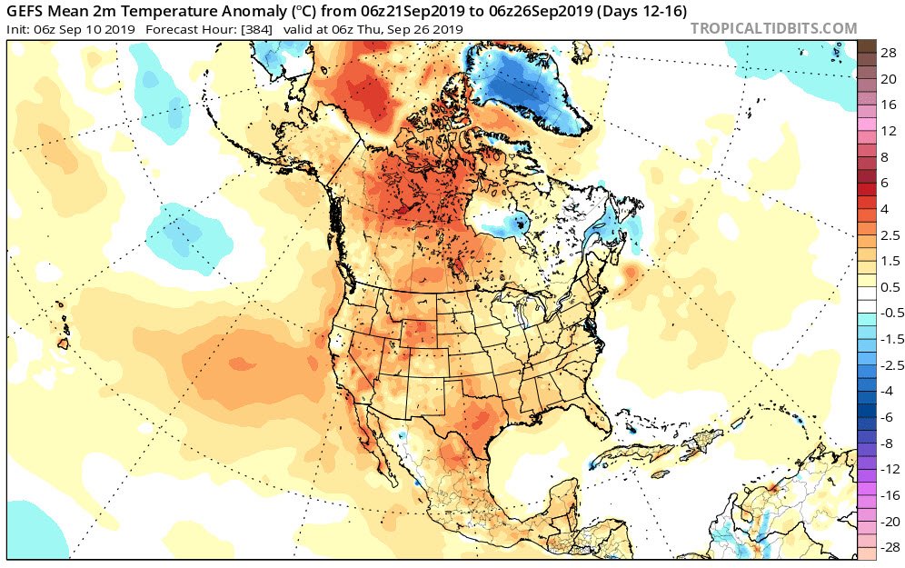
14 hours ago, kvegas-wx said:
If we lock in the SER again and sweat through October I think at least 70% of this board will need some sort of mental therapy. The long range models are just not good at predicting pattern changes.....ever. #trustbroken
Hopefully the 6Z GEFS is not good in the LR (2m temp anomaly for days 12-16):
-
24 minutes ago, griteater said:
There were a couple of screwy things that happened last winter:
1. We had an official sudden stratospheric warming on Jan 1-2, but it didn't propagate down into the troposphere so we didn't get the -NAO and eastern trough that you would expect to see with a SSW/El Nino combo (unlucky)
2. Just at the time when you would think that El Nino would be exerting it's max influence on the pattern in February, we ended up with a February that looked like La Nina with a PNA of -1.73 and record snowfall in Seattle (odd)

There was a lot of hype about a cold winter. Some of us did get lucky with the December storm, but otherwise it was a bad winter.
-
33 minutes ago, griteater said:
Here's a long term trend chart for Dec-Feb temperatures for North Carolina

Looks like a pattern. Everybody has heard of the 30s heat (dust bowl), maybe we'll start dropping back in the coming years. **not considering climate change.....
-
I like the 12z NAM. It looks to keep the storm off the coast right up to hour 84. I'm sure the outer banks would still see some damage. But on a selfish note, it would pull down some nice low/mid 50s dew points into central and eastern NC.
-
22 minutes ago, FLweather said:
Not sure if weakening or going through EWR. But the eye looks ragged and has gotten bigger via radar out of the Bahamas.
Definitely stationary atm. Just wobbling over Freetown.
I feel bad for those folks. A lot of the buildings are not built to withstand that kind of (prolonged) wind.
-
1
-
-
2 hours ago, Powerball said:
Gotta say, while I'm generally good with no snow, getting whiffed to the south by a 12"+ snowstorm (in GA of all places) would definitely piss me off.
Lol, yeah I was just joking with NRVwxfan. He moved from Columbia to SW Virginia and is rightfully expecting to see more snow. But it would funny to see a couple of southern sliders this year like the one shown. **I've been saying for the last two years we're due to see one of these storms.
-
5 minutes ago, Queencitywx said:
looks like 6z HWRF takes it into between CHS and Georgetown up through Myrtle.
For us in the Triangle, we'll be very close to the cut off line for excessive rain. 50 mile difference in the track will give folks in central NC 5" or very little.
Lol, we'll probably have the Wake County cut off. But it will be opposite (then many winter storms) for the haves and have nots...
-
2
-
-
12 GFS looks like it rides just off the coast of the SE with maybe a touch of a landfall in SE NC. Would be bad for coastal NC. ^^as SENC just stated..
By the way, I'm having issues with Tropical Tidbits. It keeps wanting me to tour the sight (I have to hit skip for each click I make). Anyways to stop that?
-
9 minutes ago, superjames1992 said:
12z ICON is a Miami hit. Is that model worthless for tropical weather? Odd to see.
They're talking about that now in the main forum (some saying its worthless). I would say it's another possible solution.
-
1
-
-
So we'll be dealing with higher tides as the storm approaches. You have probably been hearing about the King Tides. These are times of the year where the tides are higher than normal. Early next week we'll be experiencing one of these events. This may be a bigger deal for Florida (storm off shore and the high tides occurring at the same time); but as the storm approaches us we could see earlier then normal storm surge (even as the storm is still far to our south).
http://nckingtides.web.unc.edu/how-to-participate/calendar/
-
 1
1
-
-
2 minutes ago, downeastnc said:
Still so far out I am skeptical/optimistic, the issues for us are the turn keeps happening farther east this keeps the storm further away from land and this should lead to a stronger storm up the coast. One saving grace with earlier runs was IF it does end up in NC the track was right on or just off the coast this would weaken the storm quite a bit, the further east it stays the less chance it weakens as much. The upside is the further east it is the more likely it is to turn OTS and miss all together. The thing to watch now is the energy in the mid west the models hint at that could capture Dorian or a significant increase in timing and less of a slowdown when/if it turns which would allow Dorian to get farther north ( onshore NC ) before kicking out....
Yeah, I guess we're in the sights now. One other thing to look at is how fast this storm moves. With Florence it was the flooding from a slow/stalled storm. So as you said, if it's weaker and then if it's also fast moving, a SC/NC hit may not be too bad.
Sept 2019 Observations
in Southeastern States
Posted
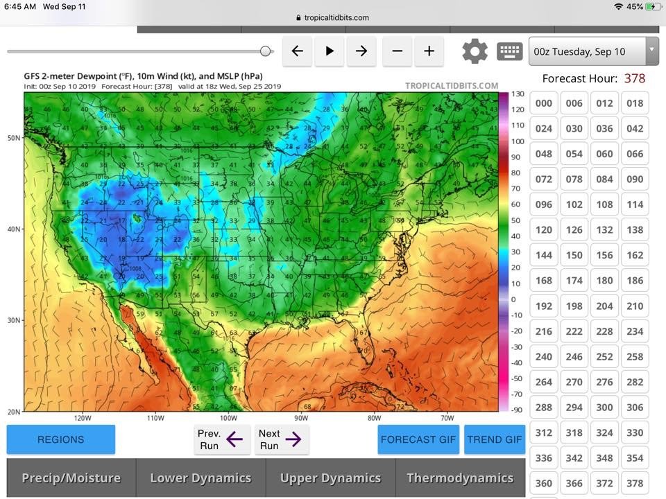
^^Looking at the NWS map it looks like the dew points will spread a little eastward this afternoon:
https://graphical.weather.gov/sectors/midatlantic.php?element=MaxT