

FallsLake
-
Posts
6,317 -
Joined
-
Last visited
Content Type
Profiles
Blogs
Forums
American Weather
Media Demo
Store
Gallery
Posts posted by FallsLake
-
-
22 minutes ago, mackerel_sky said:
May be by noon today, if GFS trend continues!? It’s way North of yesterday’s runs!
Not sure if it's a trend. It seems like the difference between the 0z and 6z GFS is that the 6z develops a storm much earlier. Now if you're looking at yesterdays 18z, there was a shift north between that run and 0z. But it seems the 6z GFS has leaned towards the euro of developing a storm on day 8.
-
This would be the cold we need to setup the potential storm afterwards:
From RAH:
The forecast over the weekend is uncertain, yet the next system should bring more rain into the weekend - followed by a very cold high that may nose into our region (potentially more aggressively than most of the cold highs that have affected the upper Mid-West into the Ohio Valley so for this winter season).
-
So, the 0z euro had two different potential storms from day 8 to 10. Both didn't produce much but again it wouldn't take much for that to change. At this time range we have to expect big difference between each model run (storm, no storm, storm.....). In a couple of days we would expect it to settle down some; hopefully showing a storm.
The 6z GFS has a nice snow storm for a large portion of NC up into VA. FV3 has the storm but it's suppressed.
So just looking at these three models (..considering GFS and FV3 different) there's definitely still a strong storm signal.
-
9 minutes ago, mackerel_sky said:
The 18z GFS is so suppressed, nothing shows up during the 4-7th! Winning!
The big thing is it still shows a storm. The 18z FV3 has a light event, which wouldn't take much to be much larger (but again details....). So basically all major models showing a potential storm at day 9.
-
 1
1
-
-
^^A good run for the euro. Again don't look at the details; all that matters is it shows a storm with available cold air (in the area).
But if you do want to see the details (which will change next run), here you go:
-
Yeah, that was a good run for both the GFS, Fv3 and CMC. Can't look at the details (past day 7); just know a storm with available cold (in the area) is showing.
-
2
-
-
An absolute miserable day. Just under 2" and it's been in the upper 30s/low 40s the whole day.
-
12 minutes ago, Solak said:
RAH this morning:
Late week, all major models tend to slide a backdoor cold front
through the area initiating CAD type conditions late Thursday into
Friday morning as a SFC coastal low begins to develop to our
southeast. These features will be worth watching closely, as some
sort of wintry mix may be possible assuming a strong enough CAD and
a close tracking Miller-A or Miller A/B style pattern sets up. Temps
should remain seasonable all week, with highs in the upper 50s/lower
60s while lows dip into the 30s/low 40s.
Yeah the euro is hinting at this along with the 6z FV3. Of course the FV3 would then continue into a big winter storm at days 9/10/11.
-
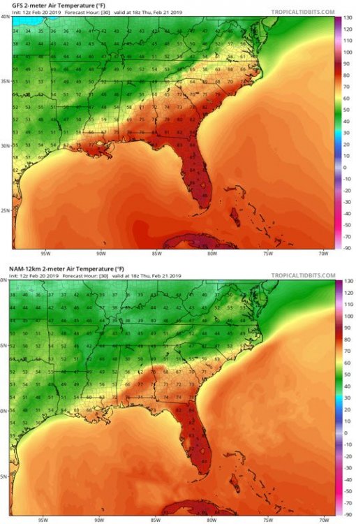
So does the CAD over-perform or under-perform tomorrow. 12z GFS Vs NAM, near mid-day:
-
1
-
-
42 minutes ago, frazdaddy said:
Technically speaking I believe for mine and your area this event was accurately forecasted and did not.
Yep, temps and freezing rain coverage this morning matched a lot of the model output (..for our area).
So here's the next test for CAD over-performance (...lets see what it does on Thursday):
.SHORT TERM /THURSDAY THROUGH THURSDAY NIGHT/... As of 325 PM Tuesday... The CAD will slowly erode on Thursday. But, residual affects will last much of the day with a light steering flow. Areas of fog, mist, and drizzle will continue through at least late morning. Highs generally upper 40s and 50s. Much of the guidance still show 70+, but this seems way over done unless it clears out much more quickly and abruptly than currently expected. So, we can go with some 60s for a compromise.
-
Every situation is different. If you're strictly looking at if the temp is below or above temp, then yes it's overstated. But, if you're looking at the lasting power of a CAD then it does seem to over-perform. There has been many bust to the colder side when CAD has been forecasted to erode.
-
1
-
-
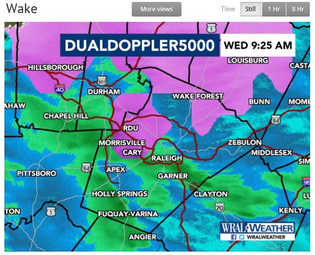
Here's WRAL's current radar (with types):
-
19 minutes ago, Queencitywx said:
7/20 GEFS ensemble members have warning criteria events at the beginning of March for GSO and RDU. 5/20 for CLT.
That time period could be our last chance. We have a pretty defined winter period where we can get snow. Usually it's early December to early March. Of course folks can quote storms (...93) outside that range, but they're rare.
-
So at 8am RDU is sitting at 32/30 with light rain.
-
Might still get a little freezing rain this morning for the northern Triangle folks and to the north/west. Radar is filling in some and temps are near/at/or slight below freezing. RDU is at 33 with a dew point of 30. Wouldn't amount to much but again it's interesting.
-
Still had some residue sleet/snow on the porch and cars this morning. Temp was right at freezing but nothing was falling.
It was fun being under those heavy bands last night. At one point, I was 50/50 sleet/snow with big flakes.
-
Well I have to sign off for the night. Still have the reality of a job tomorrow. Maybe this thing continues to overachieve overnight.
Down to 33.1 degrees.
-
I'm in some kind of winter purgatory. Keeps trying to go to snow but then switches back to sleet.
-
Big flakes coming down!
-
1
-
-
Just now, Queencitywx said:
Roads getting slushy over here. Your way?
Ground has a white look and the porches and cars are white. Streets look ok. I'm still at 33.6 degrees but its been dropping steadily.
-
Any reports up in Granville County or over to Roxboro? Snow??
-
2 minutes ago, bannerdude said:
Sleet is accumulating on most elevated surfaces here. Haven't seen snowflakes yet.
See that heavy/bright band running through Durham into north Wake County:
https://weather.cod.edu/satrad/nexrad/index.php?type=RAX-N0C-1-24
You want to be just north of those returns (which represent sleet).
-
2 minutes ago, Queencitywx said:
Wondering about those bright echoes around Siler City and southern Chatham.
Must be heavy sleet. It looks like I'm in the same band your in. If we can get that (the bright returns) to push south we would be in all snow.
-
Seeing more snow again.

Mid to Long Term Discussion 2019
in Southeastern States
Posted
Here's the 6z GFS snow map: