

FallsLake
-
Posts
6,317 -
Joined
-
Last visited
Content Type
Profiles
Blogs
Forums
American Weather
Media Demo
Store
Gallery
Posts posted by FallsLake
-
-
As others have stated, we're not going to get a good model read on the sensible weather past 7 days. Indices are good for something to occur for the next two weeks. That's all we have at this point. I wouldn't be surprised to see another huge storm at 12z for the day 9/10(or 11...) period just to have it disappear at 18z (or vise versa).
PNA - Stays positive until the LR, then it goes neutral; which others have stated could signify a whole continental trough.
NAO - Looks to average negative
AO - Looks to go and stay strongly negative
https://www.cpc.ncep.noaa.gov/products/precip/CWlink/daily_ao_index/teleconnections.shtml
-
2 minutes ago, Wow said:
Too lazy to research but has there ever been recorded single digit highs for the piedmont area of NC?
And in a non-storm situation (...March 1980 had temps fall into the single digits during the day). I know there has been sunny days with highs in the teens, but single digits I don't know.
-
Just read RAH discussion. As of last night they are siding with the euro’s more north track. But they did mention the GFS and of course this discussion was before the 6z came out.
So hopfully the euro corrects south today.
-
Just now, mackerel_sky said:
It’s been on since yesterday’s runs, and is better than Euro, it’s all we got!
Did other models show it? Asking because. I’m in Boone visiting family and haven’t been able to check model runs to well on my phone.
-
Problem with the 6z GFS is it doesn’t have support from other models and the event is close at 6/7 days out. Other models would need to trend quickly today for this to be “real” or I would sucspect the 12z GFS is going to go back north.
-
 1
1
-
-
11 hours ago, yotaman said:
So far for me:
1. Nope
2. Nope - short one coming - 1 day and 2 nights
3. Nope
4. Nope
Other than a chance of flurries early Monday morning, I don't see any real chances of snow, sleet, or freezing rain this month. Hope I am wrong but I don't think so.
I keep saying this, but you guys are due. I actually think this is the perfect "forecasted" pattern to give coastal areas snow. Strong blocking with strong highs that can suppress the storm track way south. Then when something does pop, you guys snow. **also if it gets cold enough, it would be cool to see bay effect snow again.
-
2 minutes ago, mclean02 said:
Whew not sure if that has happened in Greensboro before 10 degrees and snowing ! lol

You wouldn't have to worry about ratios.
-
2 hours ago, NCSNOW said:
at 96/ 12z : May help with some back side

Has support from the EPS and now the 18z NAM. Still not excited, but keeping an eye on the (slim) possibility.
-
We don't know what's going to happen:
-
39 minutes ago, Northern Foothills Snowman said:
Brad Panovich has a good video this morning on the cold coming. Brad Panovich Twitter
That was a good video. Everybody that wants to jump should see this first.
-
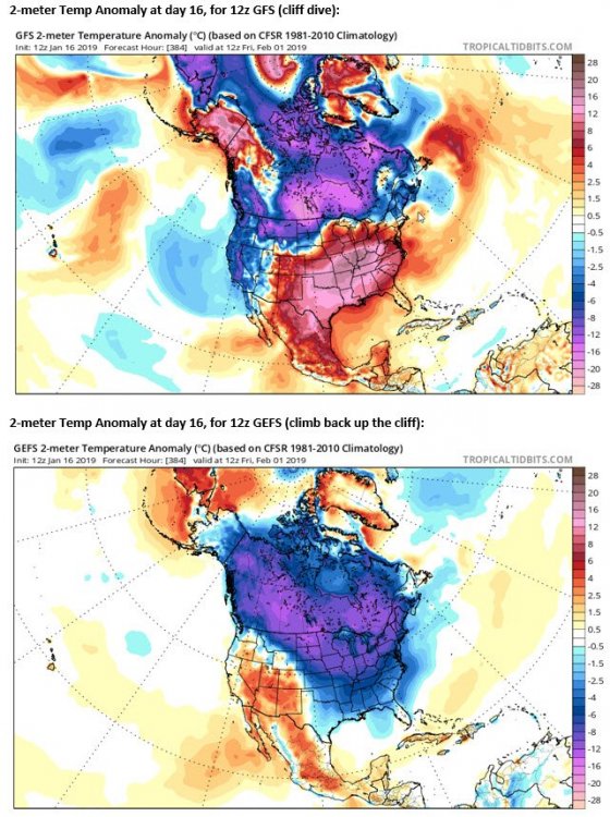
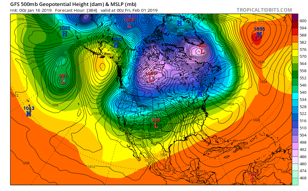
7 minutes ago, Cold Rain said:
You do NOT want energy to start getting shunted out into the SW and off the west coast, causing a trough out there unless you have a big time west -NAO pressing the vortex south. You don't want it split either, having a piece over western Canada and one over eastern Canada with a weakness in the middle for storms to work into.
This is not a good look at all. Fortunately, it's the 0z 384 Op GFS. So it's unlikely to evolve this way.

The 6z looks like this. Even worse:
.thumb.png.7e130c2ca9d3973dab53c4ca03a6209e.png)
You can see the storm track NW of our location (story of the past few weeks). Hopefully with this pattern change the models are having difficulties; especially the American models because of all the talk of low maintenance (..budget impasse).
Just looking out 10 days, the euro does look good. Maybe it's the model that will lead all the others:

-
1
-
-
1 minute ago, Looking to the skies said:
The 25th 05 26th.....look at the teleconnections. The EPS and GEFS agree on this. Every one of these goes into the most favorable position they could, all synchronized perfectly.
-AO

-NAO

+PNA

-EPO

If I remember some of the discussion on the above indices, a -PNA is not bad if we have the AO, NAO and specifically the EPO on our side (all negative).
Usually when I see a -PNA I think we're done for...
-
1 hour ago, DownS.EasternVa said:
Models have been trending southward in regards of wintry precip on Sunday. 6z Fvs now drops 3-5in of frozen precip across northern NC into S. & Se Va. Could be a decent event for those area's. Its still time to get it a lil more south, considering there are strong H pressures over top and behind the Arctic front. Wouldn't be surprised if models show more wintry precip as the front gets closer.
Some mets have discussed this in days past, but most have backed off. 6Z FV3 is really the only model showing anything (halfway) significant. Maybe something starts to show on more models in coming days but right now I wouldn't count on it. **this is where our friends on the other side of the mountains can actually score a small event. Our mountains are great for CAD but (in this case) usually slow the cold air down too much to catch moisture.
-
2 minutes ago, NCSNOW said:
Where have all the clippers gone to this winter? Be nice to see one when we are at max suppresion. Those are the only ones we can get to halfway work east of the apps. The ones that go down into Albabma, Georgia underneath the NC 6,000 ft peaks, then swing back up off the coast.
I think they're coming. We just haven't had deep enough troughs to get them going yet.
-
1 minute ago, southernskimmer said:
This is my second winter in Matthews, NC. I have yet to see more than a half inch of accumulation. A lot of us south of 85 are due for a monster
Yeah, the upstate of SC up to your location have had bad luck the last couple of years. There's been numerous storms where you're suppose to get a big storm and it doesn't pan out. That's probably worse then the folks farther east that were never in the game to get anything.
-
40 minutes ago, *Flash* said:
Not to downplay any concerns of an empty-handed pattern change, but it's only fair to point out many locales in middle TN/other SE forum areas at/under 35°N haven't seen a flake of snow this winter. Not only have most of you had a grade A winter already...but you've had solid storms the past three winters. With much of this forum locked in an entertaining/memorable weather zone in recent years, count your blessings. You've been on the feast side way more often than the famine side.
I have no complaints, but there are folks in SE NC, SC ,and Ga that are in a long snow drought (maybe half the board??). I would love to see at least one deep south and coastal snow storm; even if I got shutout. It seems like its been ages since the last one.
-
 1
1
-
-
2 hours ago, superjames1992 said:
My winter checklist is a single flake of snow falling from the sky. I don't think that's going to happen, though. At least I saw snow on the ground when I went skiing, I guess?
I actually got to see it snow twice last year (here in Tallahassee with our "historic" dusting in early January and about 1" in Greensboro while visiting in late March). I also saw it snow while I was on a vacation in Scandanavia in May 2017. But this winter I might get shut out.

Take a look at the latest FV3. But you might be a little too far north...

-
1
-
-
4 minutes ago, Orangeburgwx said:
From my lifetime, 2010 comes to mind, but i got lucky with that Coastal Crusher last year
If we get the cold that's advertised, folks in south Ga, east SC, and coastal NC could get a huge storm. Many to the west may stay cold/dry (for a specific storm).
-
2
-
-
Indices continue to look good:
PNA - Briefly gets to neutral in the short term but goes back positive into the LR
NAO - Looks to go negative in the LR (this may help suppress our storm track)
AO - Man it almost tanks off the charts (that's going to drive some cold air southward)
http://www.cpc.ncep.noaa.gov/products/precip/CWlink/daily_ao_index/teleconnections.shtml
-
1
-
-
17 minutes ago, PackGrad05 said:
We just don't get big snows in NC with very cold air. Often times, the cold air has to be right at freezing or marginal so that the storms aren't suppressed all the way down south.
Some of the coldest Januarys I've seen had very little snow. In those years it seemed February came through to save the day (...just from memory).
-
18 minutes ago, wncsnow said:
The pattern change looks like crap right now. Next 10 days have no real threat and after that we will basically be in February. This blockbuster winter is quickly going down the drain...
With the pattern change and with so much cold air moving into the US, I think we can only use the models out to about day 9. We're seeing big swings in the later days with each model run. The one big constant is the availability of cold air. It still may be early February until something pops, especially if we get unlucky with the day 10-16 period. But the euro weeklies and many mets think the rest of winter is going to be on the cold side. I think we're looking good.
On a side note; many have posted what they would consider a good (A score) winter. I have four things:
1) Significant snow event (Check----already had the 12" in December)
2) Significant arctic outbreak, with at least a couple of sunny days with highs below freezing (looks like that is coming)
3) Significant winter event, which can be a mixed bad but has to limit driving, etc. (waiting)
4) Small winter event, which can be mixed bag but is picture worthy (waiting)
-
42 minutes ago, JoshM said:
Wish that wasn't the end of the run...


What's so fun about this GFS run, is there is another storm right after this one that gives all the folks shown with rain above a coastal snow storm. If a solution like this was to occur (exactly as modeled), North and South Carolina would have snow cover over all (mountains to coast) of both states. I don't think I've ever seen that.
-
1
-
-
RAH not very impressed with the snow chances next weekend, but I like their talk about the cold (gives me chills):
Significant flow amplification, spanning multiple streams, is forecast next weekend into early next, with a resultant full latitude trough forecast to migrate from the cntl US on Sat to the East Coast by Mon, and following cross polar, nwly flow delivered all the way to the Sunshine State. Deepening low pressure will accompany the trough aloft and cross the srn-cntl Appalachians and middle Atlantic states late Sat through early Sun. While preceding mild, warm sector flow should envelop much of the sern US and Carolinas, some degree of cold air damming, from clouds and rain that will overspread the nrn and wrn Piedmont on Sat, may hold those areas in an appreciably cooler regime (40s), versus the growing warm sector 50s-60s elsewhere late Sat-early Sun. A half an inch to an inch of rain-soaking appears likely Sat night, with sharply colder temperatures --and the leading edge of 1040-1045 mb Arctic high pressure-- plunging across cntl NC Sun afternoon and night. A limited spatio-temporal overlap of departing deep moisture and incoming cold suggests any changeover from rain to snow on the back side of the frontal system would be very brief, on the order of an hour or two at most, and consequently light and non-impactful. More impactful will be the aforementioned incoming Arctic airmass, which will likely produce the coldest temperatures of the season, and a legitimate risk of sub-zero wind chill values, by Mon morning.
-
1
-
-
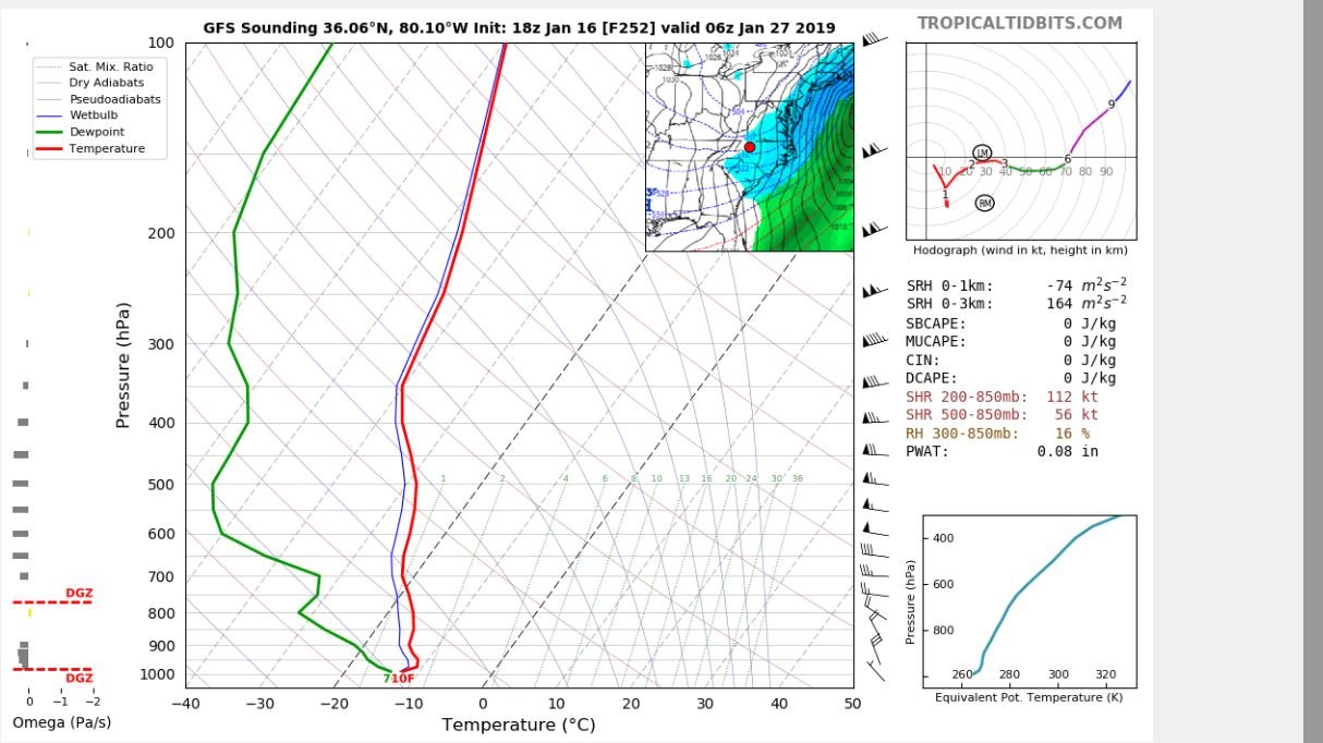
Here's day 16. If we still end up getting rain it will be rain storms over frozen ponds:
Edit: Could you imagine the lake effect snows...

-
1
-

.png.d77c312cb8aca8e28ecdf9c8535da716.png)

Mid to Long Term Discussion 2019
in Southeastern States
Posted
They switched to a point of the FV3 is now showing a nice storm and the GFS not. But the FV3 still had the storm signal at 0z. This would be nice for the folks down east in SC and NC.