

SouthCoastMA
-
Posts
6,397 -
Joined
-
Last visited
Content Type
Profiles
Blogs
Forums
American Weather
Media Demo
Store
Gallery
Posts posted by SouthCoastMA
-
-
31 minutes ago, Hazey said:
55cm (22”) final at my place. YHZ reporting 84cms(33”) but that might be suspect as it seems high. Cape Breton sold 2-4ft reports with a few 5vers thrown in. Incredible storm and one that will be long remembered in the Maritimes.
Not bad for some rogue Baffin Island s/w.George should start more threads for you guys..seems like it worked inadvertently
-
It has been tough to muster more than a dusting with these 5-10dBZ snow showers.
-
 1
1
-
-
I'm personally not even looking at the OPs past 4-5 days. Can't do it anymore, for my own sanity
-
8 minutes ago, CoastalWx said:
Boring AF.
I'll be tracking the potential for a coating tomorrow. Exciting times!
-
Shift that omega block 400 miles to the west and SNE gets a HECS, not Nova Scotia. Bad luck
-
11 minutes ago, brooklynwx99 said:
March is 10 times more of a winter month for most than December. unless you're far inland or pretty decently north
SSTs are still cold here in March so that helps. Still in the mid 40s to low 50s through December
-
1
-
-
19 minutes ago, ORH_wxman said:
ridging in Greenland starting to appear as well?
-
I wish I measured correctly for 1/22/05 though it was pretty difficult. Had between 26-28" depth the next day
-
some flurries this AM. maybe a few more OE snow showers Tuesday/Wednesday. hasn't really amounted to much
-
Dueling aside, maybe a few flurries on the South Shore / Cape tomorrow morning/midday?
-
35 minutes ago, Prismshine Productions said:
.

Sent from my SM-S146VL using Tap
Still living at 300+ hours I see. This would normally get you a 21 bun salute.
-
3
-
-
GFS finally catching on to boredom
-
3
-
 3
3
-
-
-
This is an OG George thread, Only thing missing is the B word
-
GFS and GEFS took a slight step back at 6z with upper level configuration. I'd be highly skeptical outside of some snow showers along the coast, unless other models start coming aboard. It is crazy how different the GFS and Euro are though with the handling of the ridging.. a lot of moving pieces at play so still something to watch for some (not RUNNAWAYICEBERG)
-
maybe some oe snow showers..an inch in spots?
-
1
-
-
The hook and lateral is a trick play in American, Canadian football and indoor American football, often colloquially called the hook and ladder play
It's either hook and lateral OR hook and ladder (colloquiall version). No such thing as a hook and latter from what I'm reading
-
 1
1
-
-
Just now, dendrite said:
I anxiously await this
 period. Dry it out for a bit, get another biggie, and then let’s Morch.
It definitely beats whatever abomination occurred all last week. concur
-
some models showing .1-.15 in that timeframe. Tiny Tim doesn't complain when he gets scraps
-
44 minutes ago, CoastalWx said:
Maybe some light snows in Southeast mass early next week?
Glad you said it not me. Im already on probation for mentioning that yesterday. Maybe someone lucks out with a spot 1 or 2"
-
https://www.cbsnews.com/boston/news/snow-totals-boston-massachusetts-january-30-2018-storm/
I don't remember that one either but apparently had an 8 spot at my old residence
-
1 minute ago, brooklynwx99 said:
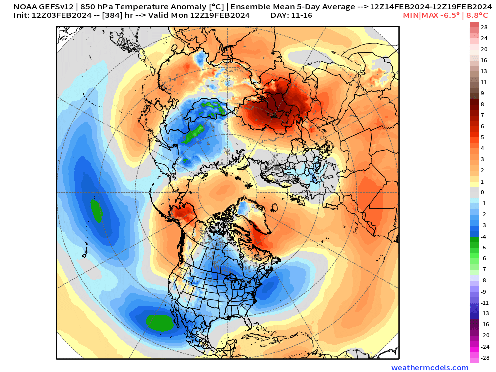
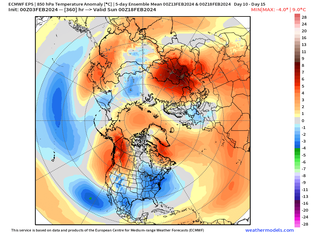
everything still looks on track for mid-month... MJO moving into favorable phases, equatorward Pacific jet extension will foster strong Aleutian low development, split flow, building -NAO via wave breaking in the N Atl. all ensembles are in really good agreement temporally and spatially
i'd like to give it another week to get this into a better range, but it looks good

-
14
-
-
42 minutes ago, Lava Rock said:
don't do it man, just dont
lol sage advice. just bored, not invested
-
1
-
-
Not to change everyones favorite subject, but CMC and ICON have trended closer with Day 7 storm, resulting in some CJ for coastal areas. It looks like those models want to push a lobe from that northern stream vortex SW, causing that block to be further west. GFS and EURO are not having any of that idea at the moment.

It was a Flop... February 2024 Disco. Thread
in New England
Posted
I'd sign up for something like the Euro OP has - 970mb SE of the benchmark
And agreed that there are plenty of interesting ensemble members to not keep an eye on it