mimillman
-
Posts
3,468 -
Joined
-
Last visited
Content Type
Profiles
Blogs
Forums
American Weather
Media Demo
Store
Gallery
Everything posted by mimillman
-
The cold in January was very rewarding to experience. Other than that, winter on both sides of the year Q1 and Q4 2019 were totally meh in the city. The past couple years feels like we’ve had more winter in the shoulder months (November, March, April) than winter itself.
-
Winter 2019-20 Medium/Long Range Discussion
mimillman replied to Hoosier's topic in Lakes/Ohio Valley
00z Euro looks much better after the storm next week and finally showing signs of the PV breaking down in the 8-10 day range. I’m optimistic about mid Jan -
Winter 2019-20 Medium/Long Range Discussion
mimillman replied to Hoosier's topic in Lakes/Ohio Valley
Long range GFS after the system mid next week looks good. Just gotta get through the next week. -
Winter 2019-20 Medium/Long Range Discussion
mimillman replied to Hoosier's topic in Lakes/Ohio Valley
Wondering if this torch is actually helping to warm up the lake and will come to bite us in January during any onshore flow events. -
Winter 2019-20 Medium/Long Range Discussion
mimillman replied to Hoosier's topic in Lakes/Ohio Valley
The polar vortex is mega mega mega strong. Everywhere in the world is warmer than normal, except the arctic. -
Winter 2019-20 Medium/Long Range Discussion
mimillman replied to Hoosier's topic in Lakes/Ohio Valley
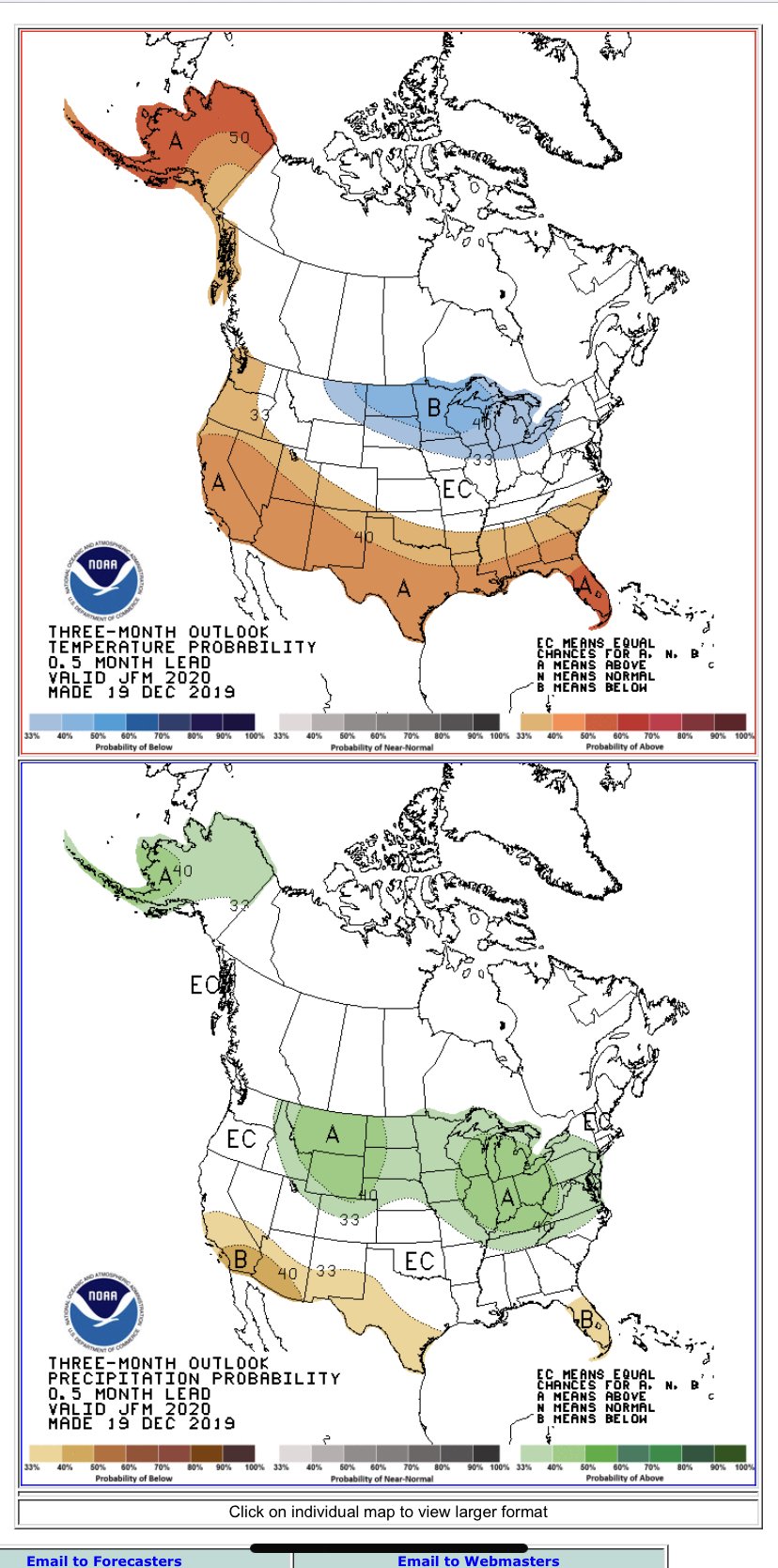
NOAA calling for a major turn around J/F/M
-
Winter 2019-20 Medium/Long Range Discussion
mimillman replied to Hoosier's topic in Lakes/Ohio Valley
One of the strongest PVs I’ve seen in a really long time...the Arctic probably seeing one of its coldest Decembers in quite some time. Must be global warming -
Winter 2019-20 Medium/Long Range Discussion
mimillman replied to Hoosier's topic in Lakes/Ohio Valley
Pretty big improvements from the 12z GFS by end month. -
Autumn/Winter 2019-2020 Banter/Complaint Thread
mimillman replied to IWXwx's topic in Lakes/Ohio Valley
Thank you so much for posting this. Was just returning down memory lane, this was the event that got me into weather in the first place, back when I lived on the East Coast.
-
Winter 2019-20 Medium/Long Range Discussion
mimillman replied to Hoosier's topic in Lakes/Ohio Valley
But you need a system like that and something bigger to bring about a pattern shift, regardless of rain or snow -
Winter 2019-20 Medium/Long Range Discussion
mimillman replied to Hoosier's topic in Lakes/Ohio Valley
Still strong, consolidated PV. Really need that to breakdown to get something more impressive/sustainable. -
Winter 2019-20 Medium/Long Range Discussion
mimillman replied to Hoosier's topic in Lakes/Ohio Valley
I mean it still sucks but admittedly there’s more action in the long range than before. GFS and Euro both hinting end month -
Autumn/Winter 2019-2020 Banter/Complaint Thread
mimillman replied to IWXwx's topic in Lakes/Ohio Valley
Wow what a god awful December -
Autumn/Winter 2019-2020 Banter/Complaint Thread
mimillman replied to IWXwx's topic in Lakes/Ohio Valley
not worth even looking until after Christmas -
Winter 2019-20 Medium/Long Range Discussion
mimillman replied to Hoosier's topic in Lakes/Ohio Valley
I’ll take a warm December if it means a cold and snowy January any year. -
GEM trying to pick up on some lake enhancement. It’s the only model really showing that though, so probably nothing.
-
NAM bias is typically for a more amped solution this far out, isn’t it? In that case I’d prefer it to show a cutter over the Dakotas as this juncture lol
-
I’d argue it’s similar to the Canadian with the secondary development off the coast. I wouldn’t bet against those two unless the trend continues with the 12z suite.
-
Improvement, but not quite enough
-
Snow mixing in now, but yea big bust here
-
Nada downtown and RN
-
smells like bust
-
The GFS has initialized about 2 degrees colder than current obs at MDW
-
Think temperature has been stagnant at 40 degrees for close to the last 4 hours
-
RN- downtown