

mimillman
-
Posts
3,333 -
Joined
-
Last visited
Content Type
Profiles
Blogs
Forums
American Weather
Media Demo
Store
Gallery
Posts posted by mimillman
-
-
10 minutes ago, A-L-E-K said:
call looking $$$
I’m still taking under for you mate
-
 1
1
-
-
Mt Geos FTW
-
1
-
-
4 minutes ago, SchaumburgStormer said:
Euro ticked north through IL
Actually temps aloft are colder than prior runs
-
 1
1
-
 1
1
-
-
2 minutes ago, SchaumburgStormer said:
Tossing one of the more consistent models thus far is a bold call, although I would not take its snow output verbatim near the lake.
That’s more what I mean
-
11 minutes ago, King James said:
GFS a toss?
Yes
-
5 minutes ago, SchaumburgStormer said:
The screw hole of all screw holes.
Cary going to love this
-
1
-
 1
1
-
-
10 minutes ago, A-L-E-K said:
we will have zero otg when the rain hits
Not convinced but wouldn’t be surprised
-
40 minutes ago, A-L-E-K said:
not our event
Best result would be the small period of rain is under light returns and doesn’t do too much to what will have already fallen
-
35 minutes ago, Baum said:
LOT AFD:
IN FACT, WARMING TEMPERATURES INTO THE MID TO
UPPER 30S SOUTH OF I-80 DURING THE DAY FRIDAY SHOULD SUPPORT A
TRANSITION OVER TO JUST RAIN FOR A SEVERAL HOUR PERIOD. WE COULD
EVEN SEE RAIN AT LEAST BRIEFLY MIX IN WITH THE SNOW AS FAR NORTH
AS THE I-80 TO I-88 CORRIDORS INTO MIDDAY FRIDAY AS TEMPERATURES
BRIEFLY WARM A BIT ABOVE FREEZING.Can’t say disagree
-
The euro is going hard on a 2-3 hour period of rain in the immediate metro between 18-21z tomorrow.
-
10 minutes ago, A-L-E-K said:
6" of 5:1 concrete or bust
I think that’s still possible. 00z Euro had mixing and poor ratios in the city
-
The GEM is further south with its track which allows temps aloft to become much for favorable for LOT including immediate metro. QPF is lower but progged snow totals are higher. Verbatim even downtown would achieve warning criteria snows.
Not to mention the track is more favorable for lake enhancement.
-
4
-
-
GFS is starting to hint at subsidence somewhere around the I-80 corridor. I trust it won’t be until showtime that we know exactly where that sets up but someone will get screwed by it
-
No issues immediately accumulating on paved surfaces here tonight. Prime it for Friday
-
2
-
-
RGEM is solid
-
1
-
-
10 minutes ago, hawkeye_wx said:
It is ripping hard here, the heaviest snow of the season. The comma head of this potent little disturbance is about to go over me with very intense snow.
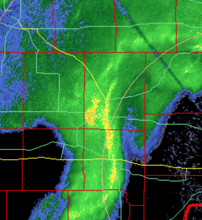
Was wondering where you were
-
7 minutes ago, mimillman said:
NAM in process of caving
It’s a messy process
-
2
-
1
-
-
NAM in process of caving
-
Lol no good deed goes unpunished
-
1
-
3
-
-
5 minutes ago, HillsdaleMIWeather said:
18Z Euro is slightly east and a tiny bit weaker
It also gets 0c line a bit further north into Cook county and verbatim would be an hour or two of rain for the city and points south.
-
10 minutes ago, Chicago Storm said:
They like to avoid that situation, because it is indeed a downgrade.
Think the main thing to avoid is endangering lives
-
1 hour ago, Chicago Storm said:
A watch for downtown and near lake areas seems highly questionable at this point. At least for now...
I think it’s prudent. It can always be downgraded
-
Once again the Euro manages to keep 0c 850mb south of the immediate metro, very different from last storm. Ratios will be very poor but this should be very heavy snow as progged. The NE burbs will do very well.
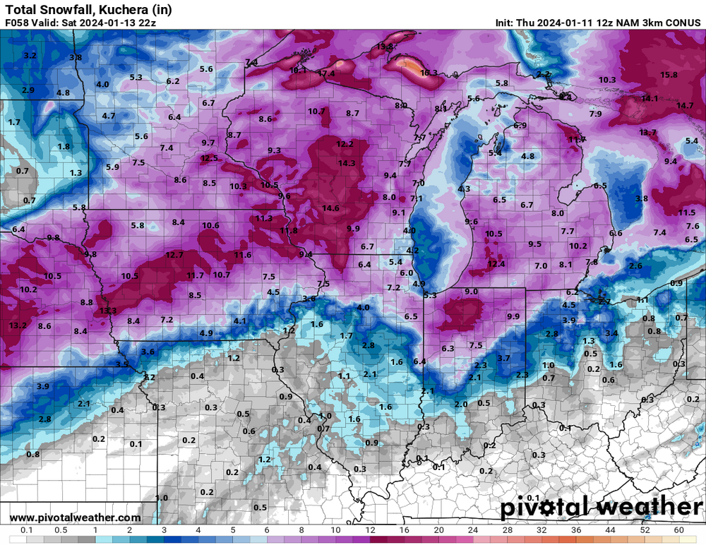
I made a final call of 3-5” for the city. That may still be accurate but could be low for the NW neighborhoods. ORD and northwest of there should be 6-10”
-
2
-
-
Just now, A-L-E-K said:
bigger event at ord tonight or friday?
I’m going to sell the NAM and say Friday but I’m weary
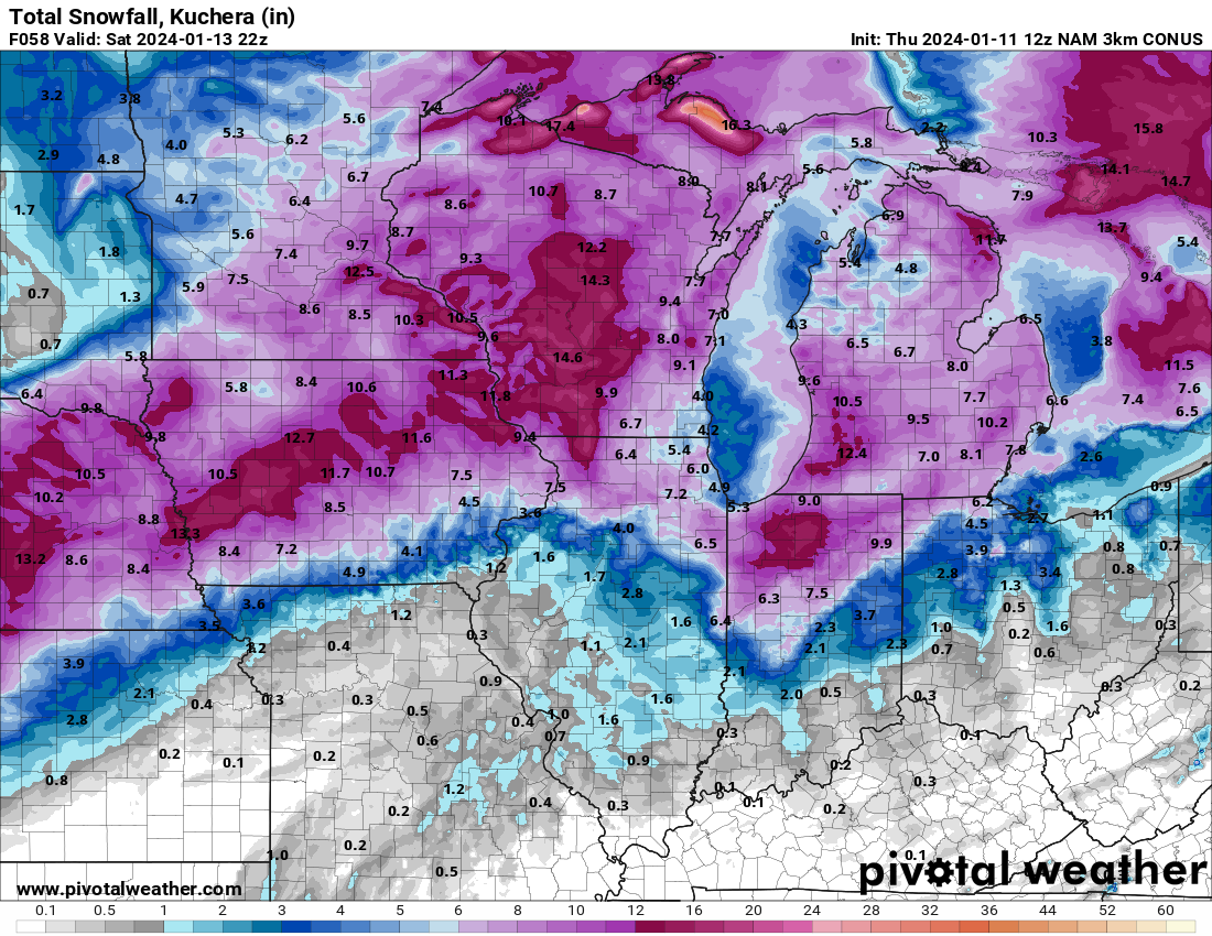

Jan 11-13th Blizzard
in Lakes/Ohio Valley
Posted