DeltaT13
-
Posts
3,006 -
Joined
-
Last visited
Content Type
Profiles
Blogs
Forums
American Weather
Media Demo
Store
Gallery
Everything posted by DeltaT13
-
Upstate/Eastern New York
DeltaT13 replied to BuffaloWeather's topic in Upstate New York/Pennsylvania
It certainly is blossoming nicely. What I like to see even more is the synoptic snow and low level moisture slowly working down through Ontario towards the lake. That should be what really kicks things into high gear, -
Upstate/Eastern New York
DeltaT13 replied to BuffaloWeather's topic in Upstate New York/Pennsylvania
Hi Res NAM really lights up overnight for entire south shore. Will be interesting to see if that lobe of moisture and shortwave ignite the lake this evening. The cold air is still lagging behind so I don't think we have to start panicking just yet. Also, I realize this is literally as weenie-ish as you can get, but Hour 384 on the 12z GFS is pretty much the most perfect Miller A one could hope for. Almost looks like 93. What a beaut, enjoy it while you can as it will be gone by the 18z run. haha. The East coast is active though over the next few weeks, we just can't get the timing right.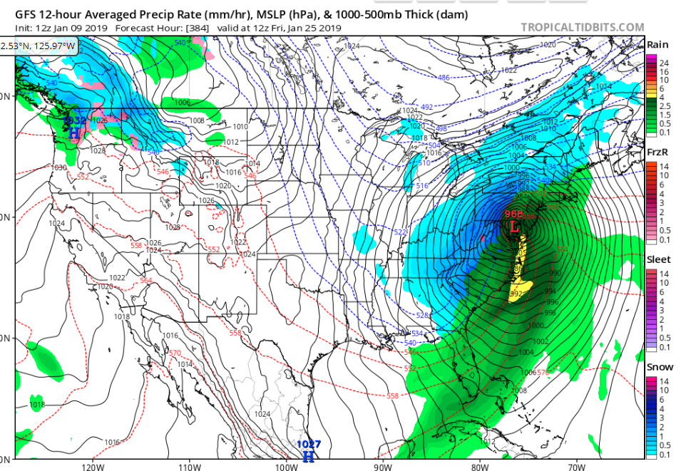
-
Upstate/Eastern New York
DeltaT13 replied to BuffaloWeather's topic in Upstate New York/Pennsylvania
Thanks! The prices of trucks are truly astronomical these days. My last truck was an 04 f150 so I had been holding out for a long time and the time had come. I'm hoping to have this truck for 10 years though, but it was still a big leap to take. Absolutely sucks to have a payment again (and a big one at that). At least I have a reliable ride for the foreseeable future. -
Upstate/Eastern New York
DeltaT13 replied to BuffaloWeather's topic in Upstate New York/Pennsylvania
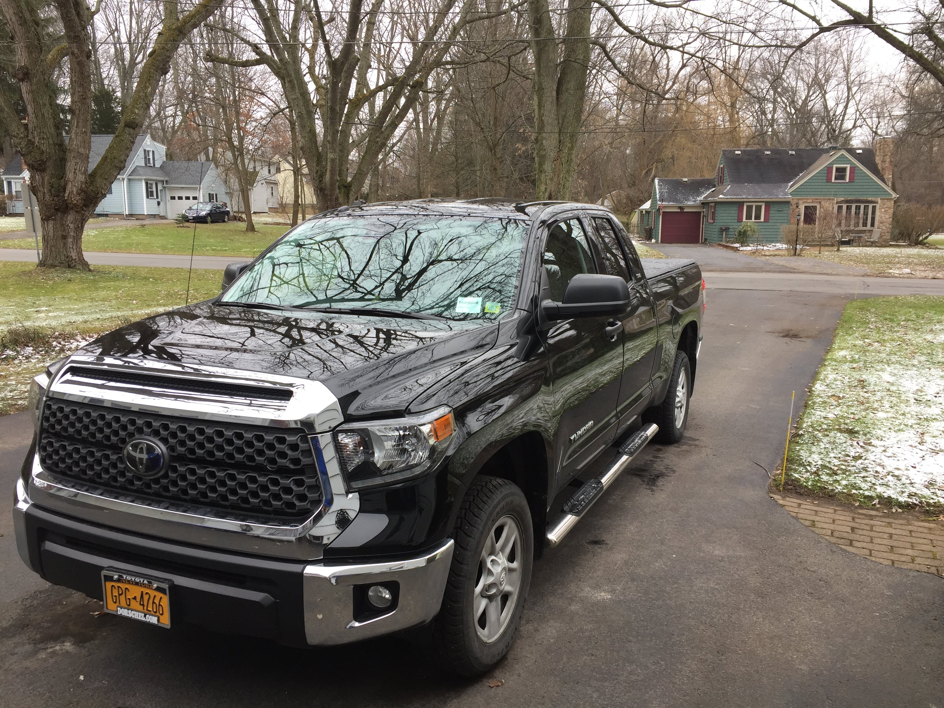
Here is my brand new ride, yet to be tested in the snow .... it’s 4x4 with studded snows. It should hold its own. Can’t wait to try her out!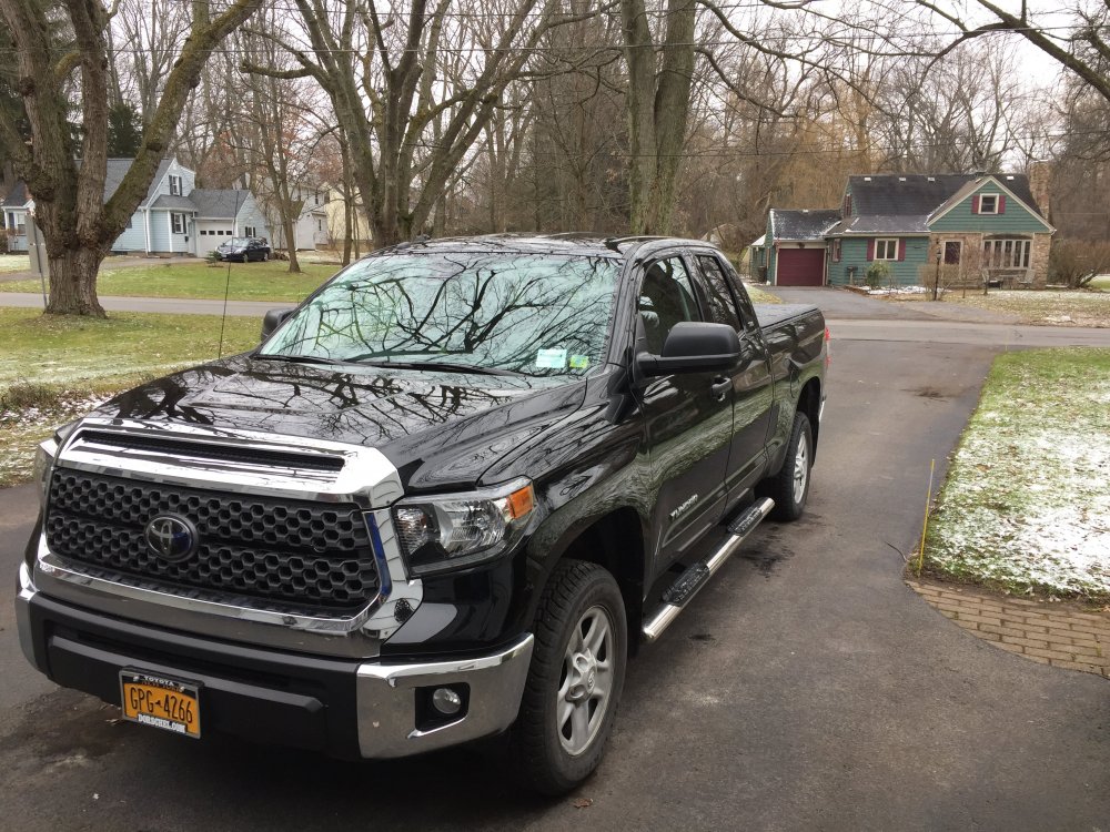
-
Upstate/Eastern New York
DeltaT13 replied to BuffaloWeather's topic in Upstate New York/Pennsylvania
Thanks Dave! There is a lot of info one could extrapolate from those graphs. I wish they would update the last few season already. -
Upstate/Eastern New York
DeltaT13 replied to BuffaloWeather's topic in Upstate New York/Pennsylvania
Hey ROCdave, can you post that interesting graph you found of the days with at least 1inch of snow on the ground from like the past 100 years. I have looked back but cannot find where or when you posted that. Very interesting information in there. -
Upstate/Eastern New York
DeltaT13 replied to BuffaloWeather's topic in Upstate New York/Pennsylvania
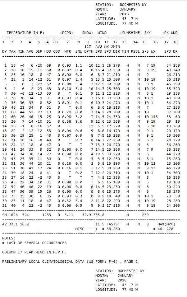
Does anyone remember this week last year? BRUTAL cold with highs in the single digits for several days. A cut off low was stalled over New England and it tapped into a cross polar flow of arctic air. Lake Ontario sprayed grit onto the South Shore for days and days straight. Only ended up with 5 or 6 inches but snow was in the air for days. I could use some of that love right now. Looking at the CF6 I'm reminded that we rebounded to well above normal the following week and the rest of the month was somewhat of a bust aside from the storm on the 12th and 13th.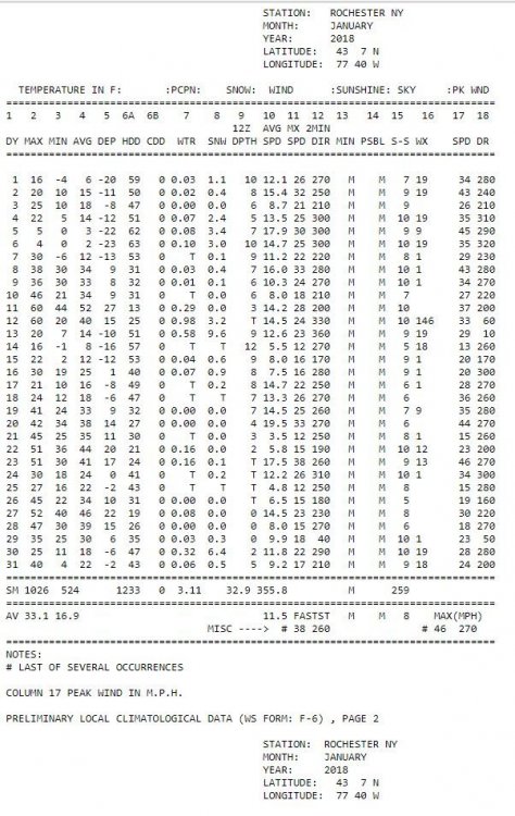
-
Upstate/Eastern New York
DeltaT13 replied to BuffaloWeather's topic in Upstate New York/Pennsylvania
I bought a new snowblower and a brand new 4x4 Toyota Tundra the first week of December. I havent had to use the snowblower yet and havent even turned on 4x4 once on the truck. Add me to the blame pile. -
Upstate/Eastern New York
DeltaT13 replied to BuffaloWeather's topic in Upstate New York/Pennsylvania
Looks like 3 nice rainstorms on the 12z GFS over the next couple weeks. You can't make this stuff up. There is just NO cold air to work with and storm tracks North of the Great lakes for run after run after run. Just brutal. -
Upstate/Eastern New York
DeltaT13 replied to BuffaloWeather's topic in Upstate New York/Pennsylvania
Nearly all the 18z runs have that sfc low a tick further north putting wny in a really ideal spot for damaging winds tonight. Will be a hell of a way to ring in the new year. Really liking this setup and excited to see what unfolds as there isn’t much else to hang our hats on these days. Haha. -
Upstate/Eastern New York
DeltaT13 replied to BuffaloWeather's topic in Upstate New York/Pennsylvania
Snow Ridge has really struggled as they rely heavily on natural snow and lake effect. Killington will mostly open but a lot of manmade snow at this rate. We are in the same boat as I have several trips already reserved and paid for. -
Upstate/Eastern New York
DeltaT13 replied to BuffaloWeather's topic in Upstate New York/Pennsylvania
If we are going to miss a snowstorm by 150 miles, at least we end up with a nearly perfect track for a significant high wind event. One of my favorite types of weather. I'll take anything I can get at this point. -
Upstate/Eastern New York
DeltaT13 replied to BuffaloWeather's topic in Upstate New York/Pennsylvania
Sadly, something doesnt necessarily have to give. Seems like about every 5 years or so we have a winter without any real winter. We all know just 5 years ago we had a year where Buffalo had less than 40 inches total on the season. Rochester won the golden snowball that year with less than 70 inches on the season. We are somewhat overdue for a dud winter as we had 4 pretty solid years in a row here. It figures this is the year I plan the most ski trips into the Northeast. So disheartening. I'm thinking of starting up some yard projects (running power out to the shed) to at least make use of this garbage winter. -
Upstate/Eastern New York
DeltaT13 replied to BuffaloWeather's topic in Upstate New York/Pennsylvania
Man I've been trying to stay positive, but with every model run, the reality of a crappy winter seems more real. Looks like we can almost write off the first 2-3 weeks of January. Just no blocking, pac air dominating NA, and a split flow that seems to move any system of interest either well North or well South.. We havent even had a damn high wind event yet this fall/winter. Losing faith..... -
Upstate/Eastern New York
DeltaT13 replied to BuffaloWeather's topic in Upstate New York/Pennsylvania
Wow, ugly stuff on that radar. 0z NAM confirms a green christmas in the ROC with a dearth of moisture by the time we are cold enough. I was really hoping we would eek soemthing out tonight, just a coating would have made me happy.. -
Upstate/Eastern New York
DeltaT13 replied to BuffaloWeather's topic in Upstate New York/Pennsylvania
12z GFS definitely looks like a solid inch for Rochester on the back end of this first system, with another quarter inch or so on Sunday night and then a dusting on Christmas. I give Rochester a solid 75 percent chance of having marginal "white" Christmas. -
Upstate/Eastern New York
DeltaT13 replied to BuffaloWeather's topic in Upstate New York/Pennsylvania
He means the four people who post here. And also, it’s called hyperbole. You say similarly exaggerated things everyday. Chill the f out. -
Upstate/Eastern New York
DeltaT13 replied to BuffaloWeather's topic in Upstate New York/Pennsylvania
The Geminid meteor shower has really lived up to its fireball reputation this year. Is it clear out there? -
Upstate/Eastern New York
DeltaT13 replied to BuffaloWeather's topic in Upstate New York/Pennsylvania
Ice is an insulator, if ice continued to flow down the river, the lake could actually cool more quickly in your scenario as liquid water would continually be exposed to cold air. That said, the impact is negligible relative to the scale of that lake. Also, there have been studies on the ice boom and spring temps and absolutely no correlation was found. The ice boom protects homeowners along the river and prevent issues with hydro electric power, but that boom is so tiny relative to the size and volume of lake Erie that no tangible weather effects have ever been observed. It's all Buffalo Folklore. I should add, that maybe a mile or two directly around the boom might have a slightly colder day or so during a tiny time period right around the removal time if there was still pack ice, but overall this is virtually in the noise http://niagara.nypa.gov/ALP working documents/finalreports/html/IS39.htm -
Upstate/Eastern New York
DeltaT13 replied to BuffaloWeather's topic in Upstate New York/Pennsylvania
I can't be sure, but my intuition is that is has very little effect on the overall freeze up of the lake. Ice flows would just start jamming up around the peace bridge pretty quickly on their own. The boom just allows them to control where the jamming occurs. -
Upstate/Eastern New York
DeltaT13 replied to BuffaloWeather's topic in Upstate New York/Pennsylvania
Thats actually not the worst little band right now. I bet there is some downright moderate snow in there..gif.b1f802eec40f0fa1b62536dbd2eb715f.gif)
-
Upstate/Eastern New York
DeltaT13 replied to BuffaloWeather's topic in Upstate New York/Pennsylvania
Kind of a glancing blow on the HIRES NAM, by the time it gets juicy its heading south. Still looks like a Solid 3 hours for Northern Erie which could be 6 inches or so. If it can get started earlier than that model depicts it might overachieve. Also, It does come right near rush hour which should be taken into account when they drop watches. I'm pulling for you guys.
-
Upstate/Eastern New York
DeltaT13 replied to BuffaloWeather's topic in Upstate New York/Pennsylvania
I'm getting the heaviest snow of the whole event at the absolute ass end, lol. Better late than never I guess. -
Upstate/Eastern New York
DeltaT13 replied to BuffaloWeather's topic in Upstate New York/Pennsylvania
Stop looking at them and putting so much faith in them! It's like you never learn...lol They are just worst case scenario maps from the get go -
Upstate/Eastern New York
DeltaT13 replied to BuffaloWeather's topic in Upstate New York/Pennsylvania
Friday looks dry, Saturday looks dry until late evening, some scattered showers overnight, and then Sunday looks dry all day. What am I missing?