DeltaT13
-
Posts
3,006 -
Joined
-
Last visited
Content Type
Profiles
Blogs
Forums
American Weather
Media Demo
Store
Gallery
Everything posted by DeltaT13
-
Upstate/Eastern New York
DeltaT13 replied to BuffaloWeather's topic in Upstate New York/Pennsylvania
What is going on in here? So much doom and gloom. The start to winter has been early and strong, not sure what y'all are complaining about. The way I see it almost everything we have gotten so far is straight bonus snow. Many years I would still be waiting on my first real coating or inch of snow on this date. Just a few years back Buffalo didn't even get its first measurable snow until after Christmas. It could be much worse! Additionally, that arctic front looks viscous. Wouldn't be surprised if someone heard a rumble of thunder in it. The NWS is dropping snow squall warnings for it.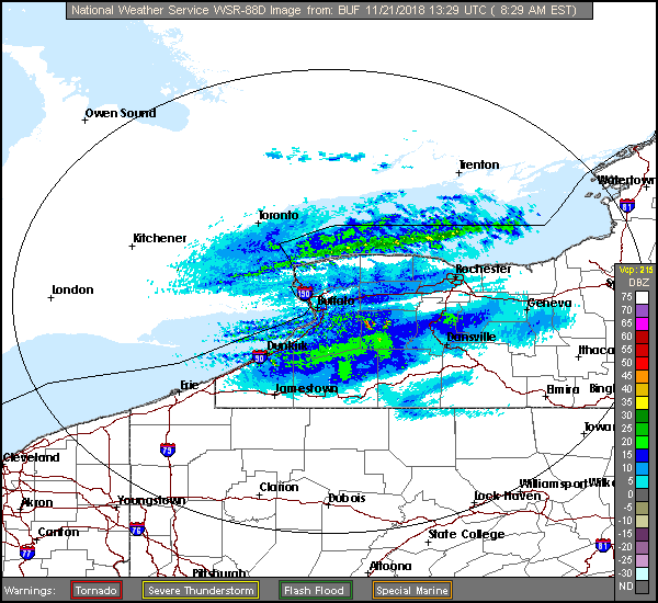
-
Upstate/Eastern New York
DeltaT13 replied to BuffaloWeather's topic in Upstate New York/Pennsylvania
Yeah, I see that now that other reports are trickling in. Canandaigua area was a local jackpot for sure. -
Upstate/Eastern New York
DeltaT13 replied to BuffaloWeather's topic in Upstate New York/Pennsylvania
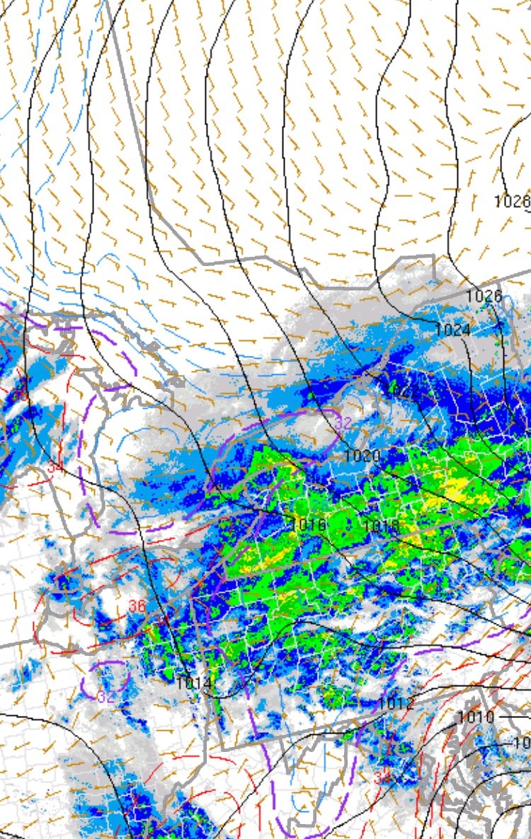
Spotter Reports National Weather Service Buffalo NY 937 AM EST Fri Nov 16 2018 ********************STORM TOTAL SNOWFALL******************** LOCATION STORM TOTAL TIME/DATE COMMENTS SNOWFALL OF /INCHES/ MEASUREMENT NEW YORK ...Allegany County... Andover 12.0 530 AM 11/16 Social Media Wellsville 12.0 500 AM 11/16 Co-Op Observer 1 N Belmont 10.0 753 AM 11/16 Mesonet Alfred 10.0 700 AM 11/16 Co-Op Observer Rushford 9.6 800 AM 11/16 Co-Op Observer ...Cattaraugus County... Perrysburg 8.3 755 AM 11/16 Co-Op Observer SSE Ischua 7.4 700 AM 11/16 CoCoRaHS Little Valley 7.0 700 AM 11/16 Co-Op Observer Cattaraugus 6.5 800 AM 11/16 Co-Op Observer 1 NNE Franklinville 6.3 707 AM 11/16 CoCoRaHS 1 N Humphrey 6.0 600 AM 11/16 CoCoRaHS 6 SSE Delevan 5.0 801 AM 11/16 Mesonet ...Cayuga County... Port Byron 15.0 555 AM 11/16 Social Media 1 W Port Byron 10.5 730 AM 11/16 Trained Spotter ...Chautauqua County... Jamestown 6.2 633 AM 11/16 Trained Spotter NE Kennedy 6.0 600 AM 11/16 CoCoRaHS 3 N Celoron 5.5 600 AM 11/16 CoCoRaHS 2 SW Forestville 5.5 730 AM 11/16 CoCoRaHS Silver Creek 5.0 730 AM 11/16 Co-Op Observer 4 ENE Jamestown 5.0 700 AM 11/16 Co-Op Observer NE Clymer 5.0 800 AM 11/16 Mesonet 5 WSW Randolph 4.7 430 AM 11/16 CoCoRaHS Fredonia 4.0 300 AM 11/16 Trained Spotter 1 WNW Fredonia 4.0 500 AM 11/16 CoCoRaHS 3 SSE Frewsburg 3.5 619 AM 11/16 CoCoRaHS 2 SW Fredonia 3.0 801 AM 11/16 Mesonet 1 SW Dunkirk 1.0 700 AM 11/16 CoCoRaHS 1 S Dunkirk 1.0 700 AM 11/16 Co-Op Observer ...Erie County... Concord 10.0 631 AM 11/16 Dept of Highways Sardinia 8.5 649 AM 11/16 TRAINED SPOTTER ESE Hamburg 7.5 751 AM 11/16 CoCoRaHS WSW Hamburg 7.0 700 AM 11/16 CoCoRaHS 2 SE Glenwood 7.0 800 AM 11/16 CoCoRaHS 1 SSE Eden 6.3 700 AM 11/16 CoCoRaHS 1 W Colden 5.0 730 AM 11/16 Co-Op Observer 2 NE Boston 5.0 800 AM 11/16 CoCoRaHS 2 SSW Blasdell 4.5 700 AM 11/16 CoCoRaHS Wales 4.2 700 AM 11/16 Co-Op Observer 2 SSE East Aurora 3.9 700 AM 11/16 CoCoRaHS 1 WNW Alden 3.8 630 AM 11/16 TRAINED SPOTTER 1 W West Seneca 3.7 700 AM 11/16 CoCoRaHS ENE East Aurora 3.6 700 AM 11/16 CoCoRaHS 3 WSW Elma 3.5 700 AM 11/16 CoCoRaHS 2 WNW West Seneca 3.5 745 AM 11/16 CoCoRaHS 3 NNE East Aurora 3.5 700 AM 11/16 CoCoRaHS 2 NNE Tonawanda 3.0 755 AM 11/16 CoCoRaHS 2 NW Cheektowaga 2.8 735 AM 11/16 CoCoRaHS 3 NE Cheektowaga 2.8 700 AM 11/16 CoCoRaHS Buffalo Airport 2.8 822 AM 11/16 Co-Op Observer 5 NNE Amherst 2.7 800 AM 11/16 CoCoRaHS ESE Kenmore 2.7 720 AM 11/16 CoCoRaHS 3 NE Tonawanda 2.0 700 AM 11/16 CoCoRaHS 3 E Williamsville 1.6 700 AM 11/16 CoCoRaHS ESE Clarence Center 1.5 725 AM 11/16 CoCoRaHS 1 W Lakeville 1.4 700 AM 11/16 Co-Op Observer ...Genesee County... 1 E Le Roy 8.0 715 AM 11/16 Co-Op Observer 1 NW Batavia 4.5 730 AM 11/16 CoCoRaHS 2 NE Stafford 4.5 700 AM 11/16 CoCoRaHS ...Jefferson County... SE Mannsville 8.2 700 AM 11/16 CoCoRaHS Watertown 8.1 900 AM 11/16 Trained Spotter 1 NE Belleville 7.0 745 AM 11/16 Mesonet ...Lewis County... Beaver Falls 15.0 850 AM 11/16 Trained Spotter 1 NW Constableville 14.0 900 AM 11/16 CoCoRaHS 1 E Osceola 14.0 751 AM 11/16 Mesonet 5 WSW Harrisburg 14.0 748 AM 11/16 Mesonet 6 N Croghan 13.0 700 AM 11/16 CoCoRaHS 1 NW Glenfield 13.0 749 AM 11/16 Mesonet Highmarket 11.5 548 AM 11/16 Co-Op Observer 5 SSW Harrisville 10.0 530 AM 11/16 CoCoRaHS ...Livingston County... Avon 13.0 600 AM 11/16 Co-Op Observer Lima 11.5 500 AM 11/16 Trained Spotter Conesus 10.0 523 AM 11/16 Broadcast Media 1 ENE Dansville 9.5 745 AM 11/16 CoCoRaHS ...Monroe County... 4 SSE Pittsford 12.0 700 AM 11/16 CoCoRaHS 2 NE Honeoye Falls 11.2 700 AM 11/16 CoCoRaHS 1 NW Rush 10.0 758 AM 11/16 Mesonet 2 S Fairport 9.5 613 AM 11/16 Trained Spotter 1 NNE Fairport 9.0 700 AM 11/16 CoCoRaHS Penfield 8.0 620 AM 11/16 Trained Spotter Rochester Airport 7.1 654 AM 11/16 ASOS Pittsford 7.0 124 AM 11/16 Social Media East Rochester 5.5 700 AM 11/16 CoCoRaHS 2 N Greece 5.0 751 AM 11/16 TRAINED SPOTTER 3 ESE Irondequoit 4.3 642 AM 11/16 Trained Spotter 5 NNW Scottsville 3.6 600 AM 11/16 CoCoRaHS ...Niagara County... 2 NE Youngstown 5.5 645 AM 11/16 Co-Op Observer Niagara Falls Airpor 4.6 700 AM 11/16 Co-Op Observer 1 SSE Lockport 2.5 800 AM 11/16 CoCoRaHS 1 NE Lockport 2.5 700 AM 11/16 CoCoRaHS 3 ESE Lockport 2.2 700 AM 11/16 CoCoRaHS 3 WNW Lockport 2.0 820 AM 11/16 CoCoRaHS 1 NNE North Tonawand 1.9 700 AM 11/16 CoCoRaHS Pendleton 1NE 1.8 730 AM 11/16 Co-Op Observer 1 WSW Rapids 1.7 800 AM 11/16 CoCoRaHS 6 E Niagara Falls 1.5 614 AM 11/16 CoCoRaHS ...Ontario County... Canandaigua 14.0 723 AM 11/16 Social Media West Bloomfield 12.4 700 AM 11/16 Co-Op Observer Bristol 12.0 634 AM 11/16 Social Media Geneva Research Farm 10.0 800 AM 11/16 Co-Op Observer 2 WNW Geneva 10.0 800 AM 11/16 CoCoRaHS ...Orleans County... 2 NW Albion 2.2 700 AM 11/16 CoCoRaHS Lakeside 1.5 700 AM 11/16 Co-Op Observer Medina 1.2 600 AM 11/16 Co-Op Observer WNW Medina 1.1 800 AM 11/16 CoCoRaHS ...Oswego County... Bennetts Bridge 15.0 700 AM 11/16 Co-Op Observer 5 ESE Oswego 13.6 600 AM 11/16 CoCoRaHS Pulaski 13.0 600 AM 11/16 Co-Op Observer 1 NE Pulaski 13.0 600 AM 11/16 CoCoRaHS 2 SSE Palermo 12.5 715 AM 11/16 Co-Op Observer 4 SSE Lacona 12.4 700 AM 11/16 CoCoRaHS 8 N Redfield 12.2 700 AM 11/16 Co-Op Observer W Fulton 11.6 800 AM 11/16 CoCoRaHS Fulton 11.0 700 AM 11/16 Co-Op Observer Hannibal 10.0 800 AM 11/16 TRAINED SPOTTER 1 SE Oswego 9.0 645 AM 11/16 TRAINED SPOTTER ...Wayne County... 3 ESE Macedon 13.0 726 AM 11/16 CoCoRaHS 2 NW Palmyra 12.5 830 AM 11/16 CoCoRaHS 2 NE Marion 12.5 647 AM 11/16 CoCoRaHS Palmyra 12.0 737 AM 11/16 Social Media 2 SW Walworth 11.8 700 AM 11/16 CoCoRaHS Williamson 10.0 523 AM 11/16 Broadcast Media Ontario 7.0 739 AM 11/16 Social Media ...Wyoming County... Warsaw 15.5 700 AM 11/16 Co-Op Observer 4 W Warsaw 14.0 627 AM 11/16 Trained Spotter 3 NNW Silver Springs 12.0 700 AM 11/16 CoCoRaHS 3 N Silver Springs 12.0 700 AM 11/16 Co-Op Observer 3 W Wyoming 11.3 700 AM 11/16 Co-Op Observer -
Upstate/Eastern New York
DeltaT13 replied to BuffaloWeather's topic in Upstate New York/Pennsylvania
6 inches on the west side of Roc. My brother in victor says he has 14. I’m sure that’s slightly inflated but he was much closer to the sweet spot in this one. -
Upstate/Eastern New York
DeltaT13 replied to BuffaloWeather's topic in Upstate New York/Pennsylvania
One last thing I observed. The plows were hitting the leaf piles at the curbs, some streets are such a mess. Haha. -
Upstate/Eastern New York
DeltaT13 replied to BuffaloWeather's topic in Upstate New York/Pennsylvania
I’m just about to fall asleep and I swear I here some pings mixing in again. Wish I could stay up see how things unfold. We already got more than I thought we would so it’s all gravy now. -
Upstate/Eastern New York
DeltaT13 replied to BuffaloWeather's topic in Upstate New York/Pennsylvania
Just measured 4 inches in several places around the yard. It’s an absolutely great storm to start the season. -
Upstate/Eastern New York
DeltaT13 replied to BuffaloWeather's topic in Upstate New York/Pennsylvania
I might be caught up in the moment but I think my “pessimistic” totals are going to bust by 2 or 3x. Haha, lets goooo. It’s pounding snow right now! -
Upstate/Eastern New York
DeltaT13 replied to BuffaloWeather's topic in Upstate New York/Pennsylvania
Ive been out driving around the past few hours. So I’ve missed all the banter. The snow has picked up big Time the last half hour. Probably right around 1” an hour stuff with heaviest returns still south. The roads are horrific. Very few plows out. There is waaaaay more moisture over wny than I ever thought there would be with this system. I think buffalo will redeem itself yet. -
Upstate/Eastern New York
DeltaT13 replied to BuffaloWeather's topic in Upstate New York/Pennsylvania
Must be a warm layer coming off Erie. You can see the bulge of troublesome air on the meso.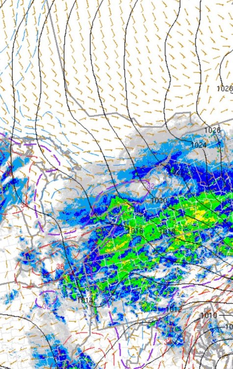
-
Upstate/Eastern New York
DeltaT13 replied to BuffaloWeather's topic in Upstate New York/Pennsylvania
I didn’t even have time to get my snowboards out in the yard yet as I’ve still been wrangling leaves. Guess I’ll just have to wing it when it’s comes to measurements. Speaking of leaves, the plows are going to be plowing huge piles of leaves all over tonight. It’s going to be a giant mess come tomorrow. Haha. -
Upstate/Eastern New York
DeltaT13 replied to BuffaloWeather's topic in Upstate New York/Pennsylvania
KROC just went over to sleet, son of a b**ch! -
Upstate/Eastern New York
DeltaT13 replied to BuffaloWeather's topic in Upstate New York/Pennsylvania
Yeah, I don't know why Dave said that or where he is exactly but its snowing like crazy and I havent heard a single "pinger" yet. -
Upstate/Eastern New York
DeltaT13 replied to BuffaloWeather's topic in Upstate New York/Pennsylvania
All snow at University of Rochester, actually fluffy flakes too. -
Upstate/Eastern New York
DeltaT13 replied to BuffaloWeather's topic in Upstate New York/Pennsylvania
Dansville now reporting light snow, dewpoint jumped to 25 from 18 in the last hour and temp dropped from 33 to 30. That's what we want to see -
Upstate/Eastern New York
DeltaT13 replied to BuffaloWeather's topic in Upstate New York/Pennsylvania
Dansville would appear entrenched in precip but the airport is reporting overcast. Dewpoint is still 18 with surface temp of 33. Still a ways to go in the G-valley before we are saturated. -
Upstate/Eastern New York
DeltaT13 replied to BuffaloWeather's topic in Upstate New York/Pennsylvania
The leading edge seems ahead of schedule relative to almost all the model outputs. Would love to see the roads good and greasy by 5pm. Love a messy commute! I've got the truck ready for some post work cruising if the snow is flying. As for this out, that seems reasonable as nearly 90 percent of the snow looks to be done by about 6am. Very quick wind down on the backside as the coastal starts deepening rapidly and gaining forward speed. This storm will start fast and end fast. -
Upstate/Eastern New York
DeltaT13 replied to BuffaloWeather's topic in Upstate New York/Pennsylvania
Seriously?, I always feel pretty even keeled compared to others around here....... This storm is a close call for us. My numbers are mostly in line with the forecasts and things are trending East a bit. We need that surface low to redevelop and hang around in NJ which is a gamble, it could develop 100 miles East and in that case WNY is in trouble. More important is the snow type. I think the ratios will be crazy low with this storm so even if we get a lot of precip, it just won't stack up very high. Super dense, grainy, gritty stuff. 3 inches sounds fantastic to me to be honest. Just give me something to snowblow and drive around in tonight. Not expecting a blockbuster at all. -
Upstate/Eastern New York
DeltaT13 replied to BuffaloWeather's topic in Upstate New York/Pennsylvania
Tough system for sure for us Western folks. Any snow that does fall will be quite heavy and dense with the crappy dendritic growth so even 3 inches will warrant a quick pass with the snowblower. While this isnt a great system, it's still a very early start to the season. Buf - 2" ROC - 3" Syr - 6" Bristol Hills - 7" -
Upstate/Eastern New York
DeltaT13 replied to BuffaloWeather's topic in Upstate New York/Pennsylvania
I can't believe they didnt include Niagara for continuity sake. Thats just being petty now, lol. -
Upstate/Eastern New York
DeltaT13 replied to BuffaloWeather's topic in Upstate New York/Pennsylvania
All of the model outputs that are being posted need to be cut in half or even 1/3 if past experience is any indication of the future. 2-4 seems reasonable area wide. -
Upstate/Eastern New York
DeltaT13 replied to BuffaloWeather's topic in Upstate New York/Pennsylvania
Suns out and things are winding down. Looks like we got just a touch over an inch, very fluffy stuff too. Over performer for what I expected to be honest, haha. Now to get ready for the first synoptic event! -
Upstate/Eastern New York
DeltaT13 replied to BuffaloWeather's topic in Upstate New York/Pennsylvania
KROC getting some love right now. We might end up with an inch if this last band can hold together for another hour. It looks glorious out there!! -
Upstate/Eastern New York
DeltaT13 replied to BuffaloWeather's topic in Upstate New York/Pennsylvania
And thats exactly what they should do. Gone are the days when they put out a forecast twice a day and rode it regardless of what happens. Nowcast Nowcast Nowcast. The internet is a great medium! -
Upstate/Eastern New York
DeltaT13 replied to BuffaloWeather's topic in Upstate New York/Pennsylvania
So you would rather them continue to run a bad forecast rather than update it? I love the fact that they are continually updating these forecasts as new data is digested into the models. You guys have way too high of standards when it comes to the NWS. They are guys just like us with virtually the same data doing the best they can. I hope they update their forecasts every minute to keep things as fresh as possible.