DeltaT13
-
Posts
3,006 -
Joined
-
Last visited
Content Type
Profiles
Blogs
Forums
American Weather
Media Demo
Store
Gallery
Everything posted by DeltaT13
-
Upstate/Eastern New York
DeltaT13 replied to BuffaloWeather's topic in Upstate New York/Pennsylvania
I'm home from work, less stressed, and fed. Of course the GFS continues to lure me like a carrot on a stick, haha,. This 0z run tonight will be very significant.. -
Upstate/Eastern New York
DeltaT13 replied to BuffaloWeather's topic in Upstate New York/Pennsylvania
OUCH!!!
-
Upstate/Eastern New York
DeltaT13 replied to BuffaloWeather's topic in Upstate New York/Pennsylvania
Officially losing steam on this one, I guess thats what happens when you track from 240 hours out, haha (We all know better too). We'll get some front end snow and some lake enhancement. It'll be wintry for a couple days, just not a blockbuster. Thus is life. Looking further out I see some hints a big warmup to start February, that has me more depressed than anything. -
Upstate/Eastern New York
DeltaT13 replied to BuffaloWeather's topic in Upstate New York/Pennsylvania
Buffalo already posting watches. “That’s a bold move cotton, let’s see if it pays off.” -
Upstate/Eastern New York
DeltaT13 replied to BuffaloWeather's topic in Upstate New York/Pennsylvania
Very bad. Coastal transfers are the bane of WNY snow lovers existence. -
Upstate/Eastern New York
DeltaT13 replied to BuffaloWeather's topic in Upstate New York/Pennsylvania
Get out of here with that nonsense. We don't need sun during January and February "aint nobody got time for dat" All you closet summer lovers make me sick - (i'm looking in your direction Buffaloweather) -
Upstate/Eastern New York
DeltaT13 replied to BuffaloWeather's topic in Upstate New York/Pennsylvania
Looks like a lot of bone dry anticyclonic air to me. Just crushing inversions and no moisture to work with. Right behind these systems will get a little blast but nothing sustained. -
Upstate/Eastern New York
DeltaT13 replied to BuffaloWeather's topic in Upstate New York/Pennsylvania
It certainly does and it has slowed down by a good 12 hours or so. It's a pretty big outlier at this point though so I can't cherry pick that model. -
Upstate/Eastern New York
DeltaT13 replied to BuffaloWeather's topic in Upstate New York/Pennsylvania
With the current trend that actually seems pretty plausible and not the worst. 6 would be disappointing, 12 would be fine. -
Upstate/Eastern New York
DeltaT13 replied to BuffaloWeather's topic in Upstate New York/Pennsylvania
Well I can breathe for another 6 hours. It sounds like a cheesy excuse but that 0z run really did seem to have some convective feedback issues. I'm a nervous wreck with this storm. -
Upstate/Eastern New York
DeltaT13 replied to BuffaloWeather's topic in Upstate New York/Pennsylvania
Great minds think alike B-lo Bumble! -
Upstate/Eastern New York
DeltaT13 replied to BuffaloWeather's topic in Upstate New York/Pennsylvania
Hey wait, I know what to blame... convective feedback, hahaha. Joking aside, that secondary surface low does pop in the deep convection south of the parent storm stringing out the system and weakening the system as a whole. Hopefully it will correct away from that. -
Upstate/Eastern New York
DeltaT13 replied to BuffaloWeather's topic in Upstate New York/Pennsylvania
Well kids, I've seen enough for tonight, off to bed. This is the gut punch I've been expecting. I'm certainly not giving up but that run is a bit of a crusher. -
Upstate/Eastern New York
DeltaT13 replied to BuffaloWeather's topic in Upstate New York/Pennsylvania
Jesus, the GFS is going all Ukie on us. oh man...there it is. There are tricks up this storms sleeve -
Upstate/Eastern New York
DeltaT13 replied to BuffaloWeather's topic in Upstate New York/Pennsylvania
Yeah, its a much more elongated low pressure center, less organized. This might help slow that NW trend but I'd still like to see a sub 1000mb system coming out of the Ohio valley. We need a happy medium here. -
Upstate/Eastern New York
DeltaT13 replied to BuffaloWeather's topic in Upstate New York/Pennsylvania
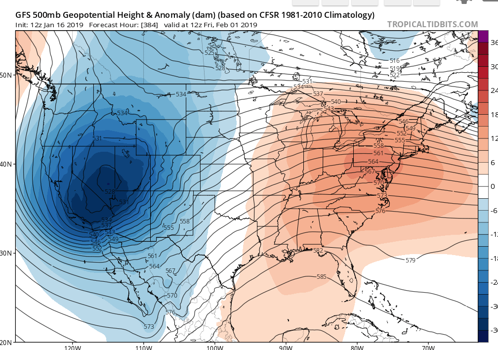
I actually think the plains blizzard warnings are way more obnoxious/overused even though they technically meet the criteria. Plains storms seem so damn lame most of the time. Boston has gotten bigger synoptic storms than we have for the most part plus they have a gigantic sprawling disastrous road network. But yeah, **** Boston...they are pansies sometimes. -
Upstate/Eastern New York
DeltaT13 replied to BuffaloWeather's topic in Upstate New York/Pennsylvania
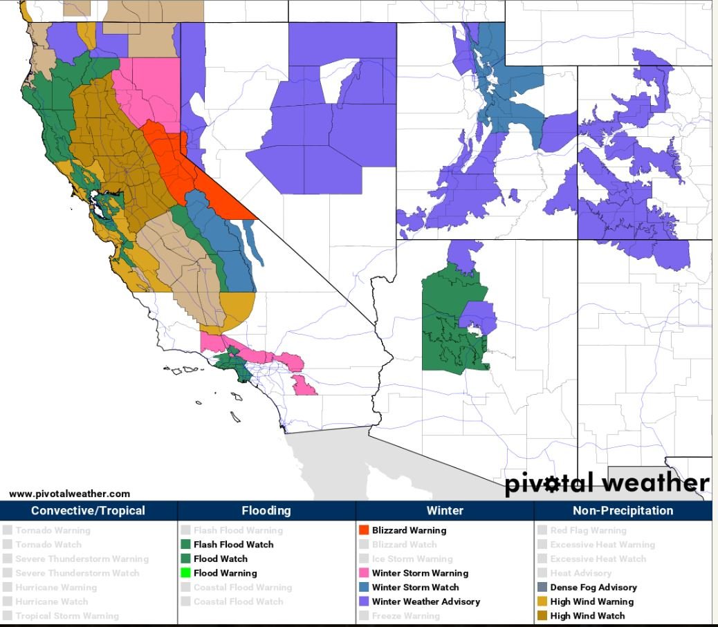
Would be an incredible experience for sure, especially with 80-100mph winds. The sierras get rocked routinely but this storm seems more like a every 2 or 3 year type of event. Maybe more. I havent seen a warning map like this in Cali in for awhile.
-
Upstate/Eastern New York
DeltaT13 replied to BuffaloWeather's topic in Upstate New York/Pennsylvania
There is still a blizzard warning. It just goes straight from Winter Storm Watch to Blizzard warning now. -
Upstate/Eastern New York
DeltaT13 replied to BuffaloWeather's topic in Upstate New York/Pennsylvania
As a quick side note, anyone looking at what our storm is doing when it hits Cali? That is some insane shit right there. This peak south of Tahoe is forecasting 85-113 inches over a 3 day period. Daaaamnnnnn This Afternoon Snow. Steady temperature around 22. South wind around 14 mph, with gusts as high as 21 mph. Chance of precipitation is 100%. Total daytime snow accumulation of 6 to 10 inches possible. Tonight Snow. Temperature rising to around 27 by 5am. Windy, with a southwest wind 28 to 32 mph, with gusts as high as 48 mph. Chance of precipitation is 90%. New snow accumulation of 10 to 14 inches possible. Wednesday Snow. High near 31. Windy, with a south southwest wind around 31 mph, with gusts as high as 47 mph. Chance of precipitation is 90%. New snow accumulation of 6 to 10 inches possible. Wednesday Night Snow showers. The snow could be heavy at times. Low around 25. Windy, with a south southwest wind 39 to 44 mph increasing to 45 to 50 mph after midnight. Winds could gust as high as 80 mph. Chance of precipitation is 100%. New snow accumulation of 31 to 37 inches possible. Thursday Snow showers. The snow could be heavy at times. High near 29. Windy, with a southwest wind around 47 mph, with gusts as high as 70 mph. Chance of precipitation is 100%. New snow accumulation of 26 to 32 inches possible. Thursday Night Snow showers. Low around 15. Windy. Chance of precipitation is 100%. New snow accumulation of 6 to 10 inches possible. -
Upstate/Eastern New York
DeltaT13 replied to BuffaloWeather's topic in Upstate New York/Pennsylvania
That 18z run has a mix well into the fingerlake and we know that the mix line usually exceeds the models by 25 miles or so. Getting a little too close for comfort IMO. -
Upstate/Eastern New York
DeltaT13 replied to BuffaloWeather's topic in Upstate New York/Pennsylvania
Yeah, I guess my fear is that a deeper initial low will be a touch slower and perhaps better aligned for a full phase. In that scenario I think it moves more north northeast as it pushes the warm sector and baroclinic zone further north. It certainly is running into a formidable arctic high so we have that going for us. The slightly strung out partial phase is probably a safer bet though. -
Upstate/Eastern New York
DeltaT13 replied to BuffaloWeather's topic in Upstate New York/Pennsylvania
The last 4 runs of the Euro have all dropped 1mb with each run during the development stage near Missouri. These runs are also a little more amped. I'm nervous it just keeps ticking NW. The southern Tier towards Bing is already getting into a mixed precip scenario with a setup like that. -
Upstate/Eastern New York
DeltaT13 replied to BuffaloWeather's topic in Upstate New York/Pennsylvania
Thursday PM AFD is my guess. -
Upstate/Eastern New York
DeltaT13 replied to BuffaloWeather's topic in Upstate New York/Pennsylvania
I'm going to feel a hell of a lot more confident once the parent storm is on-shore. Still another 36 hours before that happens. Things will really lock in late tomorrow and Early Thursday. Until, then hold on tight. -
Upstate/Eastern New York
DeltaT13 replied to BuffaloWeather's topic in Upstate New York/Pennsylvania
That avatar is a sight for sore eyes! Jump on in, the water is perfect!