

DeltaT13
-
Posts
3,006 -
Joined
-
Last visited
Content Type
Profiles
Blogs
Forums
American Weather
Media Demo
Store
Gallery
Everything posted by DeltaT13
-
Upstate/Eastern New York
DeltaT13 replied to BuffaloWeather's topic in Upstate New York/Pennsylvania
Surface low definitely looks further West than the models had it. Also moving slow. Lot of moisture still coming back this way. I've heard reports of nearly two feet in Vermont and they've been getting smoked all night. Getting shadowed here at the moment.... hoping that changes as winds shift. On a side note, the winds are absolutely crazy here, even in the valley. This old motel is shaking, creaking, cracking....pretty wild. Definitely expecting wind holds tomorrow morning on the lifts and gondy. I guess thats what a sub 980 low will do, this thing really deepened quickly.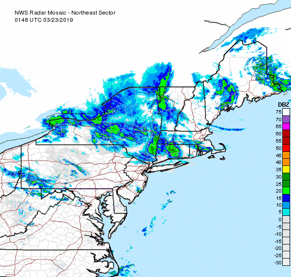
-
Upstate/Eastern New York
DeltaT13 replied to BuffaloWeather's topic in Upstate New York/Pennsylvania
Made it up to the base of whiteface in record time. Decided to take 87 to avoid that typically treacherous route 3. Wet roads and rain most of the drive. Never got lower than 34 degrees. Quite shocked to be honest. Looks like the base area got a few inches. I see the whiteface website says they got 9 today so hopefully it’s a different world higher up the mountain. A very strange storm indeed. -
Upstate/Eastern New York
DeltaT13 replied to BuffaloWeather's topic in Upstate New York/Pennsylvania
Leaving at 3pm. I just saw that whiteface already got 5 inches so that makes me a feel quite a bit better. -
Upstate/Eastern New York
DeltaT13 replied to BuffaloWeather's topic in Upstate New York/Pennsylvania
For this storm to really produce we needed that low to stall over the gulf of Maine for 18-24 hours which is what it did on the models all week. Starting at the 18z runs yesterday things just got a lot more progressive and it basically just speeds out to sea. My 18-24" dreams have been reduced to praying for 3-6. Oh well, I shall make the best of it. I don't have the heart to tell my buddies its going to be a bust......They are going to hate me. -
Upstate/Eastern New York
DeltaT13 replied to BuffaloWeather's topic in Upstate New York/Pennsylvania
Wish this hotel room was refundable..... Gonna be a lot of time, driving and money for 5 inches of snow. What a bust.... -
Upstate/Eastern New York
DeltaT13 replied to BuffaloWeather's topic in Upstate New York/Pennsylvania
The models no longer loop, stall, and redevelop the surface low back over Maine, that cuts down on a solid 12 hours of precip. I think that explains the the 50% drop in max totals. Not the look I wanted but it actually looks more plausible. I'll be staying up to watch the 'cuse game and watch the models roll in. If we get 8 inches or more at Whiteface I'll call it a win. Setting the bar relatively low. -
Upstate/Eastern New York
DeltaT13 replied to BuffaloWeather's topic in Upstate New York/Pennsylvania
I really hope youre right. Half my crew is banking on VT, me and few others decided on whiteface. All you really need is about 6-8 inches and it'll be a great POW day. Anything extra is just gravy! -
Upstate/Eastern New York
DeltaT13 replied to BuffaloWeather's topic in Upstate New York/Pennsylvania
Yeah, would be nice to get a good start to the day without any lift issues. Maybe the winds won't pick up until noon or so. Any clearing will really mix them down too. -
Upstate/Eastern New York
DeltaT13 replied to BuffaloWeather's topic in Upstate New York/Pennsylvania
Both days should be top notch. I like the deep ungroomed stuff so Saturday will hopefully be a the real deal for me. Sunday will be a bluebird spring day though, no doubt about that. A little worried about wind holds on some of the lifts on Saturday though. -
Upstate/Eastern New York
DeltaT13 replied to BuffaloWeather's topic in Upstate New York/Pennsylvania
Yeah, I have some leftover passes to use and they do well in these type of upslope events where the low stalls and pinwheels for a day. Northern Vermont will do very well too but that drive is rough. My asshole friends are going to mad River so that means I'm out for that too (No Snowboarding allowed) That said, some models have been hinting at a more progressive low track so I'm a little nervous committing to this plan. I need this thing to really get hung up to cash in. -
Upstate/Eastern New York
DeltaT13 replied to BuffaloWeather's topic in Upstate New York/Pennsylvania
I booked a room in the 'Dacks for one last good day on the slopes. Couldnt stand the thought of sitting this one out. Snow ratios look good overnight friday so I'm hoping for some quality POW on Saturday. -
Upstate/Eastern New York
DeltaT13 replied to BuffaloWeather's topic in Upstate New York/Pennsylvania
It's painful that we finally start locking in some blocking and prolonged cold........in the Middle March. I'm officially over it, and much sooner than most years. grrrr -
Upstate/Eastern New York
DeltaT13 replied to BuffaloWeather's topic in Upstate New York/Pennsylvania
Don't forget the Bills will go to the Superbowl and the Sabres might make the playoffs! -
Upstate/Eastern New York
DeltaT13 replied to BuffaloWeather's topic in Upstate New York/Pennsylvania
haha, damn man, You're really holding out hope. I think I'm taking the snowtires off this weekend, long range looks wet and mild for the most part. Game Set Match. -
Upstate/Eastern New York
DeltaT13 replied to BuffaloWeather's topic in Upstate New York/Pennsylvania
The only SAD setting in is legit sadness because the damn winter is already over. It just never felt like winter for any prolonged time. And here we are heading into spring and I never really scratched my winter itch. -
Upstate/Eastern New York
DeltaT13 replied to BuffaloWeather's topic in Upstate New York/Pennsylvania
That's the weirdest map of the whole season. Hands down. Dansville 3" Batavia 4" Is that little shortwave going to pop synotic snow? It looked really moisture starved on every run. -
Upstate/Eastern New York
DeltaT13 replied to BuffaloWeather's topic in Upstate New York/Pennsylvania
BW, You going to Holiday Valley this weekend for the Winter Carnival? Saturday looks absolutely perfect and likely one of the last good days of the whole season as we get drenched all day sunday and the snowpack will once again be wrecked by ice and slop. I'm hoping to spend a solid 8 hours there. -
Upstate/Eastern New York
DeltaT13 replied to BuffaloWeather's topic in Upstate New York/Pennsylvania
Is it just me or do these maps seem INSANELY optimistic?? I mean I could see some localized slivers SE of Ontario picking up a foot, but holy crap do they make this look really widespread. I seriously think 90 percent of that map sees 2 inches or less. Im almost speechless by how aggressive that forecast is, like what the hell am I missing? -
Upstate/Eastern New York
DeltaT13 replied to BuffaloWeather's topic in Upstate New York/Pennsylvania
I just got back from Stratton this weekend. All things considered it was a pretty good trip. Snow was decent with some blue bird days. I may hit Bristol one night this week but the brutal cold isnt making it all that appealing, if you go I'll be interested to hear how the conditions are.. Probably going to Holiday Valley this weekend for the "Winter" carnival (I have no idea why they have the winter carnival in March, its ass backwards). Anyway, Saturday looks pretty perfect, low 30's and sun with no wind. Hoping to make a whole day out of it. After that, looks like the ski season is just about dunzo with more rain on the horizon and warmer temps by mid month. An average year at best.... -
Upstate/Eastern New York
DeltaT13 replied to BuffaloWeather's topic in Upstate New York/Pennsylvania
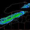
I measured about 5 inches when all was said and done here. The banding during the last few hours made up for a lot lost time with poor accumulation rates earlier in the day. A decent little storm. It took me 55 minutes to get drive 6 miles. Normally takes about 10 mins. -
Upstate/Eastern New York
DeltaT13 replied to BuffaloWeather's topic in Upstate New York/Pennsylvania
This article says 7 were seen near grand island, and holy smokes is that a lot of ice! I would have to assume the whole thing failed fairly catastrophically. https://www.wgrz.com/article/news/local/ice-boom-in-lake-erie-breaks-due-to-winds/71-4962175a-d5b1-4e8c-bfc0-65db04a7544c -
Upstate/Eastern New York
DeltaT13 replied to BuffaloWeather's topic in Upstate New York/Pennsylvania
I would be pleasantly surprised. I'm holding out some hope that we might get some good gusts again once the winds are more NW and Lake Ontario can come into play. -
Upstate/Eastern New York
DeltaT13 replied to BuffaloWeather's topic in Upstate New York/Pennsylvania
Get some pics tomorrow if you can. Theres going to be crazy ice formations all over. Wonder how big a jam will form further downstream... -
Upstate/Eastern New York
DeltaT13 replied to BuffaloWeather's topic in Upstate New York/Pennsylvania
i think the only way you get 75mph gusts around here from a storm like this is through diurnal mixing. We needed that frontal passage to happen at 9am and then some clearing around noon with breaks of sun. It will still be awesomely windy overnight, but the loss of daylight and also the loss of Lake Erie funneling as winds veer means that the highest risk portion of the event is probably passed. -
Upstate/Eastern New York
DeltaT13 replied to BuffaloWeather's topic in Upstate New York/Pennsylvania
Shows over in regards to the damaging wind potential. One disappointed wind enthusiast here. Still will be a nice long night of roaring gusts though I'm back to tracking nuisance snow events that turn into rain again!

