DeltaT13
-
Posts
3,006 -
Joined
-
Last visited
Content Type
Profiles
Blogs
Forums
American Weather
Media Demo
Store
Gallery
Everything posted by DeltaT13
-
Upstate/Eastern New York
DeltaT13 replied to BuffaloWeather's topic in Upstate New York/Pennsylvania
I'll just be happy when I get my first frost/hard freeze later this week. Too many trees still holding leaves in my neighborhood. I want to get this lawn cleanup DONE already! -
Upstate/Eastern New York
DeltaT13 replied to BuffaloWeather's topic in Upstate New York/Pennsylvania
Actually just last year we had an abnormally wintry November too! It snowed 20 out of 30 days which is really quite a startling statistic. Rochester had 17 inches for the Month. December then went on to have above average temps and minimal snow, so these fast starts appear to come with risks. -
Upstate/Eastern New York
DeltaT13 replied to BuffaloWeather's topic in Upstate New York/Pennsylvania
This storm and the extremely strong pressure fall/rise couplet hit Montreal during the afternoon (Diurnal Max), that might be what took their winds to the next level. -
Upstate/Eastern New York
DeltaT13 replied to BuffaloWeather's topic in Upstate New York/Pennsylvania
That really is amazing. Even bullshit fantasy run storms aren’t usually that insane. I don’t think I’ve ever seen a sub 960mb storm cross the lakes -
Upstate/Eastern New York
DeltaT13 replied to BuffaloWeather's topic in Upstate New York/Pennsylvania
A quick side note as we move on from the wind storm. The GFS had that stormed pinned down to a T nearly 7 days out while the euro and cmc seemed to waffle a lot more leading up to it. Give credit where credit is due. -
Upstate/Eastern New York
DeltaT13 replied to BuffaloWeather's topic in Upstate New York/Pennsylvania
Well it didnt over perform, and it didnt bust. Pretty much did exactly what was forecast. Currently over 130 separate outages (~10,000 people) in the Rochester area so thats somewhat noteworthy. A fun little wind event for an enthusiast such as myself. I'll give it a 7 out of 10. Im sad to see it go though -
Upstate/Eastern New York
DeltaT13 replied to BuffaloWeather's topic in Upstate New York/Pennsylvania
It's definitely cold enough to be a sloppy graupelly mess. I would expect the heart of that band to be heavy wet snow. Surface temps will be marginal but elevated and grassy surfaces should accumulate. -
Upstate/Eastern New York
DeltaT13 replied to BuffaloWeather's topic in Upstate New York/Pennsylvania
Mesoscale forecast clearly shows one surface low to our NW. Not sure why the models are trying to create that other surface low to the E/NE. If this track hits it should be quite windy in the usual corridor NE of Lake Erie. -
Upstate/Eastern New York
DeltaT13 replied to BuffaloWeather's topic in Upstate New York/Pennsylvania
Yes, That is certainly possible. All of the truly damaging wind events almost always occur during daylight hours when diurnal mixing is maximized. Mixing is really the best way to get the strongest winds to the surface. That said, the nearly perfect timing of this storm hitting its peak deepening just as it passes to our NW may give us a boost of winds. I would say it has a higher chance of busting than verifying, but it certainly bears watching. It's always a little more exciting when no one is quite sure what to expect. -
Upstate/Eastern New York
DeltaT13 replied to BuffaloWeather's topic in Upstate New York/Pennsylvania
Its odd how the models want to place the primary surface low over Northern NY while a secondary and tighter surface low can be seen just SE of Lake Huron. Thats the low that will bring us the winds.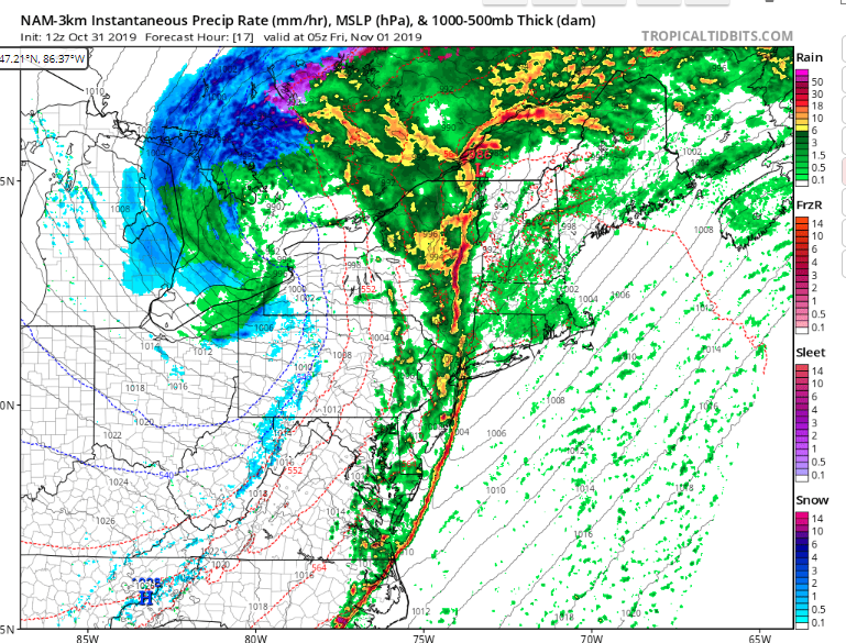
-
Upstate/Eastern New York
DeltaT13 replied to BuffaloWeather's topic in Upstate New York/Pennsylvania
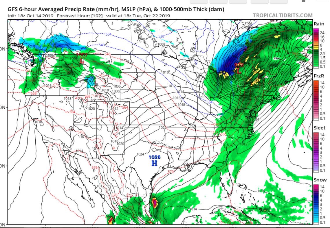
While not an typical setup, there are some intriguing things. The low is somewhat double barreled but the deeper stronger and more tightly packed surface low actually consolidates and remains West of us just over Southern Ontario. The storm is also hitting its peak deepening phase right as it crosses over the Eastern Lakes which is absolutely ideal. Couple that with a very nice isallobaric pressure rises and I think we can overcome the slightly unusual storm track. I'm cautiously optimistic this might overperform in my neck of the woods. Trees are still holding a lot of leaves which may make a big difference. -
Upstate/Eastern New York
DeltaT13 replied to BuffaloWeather's topic in Upstate New York/Pennsylvania
I haven’t even raked leaves one time yet. That will change drastically come tonight. Lol. I’m ready to get the cleanup underway! -
Upstate/Eastern New York
DeltaT13 replied to BuffaloWeather's topic in Upstate New York/Pennsylvania
That’s a very impressive stat. I really can’t recall an upstate location receiving that much synoptic rainfall in one month. -
Upstate/Eastern New York
DeltaT13 replied to BuffaloWeather's topic in Upstate New York/Pennsylvania
The power going out is the fun part! Thats what I'm sad about. haha -
Upstate/Eastern New York
DeltaT13 replied to BuffaloWeather's topic in Upstate New York/Pennsylvania
I'm sad to see this current storm slowly trending weaker and weaker. We went from a sub 980mb low to a 991mb low in the span of a couple days. Still a nice track though and there should be a nice window of decent winds just behind the actual front, but not the blockbuster I had been rooting for. -
Upstate/Eastern New York
DeltaT13 replied to BuffaloWeather's topic in Upstate New York/Pennsylvania
Rochester still hasnt hit freezing yet this fall so the growing season continues on. Pretty wild that I'm still picking peppers from the garden. We might not even hit it this weekend and if that happens looks like we'll go another 7 days before the next chance. -
Upstate/Eastern New York
DeltaT13 replied to BuffaloWeather's topic in Upstate New York/Pennsylvania
That Friday storm is still looking fierce and gaining quite a bit of support among numerous models. There would definitely be some damage from that storm track. It also ushers in the first flakes for most everyone. Almost in range to start believing it could happen. Also, the Bills game will be quite windy tomorrow. Should basically remove the kicking game and hinder the pass game. I hope Singletary and Gore can run a good ground game. -
Upstate/Eastern New York
DeltaT13 replied to BuffaloWeather's topic in Upstate New York/Pennsylvania
Haha, you know it. Thats a dream setup! -
Upstate/Eastern New York
DeltaT13 replied to BuffaloWeather's topic in Upstate New York/Pennsylvania
Transient bouts of early season cold do not seem to have any real impact on long term average lake temps. I'll take an early season teaser, its been awhile -
Upstate/Eastern New York
DeltaT13 replied to BuffaloWeather's topic in Upstate New York/Pennsylvania
End of the month is definitely trending quite cold with a decent elevation based lake response (snow) starting to show up on the GFS. Still way out but somewhat unusual to see in October even for fantasy land. Better get your snow tires on buffaloweather, we might be sending you on some chases sooner than normal!
-
Upstate/Eastern New York
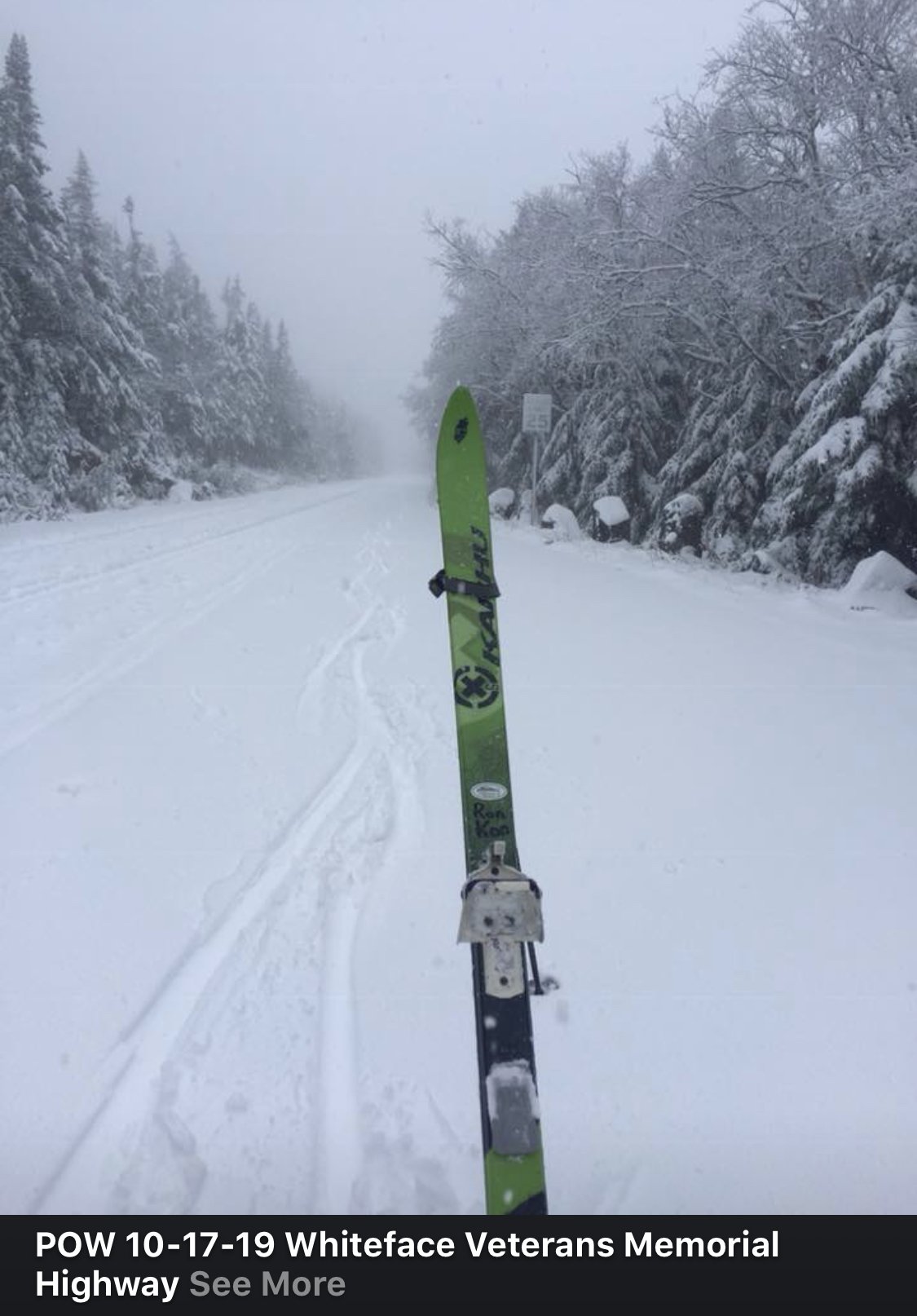
DeltaT13 replied to BuffaloWeather's topic in Upstate New York/Pennsylvania
This guy earned his turns today! 5” at the top of the whiteface access road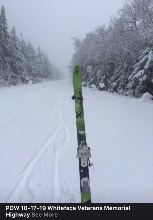
-
Upstate/Eastern New York
DeltaT13 replied to BuffaloWeather's topic in Upstate New York/Pennsylvania
Snowing hard in the high peaks of NY and Vermont this morning. Exciting stuff!! I'm ready -
Upstate/Eastern New York
DeltaT13 replied to BuffaloWeather's topic in Upstate New York/Pennsylvania
Add the cold biased NAM to a very powerful storm with a period of strong dynamic cooling and some models are hinting at a high peaks dump!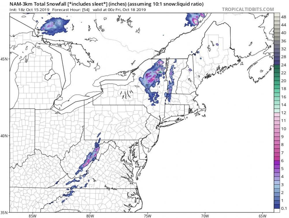
-
Upstate/Eastern New York
DeltaT13 replied to BuffaloWeather's topic in Upstate New York/Pennsylvania
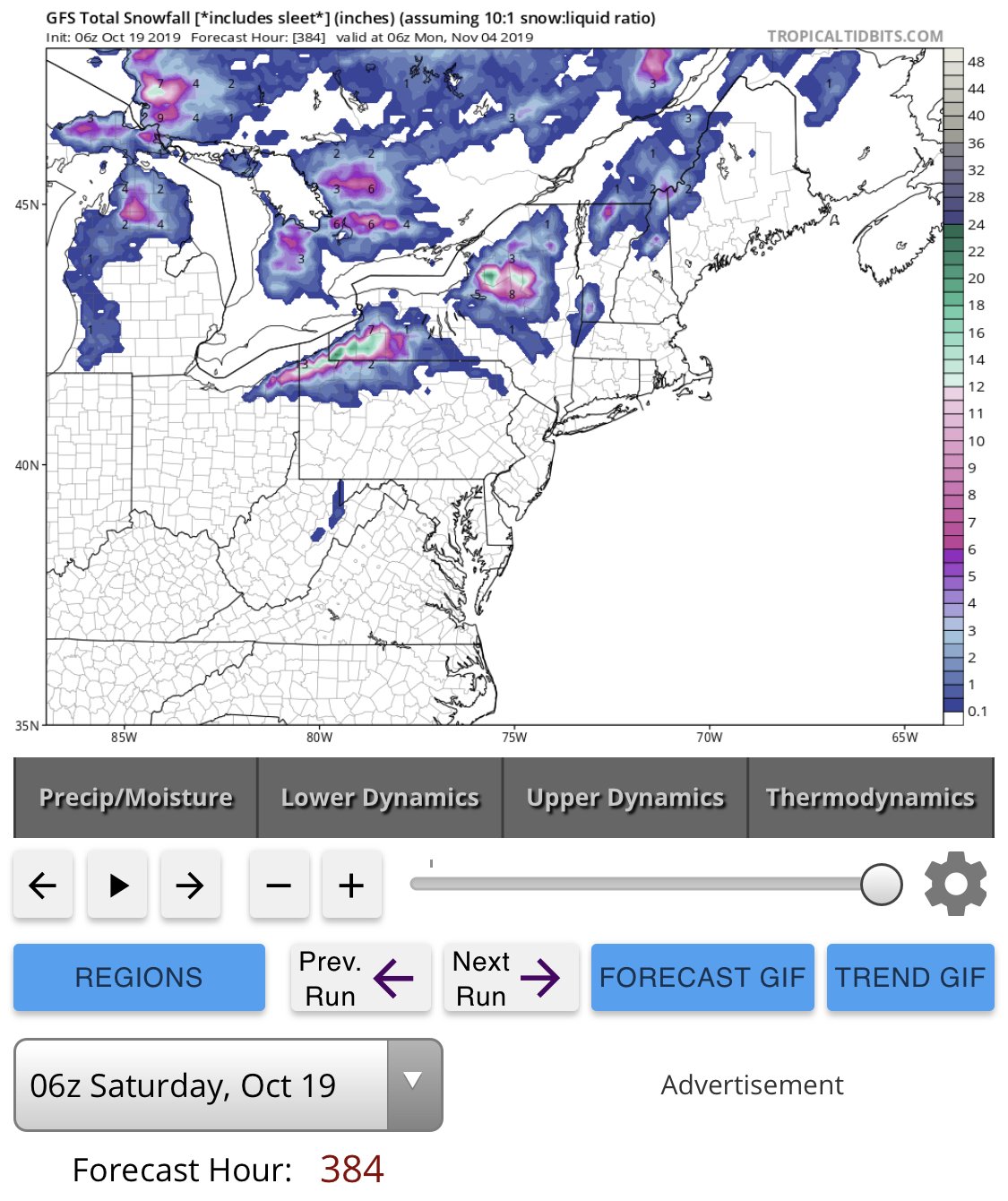
The storm lurking around day 7 absolutely goes off the charts every few runs. 18z today was no exception. If a track like that ever verified at this time of year there would be some extreme tree damage from winds. Just a textbook track.
-
Upstate/Eastern New York
DeltaT13 replied to BuffaloWeather's topic in Upstate New York/Pennsylvania
3 interesting storms on the horizon over the next 10 days and not a peep in here. Boooooooooo.