

DeltaT13
-
Posts
3,006 -
Joined
-
Last visited
Content Type
Profiles
Blogs
Forums
American Weather
Media Demo
Store
Gallery
Everything posted by DeltaT13
-
Upstate/Eastern New York
DeltaT13 replied to BuffaloWeather's topic in Upstate New York/Pennsylvania
Did you change over yet Dave? -
Upstate/Eastern New York
DeltaT13 replied to BuffaloWeather's topic in Upstate New York/Pennsylvania
Travel advisory in Livingston county. Kind of surprising as they are mostly the genny valley and usually change later and have less snow. -
Upstate/Eastern New York
DeltaT13 replied to BuffaloWeather's topic in Upstate New York/Pennsylvania
Very cool! Lewiston is below the escarpment, definitely not helping their case. -
Upstate/Eastern New York
DeltaT13 replied to BuffaloWeather's topic in Upstate New York/Pennsylvania
Sticking on the roads here. It’s now or never! Down to 34.5 -
Upstate/Eastern New York
DeltaT13 replied to BuffaloWeather's topic in Upstate New York/Pennsylvania
Down to 35 here. That’s a nice 3 Degree drop in an hour accumulation on grassy surfaces has commenced! -
Upstate/Eastern New York
DeltaT13 replied to BuffaloWeather's topic in Upstate New York/Pennsylvania
That’s not good man. A lot of models really showed that modified lake layer preventing change over along the lake shore until the bitter end -
Upstate/Eastern New York
DeltaT13 replied to BuffaloWeather's topic in Upstate New York/Pennsylvania
How close to the lake are you? Hopefully that doesn’t screw you. -
Upstate/Eastern New York
DeltaT13 replied to BuffaloWeather's topic in Upstate New York/Pennsylvania
Full on snow here now. Temp down to 36. -
Upstate/Eastern New York
DeltaT13 replied to BuffaloWeather's topic in Upstate New York/Pennsylvania
We really need the sun to set. That will buy us 2-3 more degrees in air temp but more importantly it will allow the pavement to cool off nicely -
Upstate/Eastern New York
DeltaT13 replied to BuffaloWeather's topic in Upstate New York/Pennsylvania
Backyard temp is 38.1 and big sloppy snowflakes just started mixing. -
Upstate/Eastern New York
DeltaT13 replied to BuffaloWeather's topic in Upstate New York/Pennsylvania
Take a close look at the 0z high res nam, it pops a surface low in deep convection off the east coast which rides up towards boston before backbuilding and jumping back over PA where the strongest upper level support is developing. I think the drop in precip on that 0z NAM run might be related to convective feedback,(however sometimes the surface low really will track with that deep convection) where the 18z run maintains the primary low over PA. Anyway something to keep an eye on. -
Upstate/Eastern New York
DeltaT13 replied to BuffaloWeather's topic in Upstate New York/Pennsylvania
I'm fascinated by the prospect of a rapidly deepening sub 980mb low over the adirondacks. That really doesnt happen often at all. Certainly not a classic high wind track but its got to end up producing some pretty damn gusty winds on the South shore of Lake Ontario. Combine that wind with some concrete like snow and we might even have some branches down and power outages. Also wondering if they will extend those lakeshore flood watches. The water levels are so high -
Upstate/Eastern New York
DeltaT13 replied to BuffaloWeather's topic in Upstate New York/Pennsylvania
WWA for Roc! The situation continues to evolve -
Upstate/Eastern New York
DeltaT13 replied to BuffaloWeather's topic in Upstate New York/Pennsylvania
3 or 4 inches in ROC would be a huge win in my book. This is a tough setup and ratios will be like 8:1 so that’s still a lot of precip. Tempering my expectations because riding the NAM is a dangerous game. -
Upstate/Eastern New York
DeltaT13 replied to BuffaloWeather's topic in Upstate New York/Pennsylvania
I mean it certainly doesnt hurt us. The models have always forecasted it to be deep, but it over the last two days the sfc low min pressure has decreased by almost 15mb which is certainly significant. That can only help wrap in the cold air faster. I'm also rusty on adiabatic/diabatic cooling processes but I seem to remember additional cooling under rapidly deepening storms as the heights begin to crash. -
Upstate/Eastern New York
DeltaT13 replied to BuffaloWeather's topic in Upstate New York/Pennsylvania
Regardless of precip type, that storm tomorrow is anomalously deep. Most models have it bottoming out in the low 970's or even upper 960's as it moves into Quebec, that's fairly unusual. -
Upstate/Eastern New York
DeltaT13 replied to BuffaloWeather's topic in Upstate New York/Pennsylvania
But I do agree, this storm isnt magically changing into a snow storm in two days. But I think there could be some surprises further west with elevation involved -
Upstate/Eastern New York
DeltaT13 replied to BuffaloWeather's topic in Upstate New York/Pennsylvania
Well I wouldnt quite go that far. The 540dm line is trudging through WNY on the tail end of this so marginally cold enough air isnt that far away. Add some dynamic cooling from heavy precip, diurnal cooling, and elevation, and I would be surprised to see someone get 3-5 out of it. Definitely not ideal by any stretch but we miss out on a sloppy wet snow event by a couple degrees. Of course the cold biased NAM is showing the most optimistic of scenarios. Areas in SW NY are obviously in the best spot. CNY is a washout. -
Upstate/Eastern New York
DeltaT13 replied to BuffaloWeather's topic in Upstate New York/Pennsylvania
Damn, as you obviously know that street ends (or starts) at doebler drive. Pretty crazy, my brother graduated in 94 so you may have known him. -
Upstate/Eastern New York
DeltaT13 replied to BuffaloWeather's topic in Upstate New York/Pennsylvania
Spent the first 18 years of my life on Doebler Drive. It was a very nice town to grow up in, aside from the lack of lake effect snow, lol. -
Upstate/Eastern New York
DeltaT13 replied to BuffaloWeather's topic in Upstate New York/Pennsylvania
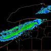
This band is certainly creating strong wind gusts along its perimeter. Even as the scraggly end has edged towards my location in Rochester the winds have ramped up significantly, its very impressive. Lot of vertical motion in that thing. -
Upstate/Eastern New York
DeltaT13 replied to BuffaloWeather's topic in Upstate New York/Pennsylvania
Amen, I grew up in North Tonawanda. It was brutal always being just a handful of miles away from pure insanity. The Christmas week storm from 2001 was particularly rough to watch from the side lines (and we even got 2 feet or so, just nowhere near what Buffalo got). Fortunately, for most people thats a huge selling point to living in the North Towns, most people hate snow. -
Upstate/Eastern New York
DeltaT13 replied to BuffaloWeather's topic in Upstate New York/Pennsylvania
Did you see the radar I posted? It’s gaining fetch and strength right now. Give it an hour. -
Upstate/Eastern New York
DeltaT13 replied to BuffaloWeather's topic in Upstate New York/Pennsylvania
Looks like additional moisture and a wind shift on the west end of Erie, it’s really blossoming. This band will be on the move again soon. -
Upstate/Eastern New York
DeltaT13 replied to BuffaloWeather's topic in Upstate New York/Pennsylvania
Damnit all, that band is most certainly chase-able. I blew it again. What a beast!!
