

Typhoon Tip
-
Posts
43,388 -
Joined
-
Last visited
Content Type
Profiles
Blogs
Forums
American Weather
Media Demo
Store
Gallery
Everything posted by Typhoon Tip
-
Wake Me Up When September Ends..Obs/Diso
Typhoon Tip replied to 40/70 Benchmark's topic in New England
I tell you ...what I would give to just once see this Icelandic Low park 50 mi SW of Chatham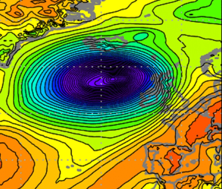
-
Wake Me Up When September Ends..Obs/Diso
Typhoon Tip replied to 40/70 Benchmark's topic in New England
"dud" can be sub-categorized by observation, too... Like, these individual tree species did always tend to favor different times. Some earlier along the ~ 3 week 'color season' while others, like Oak and Silver Maple were very late. It seems that is spread out even more now, such that particular species are getting to a 5-day span of pop more like solo acts. So instead of that one big week of technicolor explosions, fireworks crescendo at the end of the autumn show ...we're getting these small detonations at different times along a color season that's more like 4 or 5 weeks in length that just sort of fades out to a piece of shit brown ground winter ... I digress. The other aspect is disease. I've seen this sort of "blight" like Septiforia fungus other years since 2010. One year, the 90 year old sugar maple at the corner of my plat up and browned and downed by September 15. Zero color, just death. One year, ...tho the tree always turned a vibrant saffron that lit up the neighborhood with orange light during late October afternoons, it turn yellow by the end of September. Like banana yellow, and the individual leaves had dark spots. I did not live here prior to 10 years ago, but the first 4 years I did so, that tree was very consistently orange max on or about October 10. It's been rather unpredictable and more dullard ever since. -
Wake Me Up When September Ends..Obs/Diso
Typhoon Tip replied to 40/70 Benchmark's topic in New England
This actually happened back in like 2018 or 2019 at my way one of those years -
Wake Me Up When September Ends..Obs/Diso
Typhoon Tip replied to 40/70 Benchmark's topic in New England
That’s what this is! I thought my lilacs all just up and died. All their leaves turn brown in their skeletal now. Just about out of nowhere. Never seen that before. That blurb specifically speaks of ‘yard trees’, and so forth, which lilacs certainly qualify. The leaf discoloration is the exact same pattern as those photographs. -
Good conversation ... ... I think some on both sides could stand to add a spice of 'relativity'. Just a suggestion. Not judging. Not pointing fingers. In fact, I'm not sure who all said what ... I was reading quickly thru the posts.
-
How exactly does a denser number of reporting stations make it warmer? It's odd that any Joe would "comprehend" more reporting stations as causing higher readings, when that statement does zero refutation to the idea that more reporting stations could also make colder - if/when and fairly going by that same [faux] logic.
-
Wake Me Up When September Ends..Obs/Diso
Typhoon Tip replied to 40/70 Benchmark's topic in New England
Is it really on schedule? Oh, it's been torrid up to this point, but ironically an autumn reminiscent cool shot ( ahead of a TC no less, ha!), on or about the 15th of September seems pretty typical for me. The models have been hinting at a ridge in the east with maybe two or three days of positives ... D7+ ... haven't seen the 12z's yet -
Not up to speed on what/if any other's have commented on but Lee looks very extra-tropical on Sat already... In fact, I commented on the busted open core last night - I'm will to suspect that the conversion had already begun as of latter yesterday (speculation pending phase analysis - )
-
It reminds me … something strange took place with the QBO around then, too. Strong easterly(westerly) phase abruptly broke down, an interruption whence there was a win reversal, before the previous dynamic resumed. I think it or a similar observation in recent times were never before observed. Interesting
-
Lee’s core is entirely exposed no deep convection really. this may be a tropical storm by 40N. this thing has been acting like it’s been over marginal heat content about 3 days now. I wonder if it fell victim to its own upwelling
-
Really is the silent remarkable aspect about the storm… I mean really, the GFS storm track being within 500 miles of actual both disheartening as it is awe inspiring … doing so from day 10 when using the mean of all of its runs.
-
Man that was a nutty shift to the west of the GFS
-
Wake Me Up When September Ends..Obs/Diso
Typhoon Tip replied to 40/70 Benchmark's topic in New England
One aspect I like about autumn ... particularly going past the Met mid point, is the tracking the first snowfall. You may even get a couple of shots at it ... A flurry from a busted virga cu doesn't really count in this - although, that air mass is kind of romantic if someone's wood stove is adding sentiment. You sometimes get the obvious chance, but you might also get those cold cat paw rains that 'smell' like snow? All the while, if they fail, you got like 4 months of retries so no sweat. Although I do start to tune out by mid February if and when the winter's are long and unproductive. -
00z NAM slams it into the coast. Lol
-
Wake Me Up When September Ends..Obs/Diso
Typhoon Tip replied to 40/70 Benchmark's topic in New England
I’m not sure the dews won’t creep back tho. I mean it may not be in the 70s again but we’re gonna be getting dewpoint in the mid 60s that’s not very September like either. …yesterday felt drier than it was just cause we’ve been so saturated for so long. I expect more in the same …thinking it’s drier than it really is. -
Wake Me Up When September Ends..Obs/Diso
Typhoon Tip replied to 40/70 Benchmark's topic in New England
It was both uninspired for observation, oddly at the same time it was extraordinary …in a few different ways. -
Wake Me Up When September Ends..Obs/Diso
Typhoon Tip replied to 40/70 Benchmark's topic in New England
time to deflate I suppose. Not sure what to call that pattern going forward but it looks devoid of anything that captures attention … Like placidity perhaps the way September is supposed be. Still, going from these last two weeks of Heat Floods Tors and a Charlie Brown tropical cyclone, into that modeled abyss of nothingness may take a methadone lockdown -
Nothing like goin from a Charlie Browner event …squarely into a complete emptiness of any reason to engage Kind of like losing the Super Bowl when your hockey and hoops teams are in dead last
-
Seems like you guys are chasing the end of an unmanned firehose as its flopping around from one run to the next
-
I'm thinking this snark is actually valid/plausible throughout everywhere, actually ( not speaking to shore communities here...) Not sure I see how BL resistance is overcome unless the core of this thing gets a lot closer. Wind is tricky though. We've seen phenomenal sounding looks for mid latitude wind potentials fall short in the passed with head scratches. Other times there's been over-achievement. It's hard to ignore a 973 MB back NW -I'll give a nod there. But still, it is in fact weakening while that is happening, and as the wind increases it will back due to BL resistance and then you have shear in the vertical cross section and big wind is above that planar rotation, while there is positive stability below..
-
Yeah, it seems like there’s a tendency to black-and-white this thing… That’s not what is meant by compensating forces. It’s not all or nothing.
-
I almost think it was better back in the 2005 to 2010 range… Then it became the “NAM” and it really kind of slip backWard.
-
Yeah, I wouldn’t compare winter phenomenon with anything that’s barotropic i.e. the tropics. The Nam has a NW bias with cyclone tracks and genesis along baroclinic axes, i.e. the temperature gradient between the Delmarva and southeast Massachusetts. It’s always on the northwest side of that thermal interface. A tropical entity moving north, and then interacting with the westerlies … it is a completely different animal.
-
Wake Me Up When September Ends..Obs/Diso
Typhoon Tip replied to 40/70 Benchmark's topic in New England
What I noticed down here is that at 81/66… by typical standards that would be considered a humid day, but it actually felt dry. I think it’s because we’ve been so punished by the sultry dewpoints for so long. -
Every model… every single one of them has at one time or another depicted this thing coming in from the south south east into southern New England up thru coastal Maine. none have been able to sustain that depiction across subsequent runs


