stormtracker
-
Posts
64,400 -
Joined
-
Last visited
Content Type
Profiles
Blogs
Forums
American Weather
Media Demo
Store
Gallery
Everything posted by stormtracker
-

Jan/Early Feb Medium/Long Range Discussion Part 3
stormtracker replied to WinterWxLuvr's topic in Mid Atlantic
this somehow didnt work out like i planned. -
Jan/Early Feb Medium/Long Range Discussion Part 3
stormtracker replied to WinterWxLuvr's topic in Mid Atlantic
I'll be sleep with the Euro destroys us. Imma wake up to like 8 more pages of this thread. Have fun yall -
Jan/Early Feb Medium/Long Range Discussion Part 3
stormtracker replied to WinterWxLuvr's topic in Mid Atlantic
The WinterWxStomtrackerMan storm -
Jan/Early Feb Medium/Long Range Discussion Part 3
stormtracker replied to WinterWxLuvr's topic in Mid Atlantic
-
Jan/Early Feb Medium/Long Range Discussion Part 3
stormtracker replied to WinterWxLuvr's topic in Mid Atlantic
Don't yall get on the bandwagon when the Euro crushes us in 2 hours. -
Jan/Early Feb Medium/Long Range Discussion Part 3
stormtracker replied to WinterWxLuvr's topic in Mid Atlantic
If this happens it's going to be the Stormtracker-Man storm. -
Jan/Early Feb Medium/Long Range Discussion Part 3
stormtracker replied to WinterWxLuvr's topic in Mid Atlantic
Where the fuck is everybody? We have an impending MECS on the GFS in less than 105 hours!! if you don't consider the surface temp above freezing and it's during the daytime....start a thread! Wait..I was joking but...it's all during Sunday night -
Jan/Early Feb Medium/Long Range Discussion Part 3
stormtracker replied to WinterWxLuvr's topic in Mid Atlantic
Well, Imma enjoy my 8-10. It's definitely going to happen with a 36 degree surface. I'm guessing the temp...I just know it ain't 32 -
Jan/Early Feb Medium/Long Range Discussion Part 3
stormtracker replied to WinterWxLuvr's topic in Mid Atlantic
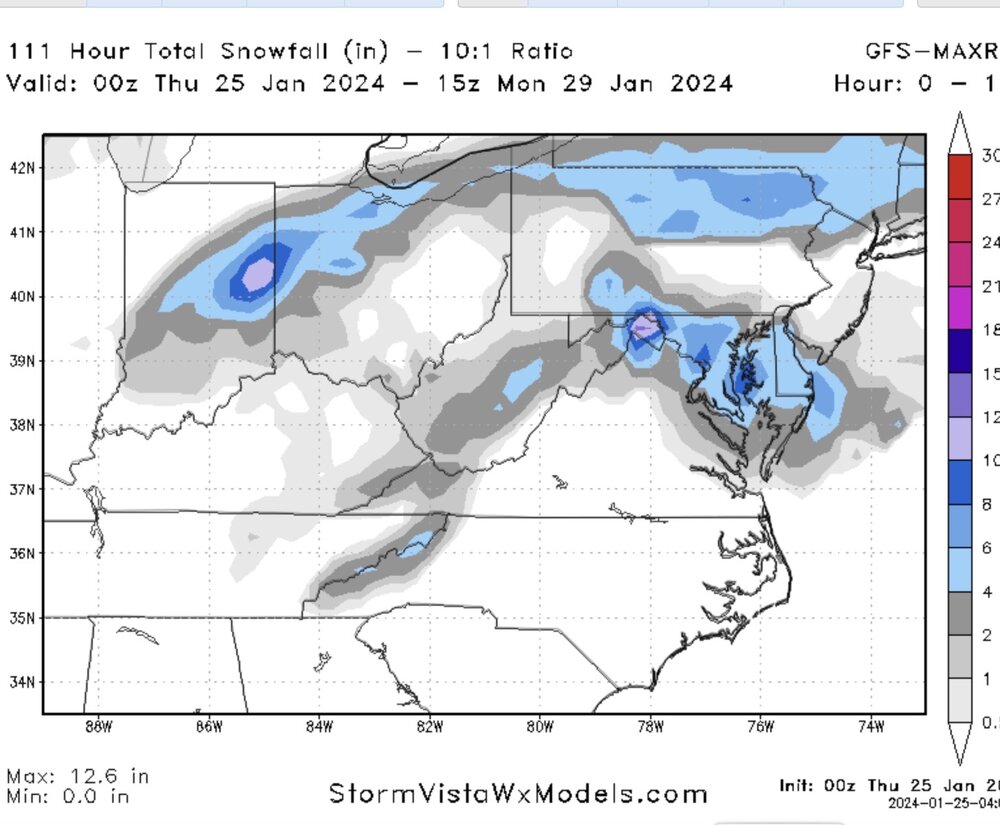
The GFS snow map . I won't ruin it. I'll wait for yall to catch up -
Jan/Early Feb Medium/Long Range Discussion Part 3
stormtracker replied to WinterWxLuvr's topic in Mid Atlantic
Somebody check the soundings between 96 hours and 105 -
Jan/Early Feb Medium/Long Range Discussion Part 3
stormtracker replied to WinterWxLuvr's topic in Mid Atlantic
Guys, it's close to doing something crazy. 850s are much colder this run and the sfc freezing line is farther south vs 18z -
Jan/Early Feb Medium/Long Range Discussion Part 3
stormtracker replied to WinterWxLuvr's topic in Mid Atlantic
So I guess we gonna pretend not to see the GFS keep moving souther and souther with each run? On this one, it's organizing the coast a bit souther. I mean the 850s and the freezing line are pushed further south than 18z -
Jan/Early Feb Medium/Long Range Discussion Part 3
stormtracker replied to WinterWxLuvr's topic in Mid Atlantic
You don't own a mirror, do you? -
Jan/Early Feb Medium/Long Range Discussion Part 3
stormtracker replied to WinterWxLuvr's topic in Mid Atlantic
Nobody get mad. PSU knows I like the lovingly troll him from time to time. -
Jan/Early Feb Medium/Long Range Discussion Part 3
stormtracker replied to WinterWxLuvr's topic in Mid Atlantic
-
Jan/Early Feb Medium/Long Range Discussion Part 3
stormtracker replied to WinterWxLuvr's topic in Mid Atlantic
I think we might be the only ones into this. -
Jan/Early Feb Medium/Long Range Discussion Part 3
stormtracker replied to WinterWxLuvr's topic in Mid Atlantic
The GFS is the only one tho -
Jan/Early Feb Medium/Long Range Discussion Part 3
stormtracker replied to WinterWxLuvr's topic in Mid Atlantic
I mean GFS did it again. I dunno man -
Test from iPhone

-
Jan/Early Feb Medium/Long Range Discussion Part 3
stormtracker replied to WinterWxLuvr's topic in Mid Atlantic
Way more realistic. GFS is smoking dat good stuff -
-
Jan/Early Feb Medium/Long Range Discussion Part 3
stormtracker replied to WinterWxLuvr's topic in Mid Atlantic
Legit lol'd. Anyway, what's after this nonsense? Early feb is our next window? -
Jan/Early Feb Medium/Long Range Discussion Part 3
stormtracker replied to WinterWxLuvr's topic in Mid Atlantic
100% sure the SV maps of 4-6 inches with sfc above freezing and daytime snow for just around DC is going to verify. -
Jan/Early Feb Medium/Long Range Discussion Part 3
stormtracker replied to WinterWxLuvr's topic in Mid Atlantic
12z GFS continuing the same them as 6z for Sunday night. Hmm. SFC is some shit though. -
How many illegal U turns you gonna make on your way to upstate NY?