stormtracker
-
Posts
64,383 -
Joined
-
Last visited
Content Type
Profiles
Blogs
Forums
American Weather
Media Demo
Store
Gallery
Everything posted by stormtracker
-

2024 Valentines Day Rain/Snow/Who The Hell Knows Thread
stormtracker replied to WinterWxLuvr's topic in Mid Atlantic
So far, no remarkable changes vs 6z, but it's super early in the game... -
2024 Valentines Day Rain/Snow/Who The Hell Knows Thread
stormtracker replied to WinterWxLuvr's topic in Mid Atlantic
Gonna be comparing to 6z until 84 hours, then it will be 0z -
2024 Valentines Day Rain/Snow/Who The Hell Knows Thread
stormtracker replied to WinterWxLuvr's topic in Mid Atlantic
Ok, yall....let's see what this episode of the Euro brings... -
2024 Valentines Day Rain/Snow/Who The Hell Knows Thread
stormtracker replied to WinterWxLuvr's topic in Mid Atlantic
Honestly, it's hard to get excited with the Euro and lesser models are not in the neighborhood of the GFS. But maybe the Euro will fold... -
2024 Valentines Day Rain/Snow/Who The Hell Knows Thread
stormtracker replied to WinterWxLuvr's topic in Mid Atlantic
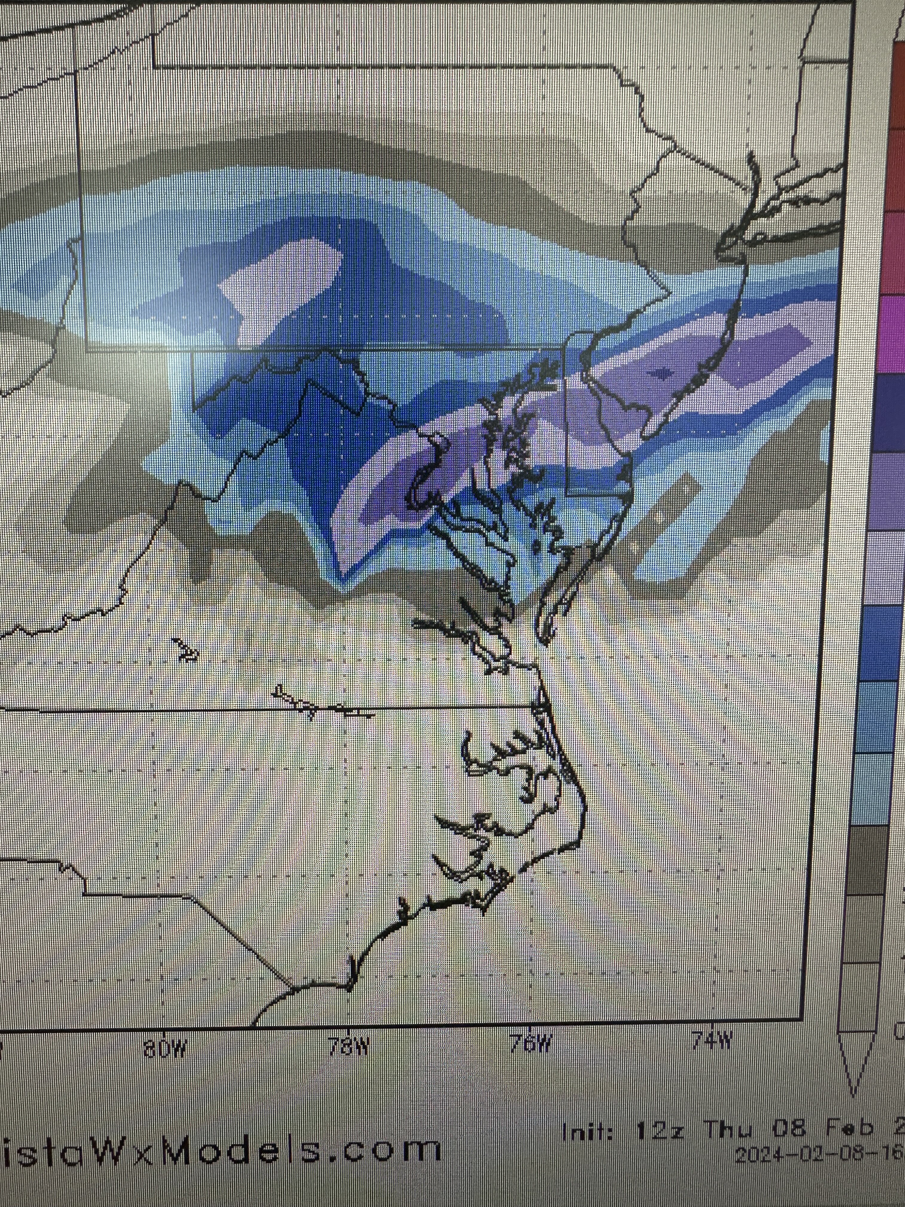
sorry for the shitty pic of a pic...it's quicker than all that screen shot on a PC -
2024 Valentines Day Rain/Snow/Who The Hell Knows Thread
stormtracker replied to WinterWxLuvr's topic in Mid Atlantic
-
2024 Valentines Day Rain/Snow/Who The Hell Knows Thread
stormtracker replied to WinterWxLuvr's topic in Mid Atlantic
Lol...DC 10-12 -
2024 Valentines Day Rain/Snow/Who The Hell Knows Thread
stormtracker replied to WinterWxLuvr's topic in Mid Atlantic
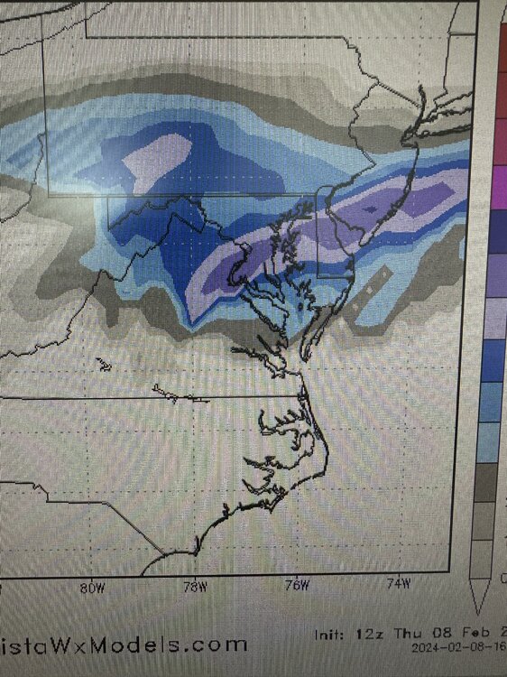
Much more QPF vs 6z -
2024 Valentines Day Rain/Snow/Who The Hell Knows Thread
stormtracker replied to WinterWxLuvr's topic in Mid Atlantic
FOLKS... 21z much heavier precip vs 6z..850 south of us- 563 replies
-
- 21
-

-

-

-

-
2024 Valentines Day Rain/Snow/Who The Hell Knows Thread
stormtracker replied to WinterWxLuvr's topic in Mid Atlantic
It's a slightly colder, better run so far -
2024 Valentines Day Rain/Snow/Who The Hell Knows Thread
stormtracker replied to WinterWxLuvr's topic in Mid Atlantic
15z, 0 850 literally bisects DC..some heavier stuff to our W and SW -
2024 Valentines Day Rain/Snow/Who The Hell Knows Thread
stormtracker replied to WinterWxLuvr's topic in Mid Atlantic
Rain starts around 10z Tuesday...seems to be heavier precip to our south than 6z...storm developing quicker and souther? -
2024 Valentines Day Rain/Snow/Who The Hell Knows Thread
stormtracker replied to WinterWxLuvr's topic in Mid Atlantic
I just hope everyone knows we were supposed to start as rain in the last two runs and don't get alarmed if/when I say rain is on us at x hour -
2024 Valentines Day Rain/Snow/Who The Hell Knows Thread
stormtracker replied to WinterWxLuvr's topic in Mid Atlantic
Still too early to tell, but I do notice it's just slightly more amp'd out in front. Not sure if this is a good thing...odd because the s/w down south is a touch souther...but we'll see in a few -
2024 Valentines Day Rain/Snow/Who The Hell Knows Thread
stormtracker replied to WinterWxLuvr's topic in Mid Atlantic
correct -
2024 Valentines Day Rain/Snow/Who The Hell Knows Thread
stormtracker replied to WinterWxLuvr's topic in Mid Atlantic
Northern stream s/w out front still of the southern stream wave, which is a touch more south west than it was on 6z -
2024 Valentines Day Rain/Snow/Who The Hell Knows Thread
stormtracker replied to WinterWxLuvr's topic in Mid Atlantic
57 hrs...nothing major to report. Almost carbon copy so far. S/w back southwest just a ass hair more southwest, but it's noise at this point. -
2024 Valentines Day Rain/Snow/Who The Hell Knows Thread
stormtracker replied to WinterWxLuvr's topic in Mid Atlantic
No remarkable changes on the GFS vs 6z so far -
2024 Valentines Day Rain/Snow/Who The Hell Knows Thread
stormtracker replied to WinterWxLuvr's topic in Mid Atlantic
Nah. Couldn’t sleep the night before. But sometimes on weekdays I’m on U. Enjoying life is hard. -
2024 Valentines Day Rain/Snow/Who The Hell Knows Thread
stormtracker replied to WinterWxLuvr's topic in Mid Atlantic
12z is prepping to say hold my beer. -
2024 Valentines Day Rain/Snow/Who The Hell Knows Thread
stormtracker replied to WinterWxLuvr's topic in Mid Atlantic
I told y’all that we shouldn’t unpin this.- 563 replies
-
- 12
-
-
2024 Valentines Day Rain/Snow/Who The Hell Knows Thread
stormtracker replied to WinterWxLuvr's topic in Mid Atlantic
I’ll be ready at 12z and 0z. 18z not today (gym). You might be my one and true fan. just don’t be a Selena type fan. Kids, google that reference. -
2024 Valentines Day Rain/Snow/Who The Hell Knows Thread
stormtracker replied to WinterWxLuvr's topic in Mid Atlantic
Sir, this is a storm thread. The panic thread is two doors down. -
2024 Valentines Day Rain/Snow/Who The Hell Knows Thread
stormtracker replied to WinterWxLuvr's topic in Mid Atlantic
I dunno man, but ok. My insomnia finally caught up with me. I was down at like 9:15 last night. lol. I’m just now waking up. -
Fucking human pendulums up in here. I'm dizzy.
- 2,509 replies
-
- 14
-
-
-
- weenie fest or weenie roast?
- weenies got roasted
- (and 2 more)