

GaWx
-
Posts
19,019 -
Joined
Content Type
Profiles
Blogs
Forums
American Weather
Media Demo
Store
Gallery
Everything posted by GaWx
-
The 0Z UKMET has a new TS form in the far E MDR in a week moving WNW: NEW TROPICAL CYCLONE FORECAST TO DEVELOP AFTER 156 HOURS FORECAST POSITION AT T+156 : 10.5N 16.9W LEAD CENTRAL MAXIMUM WIND VERIFYING TIME TIME POSITION PRESSURE (MB) SPEED (KNOTS) -------------- ---- -------- ------------- ------------- 1200UTC 22.08.2023 156 10.5N 16.9W 1006 28 0000UTC 23.08.2023 168 11.1N 19.4W 1006 35
-
For the central MDR lemon: 0Z UKMET NEW TROPICAL CYCLONE FORECAST TO DEVELOP AFTER 150 HOURS FORECAST POSITION AT T+150 : 20.5N 67.7W LEAD CENTRAL MAXIMUM WIND VERIFYING TIME TIME POSITION PRESSURE (MB) SPEED (KNOTS) -------------- ---- -------- ------------- ------------- 1200UTC 22.08.2023 156 21.0N 67.9W 1006 35 0000UTC 23.08.2023 168 21.7N 69.9W 1006 37 From 2AM EDT TWO: up to 20/40 from 10/30 1. Central Tropical Atlantic: Disorganized showers and thunderstorms located over the central tropical Atlantic are associated with an elongated trough of low pressure centered about 600 miles west-southwest of the Cabo Verde Islands. Environmental conditions appear conducive for gradual development of this system, and a tropical depression could form during the next several days while moving toward the west or west-northwest at about 10 mph across the central tropical Atlantic. * Formation chance through 48 hours...low...20 percent. * Formation chance through 7 days...medium...40 percent.
-
Central MDR lemon; 18Z Euro stronger than 12Z and chances increased from 0/10 to 10/30: Tropical Weather Outlook NWS National Hurricane Center Miami FL 800 PM EDT Tue Aug 15 2023 For the North Atlantic...Caribbean Sea and the Gulf of Mexico: 1. Central Tropical Atlantic: A tropical wave, interacting with a larger trough of low pressure, continues to produce disorganized showers and thunderstorms a few hundred miles west-southwest of the Cabo Verde Islands. Environmental conditions appear to be conducive for some gradual development of this system during the next several days as it moves to the west-northwestward or northwestward between 10-15 mph across the tropical Atlantic through the weekend. * Formation chance through 48 hours...low...10 percent. * Formation chance through 7 days...low...30 percent.
-
The SAL is forecasted to diminish substantially starting in ~5 days.
-
-
More on the central MDR lemon: The 12Z EPS still is active with this AEW with ~half the members having TCG though there are fewer H vs the prior run. While having fewer H, it actually is more threatening further west because the tracks are on average further SW with many more going across the LAs and then a good portion of those going well into the Caribbean followed by either dissipation or moving over Hisp/Cuba followed by Bahamas. Some though move NW toward Virgin Islands/PR followed mostly by E of the Bahamas. A few still recurve sharply before the Caribbean and then threaten Bermuda. Bottom line for 12Z EPS vs 0Z: not as many H but centered closer to the US over Bahamas vs 0Z's mainly E of the Bahamas to Bermuda.
-
What I mean by the 12Z Euro having just about nothing is that it has no surface circulation although it has trackable 850 mb vorticity further south. This even leads to a very weak low over FL at 240. The JMA has only a weak reflection at the surface (no circ), but it is a little stronger than the prior 12Z run and pretty much takes the UKMET track from the LAs to the SE Bahamas. You can tell from the widespread 2" of qpf in and near the LAs from this that it has some "oomph" so to speak. Ever since the August 4th EPS runs, this feature has more or less had some model support and it absolutely bears watching! Yet, the NHC still has TCG chances at only 10%. I'd raise them to 30%.
-
Yes, the 12Z GFS has no H. The last on the list with a H is the 6Z GFS. Meanwhile: Some pretty significant model news since the UKMET tends to be conservative: -The 12Z UKMET has TCG from the westernmost lemon in the W MDR on Fri (8/18) and it then hits the Leewards as a TS late on Saturday (8/19). -It then moves WNW to Hispaniola on Mon (8/21) still as a TS -It ends up near SE Bahamas as a slowly strengthening TS on Tue (8/22) moving slowly WNW and in a potentially threatening position to the Bahamas/SE US. NEW TROPICAL CYCLONE FORECAST TO DEVELOP AFTER 78 HOURS FORECAST POSITION AT T+ 78 : 14.2N 51.4W LEAD CENTRAL MAXIMUM WIND VERIFYING TIME TIME POSITION PRESSURE (MB) SPEED (KNOTS) -------------- ---- -------- ------------- ------------- 0000UTC 19.08.2023 84 14.7N 53.5W 1005 30 1200UTC 19.08.2023 96 15.4N 57.4W 1004 34 0000UTC 20.08.2023 108 16.3N 60.5W 1003 37 1200UTC 20.08.2023 120 17.5N 63.5W 1004 40 0000UTC 21.08.2023 132 17.8N 67.0W 1004 37 1200UTC 21.08.2023 144 19.4N 68.7W 1004 38 0000UTC 22.08.2023 156 20.3N 71.2W 1004 37 1200UTC 22.08.2023 168 21.0N 72.9W 1003 39 Edit: But the 12Z Euro like the GFS has just about nothing.
-
GFS 12 runs out of 63 since 7/31 with hurricane (7 of them over last 11 runs)(last 9 H within 8/25-30): -7/31 12Z: hit SC 8/16 -8/3 6Z: GOM hit MX/TX border 8/16 -8/6 0Z: MDR 8/18-21 -8/9 18Z: just off SC 8/25 -8/11 0Z: GOM just off LA 8/26 -8/13 0Z: GOM 8/26-8 -8/13 6Z: GOM 8/25-6 that hits MS 8/26-7. -8/13 18Z: GOM 8/25 hits S TX 8/26 -8/14 0Z : off SC/NC 8/26-29 -8/14 6Z: off NC 8/28-30 -8/14 12Z: GOM 8/27 hits LA 8/28 -8/15 6Z: GOM 8/26 hits FL Panhandle 8/27
-
Largest ONI rises on record from one fall/winter to next: 1972-3: +3.0 1997-8: +2.9 1965-6: +2.8 1951-2: +2.7 1976-7: +2.6 1918-9: +2.6 1925-6: +2.5 2009-10: +2.4 1982-3: +2.4 1911-2: +2.3 1957-8: +2.2 1899-00: +2.2
-
1. Please post the Tweet. 2. The CANSIPS run I'm looking for would have been released 7/31/23 because they're issued at EOM. 3. I just eyeballed via Tropical Tidbits the 7/31/23 CANSIPS SSTa maps covering Nino 3.4. They are the warmest yet for NDJ by a good margin. The previous warmest 2023 runs were the 4/30 and 5/31 runs, which were both 1.83. Then 6/30 cooled to 1.61. But 7/31 warmed substantially to even warmer than 4/30 and 5/31. Based on my estimate, it does appear that the 7/31 run is slightly warmer than 2.00 for NDJ. 4. So, that means that the latest CANSIPS, JMA, Euro, CFS, Meteo-France and BoM are all warmer than +2.00 for the ONI peak. The only one that isn't per the latest I've been able to find is UKMET, which was at +1.82. But that one is from about a month ago. Thus I expect an update soon. 5. So, with CANSIPS making at least 6 of the 7 latest runs peaking as a super Nino, I'm now going likely (say 60%) for a peak warmer than 2.00. If the new UKMET turns out to also be warmer than 2.00, that would make it 7 of 7 and I'd then probably raise the chance for a super peak further. 6. I'll be following the OHC very closely to see if it starts warming back up substantially. It has started to rewarm but only slowly so far per the latest to the +0.80s. I'm expecting it to rewarm more quickly over the next couple of months. In order to support a super ONI peak, that is pretty much a necessary requirement though it doesn't have to warm all the way to +2.0+:
-
For the first time on the subject of projected ONI peak, I'm pretty close to agreeing with you. You had always been significantly warmer than me. For awhile you mainly only had BoM and Meteo-France agreeing. Then the Euro and CFS joined in. But the straw that broke the camel's back for me was the JMA warming as much as it did when considering that it had gained a good reputation here and my analysis suggesting a slight cool bias for it. This is all telling me that an ONI peak of +2.1 to +2.5 has about as much chance as any other interval as of now. Should we get a super peak, you would deserve kudos for calling a super peak very early. By the way, a super peak would mean an anomaly rise of 3.0+C from the low point of last year. The record largest rise is the 3.1 from 1971-2 to 1972-3.
-
-You may end up right as nobody knows. It won't upset me at all if you end up being correct. But I just don't think you'll be right. -I'm aware of the dust but aren't the models? -Will the widespread dust last through the end of the month? -Are there development areas of the basin that won't have much dust for much longer? What about the GOM, for example?... -As usual, lots of uncertainty which makes these forecasting discussions that much more interesting. Without the uncertainty, it would be pretty boring as there'd be no challenge to forecast and thus no debates. -Edit: For the first time in 3 runs, the UKMET has no TCG over its 7 day forecast period. However, the best chances for TCG are in week two imo. Also, the UKMET tends to be conservative.
-
A quiet first half of August for sure but the second half is looking to be much more active per model consensus. The consensus looks nothing like the dead model consensus from one year ago at this time. There are as of now at least four second half of August possibilities per models. I'm sticking with 2-3 named storms from these at this point and even can't eliminate the chance for four.
-
0Z UKMET develops a wave behind the one that the 12Z developed and at a lower latitude while moving it WNW: NEW TROPICAL CYCLONE FORECAST TO DEVELOP AFTER 162 HOURS FORECAST POSITION AT T+162 : 12.0N 20.4W LEAD CENTRAL MAXIMUM WIND VERIFYING TIME TIME POSITION PRESSURE (MB) SPEED (KNOTS) -------------- ---- -------- ------------- ------------- 0000UTC 21.08.2023 168 12.7N 22.3W 1009 24
-
BoM new run: -3.4: Sep, Oct slightly cooler with Sep +2.0 vs +2.2 prior run -3.4: Nov, Dec, Jan about same with NDJ ONI of +2.85 to +2.90 vs +2.80 to +2.85 prior run -Nino 3, Nino 4, and IOD similar small changes
-
GFS runs since 7/31 with hurricane: 3 of last 4 -7/31 12Z: hit SC 8/16 -8/3 6Z: hit MX/TX border 8/16 -8/6 0Z: MDR 8/18-21 -8/9 18Z: just off SC 8/25 -8/11 0Z: GOM just off LA 8/26 -8/13 0Z: GOM 8/26-8 -8/13 6Z: GOM 8/25-6 that hits MS 8/26-7. -8/13 18Z: GOM 8/25 hits S TX 8/26
-
- The stronger August JMA run is following the recent overall model consensus being stronger in 3.4. - It rose sharply to ~+2.2 for both OND and NDJ compared to a +1.76 peak for OND in last month's run. The run from two months ago was at +1.87. - The significance of the JMA being this warm is that unlike a number of models it has generally averaged slightly too cool on the order of 0.1 in nearby runs to 0.3 several months out. - Thus this along with the latest CFS, Euro, Meteo-France, and BoM all being pretty safely in super territory tells me that the chance for a super strong ONI peak has risen sharply (though I still feel that BoM is too warm). I haven't seen the new UKMET nor CANSIPS yet. July UKMET/CANSIPS peaked at +1.82/+1.61. -Based on this along with recent actual warming and a sharp SOI drop, I feel that the chance for a super ONI peak has risen sharply from slight to 50%. The main things holding me from raising it even more are that raising it to just 50% is quite a rise and the OHC fell sharply from +1.30 in mid June to +0.75 in late July. However, OHC looks to be warming now and I do expect significant warming over the next few months. - Nino 1+2 is also significantly warmer this month on the JMA for Dec with ~+2.4 vs ~+1.7 last month. - Nino 3, Nino 4, and IOD all also rose significantly.
-
On the 12Z EPS through 240, I counted 15 Hs (30% of members) at a minimum from just the wave now in the E MDR. There's something like 30 members from all of the waves, combined, with a H. There still are four different possibilities to watch during the next ten days.
-
Similar to the 12Z UKMET, the 12Z Euro has a recurving TS well out in the MDR, which appears to be from the subsequent AEW to emerge from Africa in a few days rather than the one west of there.
-
The 12Z GEFS has 6 hurricanes out of 31 members in the GOM or NW Caribbean on Aug 25th. Keep this in mind:
-
For the first time recently, the UKMET has Atlantic TCG (favoring recurving from the MDR): NEW TROPICAL CYCLONE FORECAST TO DEVELOP AFTER 138 HOURS FORECAST POSITION AT T+138 : 16.7N 42.6W LEAD CENTRAL MAXIMUM WIND VERIFYING TIME TIME POSITION PRESSURE (MB) SPEED (KNOTS) -------------- ---- -------- ------------- ------------- 1200UTC 19.08.2023 144 16.8N 42.7W 1009 29 0000UTC 20.08.2023 156 17.1N 43.1W 1008 31 1200UTC 20.08.2023 168 17.8N 43.8W 1007 33
-
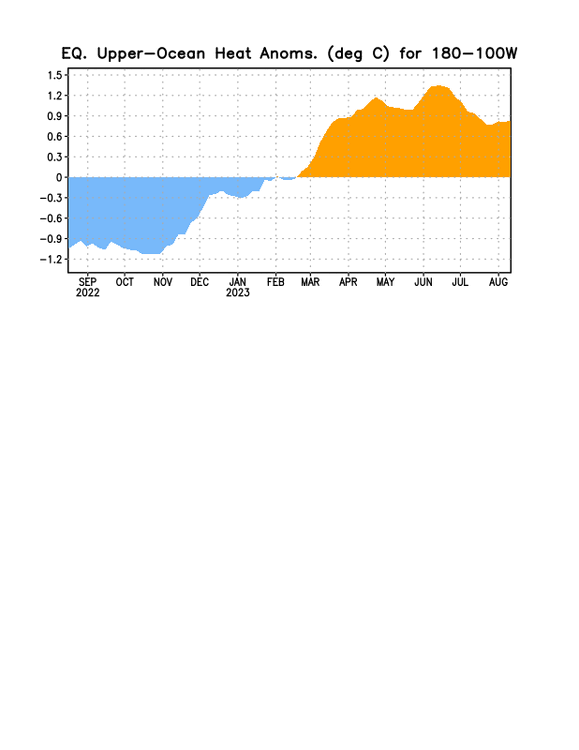
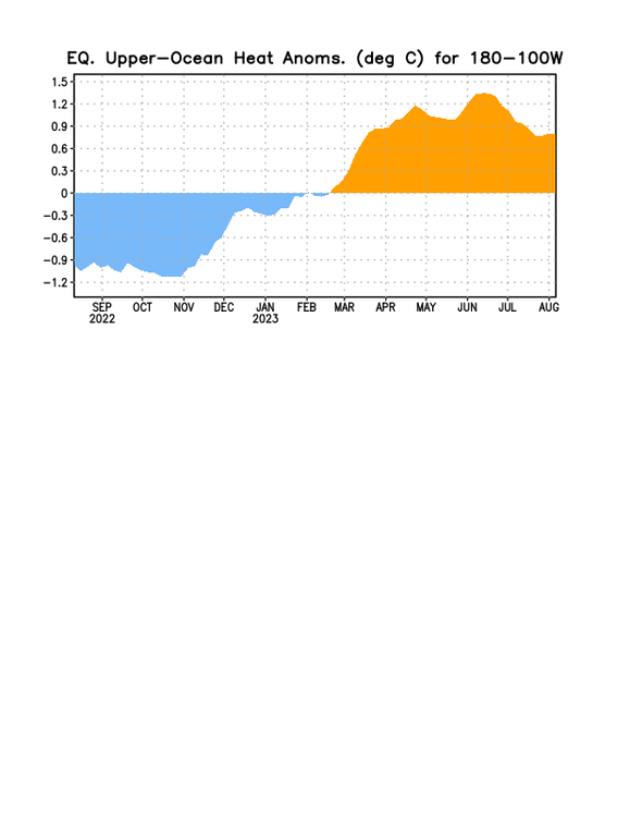
It does look like the OHC plunge has ended and is starting to rebound per the following, which is consistent with your animation's warming west of 140W. I'm expecting mainly net warming the next few months:
-
1. I agree about the CFS run and the near term SAL. 2. Nevertheless, it is just one CFS run that inactive recently and it is an inferior model. 3. This map of SAL is for only for three days from now. SAL tends to decline rather rapidly past mid August. We'll see. Much of the EPS activity occurs well after the time of this map. Also, the TCGs of the last four GFS runs with TCG occur 9-10 days after this map, a near eternity during this period that ramps up rapidly climowise. I'm currently favoring the last week or so of August to be active with 2 TCGs just during that period a good possibility. Edit: 4. I have for the entire season felt that the hyper forecasts for 2023 are well overdone. Just look at my 2023 season forecast contest entry to see what I was thinking at the start. But that doesn't mean I think it will remain dead the rest of this month like was the case in 2022. Obviously I don't think that as per my recent posts. I think 2-3 TCGs this month, mainly during or just before the last week. That would be nothing like the zero TCGs of last August.
-
1. Today's 0Z CFS develops only 1 of the 4 possibilities now being watched. 2. Today's 0Z EPS while still quite active isn't quite as active as yesterday's 12Z with the AEW now in the E MDR. And it is still much more active than those from the same time last year. Like night and day. 3. Today's 6Z GFS is the 7th since 7/31 with a H, this one appearing to form from a southern extension of the wave now in the E MDR. Thus it looks to me like at least the 4th GFS run with a H from this AEW. Also, today's 0Z and 6Z GFS are the first consecutive runs since 7/31 with a H. Prior to this, the closest that two GFS runs since 7/31 had a H was five runs apart: -7/31 12Z: hit SC 8/16 -8/3 6Z: hit MX/TX border 8/16 -8/6 0Z: MDR 8/18-21 -8/9 18Z: just off SC 8/25 -8/11 0Z: just off LA 8/26 -8/13 0Z: GOM 8/26-8 -8/13 6Z: GOM 8/25-6 that hits MS 8/26-7


