

GaWx
-
Posts
11,524 -
Joined
Content Type
Profiles
Blogs
Forums
American Weather
Media Demo
Store
Gallery
Posts posted by GaWx
-
-
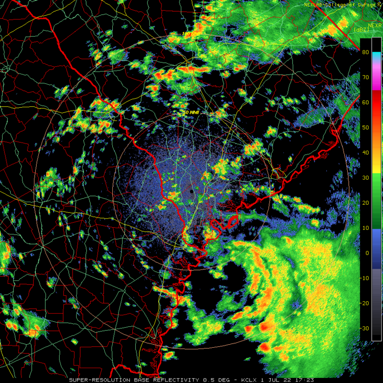
Due to a coastal low/trough and the associated deep Atlantic moisture, I've received 4" since midnight (so all of it counts for July) with 3.5" of that during just midnight-3AM causing significant street flooding. This is the heaviest daily rainfall here since way back on 9/20/21, which wasn't from a tropical cyclone as that was due to converging surface flow off the Gulf and Atlantic (although moisture may have been enhanced by the remnants of Nicholas).
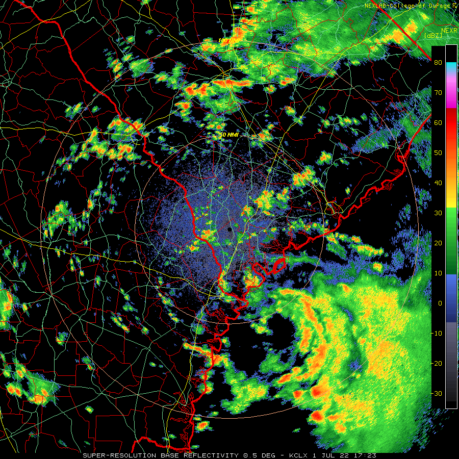
The low center, which is getting a bit better organized and now is 30 miles ESE of Tybee Island/ESE of here (see radar image below), is now far enough north to reduce the heavy rain potential here due to not as much Atlantic moisture as earlier. The wettest flow was when the low was further south of our latitude earlier today giving us a SE/direct flow off the ocean. Now the flow is light from the north (land). It remains to be seen whether or not any more significant rain falls here today considering that the low is slowly moving north. The heaviest rainfall accumulation threat/flooding for the rest of today should be NE of here over coastal SC although it wouldn't surprise me if I were to get some short periods of heavy rain in showers.--------------
From the recent MCD
Mesoscale Precipitation Discussion 0423
NWS Weather Prediction Center College Park MD
1224 PM EDT Fri Jul 01 2022

Areas affected...Coastal Lowcountry of Georgia and South Carolina

Concerning...Heavy rainfall...Flash flooding possible

Valid 011623Z - 012200Z

Summary...Coastal low pressure will bring heavy rain to the coasts
of Georgia and South Carolina through this evening. Rainfall rates
of 1-2"/hr will likely train onshore, leading to instances of
flash flooding.

Discussion...An area of low pressure is clearly evident on the
regional radar mosaic this morning as a closed swirl of
reflectivity just east of Tybee Island, GA. This circulation has
become better organized this morning along an inverted trough, and
is responsible for heavy rainfall exceeding 4 inches that fell
near Chatham, GA overnight.
-
 1
1
-
-
1 hour ago, nwohweather said:
What a look on the radar

Due to this coastal low/trough and the associated deep Atlantic moisture, I've received 4" since midnight with 3.5" of that during just midnight-3AM causing significant street flooding. This is the heaviest daily rainfall here since way back on 9/20/21, which wasn't from a tropical cyclone as that was due to converging surface flow off the Gulf and Atlantic (although moisture may have been enhanced by the remnants of Nicholas).
-
1
-
-
I got 0.15" yesterday to finish June at 7.0". After being in drought conditions for quite a long time and being about the driest of anywhere in the SE from mid November through May 20th, things have suddenly turned around here since then. Hoping many of the still dry areas in the SE have better luck in July.
My June hottest was 102.7 early afternoon on June 23rd, the hottest for any day in at least several years!
After midnight tonight, my area unexpectedly got slammed. But the details of that will have to wait for the July thread.
-
1 hour ago, ORH_wxman said:
Update:
The accelerated melt ponding from the dipole has pushed 2022 more toward the higher melt years of the pack now instead of being near the high-retention years....but still not into the highest tier level like 2012.
NSIDC SIA on 6/29/22 stood at 7.12 million sq km. Below are how other years compared on the same date:
2021: +40k
2020: -50k
2019: -280k
2018: +490k
2017: +310k
2016: +20k
2015: +410k
2014: +400k
2013: +560k
2012: -510k
2011: -30k
2010: -310k
2009: +910k
2008: +550k
2007: -180k
I'm away the next few days but I'll have my final prediction for SIA minimum when I get back and the 6/30 and 7/1 data is in. Unless there are drastic changes over the next couple days, this year's prediction is probably going to be somewhere between a top 5 and top 10 melt year....I don't think it has quite enough juice to make a top 3 and the dipole recently has done enough damage to take a result like 2009/2013/2014/2018 out of the equation.
This means that during the last nine days vs the average of the last 15 years, 2022 has had a pretty dramatic 380K downturn from +240K to -140K (just over 40K/day).
Recap of current vs avg. of last 15 years as of:
6/15/22: +70K
6/16/22: +120K
6/20/22: +240K
6/22/22: +140K
6/29/22: -140K
-
1
-
-
On 6/4/2022 at 5:06 PM, GaWx said:
The latest weekly as well as May, 2022, overall, were the coldest for their respective periods in Nino 3.4 since 1999:
Weekly: https://www.cpc.ncep.noaa.gov/data/indices/wksst9120.for
Monthly: https://www.cpc.ncep.noaa.gov/data/indices/ersst5.nino.mth.91-20.ascii
Related to this, the met. spring SOI of +16.8 was the 2nd highest on record by a good margin going back to 1876. Only 1917's +18.3 was higher:
This SOI update suggests that a third in a row La Niña fall or winter peak is quite possible, if not likely, and that El Niño won't happen:
- June 2022 SOI of +15.7 is the most positive June SOI since 1950 and second most positive June of last 100 years
- Apr-June 2022 SOI of +18.1 is the second most positive on record by a good margin (back to 1876) with only 1917's +19.2 being higher
- The last time a three calendar month SOI was more positive for ANY three month period than the current +18.1 was the strong La Niña of 2010-11, when it peaked at +22.4.
- Prior to that, the only more positive three calendar month SOI periods of the last 100 years for ANY part of the year were the upper teens to low 20s leading up to or during the strong La Niñas of 1988-9, 1975-6, and 1973-4! Before that, one has to go all the way back to the lead up to the moderate La Niña of 1917-18, when the 3 calendar month hit an all-time record high of +29.5 during July-Sept. Prior to that, you have to go back to the +21.0 of the borderline mod/strong La Niña of 1889-90 and the +20.1 of the lead up to the borderline weak/moderate La Niña of 1879-80.
- The highest 3 month +SOI lead up periods (April-June or later) to the 49 El Niños back to 1876-7 were the +12.9 of Jun-Aug of 1900, the +10.2 of May-July of 1968 and the +10.1 of Apr-June of 1904. Compare those to the current +18.1.
- June-Aug of 1950 was +18.0 and lead up to a cold neutral. Jul-Sep of 1878 was +14.9 and also lead up to a cold neutral. Thus, neutral, especially cold, is still a reasonable possibility, especially considering the recent warming of both Nino 3.4 to -0.6 and the OHC.
- I like to include the SOI in the mix for ENSO predictions because it, especially the 90 day, often is a decent leading (as opposed to lagging) indicator of general trends and the hard data goes back ~150 years making for good opportunities for analysis.
- All of this fwiw because ENSO predicting isn't for the faint of heart as ENSO actuals will surprise you when you least expect it.
Monthly SOI back to 1876:
-
2
-
-
^ Interesting stat. Here is that record tying 10th PTC advisory:
Potential Tropical Cyclone Two Advisory Number  10
NWS National Hurricane Center Miami FL       AL022022
1100 PM EDT Wed Jun 29 2022

...CENTER OF THE DISTURBANCE APPROACHING THE GUAJIRA PENINSULA...


SUMMARY OF 1100 PM EDT...0300 UTC...INFORMATION
-----------------------------------------------
LOCATION...12.0N 70.6W
ABOUT 65 MI...105 KM ESE OF NTHRN TIP OF GUAJIRA PNSULA COLOMBIA
ABOUT 890 MI...1435 KM E OF BLUEFIELDS NICARAGUA
MAXIMUM SUSTAINED WINDS...40 MPH...65 KM/H
PRESENT MOVEMENT...W OR 275 DEGREES AT 21 MPH...33 KM/H
MINIMUM CENTRAL PRESSURE...1009 MB...29.80 INCHES
-
Potential Tropical Cyclone Two Advisory Number   9
NWS National Hurricane Center Miami FL       AL022022
500 PM AST Wed Jun 29 2022

...HURRICANE AND TROPICAL STORM WATCHES ISSUED FOR PORTIONS OF
NICARAGUA AND COSTA RICA...


SUMMARY OF 500 PM AST...2100 UTC...INFORMATION
----------------------------------------------
LOCATION...11.6N 69.0W
ABOUT 50 MI...80 KM S OF CURACAO
ABOUT 180 MI...285 KM ESE OF NTHRN TIP OF GUAJIRA PNSULA COLOMBIA
MAXIMUM SUSTAINED WINDS...40 MPH...65 KM/H
PRESENT MOVEMENT...W OR 280 DEGREES AT 21 MPH...33 KM/H
MINIMUM CENTRAL PRESSURE...1009 MB...29.80 INCHES
-------------------------
Potential Tropical Cyclone Two Discussion Number   9
NWS National Hurricane Center Miami FL       AL022022
500 PM AST Wed Jun 29 2022

The system has changed little in organization today, and
in fact has taken on a more elongated appearance.  Most of the
heavier showers and stronger winds are occurring in a long band over
the northern portion of the disturbance.  Reports from a NOAA
Hurricane Hunter aircraft and a Dvorak classification indicate that
the current intensity remains near 35 kt.  High-resolution visible
satellite images suggest that the system may trying to close off a
center to the south of the ABC Islands, but the surface
observations are still not very conclusive.  Radar images from
Curacao also do not yet show a definite center.  The system
could make the transition to a tropical cyclone at any time.

The initial motion continues to be rapidly westward, or 280/18 kt.
There is not much change in the track forecast reasoning.
The flow on the southern side of a large mid-tropospheric ridge to
the north of the system should maintain a mainly westward track for
most of the forecast period.  The latest HCCA prediction shows a
slightly more southern track after 1-2 days than before, likely due
to the input from the ECMWF model.  The new NHC forecast is not
much different from the previous one, but is only a little farther
south after 36 hours or so.

Since the system is expected to remain in a low-shear environment,
it is likely to strengthen after it moves away from the influence
of the South American land mass.  The system is expected to
approach hurricane strength over the southwestern Caribbean, and a
Hurricane Watch has been issued for a portion of the
Caribbean coast of Nicaragua.  After some expected weakening from
crossing Central America, the system should regain strength over the
eastern North Pacific basin.

KEY MESSAGES:

1.  Heavy rainfall is expected to spread westward across the ABC
Islands, portions of northern Venezuela, and northeast Columbia
through Thursday morning, and reach Nicaragua and Costa Rica by
Friday. Areas of flash flooding are expected, along with the
potential for mudslides.

2.  Winds to tropical storm force are expected over the ABC Islands
for the next few hours. Tropical storm conditions are expected along
the northwestern coast of Venezuela and the northeastern coast of
Colombia tonight and early Thursday.

3.  Hurricane conditions are possible within the Hurricane Watch
area along the Caribbean coast of Nicaragua by late Friday, with
tropical storm conditions possible by Friday afternoon.
FORECAST POSITIONS AND MAX WINDS

INIT  29/2100Z 11.6N  69.0W   35 KT  40 MPH...POTENTIAL TROP CYCLONE
 12H  30/0600Z 11.8N  71.8W   35 KT  40 MPH...TROPICAL CYCLONE
 24H  30/1800Z 12.0N  75.6W   40 KT  45 MPH
 36H  01/0600Z 11.7N  79.4W   50 KT  60 MPH
 48H  01/1800Z 11.4N  82.4W   60 KT  70 MPH
 60H  02/0600Z 11.1N  85.1W   35 KT  40 MPH...INLAND
 72H  02/1800Z 11.2N  87.7W   35 KT  40 MPH...OVER WATER
 96H  03/1800Z 12.3N  92.7W   50 KT  60 MPH
120H  04/1800Z 13.5N  98.5W   65 KT  75 MPH

$$
Forecaster Pasch
-
For the first time in 2 weeks (6/14), I'm getting a big dousing from thunderstorms. Been getting them for the last 1.5 hours (since 1:20 PM) and will thus add up nicely. There is some street flooding. I'll provide the total later. Until today, most of my rain this month fell 6/8-14. I got a modest amount yesterday (0.25") bringing me to 4.35" MTD before today's dousing.
Recent radar:
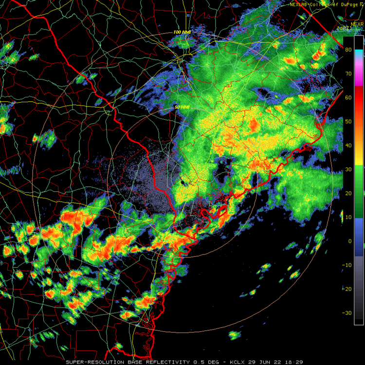
Edit for Flood advisory issued 1/2 hour ago and also this report in the area of 2.48" in only one hour:
0312 PM HEAVY RAIN 1 NNE VERNONBURG 31.98N 81.11W 06/29/2022 M2.48 INCH CHATHAM GA
It looks like 2.5" has fallen IMBY, which brings me to 6.85" MTD (slightly above the longterm mean for all of June). This makes it the heaviest for any one day since way back on 11/6/21, when a similar amount fell. That amount is as much as I got in all of May.
-
1
-
-
Potential Tropical Cyclone Two Discussion Number   6
NWS National Hurricane Center Miami FL       AL022022
1100 PM AST Tue Jun 28 2022

Satellite imagery suggests that the disturbance is slowly getting
better organized, with gradually increasing convective banding in
the northern semicircle.  However, surface observations from
Trinidad, Tobago, and Grenada indicate that the system has not yet
developed a closed circulation.  Therefore, it still has the status
of a potential tropical cyclone.  The initial intensity remains 35
kt based on the various surface observations.

The disturbance is forecast to be in an environment of low shear and
warm sea surface temperatures if it remains offshore, and this
should lead the system to become a tropical cyclone in 12-24 hr.
Strengthening is likely to be slow until the system moves away from
the coast of South America after 36 h, at which time a faster
development appears likely.  The new intensity forecast is similar
to the previous forecast and calls for the system to reach hurricane
strength over the southwestern Caribbean Sea by the 72 h point.
Later in the forecast period, the global models still suggest that
the cyclone's low-level circulation will remain intact after
crossing Central America and this is also shown by the NHC forecast.

The system is moving a little faster with the initial motion now a
somewhat uncertain  285/23 kt.  A general westward motion near or
just north of the coast of South America with some decrease in
forward speed is expected during the next day or two due to the
presence of a low- to mid-level ridge to the north.  A south of west
motion may occur for a time while the system is over the
southwestern Caribbean Sea. The new forecast track is similar to the
previous track is lies close to the various consensus models.


KEY MESSAGES:

1.  Heavy rainfall is expected to spread westward across the
Windward Islands and parts of northern Venezuela tonight through
late Wednesday night. Localized flash flooding will be possible.

2.  Winds to tropical-storm-force are expected over portions of the
southern Windward Islands for a few more hours, over Islas
Margarita Wednesday morning, and over the ABC Islands by Wednesday
evening.  Tropical storm conditions are possible along the
northeastern coast of Venezuela tonight and early Wednesday.

3.  There is a greater-than-normal uncertainty in the system's
forecast intensity once it reaches the southwestern Caribbean Sea
late Thursday and Friday, which will depend on how much it interacts
with land from tonight through Thursday.


FORECAST POSITIONS AND MAX WINDS

INIT  29/0300Z 10.9N  62.8W   35 KT  40 MPH...POTENTIAL TROP CYCLONE
 12H  29/1200Z 11.3N  65.5W   35 KT  40 MPH...POTENTIAL TROP CYCLONE
 24H  30/0000Z 11.8N  69.2W   35 KT  40 MPH...TROPICAL CYCLONE
 36H  30/1200Z 12.3N  72.9W   40 KT  45 MPH
 48H  01/0000Z 12.3N  76.6W   45 KT  50 MPH
 60H  01/1200Z 12.2N  80.2W   55 KT  65 MPH
 72H  02/0000Z 12.0N  82.9W   65 KT  75 MPH
 96H  03/0000Z 12.0N  87.9W   35 KT  40 MPH...OVER PACIFIC OCEAN
120H  04/0000Z 13.5N  93.5W   25 KT  30 MPH

$$
Forecaster Beven
-
Tuesday 6/28 was the first day in 1.5 months with it not colder than normal north of 80N:
-
1
-
-
Thanks, Mike.
NHC 5 PM update:
Potential Tropical Cyclone Two Discussion Number   5
NWS National Hurricane Center Miami FL       AL022022
500 PM AST Tue Jun 28 2022

The disturbance continues to generate strong convection with some
banding features over the northern portion of the system.
Nonetheless, observations from a NOAA Hurricane Hunter aircraft,
including Tail Doppler radar wind data, along with imagery from the
Barbados radar indicate that the system still lacks a closed
circulation.

Given that the disturbance should continue to move through a
low-shear and moderately moist atmospheric environment for the next
couple of days, some intensification is possible, and the
system is expected to make the transition to a tropical cyclone
on Wednesday.  However interaction with land, including low-level
inflow off the land mass of South America will likely limit
intensification until the system reaches the southwestern Caribbean
Sea later this week.  More significant strengthening, possibly into
a hurricane, could occur over the latter region as shown in the
official forecast.  Late in the forecast period, the global models
suggest that the cyclone's low-level circulation will remain intact
after crossing Central America and this is also shown by the NHC
forecast.

Although the center position is not precise, the initial motion
estimate continues to be quickly westward or about 280/21 kt.
There is no significant change to the track forecast philosophy. A
strong mid-tropospheric ridge is expected to be maintained to
the north of the system through this week.  Therefore a continued
westward to west-northwestward motion is expected through the
forecast period.  The official forecast track remains about the
same and closely follows the dynamical model consensus.


KEY MESSAGES:

1.  Heavy rainfall is expected across the Windward Islands,
northeastern Venezuela, and the ABC Islands through Wednesday.
Localized flash flooding will be possible.

2.  Winds to tropical-storm-force are expected over portions of the
southern Windward Islands tonight, over Islas Margarita Wednesday
morning, and over the ABC Islands by Wednesday evening.  Tropical
storm conditions are possible along the northeastern coast of
Venezuela tonight and early Wednesday.

3.  There is a greater-than-normal uncertainty in the system's
forecast intensity once it reaches the southwestern Caribbean Sea
late Thursday and Friday, which will depend on how much it interacts
with land from tonight through Thursday.


FORECAST POSITIONS AND MAX WINDS

INIT  28/2100Z 10.1N  59.5W   35 KT  40 MPH...POTENTIAL TROP CYCLONE
 12H  29/0600Z 10.8N  62.5W   35 KT  40 MPH...POTENTIAL TROP CYCLONE
 24H  29/1800Z 11.4N  66.6W   35 KT  40 MPH...TROPICAL CYCLONE
 36H  30/0600Z 11.9N  70.0W   45 KT  50 MPH
 48H  30/1800Z 12.1N  73.5W   40 KT  45 MPH
 60H  01/0600Z 12.1N  77.0W   55 KT  65 MPH
 72H  01/1800Z 12.0N  80.4W   65 KT  75 MPH
 96H  02/1800Z 12.0N  85.5W   35 KT  40 MPH...INLAND
120H  03/1800Z 13.0N  90.5W   20 KT  25 MPH...OVER THE PACIFIC

$$
Forecaster Pasch
-
1
-
-
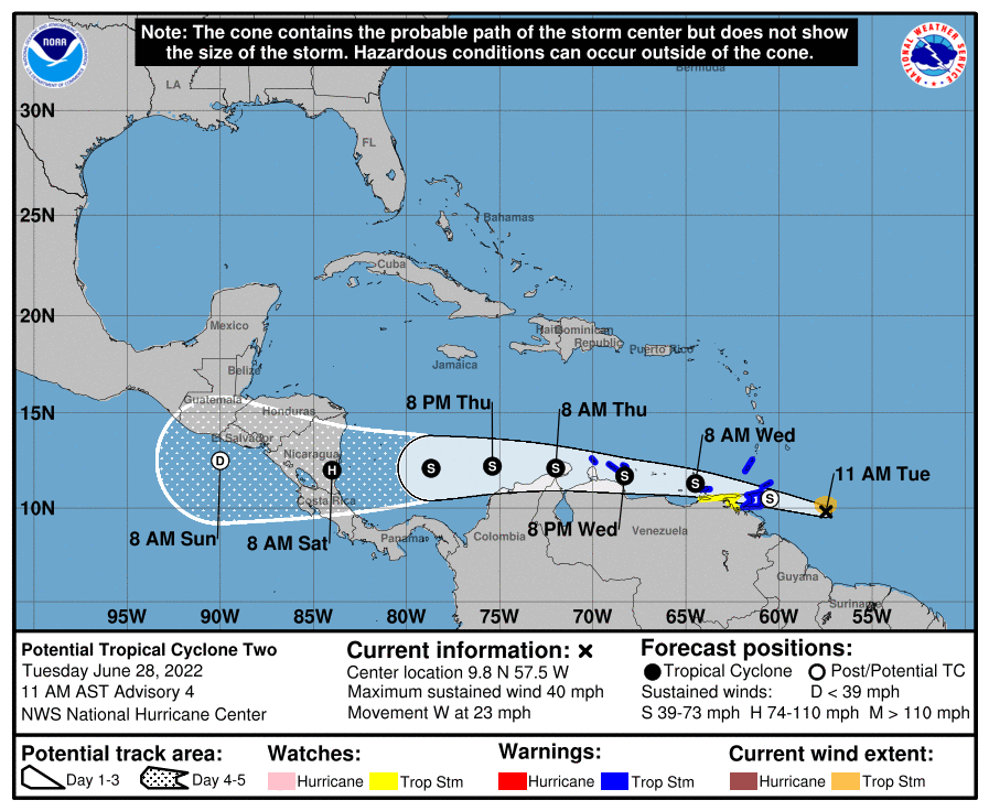
At 1100 AM AST (1500 UTC), the disturbance was centered near
latitude 9.8 North, longitude 57.5 West.  The system is moving
toward the west near 23 mph (37 km/h).  A westward or west-
northwestward motion is expected through Thursday.  On the forecast
track, the system will pass near or over portions of the southern
Windward Islands by tonight, and move over the southern Caribbean
Sea or near the northern coast of Venezuela on Wednesday and
Thursday.

Maximum sustained winds are near 40 mph (65 km/h) with higher gusts.
Some strengthening is forecast during the next few days if the
disturbance remains over water.

Conditions appear conducive for development if the disturbance
remains over water, and it will likely become a tropical storm near
the southern Windward Islands or while moving westward across the
southern Caribbean Sea.
* Formation chance through 48 hours...high ...70 percent.
* Formation chance through 5 days...high...90 percent.

Tropical-storm-force winds extend outward up to 60 miles (95 km)
from the center.

The estimated minimum central pressure is 1009 mb (29.80 inches).
--------------
Potential Tropical Cyclone Two Discussion Number   4
NWS National Hurricane Center Miami FL       AL022022
1100 AM AST Tue Jun 28 2022

The system continues to produce vigorous deep convection and also
exhibits some banding features.  However, reports from an Air Force
Hurricane Hunter aircraft indicate that there is no well-defined
center of circulation at this time.  A NOAA Hurricane Hunter
aircraft is scheduled to investigate the system again this
afternoon.

The system is expected to remain in a low-shear and moderately moist
atmospheric environment for the next couple of days.  However,
interaction with land and fast forward motion will likely limit
intensification until the system reaches the southwestern Caribbean
Sea later this week.  More significant strengthening, possibly into
a hurricane, could occur over the latter area.

Although the center position is not precise, the initial motion
estimate is kept the same, or 280/20 kt.  A strong mid-tropospheric
ridge is likely to remain anchored to the north of the system this
week.  Therefore a continued westward to west-northwestward motion
is expected through the forecast period.  The official forecast
track is mostly unchanged and remains close to the corrected
dynamical model consensus.


KEY MESSAGES:

1.  Heavy rainfall is expected across the Windward Islands and
northeastern Venezuela tonight through Wednesday. Localized flash
flooding will be possible.

2.  Winds to tropical-storm-force are expected over portions of the
southern Windward Islands tonight, over Islas Margarita Wednesday
morning, and over the ABC Islands by Wednesday evening.  Tropical
storm conditions are possible along the northeastern coast of
Venezuela tonight and Wednesday evening.

3.  There is higher-than-normal uncertainty in the system's forecast
intensity once it reaches the southwestern Caribbean Sea late
Thursday and Friday, which will depend on how much it interacts with
land from tonight through Thursday.


FORECAST POSITIONS AND MAX WINDS

INIT  28/1500Z  9.8N  57.5W   35 KT  40 MPH...POTENTIAL TROP CYCLONE
 12H  29/0000Z 10.5N  60.5W   35 KT  40 MPH...POTENTIAL TROP CYCLONE
 24H  29/1200Z 11.3N  64.5W   35 KT  40 MPH...TROPICAL CYCLONE
 36H  30/0000Z 11.7N  68.3W   45 KT  50 MPH
 48H  30/1200Z 12.1N  72.0W   40 KT  45 MPH
 60H  01/0000Z 12.2N  75.4W   50 KT  60 MPH
 72H  01/1200Z 12.1N  78.7W   60 KT  70 MPH
 96H  02/1200Z 12.0N  84.0W   65 KT  75 MPH...INLAND
120H  03/1200Z 12.5N  90.0W   20 KT  25 MPH...POST-TROP/REMNT LOW

$$
Forecaster Pasch
-
1
-
-
1 hour ago, Amped said:
Models have really trended Blah with this storm. It just tracks too close to the south American coast to really get it's act together. Then has 30 hrs or so to organize before hitting central America, where it could potentially spin up rapidly. just before landfall as a CAT1 or strong TS. Disappointed considering there's a lot more potential if it tracked further north.
Additional good news is that it appears it will be moving fast enough to prevent a repeat of the Eta and Iota flooding disasters in Central America though that's not set in stone yet. The projected speed of movement is 2-3 times as fast as those two disasters.
-
4 hours ago, Floydbuster said:
I think a Cat 2 is very possible down there. The waters are boiling and the models seem to show a good upper level environment. As long as it doesn't race too fast or get easterly shear.
While very important for at and near the coast especially and nothing to be taken lightly, I'm not quite as concerned about how strong it may get as I am about track and speed. That's because despite Eta and Iota both being of historical strength, you may recall that it was the incredibly heavy rainfall from slow movement as opposed to the winds and surge that lead to a large portion of the devastation and casualties. The river flooding was horrible. Then again, there likely is a good bit of correlation between how strong they get and how much moisture they can produce and retain for several days after landfall. The areas hit hardest by flooding rains included W Honduras and parts of Guatemala. At the time, Eta caused by far the worst flooding there since Mitch of 1998. And then came another with Iota! The number of refugees caused by this pair of disasters was immense! I just hope this one is moving at a good clip to minimize the potential number of hours of heavy rainfall.
-
2
-
-
Hope this doesn't end up rainwise another devastating Eta or Iota down there!
-
22 hours ago, WxWatcher007 said:
I love big heat, so this is really cool lol
I'll pass lol. No more big heat today in this area despite continued sunshine. How much cooler than 24 hour ago? SAV 10, Hunter 14, Ft. Stewart 11, and SSI 11 all thanks to east winds off the ocean instead of the hot W to NW winds from inland of yesterday.
So, it was quite a potent heat event here but thankfully it was very shortlived with no return of big heat in sight.
-
1
-
 1
1
-
-
Alma, GA, had a new record high for the entire month of June at 105 and also ties the all-time record high set in August of 1995! Records go back to 1938. This was quite the historic day in SE Ga and nearby areas. I think the models did a pretty good job of warning us about this.
-
1
-
-
KSAV has so far at least tied the record high for today at 102. That is already enough to be the hottest in 3 years and the first 100+ in 3 years. That also ties the hottest all of the way back to 2001 and is the hottest in June since 2011.
Edit: SSI had a new record high of 103!
-
 1
1
-
-
1. At 1:15 PM, it hit 102.0 imby!
2. As of 1 PM, Macon is at 99 vs only 94 at Augusta. So, once again, Macon is coming in quite a bit hotter than Augusta.
Edit: 102.7 IMBY 2:55 PM!
Then it suddenly plunged 4 degrees to 98.7 at 3:01 PM! I think this is due to a slight increase in cloudcover as I don't think the wind direction shifted. I guess when it is that anomalously hot, any slight change can easily knock the temp down. I'm assuming our high so far of 102.7 won't be exceeded the rest of the day.
Edit #2: 102 very close to the coast at St. Simons Island at 4 PM is a new record high. They can thank the NW wind totally opposing any chance for a seabreeze.
-
2 hours ago, ORH_wxman said:
Update:
The melt has picked up a bit with the dipole pattern currently in progress across the arctic basin. As of 6/22, the NSIDC SIA stood at 8.09 million sq km.
Here's how other years compared on the same date:
2021: -520k
2020: -430k
2019: -390k
2018: +350k
2017: +20k
2016: -480k
2015: +30k
2014: +70k
2013: +270k
2012: -650k
2011: -140k
2010: -480k
2009: +710k
2008: +50k
2007: -460k
The dipole pattern looks like it will persist for another 4 days or so and then the low currently in the ESS will migrate toward the Beaufort/CAB and produce a reverse dipole which would slow the sfc melt down again.
So the time to rack up losses is right now and the next few days.
This means that the last two days vs the average of the last 15 years has gone from +240K to +140K.
Recap vs avg. of last 15 years as of:
6/15/22: +70K
6/16/22: +120K
6/20/22: +240K
*6/22/22: +140K
*Edited due to typo
-
8 hours ago, Shack said:
Unqualified HOT in Macon today. 106deg at MCN.
That follows a low this morning of 64deg. Very unusual spread of 41 degrees. For June, got to be almost unheard of.
Despite similar conditions, including light winds and sunny skies, and almost identical normal highs, Macon's high on Wednesday was 105 while Augusta's high was "only" 99. Why? It is all about recent rainfall. Last June, for example, their temperatures were very similar, which is typical. Neither then had dry soils.
What's happening now though?
Macon rainfall since 5/25/22: a mere 0.23". So, they literally bake like in a desert.
OTOH, Augusta rainfall since 5/25/22 has been a much higher 2.96". So, much less baking.
Actually the big differential started on June 11th. Before that June 1-10 average highs were similar with Macon at 90.7 and Augusta at 90.6. There had not yet been enough time for large soil moisture differences to have developed.
In contrast, look at June 11th-22nd average highs: Macon 99.1 and Augusta 94.1, a whopping 5.0 difference! Daily differences 6/11-22 Macon minus Augusta:
3, 6, 3, 8, 8, 6, 2, 4, 5, 6, 4, 6
I've found that local rainfall over the prior 3-4 weeks often has a big impact on summer high temperatures and this is a great example.
-
51 minutes ago, ORH_wxman said:
Update:
NSIDC SIA stood at 8.39 million sq km as of 6/20/2022.
Here's where other years stand now:
2021: -580k
2020: -720k
2019 -470k
2018 +90k
2017: -50k
2016: -420k
2015: -170k
2014: -80k
2013: +60k
2012: -740k
2011: -330k
2010: -450k
2009: +710k
2008: +70k
2007: -610k
You can see there's some pretty clear divergence now between the huge melt years and the higher retention years. There's still some time for movement (2008 lost a lot in the final 10 days of June), but 2022 is quickly trending toward years like 2018/2017/2014/2013. There is a dipole pattern setting up over the next week or so....if 2022 is going to make a move toward the big dog melt years, it has to be during this next week.
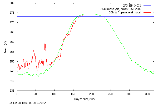
These numbers translate to another nice gain relative to 2007-2021 with 2022 now at +240K vs the mean of those years compared to +120K four days ago and +70K five days ago. Fwiw, the north of 80N temperatures averaged out continue to be slightly colder than the 1958-2002 mean, which can't hurt especially considering every of the last 40 days has been colder than that mean.
-
9 hours ago, WinstonSalemArlington said:
PreSolstice Chill
I see two SE GA circles representing new record lows, but I can't find any that even came that close to a record. I checked the main stations of SAV, Ft. Stewart, SSI, Alma and Waycross. So, this coolwx map doesn't look right.
-
1
-
-
I got no rain today but did get 0.20" yesterday. I'm now at 4.1" MTD, easily the wettest month since November of 2021. My last good dousing was 0.90" on 6/14. Most of my rainfall this month was received June 8-14 (3.3").

2022 Atlantic Hurricane season
in Tropical Headquarters
Posted
Kudos for being on top of this! I'm not saying I'm expecting imminent tropical development, especially with it not too far offshore, but obviously there's plenty of moisture at multiple levels and SSTs are conducive in the area with 82-84 F. So, although conditions for development are far from ideal with areas of moderate+ shear nearby and it not being far from shore, a TD forming from this wouldn't be shocking assuming it stays offshore. It should continue moving very slowly N and then probably NE near or just offshore SC. Regardless of whether or not it becomes a TC, this is interesting to watch spin around and it has and will likely continue to be a significant wx maker in terms of heavy rainfall potential in the coastal Carolinas as it was here earlier today.