wx2fish
-
Posts
2,631 -
Joined
-
Last visited
Content Type
Profiles
Blogs
Forums
American Weather
Media Demo
Store
Gallery
Everything posted by wx2fish
-
Most of the weenie outer cape cwop stations are g70+ now, Truro tickled to 80 in the past half hour
-
0z nam looked a tad slower, ramps up the LLJ by 6z, but doesnt max it across SE MA til around 9z
-
G79mph out on the Truro dunes
-
So this posted on a FB group from Pittsburg. Diamond Ridge, roughly 3000'
-
September Discussion Thread: Bring the frost; kill the bugs.
wx2fish replied to moneypitmike's topic in New England
I've read in some of the town history stuff here saying there were so many downed trees they just started putting them into Canabie Lake. There's been some salvage efforts over the years for pulling out some of the wood. We're also alot more forested now than '38. -
That's probably the busiest part of the lake, but winni is largely a disaster on the weekends. There's plenty of quiter areas, but for the most part the boat traffic is insane.
-
I've been to champlain a few times, but really want to get to the St. Lawrence.
-
Hydro Phil is trying. Make it stop.
-
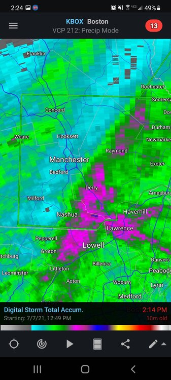
Looks like it cut right through ASH, granted this has some previous rain in the estimate
-
Winding down. Close to 3". Best banding seemed to rotate in Rockingham Co, looks like we almost doubled the ASH/MHT totals
-
Pounding in this band. 1.5-4.75"/hr on the Davis
-
Of all places the McDonald's up in Lancaster had mask signs last weekend. I was on the back from Pittsburg and didn't even have one, but most people inside weren't wearing one.
-
I'm definitely seeing more now than I can recall in the past. My family has a camp on a pond in town and they are everywhere around all the houses and camps near the pond. Probably less predation in that densely populated area.
-
I've seen snowshoe hares up in Pittsburg, but I don't think they have the cottontail population we have down there in SNH. They're everywhere around my area
-
Spent last week up in Pittsburg. Caught a handful of Lakers in the First CT Lake in the 18-22" range. The trophy section of the CT River is low, but fished well. The state stocked a ton of rainbows and bookies into that stretch last Friday. Only downside was more people than usual fishing the river, it was mobbed at times. No huge fish, but a fun trip.
-
I'm up in Pittsburg and saw 39. First Lake is in the low 60s and fogged in hard. Probably kept it just a little warmer. There's always a cool northeast drain across the first lake until about 8am on these calm mornings before the prevailing wind for the day kicks in
-
I hit the canal a couple times when I was down there for my brother's wedding a couple years ago. Couldn't believe the crowds, I've never seen anything like it. Caught some nice fish though.
-
Fished Newfound yesterday. Water in the 39-42F range. Still managed about a dozen smallies on the jerkbait in 6-12ft. Really good quality though with 6 between 3 1/2 and 4lb.
-
The guy running johns site in pittsburg is at least 8". 4" yesterday and 4" today and still snowing
-
Let up for a bit but back to mod-heavy. ~1.5"
-
My 215ft el, on the side of southeast facing hill paying off
-
Took about 30 min here to start coating the driveway. All about those rates.
-
Pounding. Quickly whitened up
-
Just flipped to mostly snow. I'd imagine MHT will report SN on the next ob.
-
Slowly dropping, quite a few pellets mixed in bouncing off the windshield. Probably still some dry air loft, but its been raining for a few hours.