J.Spin
-
Posts
6,421 -
Joined
-
Last visited
Content Type
Profiles
Blogs
Forums
American Weather
Media Demo
Store
Gallery
Everything posted by J.Spin
-
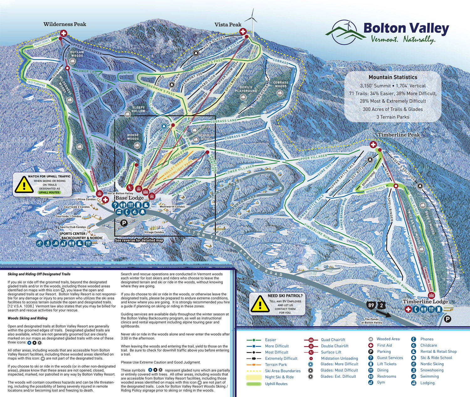
In terms of whether or not to wait another storm cycle, it will depend on the terrain pitch and level of variety you’re looking for. If a couple routes of green/low blue pitch with ~500 verts is enough, that terrain is good to go. Sufficient base is in place below whatever is currently falling, and the only remaining factor left on that terrain is water bars. Any water in them is frozen, and they are covered with snow, but they are not yet filled 100% up to grade with snow, so attention has be paid when approaching/crossing some of them. The Lower Turnpike trail (see the far left of the map below) is where the resort’s Wilderness Uphill Route is located, and it’s also the default descent route for folks that are just looking for a quick outing. It’s about as perfect a setup as you can get for earning turns when the snowpack is just getting going. It starts above 2,000’, it’s well protected from the wind, it’s pitch is low to prevent the scraping associated with the aggressive edging required on higher-angle terrain (folks in the Rockies would probably equate it to “Meadow Skipping”, if you’re familiar with the term), the snow is preserved well because it’s packed to a reasonable degree by skier traffic, and it literally starts right from the Bolton Valley Village for convenient access. The pitch is perfect for bottomless turns on 6”, and up to about 12” of champagne, or reasonably dry, sub 8-10% H2O powder (and ski width will play into it as well). Above those depths, or slightly lower if the snow is dense, you’ll start battling insufficient pitch for fun turns. One huge aspect of Lower Turnpike that people may not notice at first is the fact that while it’s low angle, it’s very consistent, so you’re not battling flat spots (a bigger deal for split boarders, but still a nice touch even for skiers). I remember talking with the former ski patrol director of the mountain, and he was a huge fan of Lower Turnpike indicating that it was actually one of the best trails on the mountain in that regard. For someone who is taking a first foray into skinning for turns in powder, Bolton’s Wilderness area, and specifically the Lower Turnpike trail, is just about the best place I can think of in the Northeast due to the combination of everything I mentioned above, and availability of fresh snowfall since it’s the Northern Greens. A big appeal for someone new to earning turns is the security of being in bounds, right on resort trails. So in that respect, it’s not really “backcountry” skiing, but an added plus as people advance is that one can easily access the resort’s backcountry network right next door using the same ascent route. The backcountry network begins right at the edge of the Wilderness Uphill Route shown on the map, and the details of that area are available on their backcountry network map. Just a few final notes about the Wilderness area – the pitch is roughly green to mild blue on the lower half to two-thirds of the mountain, and above that it gets up into higher blue and black pitches. The higher pitches are much more exposed to the wind, so they are easily scoured. A typical approach I use is to simply ascend as high as the snow quality allows. That’s a good approach if someone is uncomfortable with the skiing due to insufficient base. The bottom half of the Wilderness area is actually so well covered by natural snow that the resort will often open up lift accessed skiing there for skiers to connect over from Vista, long before they start running the Wilderness Chair. I’m not sure if they’re quite there yet, but they are definitely close, since I saw today that they’re starting to open natural terrain on the lower parts of Vista. With the way the snow continues to plow into the spine this evening, it’s definitely got me wondering how close they are. That’s just something to consider in terms of powder access because at that point, lift-served skiers will start to work their way over there as they discover it, and the powder on the lower half of Wilderness will see more traffic. If you have other questions about the setup, just let me know and I’ll be happy to help.
-
Yeah, at one point we had some huge flakes up to ~2” in diameter here at the house – and it’s really high-quality champagne. The 2:00 P.M. analysis was 6.2% H2O, so we’ll see what the next one says. Either way, it looks like the mountains are getting a nice shot of backside snow, and that’s on top of what we already had today. It bodes well for turns tomorrow with those upslope streamers doing their thing.
-
I haven’t been up to the hill since last week as I’ve been waiting for conditions to pick up, but Bolton’s morning snow report indicated 3-4” in the past 24 hours, and that seemed like enough to head up for a ski tour to check out the new snow. Since yesterday’s snow was feather-light with ratios in the 60 to 1 range based on my analyses down here at our site, I was wasn’t expecting it to contribute much in terms of building up the powder depths. I’m sure the depths I found today were bolstered by some of the additional smaller events we’ve seen in the past week, but whatever the case, the combination of those events, yesterday’s snow, and now the addition from Winter Storm Garrett has been substantial. Right off the bat I was finding 4-5” of surface snow at 2,000’ and up at 3,000’ it was 6-7”. The powder wasn’t just fluff either – there was a good deal of substance to it and a great right-side-up gradient with the current upslope snow falling. I was on midfats today, and powder turns were easily bottomless on low and moderate angle terrain that was untracked/unscoured. This past week, and especially these past couple of storms, have been an absolute game-changer for the Wilderness terrain up at the resort. The skiing was nice enough that I decided to stick around to check out the lift-served terrain as well. The past week and the most recent couple of storms have made a difference there too, because they’ve now opened some natural snow terrain, and people are definitely skiing the trees and glades on the lower mountain. I didn’t notice a huge improvement in the quality of the on-piste skiing that I sampled; it was fine, but these recent storms just haven’t delivered enough liquid equivalent to provide a real resurfacing for lift-served levels of skier traffic. There was more good news in terms of the current weather, because there was plenty of snow coming down while I was there. At 2,000’ the snowfall rate was moderate, and it was definitely heavy when I was up around 3,000’ on the Wilderness Summit. Snowfall rates above 2,000’ were notably heavier than what we’ve had down here at the house, and if it keeps up like that for a bit this evening, conditions should move even another notch up tomorrow. A few shots from the mountain today:
-
Event totals: 2.0” Snow/0.15” L.E. Details from the 2:00 P.M. Waterbury observations: New Snow: 1.3 inches New Liquid: 0.08 inches Snow/Water Ratio: 16.3 Snow Density: 6.2 % H2O Temperature: 26.8 F Sky: Light Snow (2-10 mm flakes) Snow at the stake: 5.5 inches
-
Event totals: 0.7” Snow/0.07” L.E. Winter Storm Garrett started up early this morning in our area, and this was one of those situations where you could easily miss out on the break point between this system and the previous one. The lull in snowfall between events was relatively short and took place overnight - my final observations from the previous event were at midnight, and this storm was already underway for this morning’s observations. Details from the 6:00 A.M. Waterbury observations: New Snow: 0.7 inches New Liquid: 0.07 inches Snow/Water Ratio: 10.0 Snow Density: 10.0 % H2O Temperature: 24.4 F Sky: Light Snow (1-5 mm flakes) Snow at the stake: 4.5 inches
-
Event totals: 2.2” Snow/0.03” L.E. Details from the 12:00 A.M. Waterbury observations: New Snow: 0.6 inches New Liquid: 0.01 inches Snow/Water Ratio: 60.0 Snow Density: 1.7% H2O Temperature: 25.3 F Sky: Cloudy Snow at the stake: 4.5 inches
-
Event totals: 1.6” Snow/0.02” L.E. Details from the 6:00 P.M. Waterbury observations: New Snow: 1.3 inches New Liquid: 0.02 inches Snow/Water Ratio: 65.0 Snow Density: 1.5% H2O Temperature: 28.6 F Sky: Light Snow (4-15 mm flakes) Snow at the stake: 4.5 inches
-
I’m planning to run the next liquid analysis at 6:00 P.M., so we’ll see what kind of ratios we’re getting. I think this round of snow is substantial enough that I’ll be able to get measurable liquid vs. the earlier rounds today that were sub 0.01” and thus just a trace.
-
Yeah it’s felt a bit more like getting back to reality with all the snow in the air today and the snowpack getting a fresh covering. Around here in the Winooski Valley at least, the snowfall has certainly been the most intense over the past hour or so with some 28 db echoes showing up:
-
We picked up another tenth of an inch of snow this morning after observations time, and it’s been generally quiet for a while, but there’s just now been a resurgence of flakes with some new echoes on the radar. The regional radar certainly shows moisture streaming off Lake Ontario in this direction, so the additional flakes may be from that event progressing. Area Forecast Discussion National Weather Service Burlington VT 916 AM EST Thu Jan 6 2022 .NEAR TERM /THROUGH FRIDAY/... As of 914 AM EST Thursday...Better late than never! The lake effect snow off of Lake Ontario took a bit longer than was initially thought but is now going in full force. Webcams from Potsdam down to Star Lake and Edwards show light snow falling with radar returns filling in across northern New York. There is likely some virga out there this morning, especially as you head into Vermont, with a dry pocket in the low levels but the forecast across southern St. Lawrence looks to be in good shape at this time. We will continue to watch for streamers off Lake Ontario and make adjustments to snowfall totals as needed.
-
It’s always hard to know what translates over to the mountains of NNH, but what they’ve got in the BTV NWS forecast discussion sounds quite reasonable as usual: Area Forecast Discussion National Weather Service Burlington VT 916 AM EST Thu Jan 6 2022 .NEAR TERM /THROUGH FRIDAY/... …snow will linger along the Green Mountains late Friday, resulting in total snow accumulations up to 4 inches for locations above 1500 ft. I’m currently seeing something in the range 2-4” in the point forecast here at our site, and 3-6” for the high elevations along the spine. The numbers are in range of 0.3”-0.4” of liquid along the spine of the Northern Greens through Saturday on many of the models. That could certainly produce 3-6” if ratios were high as PF mentioned.
-
Man, what’s all the griping been about in the forum threads then? I swear I keep hearing people from SNE saying they haven’t had a good season in something like 3 or 4 seasons, but perhaps that’s just a vocal minority. I don’t really hear as much about Mid-Atlantic snowfall, so I can’t say for that area, but I just heard on TWC that the snow D.C. just had was the biggest in a couple of years, so it seemed like things had been pretty lean. You know, now that I think of it, I do recall hearing about places in New Jersey or thereabouts that had a really good stretch at some point last year, but one would think it didn’t extend much into SNE the way they’ve seemed to be griping? Or maybe it was just weenie unrealistic expectations and such. The thing is, you probably still had more than double the season snowfall of anyone south of you last season, so there’s that perspective to think about as well.
-
Is that what last February was like? I checked my data (February 2021 storms listed below) and I’m seeing two systems that might qualify as “missing to the south” – it looks like Quade and Viola might fit (outside of bench mark) based on the descriptors for each of the February storms that hit here. But then you’ve got far more storms like Orlena, Peggy, Roland, Uri, etc. that moved through, or even north of New England. I guess there could be some storms that didn’t get into my data because they only get in if accumulation is recorded here at our site, but that would be surprising based on what I recall from the tenor of last season. Didn’t the folks in SNE consider last season a dud? We had 47.2” of snow last February here at our site. That’s decent, but I have a hard time imagining anyone in SNE or the Mid-Atlantic had that much snow last February – for most sites down there that would literally make their season by being above their entire season average or getting them there in combination with whatever other snow they picked up. I don’t really have a sense that it was that great down there, unless all the storms missed everyone entirely and were out to sea? The feeling that storms missed to the south last February could be perspective from online media interaction as well. Even though our winter climate up here is vastly different from that of SNE, we wind up being linked with that area because the American Weather sub-forum covers all of New England. SNE has the big cities and population areas, so the forum is sort of centered around storms that affect that area. Meanwhile, a system focused on Montreal to the north of us gets jack squat with respect to attention - the bulk of the forum has probably checked out of extensive online discussion because they’re getting rain. It’s possible that the forum setup exaggerates the apparent frequency of storms that are focused farther to the south? Sure, last February wasn’t a 70” or 80” month up here in terms of snowfall (perhaps at the resorts), but 12 storms (average is 10 to 11 storms) and almost 50” of snow (average is ~40”) still seems like we weren’t shortchanged heavily by that pattern. If someone to the south had a 70”, 80”, or 100” month last February (I believe Coastal had a month like that one season a while back?) I think we would have heard about it. Here’s the storm listing from last February at our site: 1) 10.2” – 2/2/21 - Winter Storm Orlena - slow moving system along Northeast coast 2) 7.4” – 2/5/21 - Winter Storm Peggy - deep, mature cyclone moving north through the Great Lakes 3) 0.1 – 2/6/21 - LES behind occluded boundary due to persistent southwesterly flow aloft 4) 3.3” – 2/7/21 - Winter Storm Quade - coastal storm south of benchmark coupled to northern stream trough 5) 8.2” – 2/9/21 - Winter Storm Roland - weak wave of low pressure passing south of the region 6) 0.1” – 2/11/21 - Weak upper-level disturbance 7) 4.5” – 2/15/21 - Winter Storm Uri - low pressure moving through New England with mixed precipitation 8) 7.7” – 2/19/21 - Winter Storm Viola - low SE of benchmark with multiple shortwaves in deep SW flow 9) 3.0” – 2/22/21 - Low pressure system from Great Lakes passing through New England 10) 0.5” – 2/23/21 - Well-defined shortwave troughs to north and south moving eastward through area 11) 1.8” – 2/24/21 - Low pressure system passing just north of area 12) 0.4” – 2/2721 - Warm front associated with weak frontal system
-
Event totals: 0.2” Snow/Trace L.E. I found 0.2” of fluff on the boards this morning with some flakes falling. I thought it might be from the lake-effect snow that some of the models have shown coming off Lake Ontario, but checking the direction of the flow on the radar and reading the BTV NWS forecast discussion suggests it’s from a cold front pushing though Vermont this morning. Details from the 6:00 A.M. Waterbury observations: New Snow: 0.2 inches New Liquid: Trace Temperature: 30.1 F Sky: Light Snow (4-15 mm flakes) Snow at the stake: 3.5 inches
-
For us not being entrenched in January arctic air, I’d say the number of events has been surprisingly slow for this first week of January – usually those arctic outbreaks when the air is incredibly dry and the storm track is pushed south are our slowest midwinter times. It’s looking like we’ll get into a bit more of a bread and butter pattern going forward over the next week though, with potential systems tomorrow, Friday, Sunday/Monday, Tuesday, and then next Wednesday depending on the model. And it rolls along with a few more beyond that if you just step though the most recent deterministic run of the GFS. Beyond a week it’s just a pattern check of course vs. nailing individual systems, but the theme is there. We’re about 20” behind average snowfall pace at our site now, so there’s some ground to make up. I’d suspect the usual assortment of bread and butter systems would allow us to keep pace, but probably not gain any ground – we’d need a bigger synoptic system or upslope event for that.
-
Event totals: 1.7” Snow/0.21” L.E. We’ve mostly cleared out now, so I’d say the totals above are the final values here at our site for this northern component of Winter Storm Frida. Details from the 6:00 A.M. Waterbury observations: New Snow: 0.2 inches New Liquid: Trace Temperature: 5.2 F Sky: Mostly Clear Snow at the stake: 3.5 inches
-
Event totals: 1.5” Snow/0.21” L.E. Details from the 6:00 P.M. Waterbury observations: New Snow: 0.4 inches New Liquid: 0.01 inches Snow/Water Ratio: 40.0 Snow Density: 2.5% H2O Temperature: 19.6 F Sky: Light Snow (3-10 mm flakes) Snow at the stake: 3.5 inches
-
Event totals: 1.1” Snow/0.20” L.E. Details from the 12:00 P.M. Waterbury observations: New Snow: 0.7 inches New Liquid: 0.04 inches Snow/Water Ratio: 17.5 Snow Density: 5.7% H2O Temperature: 27.1 F Sky: Light Snow (2-20 mm flakes) Snow at the stake: 3.5 inches
-
This holiday week wasn’t an outrageously snowy period for skiing around here in the Northern Greens, but it was actually quite nice in terms of temperatures and conditions. We had a number of days with temperatures in the upper 20s F to around freezing, and an inch or two of new snow here and there to add at least a bit of freshening. Overall it was far superior to holiday weeks where there’s been a huge melt out or wall-to-wall subzero temperatures that make skiing impractical. There’s clearly enough natural snow for Bolton to have their Wilderness Uphill Route and associated terrain open for ski touring, so that was definitely a plus, and it looks like the area saw plenty of use from skiers. Lift-served terrain at the mountain is still somewhat limited as they continue with snowmaking, but they’ve got Hard Luck open for some steep skiing on top of the usual early season routes. My wife and I were out for a snowshoe tour Monday on the backcountry network, I went ski touring in the Wilderness area on Wednesday, and then we skied lift service on Thursday, so I’ve added a few shots from the holiday week below.
-
Event totals: 0.4” Snow/0.16” L.E. This morning we picked up an initial accumulation from approaching Winter Storm Frida, but the bulk of the precipitation is still off to our northwest. There was also 0.02” of liquid in the rain gauge ahead of what have been a transition through mix and very dense snow based on the liquid equivalent found in this morning’s core sample. Details from the 6:00 A.M. Waterbury observations: New Snow: 0.4 inches New Liquid: 0.14 inches Snow/Water Ratio: 2.9 Snow Density: 35.0% H2O Temperature: 27.1 F Sky: Light Snow (1-5 mm flakes) Snow at the stake: 3.0 inches
-
Checking on the averages in my numbers, we should be right at 50” of season snowfall as of today (January 1st). December had a couple of slow snowfall weeks (roughly week 2 and week 4), so we’re only at 35.6” on the season and have some catching up to do. These next couple of systems could certainly help in that department depending on how they play out. There’s also a potential midweek system more in the Wed/Thurs timeframe that could help It’s been interesting seeing that argument among the weenies about whether “losing” December (I assume in terms of snowfall) matters in the scope of the season. I guess it’s no big deal if you average just a few inches of snow in December; one storm can make up that deficit. It also doesn’t seem like November snowfall is much of a factor in SNE, but going nearly snowless up here in November and December, that would be a huge hill to climb to get to an average snowfall season in the end. Missing out on nearly a third of the average snowfall for a season would be more notable up here, where you can’t just make it up in one storm. It would take several large storms to do it, along with the extra snow required to keep pace with the additional average daily snowfall. The 2006-2007 season that had 21.9” of snow up to this point just about pulled it off with a strong back half, but that 2015-2016 season with only 14.3” up to this point most certainly did not.
-
I’ve got the latest BTV NWS map updates for the upcoming system, which has been named Winter Storm Frida based on its impact level. The alerts now contains some Winter Storm Warnings up to the northwest of the BTV NWS CWA, since the heaviest snowfall rates are expected off toward the Saint Lawrence Valley. The Winter Weather Advisories have also been expanded since the previous update. The Event Total Snowfall forecast map clearly shows how accumulations are expected to increase to the north and west. Around here in the Northern Greens, I’m seeing elevation forecasts in the 6-8” range, and there’s just a touch of that yellow 6-8” shading appearing up near Jay Peak. Down at our site in the valley, the point forecast suggests something in the 3-6” range for snow/sleet accumulations through Sunday night.
-
I checked out the 18Z NAM modeling and it actually seems pretty nice – it looks like it moved the snow a bit farther south vs. its previous run and sends a stream of it right through NNE for ~24 hours.
-
Down here at 500’ we’ve got a mix of rain and frozen with these strong echoes coming through, but no accumulation to report.
-
Alexa just chirped up with an alert that we’ve been put under a Winter Weather Advisory starting at 7:00 P.M. tomorrow. It looks like the advisory is for most of the BTV NWS coverage area. I haven’t looked into any projected accumulations maps yet, but the advisory text itself suggests up to 4 inches of snow at this point.