

madwx
-
Posts
2,111 -
Joined
-
Last visited
Content Type
Profiles
Blogs
Forums
American Weather
Media Demo
Store
Gallery
Posts posted by madwx
-
-
3 hours ago, madwx said:
Back edge of the defo band moving through here. Gonna go out and measure shortly. Drive home from work went better than expected
Abour 4.5” total. 2.5” of it was in the defo band from about 430 PM to 8
-
 2
2
-
-
Back edge of the defo band moving through here. Gonna go out and measure shortly. Drive home from work went better than expected
-
1
-
-
26 minutes ago, Hoosier said:
Looks like a good chance that areas south of I-80 will get skunked in the upcoming regime. Better chances the farther north you go.
you could have posted this at any point during the winter and it would be true
-
1
-
-
flurries starting up on the SW side of Madison
-
the snow has been trending later as well. This used to look like a morning show here but now it looks like the majority of the snow will fall after noon
-
1
-
-
0z GFS continues the very slow SE shift with that model
-
18z GFS is holding strong with its north and stronger solution. 18z Euro is definitely caving to drier and a bit more south
-
 2
2
-
-
4 minutes ago, Baum said:
has always been weak and south...no?
yeah but they are even more south now. before the northern edge of the defo band was around MSN. Now it's Janesville.
-
18Z NAMs say wagons south
-
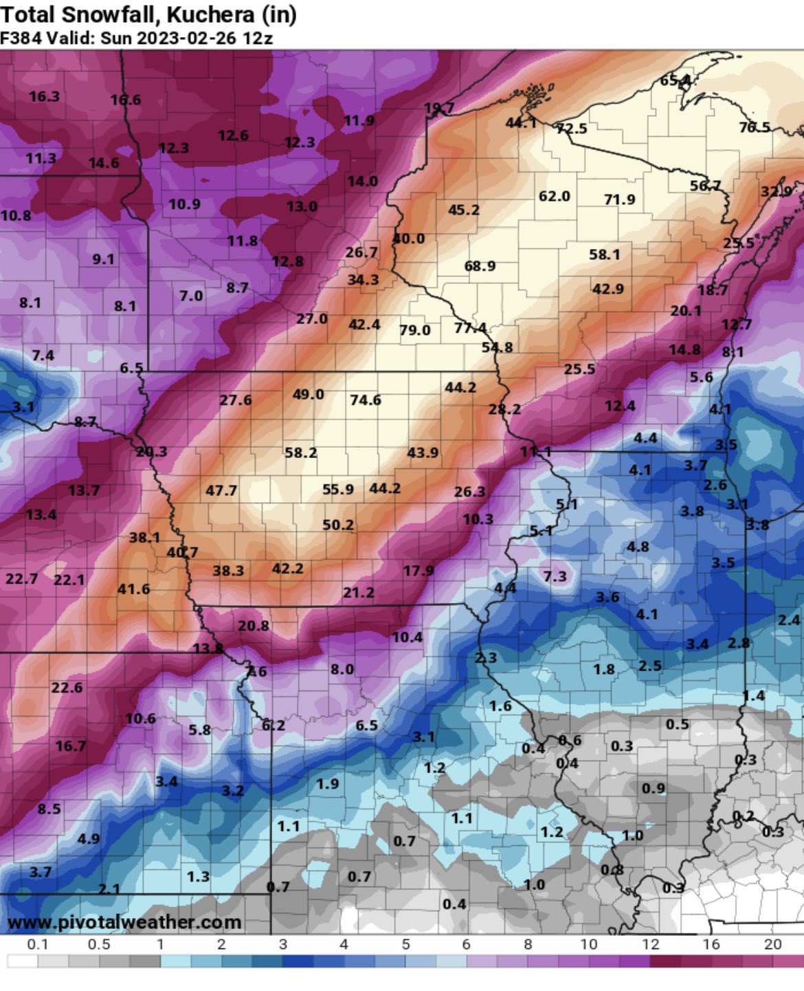
GFS continues to give S WI over 12" on kuchera ratios and over 7" in positive snow depth change. Can't see how this will be a warning criteria storm here. Looks like a slight SE trend on the Euro over the past few runs
-
1
-
-
Will this be the answer to N Illinois' prayers? Will it hit the DBQ-MSN-OSH corridor again? will it get sheared out and go far SE and weak? Stayed tuned here for the answers
-
3
-
-
1 hour ago, Baum said:
over/ under:
5.5 " MKE
4.2" Rockford
6.5" Madison
4.0 " Cary,IL
under on all of them
-
1
-
-
Who left Beavis in charge of today’s GFS?

-
6
-
 1
1
-
-
17 minutes ago, Chicago Storm said:

.On 2/8/2023 at 7:41 PM, madwx said:Time 2 jackpot
-
1
-
2
-
-
Madison got 4.8” of snow and the temp never went below 33 yesterday
-
5
-
-
still at 36 well after the storm has ended here. Arctic air has been completely absent behind ever storm system this winter besides the pre Christmas storm
-
1
-
-
4.8” with snow slowing down. Not looking forward to the upcoming shoveling
-
1
-
-
2.7" of pure concrete so far. been a little over an inch an hour since it transitioned to snow
-
3
-
-
Yeah it’s been coming down big league here since about 830. At least a couple inches on the ground and the wind has picked up tremendously. Had sleet for a couple hours before that and roads were ice covered
-
1
-
-
51 minutes ago, Powerball said:
Don't be so sure for the Michigan, Ohio and Indiana folks (lake effect clouds)...
Sucks to be them
-
3
-
-
Time 2 jackpot
-
2
-
2
-
-
25 minutes ago, A-L-E-K said:
The return of cad, we hate to see it
at least the sun will be out
-
2
-
-
up to the upper 40s. Looking like we'll do this again early next week
-
1
-
-
looks like MSN is reeling this one in. Partying like it's 2007-2009 again
-
3
-
February 2023 General Discussion
in Lakes/Ohio Valley
Posted
Got down to 6 at the house. Saw as low as 3 on the drive in to work.
This will be the first big test of sun angle season. Wall to wall sunshine vs mid 20s high temps. Will it melt the 1” of snow that drifted onto my driveway