jojo762
-
Posts
4,228 -
Joined
-
Last visited
Content Type
Profiles
Blogs
Forums
American Weather
Media Demo
Store
Gallery
Everything posted by jojo762
-
Central/Western Medium-Long Range Discussion
jojo762 replied to andyhb's topic in Central/Western States
GFS also seems to increasingly like monday as well. Tuesday looks like what could be a big day on the GFS with a very impressive, potentially higher-end environment across much of western Oklahoma and southern KS, and Wednesday ends up being a slop fest. Clearly still some differences between Euro/GFS over what day(s) will end up being favorable and how each day evolves. -
Central/Western Medium-Long Range Discussion
jojo762 replied to andyhb's topic in Central/Western States
Wednesday verbatim on the euro is easily the best setup we've seen YTD, which isn't saying much, but nonetheless still impressive. 70-80kt bulk-shear atop 2000-4000J/KG CAPE, juxtaposed to more-than-sufficient turning and speed in the lowest 0-3KM. -
Central/Western Medium-Long Range Discussion
jojo762 replied to andyhb's topic in Central/Western States
Wrong thread for that SVR warning... But the 12Z Euro and GFS seem to have come to at least some agreement on tuesday being potentially interesting... Still some differences in orientation of mid/upper level flow among other things, but definitely some agreement on dryline placement, degree of instability, timing of CI, and strength/direction of low-level flow. Also like the current precip fields, as both models appear to favor cellular activity along the dryline in OK/Southern KS. -
Central/Western Medium-Long Range Discussion
jojo762 replied to andyhb's topic in Central/Western States
I'm talking strictly about the essence of what is shown in model land and not focusing whatsoever on any other day-of issues like moisture or mid-upper level flow orientation, etc etc. -
Central/Western Medium-Long Range Discussion
jojo762 replied to andyhb's topic in Central/Western States
Not even optimistic for what amounts to an ideal synoptic setup with a trough digging into the four corners while a strong ridge dominates the east coast? Hmm... -
Central/Western Medium-Long Range Discussion
jojo762 replied to andyhb's topic in Central/Western States
Uhhh... This seems pretty ideal from the OP GFS run. Especially after the days of moisture return we are in for early/mid next week. Not going to get too excited just yet, or even attempt to predict WHEN it will happen but it definitely appears next week has some potential at some point. Euro is slower with the system than the GFS - as per usual. All GEFS members show potential at some point next week, which lends credence to some optimism. -
Central/Western Medium-Long Range Discussion
jojo762 replied to andyhb's topic in Central/Western States
Even the CFSv2 looks god awful for the entirety of its run in May. Yikes... But like BJC said, we cannot accurately predict anything with any level of certainity at this point in time. But the current indications are fairly saddening. -
Central/Western Medium-Long Range Discussion
jojo762 replied to andyhb's topic in Central/Western States
00z NAM definitely shifted west a bit. Also upped the ante a noticable amount from Eastern Kansas into Southeast OK, also showing a potential dryline bulge somewhere from E OK into SE KS... Most significant change this run seemed to be in the QPF fields supporting more of a scattered discrete/semi-discrete supercell mode along the entire dryline. Really curious to see what the SPC does with the D3 outlook. Almost certainly will expand the SLGT risk area north and westward (pending the Euro), and perhaps add an enhanced risk area (which seems warranted for at least large hail and damaging winds if not tornadoes too) somewhere between eastern Kansas and southeastern Oklahoma. NAM forecast sounding from near KC at 7pm Friday, clearly some backing above 500mb but it seems doable. However, that is a very impressive -- almost ideal, low-level hodograph. All with very low LCLs and very impressive low-level instability. If we get discrete convection that isn't messy and/or closely spaced (leading to deleterious storm interactions), its hard to believe we wouldn't be able to get low-level mesocyclones on almost every storm capable of producing tornadoes, some potentially strong and long-tracking. -
Central/Western Medium-Long Range Discussion
jojo762 replied to andyhb's topic in Central/Western States
18z NAM was incrementally faster than 12Z but verbatim it actually expanded the area of best parameters. The speed of the system, eastward movement of the dryline, in addition to the effects (and/or actual existence) of morning convection will all play a significant role in how Friday plays out. Euro/NAM both indicate a fairly active day across a large portion of the country. STP obviously does not present the whole picture, but gotta admit I was fairly impressed by this. Likewise, the tornado threat is probably limited by mid/upper level flow that is oriented nearly parallel to the dryline... However, if the system ends up just incrementally slower, we could be talking about more favorable wind profiles. -
Central/Western Medium-Long Range Discussion
jojo762 replied to andyhb's topic in Central/Western States
12Z Euro setup shows what would probably result in a widespread severe outbreak from SE Nebraska southward into NE Texas with all modes of severe weather possible including some possibly significant instances of hail, damaging winds, and tornadoes. GFS is pretty gun shy, and the NAM looks much more like the euro, but the NAM shows the main tornado threat (and a possibly significant one at that, depending on storm mode) being relegated to SE OK/W AR. -
Central/Western Medium-Long Range Discussion
jojo762 replied to andyhb's topic in Central/Western States
GFS, which is currently a bit faster with that D10+ system says NO with the GOM still largely scoured of moisture. Euro, which is slower with the system looks MUCH better in the Gulf. But another concern could be the system that is right before the one in question. -
Central/Western Medium-Long Range Discussion
jojo762 replied to andyhb's topic in Central/Western States
Friday looks maybe decent on the 00Z Euro, personally I'd stay in eastern/southeastern KS if I was chasing and hope for a supercell that wasn't in the jungle, like they will be in Arkansas. Likewise, storm-mode has me a bit concerned about the northern area due to a less than ideal mid-upper wind profile... Meanwhile, Thursday is an infuriating waste of an IMPECCABLE low-level wind field. *sigh* -
Central/Western Medium-Long Range Discussion
jojo762 replied to andyhb's topic in Central/Western States
00Z GFS and the 12Z Euro are incredibly far apart in many, many ways for 4/13... geez. The euro would appear to imply a higher-end threat for a large part of the eastern plains with an environment favorable for scattered supercells along the dryline with moderate instability and ample deep-layer and sufficient low-level shear, whereas the GFS has a very fast moving cold front with deep-layer flow mainly parallel to the front. Obviously a lot of time to work details out, but to see such a spread in the op models is not great. Even the GEFS members show a similar spread. With some supporting more of euro solution, and most supporting more of a easterly/fast solution. -
Central/Western Medium-Long Range Discussion
jojo762 replied to andyhb's topic in Central/Western States
Not a PERFECT looking setup, but a damn good looking one nonethless. If we can get flow to be just a tad less meridional looking, that'd really increase the threat level markedly imo. Anyways, this is probably the sexiest looking dryline and warm sector we've seen in quite some time. Regardless of what the "king" I said showing, this is still a week out, so probably shouldn't get my hopes up. -
Central/Western Medium-Long Range Discussion
jojo762 replied to andyhb's topic in Central/Western States
Next Friday has a fairly interesting setup on the Euro. Would likely be looking at widespread severe storms, with at least a marginal tornado threat... OR Thursday potentially if the system were to speed up, which would probably end up resulting in a higher tornado threat. -
Central/Western Medium-Long Range Discussion
jojo762 replied to andyhb's topic in Central/Western States
Putting aside all over context, this sounding SCREAMS HP supercell with intense mesocyclone. -
Central/Western Medium-Long Range Discussion
jojo762 replied to andyhb's topic in Central/Western States
Quite sad. Gives us lots and lots of time to focus on course work and regular work. ha... Generally like what late April/early May has been advertised as in almost all the long-range models, but as Quincy noted that is typically an active period anyways. Meanwhile on the CFSv2, if only this wasn't 4 weeks away in CFS fantasy land LOL... #LockItIn. -
Central/Western Medium-Long Range Discussion
jojo762 replied to andyhb's topic in Central/Western States
After these few nondescript Slight/Marginal Risk days we've had across the plains with what once looked like a conditionally promising system, we appear to be headed for an incredibly boring period of unremarkable weather systems and below average temps, followed by possibly above average temps for a brief period and more unremarkable systems. There seems to be no real chances for S/W flow across the Central or Southern plains for the foreseeable future, likely well into April. -
Central/Western Medium-Long Range Discussion
jojo762 replied to andyhb's topic in Central/Western States
Personally really like the setup on Sunday near the triple point in NW OK all three models show a conditionally volatile setup (pending mature supercells that break the cap)... The euro shows some convection, GFS shows very little, and the NAM currently shows none (albeit, it's the very end of the NAM's range). If anything does go in the progged environment it is likely to be significant severe, and given the wind profile should be supercellular and isolated. Monday presents a very tricky forecast, but there will almost certainly be severe storms, and possibly several tornadoes. -
Central/Western Medium-Long Range Discussion
jojo762 replied to andyhb's topic in Central/Western States
Given the differences between the GFS and euro it's a fairly low confidence forecast for now. But even the euro would feature a couple days of at least slight-risk caliber severe chances, obviously with various caveats and conditions. Whereas the GFS shows a fairly robust, but imperfect, setup along the "classic" I-35 corridor on sunday. -
Central/Western Medium-Long Range Discussion
jojo762 replied to andyhb's topic in Central/Western States
Euro looks pretty potent for next weekend as well. Frivolous to get into much detail, but looks fairly promising for a day or two of solid severe chances somewhere across the central/southern plains. -
Central/Western Medium-Long Range Discussion
jojo762 replied to andyhb's topic in Central/Western States
Definitely looks interestingly at this point in time. SPC provides a good take: "It appears that one or two short wave perturbations on the leading edge of this regime may dig to the lee of the Rockies and contribute to significant surface cyclogenesis anywhere from the southern Plains into the lower Mississippi Valley, and across parts of the Southeast, next weekend. Guidance remains suggestive that this could be accompanied by a fairly rapid and substantive moisture return off the Gulf of Mexico, providing potential for destabilization supportive of an increasing severe weather risk. Due to the rather large spread among the model output concerning these developments (associated with low pattern predictability and the extended time frame), severe weather probabilities for next Saturday/Sunday currently remain generally low, but it is at least possible that this could change during the coming days." -
Central/Western Medium-Long Range Discussion
jojo762 replied to andyhb's topic in Central/Western States
GFS seems to be slowly trending toward a tad better moisture return... Likewise forecast soundings on the 18Z GFS are seasonably impressive along a narrow corridor in close proximity to the dryline on Sunday evening from SW OK into SC KS, featuring an ideal hodograph for low-level mesocyclones and modest instability, not the best moisture quality obviously but probably do-able with the low LCLs, something of note is fairly respectable low-level instability which plays a significant role in tornadogenesis. This will be a fairly impressive early season setup (low/mod CAPE/ high shear) if we can just get a little more breadth to the axis of greatest instability. Not looking like an overly significant event attm, but definitely an interesting day for the beginning of March in the plains. BTW. this sounding is from just west of Enid at 6pm Sunday.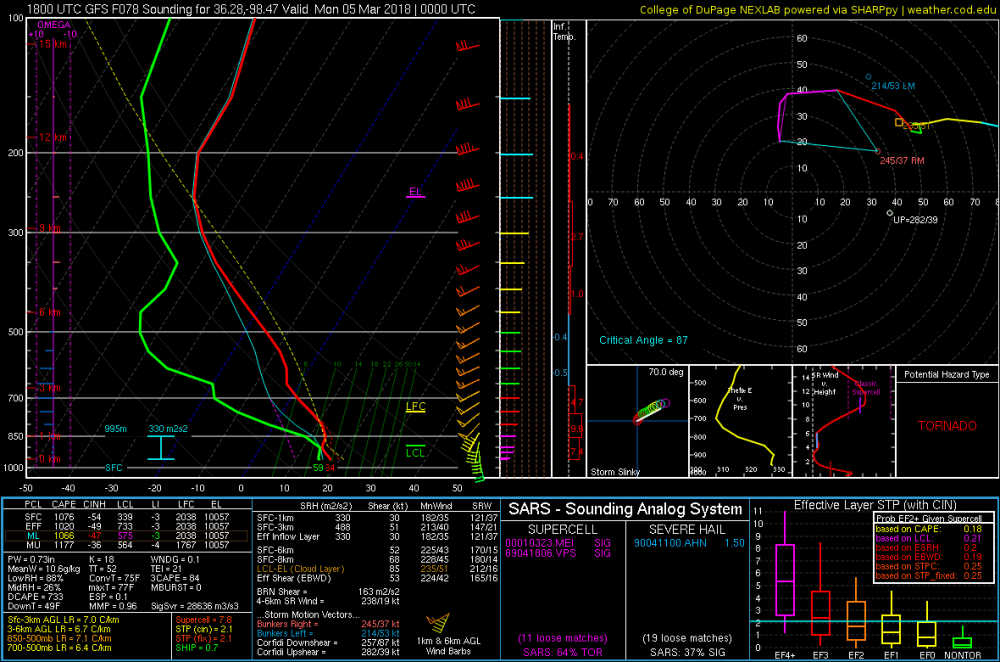
-
Central/Western Medium-Long Range Discussion
jojo762 replied to andyhb's topic in Central/Western States
Not sure why I mentioned overturning, misplaced some of the precip and VV maps in my head apparently while doing calc. Will be interesting to watch this evolve tonight, tomorrow and into this weekend. Any meaningful uptick in instability and moisture dramatically improves this system's prospects from what I can tell. -
Central/Western Medium-Long Range Discussion
jojo762 replied to andyhb's topic in Central/Western States
Perhaps I am over-emphasizing this in my head with the very strong mid/upr trough overhead providing impressive forcing for ascent, but the 100-120+J/KG of CIN in the GFS soundings at 00z Monday (6pm Sunday) sticks out like a sore thumb to me. If we were to just get a relatively minor 3 to 5-degree improvement in DPs from what the 18z GFS run already progs in addition to less downstream convective overturning from crapvection earlier in the day, we would have an entirely different conversation on our hands, that is if you take the extremely impressive kinematics verbatim. Wind fields will probably be there as both the GFS and EURO show relatively similar setups attm imo. The current extreme D3 drought over the area where the dryline is currently progged to be lends to some additional concern over moisture quality as well.