

FlatLander48
-
Posts
2,037 -
Joined
-
Last visited
Content Type
Profiles
Blogs
Forums
American Weather
Media Demo
Store
Gallery
Posts posted by FlatLander48
-
-
Not that I really believe it's an implication of anything, more of just a note I'm making: If you look at hour one of the NAM and compare it to current radar for say Texas, since that's where part A of our storm will get going, there's a considerable amount more moisture around than even the NAM is showing. Again, just a note.
-
 2
2
-
 1
1
-
-
Considering the thing starts tomorrow, theres still a lot of variance in plumes for Boone. Average is just over 2 inches. Theres 3 members in the 7 inch range, and a bunch just scattered all over the place.
-
23 minutes ago, griteater said:
Headlines - Spring put on hold / Eyewall gets hit again. It's February 1989 all over again


Just in time for my vacation flight out of Asheville... lol
-
Latest round of plumes for Boone average just under 2 inches if you take out the one outlier at 10 inches. I'll take it I guess.
-
Just now, lilj4425 said:
It’s over folks. The ICON (whatever the heck that is. Is it Japanese?) says all rain.
German I think. But yes lol
-
5 minutes ago, WarmNose said:
One bad run and we get trolled by somebody from the MA forum hugging the RGEM. Let us live

They just salty they don't get to share the delight of tracking this one with us
")
-
1
-
-
Just now, stormtracker said:
lol at bailing based on the ICON
To be somewhat fair, the ICON has had it's glory moments over the past few seasons that it's been publicly available, not saying it's onto something by any means.
-
 1
1
-
-
14 minutes ago, StantonParkHoya said:
I can’t believe sun angle hasn’t been mentioned once. You SE crew are a more upstanding group than us degenerates in MA.
Sun angle usually doesn't get mentioned here til the day before. Usually snow modeled 24+ hours away generally turns to rain before we have a chance to talk about it.
-
 1
1
-
-
5 minutes ago, Met1985 said:
The mountains are always in a prime spot.
To the south of where I'm at sure. We have yet to hit 3 inches in Boone for the entire winter.
-
1 minute ago, wncsnow said:
I'm good with a little more north but not too much!
I need about 200 more miles apparently. Will that work for ya? If not we can negotiate lol
-
1 hour ago, buckeyefan1 said:
 There were a couple that did that. There was also the one who made two accounts..... 1300m and I forget who his split personality was
Am I mistaken thinking that DT or wxrisk used to be on here?
-
Gonna whisper in here as to not disturb the main thread.... I STILL want this thing to come way north lol
-
2
-
1
-
-
Well, it does look like the NW mountains are still the weak spot for this storm for our area. Still wouldnt mind a couple more jogs to the NW
-
6 minutes ago, BornAgain13 said:
So are the globals really that important right now? Just curious of y'alls thoughts .. or should we focus more on short range
Yes, globals are always important, especially now, as there are still not enough short term modeling to go by at this range.
-
1
-
-

For funsies: talk about a freaking nice storm for us.
-
2
-
-
Really wish we could get the storm to rake up the coast instead of heading almost due east, would help our totals a lot, but I'll take it. Though at this point, the coast stands to see more snow in 24 hours than Boone has all winter, with this storm included lol
-
2 minutes ago, AsheCounty48 said:
GFS at Hour 42, I believe that the trajectory looks the tiniest bit more of a SW/NW flow, believe it will come north a tad, though nothings stands out really compared to the 6z.
Hour 48, 50-75 mile push north compared to 6z. Also showing a tendency at the same time frame over the last couple of runs (still at 48) of the storm appearing stronger each run. at least in terms of precip rates.
-
2
-
-
GFS at Hour 42, I believe that the trajectory looks the tiniest bit more of a SW/NW flow, believe it will come north a tad, though nothings stands out really compared to the 6z.
-
2 minutes ago, wncsnow said:
it's still suppressed
Yea, if anything it looked a little more suppressed than the 6z, thought not by much. It is at the end of it's range at that point, but worth keeping an eye on.
-
Man...if yall thought living and dying by each model run was bad before, today is gonna be popcorn worthy.
-
2
-
-
Even though the end of the range isn't really close enough to point out storm details for us, the RGEM is another tool starting to come into play to see how far north the precip will be before it gets here. The 6z was considerably further south and flatter compared to the 12z Nam, would like to see it correct towards the NAM on this run as it's coming in.
-
4 minutes ago, Met1985 said:
The 12z NAM is holding serve. Kind of starts out as a mix but quickly turns to all snow. The precipitation is much further north this run also. It really blossoms out once it gets in here.
Good run for all the mountains. Believe that was the best run from any model for what we want. minus the bit of mix at onset of course.
-
2
-
-
Isnt the saying that dont worry about precip, instead worry about what the upper levels say until about 48 hours out? Or is that applied only when every model shows a lot of snow.
-
3 minutes ago, Holston_River_Rambler said:
Here's the 6z Euro for y'all too:
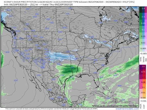
That's a considerable difference. Preferably would be nice to see the LP form a bit closer to the coast. But baby steps at this time.
-
2
-
2019/2020 Mountains and Foothills Fall/Winter Thread.
in Southeastern States
Posted
SREF plumes adjusted as well. Average of around 3 inches in Boone, and a few members (not just one like earlier) are showing 8-10, so could continue to go up possibly.