Mailman
-
Posts
1,653 -
Joined
-
Last visited
Content Type
Profiles
Blogs
Forums
American Weather
Media Demo
Store
Gallery
Everything posted by Mailman
-

Western Pa / Pittsburgh area Winter Discussion ❄️☃️
Mailman replied to north pgh's topic in Upstate New York/Pennsylvania
High Rest NAM: -
Western Pa / Pittsburgh area Winter Discussion ❄️☃️
Mailman replied to north pgh's topic in Upstate New York/Pennsylvania
lol. -
Western Pa / Pittsburgh area Winter Discussion ❄️☃️
Mailman replied to north pgh's topic in Upstate New York/Pennsylvania
.SHORT TERM /WEDNESDAY THROUGH WEDNESDAY NIGHT/... An upper level split-flow wave will cross the Ohio Valley into the mid-Atlantic Wednesday into Thursday, bringing a swath of moisture across the Upper Ohio. Associated sfc low pressure will develop across the upper Mississippi Valley before deepening off the Carolinas and riding up the Atlantic coastline. Transient left-exit and coupled jet support are progged to generate broad ascent to support mainly snow beginning Wednesday morning, then ramping up during the afternoon and overnight. Significant uncertainty remains with regards to snow amounts across the forecast area. Deterministic and ensemble guidance continue to support a large range in possible snow totals, primarily due to large differences in QPF amounts and placement of the sfc low to our east. The 00z ECMWF run in particular places the sfc low much farther west and north than previous cycles, though without full EC ensemble and other deterministic agreement, this was not enough reason to significantly inflate our official snow totals at this time. Some question also remains with the extent of warm advection across the lower elevations of WV into SW PA on Wednesday afternoon/ early evening as this could impact initial snow totals. With further penetration of warm air, some potential also exists for brief freezing rain across this area and into the lower ridges. However, the window for this is small, as more substantial warm advection would likely bump marginal sfc temperatures above the freezing mark. Rapid system progression also presents a barrier to high snow totals, as the system quickly shifts off the coast early Thursday morning and shuts off efficient snowfall. Highest snow totals remain over the Allegheny Mountains and ridges, with lesser snow farther west. Confidence in 8+ inches of snow is high enough across the higher elevations to support an upgrade from Watch to Winter Storm Warning in those areas. With increased snow amounts forecast farther west, the Watch was also expanded to include areas including Pittsburgh. Lower confidence exists across the lower elevations of Monongalia and Marion counties where warmer temperatures will likely inhibit initial snowfall totals. Watches and Warnings are in effect from 7AM Wed through 7AM Thu. Advisories will likely be needed for areas farther west, especially if the upward trend continues. -
Western Pa / Pittsburgh area Winter Discussion ❄️☃️
Mailman replied to north pgh's topic in Upstate New York/Pennsylvania
-
Western Pa / Pittsburgh area Winter Discussion ❄️☃️
Mailman replied to north pgh's topic in Upstate New York/Pennsylvania
What the Canadian took away at 12z, we got back at 0z. Nice! -
Western Pa / Pittsburgh area Winter Discussion ❄️☃️
Mailman replied to north pgh's topic in Upstate New York/Pennsylvania
-
Western Pa / Pittsburgh area Winter Discussion ❄️☃️
Mailman replied to north pgh's topic in Upstate New York/Pennsylvania
Would be nice to see the GFS move closer to the others here within the next hour just to lessen my doubts a little. -
Western Pa / Pittsburgh area Winter Discussion ❄️☃️
Mailman replied to north pgh's topic in Upstate New York/Pennsylvania
3k NAM (warm tongue looms for me): -
Western Pa / Pittsburgh area Winter Discussion ❄️☃️
Mailman replied to north pgh's topic in Upstate New York/Pennsylvania
-
Western Pa / Pittsburgh area Winter Discussion ❄️☃️
Mailman replied to north pgh's topic in Upstate New York/Pennsylvania
NAM looking good. -
Western Pa / Pittsburgh area Winter Discussion ❄️☃️
Mailman replied to north pgh's topic in Upstate New York/Pennsylvania
KPIT SREF Plume (15z -- mean 7.4"):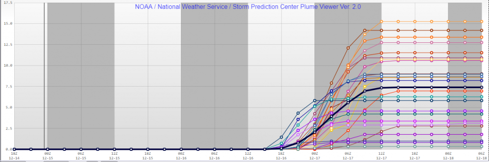
-
Western Pa / Pittsburgh area Winter Discussion ❄️☃️
Mailman replied to north pgh's topic in Upstate New York/Pennsylvania
Hmph. Just not enough liquid here. -
Western Pa / Pittsburgh area Winter Discussion ❄️☃️
Mailman replied to north pgh's topic in Upstate New York/Pennsylvania
High res NAM (still snowing at 60h): -
Western Pa / Pittsburgh area Winter Discussion ❄️☃️
Mailman replied to north pgh's topic in Upstate New York/Pennsylvania
NAM definitely doesn't have surface temp issues. -
Western Pa / Pittsburgh area Winter Discussion ❄️☃️
Mailman replied to north pgh's topic in Upstate New York/Pennsylvania
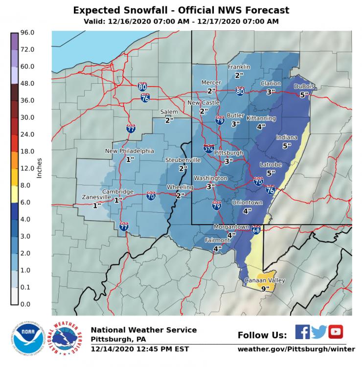
Their discussion is conservative, as well. I miss Fries. .SHORT TERM /TUESDAY THROUGH WEDNESDAY NIGHT/... Building high pressure on the van of deepening Plains low pres will bring dry weather for Tuesday with near-average temperature. That split-flow low is projected to dig over the Midwest by Wednesday and shunt a swath of mid level moisture over the Upper Ohio. Transient left-exit and coupled jet support are progged to generate broad ascent to support categorical POPs on Wednesday, mainly in the form of snow. System progression and temperature profile will be the inhibitors for snow acccumulation over much of the area as mid level warm advection degrades dendritic growth potential and as boundary layer warmth (32-34F) reduces impact potential. Nevertheless, an accumulation of heavy, wet snow is expected but with primary impact limited to the ridge-areas where a Winter Storm Watch remains in effect. -
Western Pa / Pittsburgh area Winter Discussion ❄️☃️
Mailman replied to north pgh's topic in Upstate New York/Pennsylvania
-
Western Pa / Pittsburgh area Winter Discussion ❄️☃️
Mailman replied to north pgh's topic in Upstate New York/Pennsylvania
Seems to be the best Euro run for us since Friday night. -
Western Pa / Pittsburgh area Winter Discussion ❄️☃️
Mailman replied to north pgh's topic in Upstate New York/Pennsylvania
-
Western Pa / Pittsburgh area Winter Discussion ❄️☃️
Mailman replied to north pgh's topic in Upstate New York/Pennsylvania
Euro seems to be a little bit of an improvement from 0z. -
Western Pa / Pittsburgh area Winter Discussion ❄️☃️
Mailman replied to north pgh's topic in Upstate New York/Pennsylvania
Canadian has cut our totals in half from 0z. -
Western Pa / Pittsburgh area Winter Discussion ❄️☃️
Mailman replied to north pgh's topic in Upstate New York/Pennsylvania
Not speaking specifically to this sub forum, but feels like there will be a lot of disappointment across the board with this one. -
Western Pa / Pittsburgh area Winter Discussion ❄️☃️
Mailman replied to north pgh's topic in Upstate New York/Pennsylvania
-
Western Pa / Pittsburgh area Winter Discussion ❄️☃️
Mailman replied to north pgh's topic in Upstate New York/Pennsylvania
.SHORT TERM /6 PM THIS EVENING THROUGH WEDNESDAY NIGHT/... High pressure will build ewd from MI in the wake of the daytime wave. Modest potential for light lake-enhanced snow showers to the north of I-80 lingers this evening for a few hours before dry air and subsidence erode any remaining CAPE. High pressure will remain dominant through Tue eve as a strong low develops in the Plains. As this Plains low advances ewd toward the Ohio Valley, coastal low pressure will strengthen considerably as an upper-level jet advances ewd. Strong upward motion associated with the left exit region of this jet/possible pairing with a secondary jet's right entrance region will favor high precipitation rates Wed afternoon and early eve, especially across the sern half of the forecast area. While precipitation rates will be high and vertical motion will be strong through the dendritic growth zone, increasing warmth aloft and sfc temperature in the 32-34F range will reduce snow ratios a bit, leading to a heavy, wet snow. The highest totals will occur se of a line from DUJ-CKB, where upward motion will be maximized and terrain will facilitate colder low-level temp. There will be a sharp gradient in higher totals nw from this axis, but snow is expected in all locales at some point on Wed aftn. A Winter Storm Watch is in effect for Wed/Wed night focused especially on the ridge zones, where highest totals and impactful heavy, wet snow are expected. An advisory likely will be needed adjacent to these zones, which will be highlighted in the HWO. -
Western Pa / Pittsburgh area Winter Discussion ❄️☃️
Mailman replied to north pgh's topic in Upstate New York/Pennsylvania
-
Western Pa / Pittsburgh area Winter Discussion ❄️☃️
Mailman replied to north pgh's topic in Upstate New York/Pennsylvania
NAM'd.