

cbmclean
-
Posts
3,053 -
Joined
-
Last visited
Content Type
Profiles
Blogs
Forums
American Weather
Media Demo
Store
Gallery
Posts posted by cbmclean
-
-
Multiple Ravens/Chargers connections in my fantasy matchup this week. I have Gus Edwards and Justin Tucker. My opponent has Austin Ekeler, Cameron Dickler, and the Ravens D.
I guess that means I root for Edwards to dominate on the ground but for Lamar to get sacked back to the 50 yard line and Tucker to hit multiple 60+ yard fields goals. Meanwhile the Ravens D to crush Ekeler and Dickler but let everybody else run wild.
-
7 minutes ago, DarkSharkWX said:
EPS still looks good
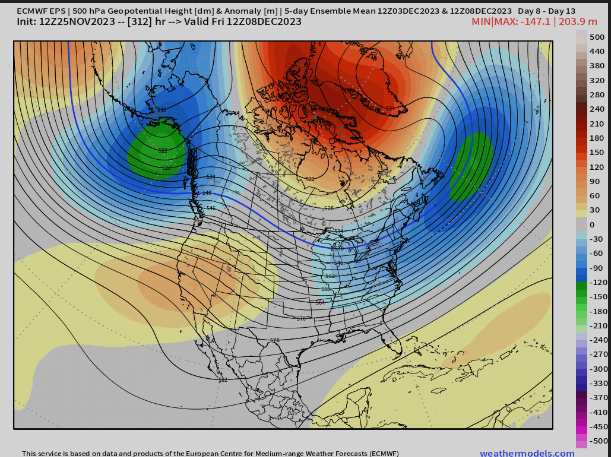

Still too much GOA low pumping most of the CONUS full of pack puke. The NAO is keeping it seasonable in our areas. Hopefully the Pacific continues to improve.
-
 2
2
-
-
Just now, brooklynwx99 said:
that is the exception rather than the rule. a strong -NAO almost always overpowers unless the Pacific truly sucks
Yeah, but the Pacific truly sucking has been the base state for 7+ years, so we have to at least take that into consideration.
-
3 minutes ago, AtlanticWx said:

where?
Ah I didn't notice the switch from Gefs to Eps. Carry on.
-
2
-
-
15 minutes ago, brooklynwx99 said:
pretty mint IMO
The continet-wide positive temp anomalies don't concern you?
-
Honest question: Would a-NAO really be of interest? Didn't we learn last December that it is powerless against a bad PAC?
-
1 hour ago, Stormchaserchuck1 said:
How about these run to run model changes? Now we have a -PNA and -NAO??


That didn't work for us last year. We toss.
-
46 minutes ago, LeesburgWx said:
If we don’t get an inch until January, this board will implode
This board imploded sometime in March of last winter. We're just trapped in the event horizon of the supernova remnant. That's why the PSU inch joke seems to be stretching to infinity.
-
1
-
 6
6
-
-
1 hour ago, psuhoffman said:
I swear I don’t want to see another Eagles lineman with a clean shot try to arm tackle Mahomes. Just launch into him and obliterate him.
That would be a 25 yd penalty for tackling a popular QB
-
1
-
-
52 minutes ago, Maestrobjwa said:
I question how important it is to have this discussion for us to have in this forum where pretty much everybody knows where we are and what a fail this winter would mean? I'd like to think 99% of don't need to be convinced of that...especially not after alllllllll the endless discussion of our climo the last few winters. It's like preaching to the snowy choir, lol
Just scroll past them.
-
1
-
-
2 hours ago, Eskimo Joe said:
For that to work in our favor, we want it to bleed south slowly and really pour into the US to our west.
Haven't we played that game multiple times the last few years? The cold gets trapped in the west and can't make it over the mountains while we toast. The eastern CONUS loses either way. I enjoyed the Christmas cold shot last year for what it was. I definitely enjoyed it more than the 2015 torch.
-
4 hours ago, CAPE said:
Spire lookin good
")
I'm loving this ----EPO eye candy, but is it reasonable to be concerned that maybe this is too much of a good thing, especially so early in the NH cold season? Will the air of the source region have even had time to really chill in the polar night? If it discharges before it's had time to "marinate", will we just be left with a marginal early seaon cold outbreak and a depleted source region?
Of course this is all just a hypothetical concern assuming the modeling even comes close to verifying.
-
19 minutes ago, Terpeast said:
Some of these are reasons to temper our expectations, but an east based nino isn’t one of them. Based on -VP forcing plots, this nino is anything but east based. Forcing is very west-leaning
Shhh, don't let Webb hear that...
-
1
-
-
2 hours ago, Eskimo Joe said:
Then we warm back in December and folks like me and Ji screech.
I'm too lazy to look at the numbers but last December actually wasn't that warm as averages go. I think it was a actually a bit BN here at RDU. But of course most of that was due to the epic Xmas week cold snap. Every time systems came through the SER flexed and the east coast had a classic warm wet/cold dry.
My one bar is NOT being ~80 F on Xmas day like in 2015 at my parents house.. I'm legitimately concerned.
-
2 hours ago, Eskimo Joe said:
He will always, always push a solution that gives him snow and the east coast nada.
And last year at least he was right. Every. Single. Time. I find it hard to hate on him until he is actually incorrect for once.
He's actually from very near my hometown in central/SE North Carolina. Not sure why he has the feud with the East Coast snow weenies but his joy at their suffering is unseemly.
-
 1
1
-
-
Got 2.62" from Ophelia. 3.24" for the week. A good rehydration.
-
A thin line of storms but very slow movement yielded 0.93". Hoping for some more tomorrow.
-
Virtually no movement on the radar. One of those days where a cell has to form on top of you or you get nothing.
-
1
-
-
0.29" today, for 1.96" over the last three days. The garden and grass needed that.
-
1.42" from the storms today. Much needed.
-
A disappointing 0.26" in the bucket from the squall line. The line was too thin and moving too fast. Hopefully we can get some more later this week.
-
Don't normally get too excited about morning rain because it is often light and usually interferes with better convection later in the day. But this morning delivered a solid 1.16", my first inch-plus day in a while.
-
2
-
-
Got 0.87 from the line. Respectable given the fact that the line seemed to be weakening after passing the triangle (some of that may have just been radar artifact) and how speedily the line was moving. Ended up with 1.48" from the active spell. Not horrible but wish I could have had a bit more given the abundant moisture throughout the column, the lack of longwave ridging but also plenty of heat to create instability, as well as the constant stream of shortwaves. This upcoming week looks dry as of now.
-
1 minute ago, NorthHillsWx said:
Just 0.22” but it felt nice getting something to wet the yard/garden after 2 weeks of missing everything. .26” for the day 0.43” for July
I know the feeling. Have had five separate instances of rain over the last four days but only netted 0.61". Grateful to have it but still hoping for a good inch plus soaker. Maybe today is my day.


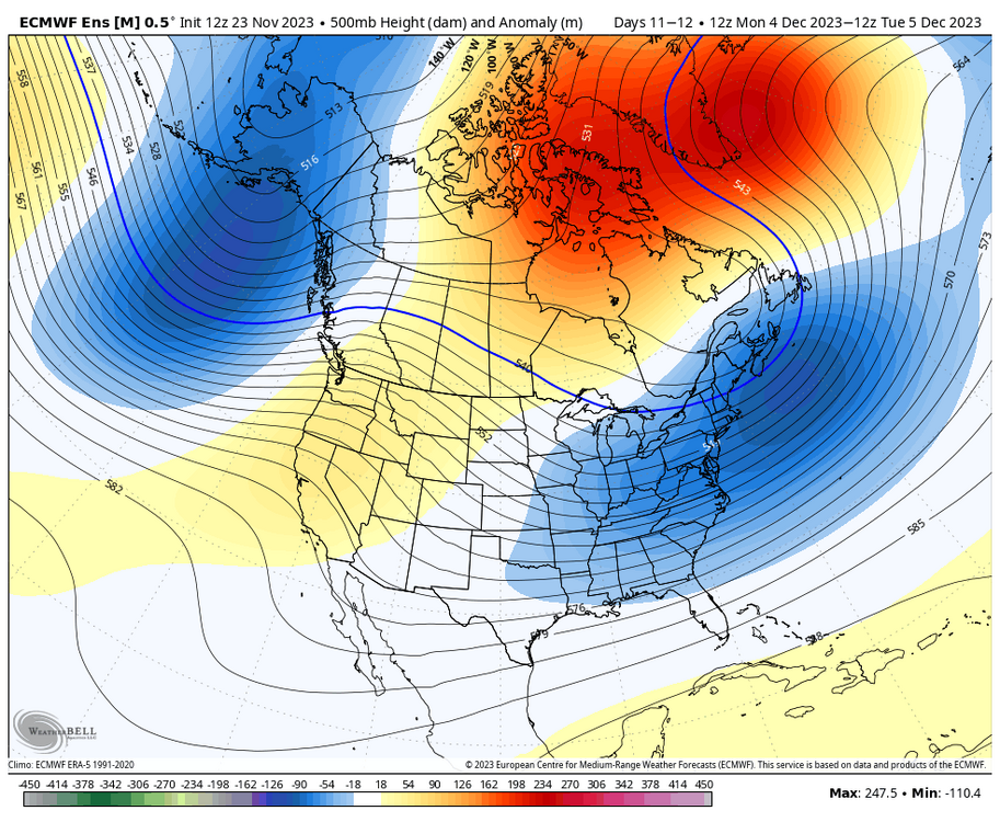
December Mid/Long Range Discussion
in Mid Atlantic
Posted
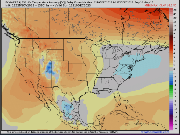
My understanding is that El Nino winters are often backloaded, so this would make sense. My personal goal as a SE weenie is just to have December be seasonable instead of a torch. That would be a huge win.
Maybe you guys can get lucky with good timing with marginal temperatures.
ETA: I meant lucky with marginal temps in December. Hopefully No luck needed in Jan Feb.