

jm1220
-
Posts
22,994 -
Joined
-
Last visited
Content Type
Profiles
Blogs
Forums
American Weather
Media Demo
Store
Gallery
Posts posted by jm1220
-
-
Looks like storms/rain will split N and S of the city/LI.
-
46 minutes ago, uofmiami said:
Only got to 83 & 84 at my stations today.
My high was 82 I think. If winds could've been SW for a while instead of due S, we would've been upper 80s.
-
 2
2
-
-
Anyway-perfection today. 80 currently
-
1
-
-
18z GFS for the weekend....

Let's just hope it's wrong.
-
1
-
-
2 hours ago, bluewave said:
Yeah, temperatures should peak midweek before the cold front arrives. Places like Newark could reach 90° if the flow goes more SSW instead of the current SSE forecast with the slight bend in the streamlines. Best bet to reach 90° is probably in Central NJ away from the sea breeze. Plus areas from Albany to New Hampshire could reach 90° since sea breezes won’t be an issue there. Even your area on the North Shore could get into the 80s. Looks like a step down in temperatures as the stronger onshore flow returns by Memorial Day.


I don’t think 80s will be an issue here as long as there’s some westerly component to the wind. The barrier beaches of course are another story.
-
5 hours ago, bluewave said:
While it’s too early to do a rainfall or clouds potential forecast for Memorial Day, looks like we could see more onshore flow with high pressure anchored east of New England.


That second map especially looks like garbage for us. Hopefully it's wrong. I agree that midweek should be warm if we can get a westerly flow of some kind finally.
-
1
-
-
1 hour ago, bluewave said:
The Euro has an over the top warm up next week with 90° potential in New Hampshire and 80s around Newark. Looks like just enough SSE flow at Newark to push against the 90° there. But if the winds can go more SSW for a few hours ,then Newark could sneak in a 90°. But this onshore influence has been so strong that it may be a challenge.

90 in Concord and 70 here with low clouds probably. That would be a kick in the teeth.
-
9 minutes ago, nycwinter said:
that will not pan out hot and wet for nyc for 3 month period not going to happen;
It can be a wet month in the summer if we have a tropical system come in for 2 days and we have 15 days over 90 for a high, or our normally high overnight lows. It’s expected to be a hyperactive hurricane season so it’s certainly doable.
-
Just now, nycwinter said:
hot and wet makes no sense...
Sure it does. In the summer you can get rounds of storms drop 3-5” in a day or two while a heat wave or two on other days pushes temps overall well above average.
-
Starting to clear out here.
-
Another day, more gunk. Looking forward to our one nice teaser day before another 4 days of gunk.
-
1
-
-
2 hours ago, bluewave said:
These over the top warm ups have become a familiar theme.

Which will start more wildfires up there and the smoke will come south again with these troughs bringing northerly winds. Again like clockwork.
-
 1
1
-
-
2 hours ago, Allsnow said:
I better get good weather on Memorial Day weekend
Eventually this has to change but we all know what a closed upper level low south of us means. Yesterday on the GFS for 7 straight days it had easterly winds of some kind. Maybe we can get low 70s with that when we can get the sun to come out, definitely no heat. And anywhere near a barrier beach maybe you can get mid 60s. Hopefully that map is wrong.
Big patch of cold SSTs east of us now with this endless cool/easterly wind pattern.
-
39 minutes ago, psv88 said:
More than that. Heavy rain moving west now. East end pushing 2 inches. Look at those feeder bands moving onshore. Looks like a tropical system. Windy out there too
Models bring some heavier rain west, we'll see how much makes it here. So far IMBY everything's been light. But definitely a drencher E of the William Floyd.
18z GFS has NE or E winds straight through 144 hours. At the mercy of whatever the Maritimes puke up.
-
27 minutes ago, psv88 said:
0.49” today.
yay
Sheet drizzle city!
-
17 hours ago, Stormchaserchuck1 said:
Do you know how much snow Boston has received vs average 2017-18 to 2023-24? If it's less than 50% that's a huge bad omen for areas south on the east coast going forward through the next few years and maybe decades.
I think it may be luck turning around for BOS. This year I did better than them on LI (15.5” here, not saying much), last year I had about the same, 21-22 BOS had more largely because of the late Jan storm that was 24” 20 miles east of me and 14” IMBY, 20-21 I did better because of the early Feb big run we had. 2017-18 through 19-20 BOS probably did better but 17-18 was also good/great here so it might’ve been about even. The Jan storms in 2022 and 2018 slammed as far south as the Delmarva so it’s really about the crap pattern favoring the West/Plains/NNE we’ve all been stuck in. When the boiling W PAC cools down so the rampaging PAC jet can take a break, it should turn back around. After the general 2000-2018 bonanza period we were due for a stretch of garbage.
-
1
-
-
1 hour ago, brooklynwx99 said:
1988-89, 1995-96, 1998-99, 2005-06, 2010-11, 2019-20, and 2020-21 are all fine analogs for now IMO. no real way to know which are better than others at this point given that we don't even know how the Nina is going to evolve at this point
for the record, I am not expecting a good winter for the East. however, the two things that can help are a bit of Nino lag (helped in 95-96 and 2010-11 most notably) and high ACE, both of which likely have some kind of impact. we can just as easily see another dud, which is safer to expect
the rubber band does have to snap back at some point... positive regression to the mean is pretty much imminent. would be ironic if we do see one of the good Nina winters in a year where people are expecting so little
I expected 2020-21 to be horrible going into it so that’s a good point. 10-11 was the second best season I’ve lived through after 95-96. But we lucked out with blocking at the right times, we’ve seen the SE ridge be so insane that it links up with the NAO block now. Obviously that would be a disaster. But Nina isn’t a game over by itself from PHL north.
-
1
-
-
39 minutes ago, TriPol said:
This feels like the coolest spring we’ve had in a while. Sure, we’ve had a handful of 70s and 80s, but most of it has been 50s.
It’s that we can’t get a streak of warm weather going. One nice day then back to the gunk. And usually by now we have a day or two close to/over 90. But we need westerly flow for that which has been nonexistent.
-
3
-
-
Good-rinse the pollen away. It’s awful.
-
2
-
 1
1
-
-
32 minutes ago, 40/70 Benchmark said:
Honestly, though.....A near record ACE seems to be the only way out of another torpedo DM period, and even then....maybe just servicable. 1998 was pretty active in terms of ACE and it still sucked. I imagine the ceiling could be something like a 2007-2008 outcome, where there is an ample reservoir of cold over eastern Canada via an elongated PV, but there is a sharp gradient due to a se ridge adjoining.

07-08 was garbage here with endless SWFEs that were awesome for I-90 and sleet to rain here. If that’s the “ceiling” even with the high ACE it’ll be the earliest slam the blinds shut in history. This official Nina or Nina background state with the boiling W PAC that fuels the PAC jet on steroids has to end before us south of I-90 have a shot at a good winter again. This state that started up in 18-19, other than the 20-21 rabbit out of a hat good winter makes that clear as day to me.
-
1
-
-
1 hour ago, Stormlover74 said:
And gfs is fairly dry too but has a weekend washout
.thumb.png.0048eefae25a96d210b5f0b0c18b2282.png)
The trend over the last couple of weeks has been for the -NAO/blocky back door pattern to squash these south and/or dry them up from confluence coming from the NE. We’ll see if one of these can break the trend.
-
3
-
-
8 minutes ago, Brian5671 said:
Been the story of the month here-while we've had some rain it's grossly underperformed model output
I mean it’s not the worst in the world-Sat and a good chunk of yesterday turned out nice but the drying came from the NE. The rain struggled like anything making it east from the city into the dry air.
-
2 hours ago, Brian5671 said:
GFS has nothing for Wed while the NAM and RGEM are fairly wet

The back door pattern is so entrenched that we have confluence and dry air coming in from the NE which eats up the rain.
-
1
-
-
3 minutes ago, MANDA said:
Canadian forest fires are underway. Smoke affecting the Northern Plains into the Great Lakes. Air quality alerts are posted over parts of MN and WI.
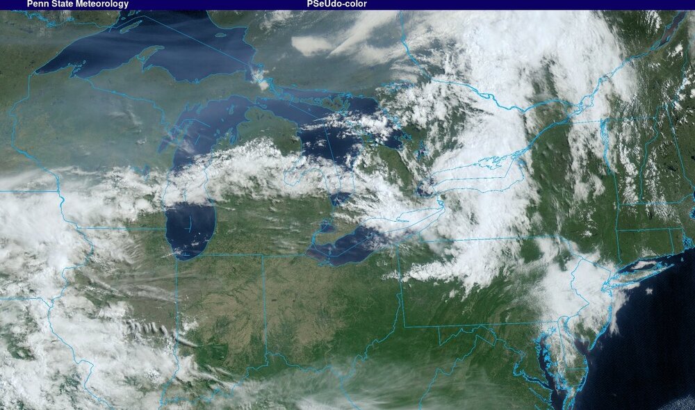
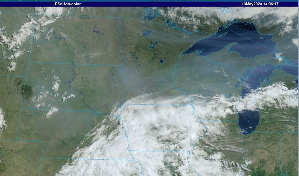
Like clockwork.


.png.d03bb14fd5135c0d26d4e984755f45cd.png)


May 2024
in New York City Metro
Posted
Winds off the sound here, compressional heating down there. 81 in Long Beach, 76 here.